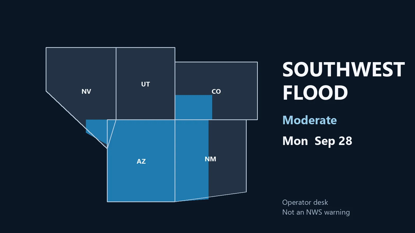
This is a live Monday morning snapshot of U.S. local-storm activity as of Monday, September 28, 2026. Overnight into this morning, the organized severe desk stayed quiet. The Storm Prediction Center 1300 UTC Day 1 Convective Outlook has no severe thunderstorm areas forecast. No convective watches are valid. The Weather Prediction Center holds a Moderate Risk of excessive rainfall over portions of the Southwest and Four Corners as tropical moisture associated with Hurricane Polo and remnants of Odalys lifts north into already wet ground.
These are county- and ZIP-scale thunderstorms and flash-flood pulses, not a U.S. mainland hurricane landfall. Polo is still a major hurricane approaching Baja California Sur and Sonora. Restoration exposure today is water first in the Southwest, then isolated wind and hail cleanup from last night’s High Plains and north Texas cells. Conditions change fast. Verify with the National Weather Service for the specific county or ZIP before you roll.
What is live this morning
SPC language at 0728 AM CDT: severe thunderstorm probability remains low on Monday. Isolated to scattered storms are still expected later over the northern High Plains from western Nebraska into the Dakotas, and numerous showers and thunderstorms are expected across southeast California, southern Nevada, and western Arizona. Those corridors do not carry unconditional severe probabilities on this outlook. The last issued convective watch was number 0674; nothing is live now.
WPC Day 1 excessive rainfall, issued 0812 UTC Monday and valid 12Z Monday through 12Z Tuesday, is the headline. A Moderate Risk covers portions of the Southwest and Four Corners. Guidance supports a widespread 1 to 3 inches across the region, with south- and west-facing slopes along the Mogollon Rim and the San Juans favored. Precipitable water is forecast 2 to 3.5 standard deviations above normal. Burn scars, rocky soils, and slot canyons locally raise the flood threat. The Moderate outline forks farther south in New Mexico toward the Lordsburg area and the Sacramento Mountains.
A weakening cyclone near the southern New England coast still supports showers and occasional embedded thunder along the coast. Instability is weak. That is leftover nor’easter weather, not a new severe corridor.
Hotspot 1 — Southwest and Four Corners flood Moderate
This is today’s organized desk. Moisture from Polo and post-tropical Odalys is being drawn north ahead of a mid-level trough moving from the California Valleys toward the lower Colorado River Valley. Widespread clouds and weak mid-level lapse rates should keep most storms disorganized, but rainfall rates on saturated soils do not need a supercell to fail a crossing.
Counties and terrain to watch: Mogollon Rim and higher terrain in Arizona; western and southwestern New Mexico including burn-scar drainages near Lordsburg; the San Juan Mountains and adjacent southwest Colorado; southern Nevada valleys that take runoff from steep slopes. WPC notes the Moderate continues into Tuesday over parts of the Southwest, central and southern Rockies, and southern High Plains.
Restoration read: water first. Stage pumps, extractors, and sandbags on known flood ZIPs and burn-scar alluvial fans before the afternoon cores. Photograph crawlspaces and finished basements as soon as it is safe. Do not treat this as a wind event unless a local warning says otherwise.
Hotspot 2 — Northern High Plains isolated storms
SPC keeps general thunderstorms from western Nebraska north into North Dakota. A surface trough and modest 500–1500 J/kg CAPE later this afternoon could support isolated stronger cells. Uncertainty on location and intensity is why severe probabilities stayed off the map. A southerly low-level jet may keep elevated storms going tonight.
That is the same family that produced last night’s Cherry County hail. Staff it as isolated hail and outflow, not a watch day.
Hotspot 3 — Leftover Northeast coast and north Texas cleanup
The coastal cyclone continues to weaken near southern New England. Showers and occasional thunder remain possible near the coast. Sunday’s High Wind Warnings on the Jersey Shore and Long Island are already off the morning board from yesterday’s afternoon desk. Treat remaining coastal work as leftover water and beach debris, not a new wind outbreak.
North Texas had a short severe pulse last evening over Parker County. That is a just-hit ticket, not today’s outlook.
Just hit
SPC local storm reports for the 1200 UTC Sunday to 1159 UTC Monday window, all preliminary:
- 2216 UTC — 1.00-inch hail 20 miles south of Merriman, Cherry County, Nebraska. Vehicle damage reported. (NWS North Platte)
- 2330 UTC — 1.00-inch hail 2 miles north-northwest of Willow Park, Parker County, Texas. (NWS Fort Worth)
- 0032 UTC — 1.00-inch hail 24 miles north of Whitman, Cherry County, Nebraska. (NWS North Platte)
- 1440 UTC Sunday — 66 mph gust 10 miles northwest of Okobojo Creek Recreation Area, Sully County, South Dakota. Mesonet. (NWS Aberdeen)
- 2300 UTC — 60 mph gust 22 miles west-southwest of Roosevelt, Sutton County, Texas. West Texas Mesonet Sonora 23SE. (NWS San Angelo)
- 2320 UTC — Unknown-speed wind 4 miles north-northwest of Willow Park, Parker County, Texas. Large tree limbs down and outdoor items blown around on FM 730. (NWS Fort Worth)
No tornado reports were received in that window. Severe Thunderstorm Warnings that fired Sunday evening over southwestern Cherry County, Nebraska, and northeastern Parker County, Texas, have expired.
Pulse table
| Region | Main threats | SPC / NWS / WPC level | Status this morning |
|---|---|---|---|
| Southwest / Four Corners | Flash flood, training heavy rain, burn-scar runoff | WPC Moderate excessive rainfall | Live outlook through Tuesday 12Z |
| SE CA / southern NV / western AZ | Numerous showers and storms, isolated wet downburst | General thunder; no severe probs | Today into evening |
| Western NE into the Dakotas | Isolated strong storms, hail or gust possible | General thunder; no severe probs | Late afternoon–overnight |
| Cherry County, NE / Parker County, TX | Quarter hail, tree limbs | Expired SVR / LSRs | Just-hit cleanup |
| Southern New England coast | Showers, leftover coastal water | Weak cyclone; no severe area | Fading |
| Polo / Odalys | Mexico land and moisture feed, not CONUS landfall | NHC Polo major hurricane near Baja | Moisture into the Southwest |
What this means for restoration teams
The national severe map is blank. That does not mean a quiet shop in Arizona, New Mexico, southwest Colorado, or southern Nevada. Moderate excessive-rainfall language on already wet soils is extraction, drying, and a 24–48 hour mold clock in finished space. Burn-scar fans fail first. Stage before the afternoon moisture surge, not after the first flash-flood warning.
Cherry County and Willow Park are yesterday’s hail and limb tickets. Photograph vehicles and roofs in daylight if it is still safe. Sully County’s 66 mph mesonet gust and the Sutton County 60 mph gust are isolated wind, not a line.
Polo is a Baja and Sonora hurricane desk plus a U.S. flood-moisture feed. Do not staff it as a California or Arizona landfalling hurricane.
What this is not
This is not a Slight or Enhanced severe day and not a U.S. mainland hurricane landfall. Work today, if it verifies, is flash flooding on the Four Corners Moderate and isolated High Plains cells. That is the local-storm pattern this desk should staff.
Looking ahead
WPC keeps Moderate excessive-rainfall language into Tuesday over parts of the Southwest, central and southern Rockies, and southern High Plains, then into the southern Plains midweek. SPC’s next Day 1 update is scheduled by 1630 UTC. Watch the afternoon Storm Tracker rather than assuming the blank severe map lasts past sunset.
Sources and how to verify
Primary sources: NOAA Storm Prediction Center Sep 28, 2026 1300 UTC Day 1 Convective Outlook; SPC Current Watches page (no watches valid); SPC local storm reports for 27/1200 UTC–28/1159 UTC; Weather Prediction Center Day 1 Excessive Rainfall Outlook issued 0812 UTC Mon Sep 28; National Hurricane Center advisories on Hurricane Polo and post-tropical Odalys; National Weather Service warning text compiled at weather.gov.
Check weather.gov for the county warning, spc.noaa.gov for the outlook, watches, and LSRs, and WPC excessive rainfall for the flood overlay. Prior desk: Sunday afternoon Quiet Pulse, Northeast flood Slight.
Informational only — not an official weather warning. Follow local authorities and the National Weather Service. Turn around, don’t drown.
Leave a Reply