Tag: New Mexico

  • Storm Updates: Southern Plains Slight Risk, Kansas Tornado Window — Wednesday, September 30, 2026 (Morning)

    This is a live Wednesday morning snapshot of U.S. local-storm activity as of Wednesday, September 30, 2026. The organized desk is back on the Plains. The Storm Prediction Center 1300 UTC Day 1 Convective Outlook holds a Slight Risk of severe thunderstorms across portions of the southern and central Plains. No convective watches are currently valid. The Weather Prediction Center holds Moderate Risks of excessive rainfall across portions of the central and southern Plains and the Corn Belt.

    These are county- and ZIP-scale thunderstorms and flash-flood corridors, not a U.S. mainland hurricane landfall. The National Hurricane Center’s last advisory on Polo said the remnants dissipated over northwestern Mexico. Restoration exposure today is wind-driven roof and tree work on the southern Plains this afternoon and evening, a conditional tornado window on the Kansas warm front, and interior water where cells train on already-wet ground. Conditions change fast. Verify with the National Weather Service for the specific county or ZIP before you roll.

    What is live this morning

    SPC’s 1300 UTC outlook (issued 7:57 a.m. CDT, valid 1300 UTC Wednesday through 1200 UTC Thursday) upgrades Day 1 to a Slight Risk over about 82,000 square miles covering parts of southwest Oklahoma, northwest Texas, the Edwards Plateau, and a separate corridor through central and eastern Kansas into far southeast Nebraska. A broader Marginal wraps Fort Worth, Oklahoma City, Wichita, Norman, and Midland. Forecasters Guyer and Bentley: thunderstorms capable of severe wind gusts, some hail, and a brief tornado are expected across the southern Plains this afternoon into tonight. A few tornadoes and localized wind damage are also possible across Kansas and possibly far southeast Nebraska.

    No Storm Prediction Center convective watches are currently valid. The watch page last listed Watch 674 as the most recently issued product; that watch is not today’s product and is not in effect this morning. Any new watch this afternoon would be a new number. Today’s SPC local-storm-report board (1200 UTC Wednesday through 1159 UTC Thursday) is empty as of this desk. That is expected before the diurnal window.

    WPC’s Day 1 Excessive Rainfall Outlook (updated 0800 UTC Wednesday, valid 12Z Wednesday–12Z Thursday) keeps Moderate Risk language on two corridors: the Front Range into the southern Plains, and the central Plains into the Corn Belt. HREF neighborhood probabilities for more than 3 inches run 60–90 percent from the Lower Trans Pecos to the central Red River Valley, with a 2–4 inch, locally 6 inch footprint from northern Kansas toward Omaha and Des Moines south of I-80.

    Overnight into this morning

    Tuesday night’s 12Z-to-12Z LSR board is the just-hit file. Two tornado reports came in from the Texas Panhandle after midnight UTC: a social-media video tornado 3 miles south-southeast of Claude in Armstrong County at 0012 UTC (7:12 p.m. CDT Tuesday), position estimated via radar by NWS Amarillo; and a tornado 7 miles west-northwest of Timbercreek Canyon in Randall County at 0245 UTC (9:45 p.m. CDT), reported south of State Highway 335 west of I-27, on the ground 3–4 minutes and then roped out. Those are preliminary reports, not damage surveys.

    Severe wind also verified on the same night: 67 mph at Roswell Air Center (KROW) in Chaves County, New Mexico, at 0033 UTC; 60 mph 2 miles northeast of Roswell at 0037 UTC; and 65 mph 6 miles west-northwest of Denver City in Yoakum County, Texas, at 0324 UTC, with additional measured gusts near 59 mph around 10:22 p.m. CDT. No hail reports were logged on that board. Tuesday afternoon’s Storm Tracker already had the Southwest flood-and-Marginal frame; last night added the Panhandle tornado and New Mexico/west Texas wind tickets.

    Hotspot 1 — Southwest Oklahoma, northwest Texas, Edwards Plateau

    This is the higher-confidence diurnal severe corridor. SPC expects early-day convection across the southern Plains to weaken or shift north by early afternoon, then redevelop late afternoon into evening ahead of the approaching mid/upper-level low. Heating of a very moist airmass should push MLCAPE near or above 1,500 J/kg from southwest Oklahoma into northwest Texas and the Edwards Plateau despite poor mid-level lapse rates. Supercells are possible at first. Front-parallel flow and increasing coverage favor a more linear mode with time. Strong to severe gusts are the most likely hazard. Isolated hail is more plausible across southwest Texas. A localized brief tornado threat can increase in the evening as effective storm-relative helicity rises in the moist environment.

    Cities and counties to watch: Lawton, Wichita Falls, Abilene, San Angelo, Midland on the Marginal fringe, and the Edwards Plateau counties that sit under the Slight contour. An isolated severe threat could linger into parts of central Texas and Oklahoma overnight before buoyancy collapses east of the front.

    Restoration read: wind first, water second. Stage tarps, generators, and tree crews before the late-afternoon initiation, not after the first warning. If a line trains on already-wet ground, treat the same ZIP as a water job by morning.

    Hotspot 2 — Central and eastern Kansas into far southeast Nebraska

    SPC upgraded this corridor on the 1300 UTC package. A rather strong low-level jet (50-plus knots diurnally) is forecast to shift northeast across central and eastern Kansas into western Missouri and southeast Nebraska or southwest Iowa by evening. Destabilization near the warm front may stay weak because of clouds, ongoing rain, and poor mid-level lapse rates. The upgrade is about 0–1 km and 0–3 km wind profiles that stay supercell-conducive even if CAPE stays muted. Multiple tornadoes are treated as a viable possibility, not a high-confidence outbreak.

    Cities to watch: Topeka under the Slight population list; Wichita under the Marginal wrap; the I-70 and Kansas River counties; the Nebraska state-line counties toward Omaha. Flood Watch language was already in play overnight for parts of north-central and northeast Kansas through Thursday afternoon, with 2–4 inches widespread and locally around 6 inches in the wetter cores.

    Restoration read: this is the tornado-and-water overlap. A brief tornado is a narrow swath — staff it as a local damage survey. Training rain on the same warm front is wet drywall and a 24–48 hour mold clock. Do not send the same crew to a wind ticket and a flooded basement without checking which county actually has a warning now.

    Hotspot 3 — Southern Rockies, Front Range, and the Corn Belt flood overlay

    WPC keeps a Moderate flood risk from the Sangre de Cristos and San Juan Range into the Front Range as northeasterly upslope persists on the northwest side of the surface low. Antecedent wet soils raise the flash-flood probability. Additional 2–4 inches, locally higher, is the working range, with two heavy periods: morning and again in the evening as the surface low intensifies.

    Farther northeast, the Corn Belt Moderate sits on a southwest-to-northeast axis from northern Kansas through Omaha into Des Moines, generally south of I-80. Hourly rates of 1–2 inches in the better cores, with some repeating action on the warm front. North of the warm front the rates drop and the flash-flood signal cuts off. That is urban streets, low-water crossings, and small streams first — then finished basements if the same cell trains twice.

    Just hit

    Claude and Randall County, Texas, tornado reports and the Roswell / Denver City wind gusts are last night’s tickets. They sit under yesterday’s Marginal from southern and eastern New Mexico into west Texas. Today’s new work, if it verifies, is farther east and north: the southwest Oklahoma–northwest Texas–Edwards Plateau wind corridor, the Kansas warm-front tornado window, and the Moderate flood footprints on the southern Plains and the Kansas–Nebraska–Iowa axis.

    Polo is not a U.S. landfall desk this morning. NHC’s last forecast/advisory (number 38, 0300 UTC Wednesday) placed the remnants near 30.5°N 108.0°W over northwestern Mexico and forecast dissipation by 12Z Wednesday. Hanna is an open-Atlantic tropical storm well east of the mainland. Neither is a restoration staffing problem for the CONUS this morning.

    Pulse table

    RegionMain threatsSPC / NWS / WPC levelStatus this morning
    SW OK / NW TX / Edwards PlateauSevere wind, isolated hail, brief tornadoSPC SlightAfternoon–tonight initiation
    Central/eastern KS into SE NEA few tornadoes, localized wind, training rainSPC Slight + WPC Moderate floodConditional; no watch yet
    Red River Valley / west-central TXFlash flood, merging clustersWPC ModerateLate afternoon into Thursday morning
    KS–Omaha–Des Moines (south of I-80)Flash flood, 1–2 in/hr coresWPC ModerateAfternoon through overnight
    Southern Rockies / Front RangeUpslope heavy rain, flash floodWPC ModerateMorning and evening pulses
    TX Panhandle / Chaves County NMTornado and wind LSRs from Tuesday nightYesterday’s MarginalJust-hit / survey
    Atlantic / East Pacific vs. U.S. mainlandNo landfalling hurricanePolo dissipated over NW MexicoQuiet on the mainland coast

    What this means for restoration teams

    A Slight Risk is not a watch and not a warning. It is the afternoon and evening probability field. Wind at severe criteria is roof, siding, gutter, and tree-on-structure work. A brief tornado, if one occurs in Kansas or on the Edwards Plateau, is a narrow swath. Heavy rain on the two Moderate flood corridors is extraction the same night and a mold clock by Friday.

    For teams in southwest Oklahoma, northwest Texas, and the Kansas warm-front counties: stage before mid-afternoon local, not after the first Severe Thunderstorm Warning. Property owners should photograph damage in remaining daylight only if it is safe, call the carrier, and start extraction the same night if water is inside. Turn around, don’t drown on the Front Range and Corn Belt crossings.

    What this is not

    This is not a regional derecho and not a U.S. mainland hurricane landfall. Polo is gone over northwestern Mexico. Hanna is in the central Atlantic. The work today, if it comes, will be scattered: a wind swath through a Texas or Oklahoma county, a brief tornado on the Kansas warm front, a flooded intersection where cells train on the Red River or south of I-80. That is the local-storm pattern this desk should staff.

    Looking ahead

    The next Day 1 outlook is scheduled by 1630 UTC. Day 2 on the SPC page is already a Marginal. Watches, if they come, will most likely fire late afternoon on the southern Plains and early evening on the Kansas warm front. Watch the next Storm Tracker update rather than assuming this morning’s empty watch list is the last line of the day.

    Sources and how to verify

    Primary sources: NOAA Storm Prediction Center Sep 30, 2026 1300 UTC Day 1 Convective Outlook; SPC current convective watches page (no watches valid as of 1313 UTC Wednesday); SPC local storm reports for 20260929 (overnight) and 20260930 (today, empty after 12Z); Weather Prediction Center Day 1 Excessive Rainfall Outlook updated 0800 UTC Wednesday; National Hurricane Center remnants of Polo forecast/advisory 38. Check weather.gov for the county warning, spc.noaa.gov for the outlook, watch, and LSRs, and WPC excessive rainfall for the flood overlay.

    Prior desk: Storm Updates: Southwest Flood Moderate, New Mexico–West Texas Marginal — Tuesday, September 29, 2026.

    Informational only — not an official weather warning. Follow local authorities and the National Weather Service. Turn around, don’t drown.

  • Storm Updates: Southwest Flood Moderate, West Texas Marginal — Tuesday, September 29, 2026 (Morning)

    This is a live Tuesday morning snapshot of local storm-type events across the United States as of Tuesday, September 29, 2026. Water still owns the Southwest. The Weather Prediction Center holds a Moderate Risk of excessive rainfall over portions of the Four Corners country, after overnight flash-flood warnings from southwestern Utah and Mohave County, Arizona, through the Laughlin–Kingman corridor. The Storm Prediction Center 1300 UTC Day 1 Convective Outlook draws a Marginal Risk of severe thunderstorms across southern Arizona and New Mexico into west Texas. No SPC watches or mesoscale discussions were in effect as of mid-morning UTC.

    These are county- and ZIP-scale thunderstorms and flash-flood pulses, not a U.S. mainland hurricane landfall. Hurricane Polo is crossing the Gulf of California into Sonora and is forecast to weaken over the mountains of northern Mexico. Its mid-level remnant is the moisture and shear that keep the Southwest wet and give west Texas a localized tornado and damaging-gust window this afternoon and evening. Restoration exposure today is interior water on already-saturated soils, wash and burn-scar flooding, trees and service drops on isolated severe gusts, and a narrow tornado swath if a cell organizes over eastern New Mexico or the South Plains. Conditions change fast. Verify with the National Weather Service for the specific county or ZIP before you roll.

    What is live this morning

    No Severe Thunderstorm Watch or Tornado Watch is valid. Overnight Severe Thunderstorm Warnings on the northern Plains have expired. The live national products this morning are the SPC Marginal Risk from southeast Arizona through southern and eastern New Mexico into west Texas, and the WPC Day 1 Excessive Rainfall Outlook with a Moderate Risk still parked on the Southwest.

    A mid/upper-level low and trough are moving across the Desert Southwest. Polo’s remnant mid-level circulation is expected to phase with that trough, helping a surface low consolidate over eastern New Mexico and west Texas tonight. Widespread convection is already ongoing on that moisture axis and is expected to continue through the afternoon and overnight. Poor mid-level lapse rates from the tropical remnant will cap how severe the storms get, but increasing deep-layer shear and a strengthening low-level jet later today leave room for organized linear segments and a few episodic supercells.

    Hotspot 1 — Four Corners / Southwest flood pulse

    This is the water desk. WPC language still supports a Moderate Risk of rainfall exceeding flash-flood guidance over parts of Arizona, southern Utah, New Mexico, and adjacent high country, with a predecessor rainfall event still working off tropical moisture. Antecedent soils are wet. Burn scars, slot canyons, and south- and west-facing slopes along the Mogollon Rim and the San Juans remain the first failures. Overnight Flash Flood Warnings covered Hildale and the Short Creek watershed in southwestern Utah, Colorado City and northern Mohave County, the Laughlin–Kingman–Bullhead City corridor, and pieces of San Bernardino and Clark counties. A separate overnight Flash Flood Warning hit the Fargo–Moorhead metro with up to two inches already down and additional rain possible.

    Cities and counties to watch: Kingman, Bullhead City, Laughlin, Colorado City, Hildale, Flagstaff and Mogollon Rim drainages, the Lordsburg and Sacramento Mountains country in New Mexico, and saturated drainages in southern Utah. Fargo and Moorhead are yesterday-into-this-morning water, not the Moderate Risk core.

    Restoration read: extraction and drying first. Treat burn-scar and wash flooding as a same-night water job if rain is still falling on the same ZIP. Photograph only if it is safe. Do not drive flooded washes.

    Hotspot 2 — Southeast Arizona through eastern New Mexico into west Texas

    This is the SPC Marginal. Isolated severe gusts and possibly a tornado or two are the official Day 1 language for this afternoon into tonight from southern and eastern New Mexico into west Texas, with southeast Arizona included on the same corridor. Population centers inside the risk area include El Paso, Tucson, Lubbock, Amarillo, Midland, Odessa, and Roswell. Storm mode should trend complex or linear as coverage increases, with a few supercells possible when shear and the low-level jet increase later today.

    NWS South Plains and Panhandle hazardous-weather outlooks this morning already flag multiple rounds of heavy showers and thunderstorms, flash-flood potential where cells train, wind gusts up to about 70 mph, and a brief tornado or two. Flood Watches are in play on parts of the southwestern Texas Panhandle and northwest South Plains.

    Restoration read: wind and water on the same ticket. Stage tarps and extractors for the South Plains and Permian Basin before late afternoon. A brief tornado, if one occurs, is a narrow swath — staff it as a local damage survey, not a regional event.

    Hotspot 3 — Northern Plains leftover and Dakotas flood slight

    Monday evening’s Marginal Risk over the western and central Dakotas and central High Plains has expired. Preliminary SPC local storm reports from that window include a 77 mph gust near Kenel and a 71 mph gust near Pollock in Campbell County, South Dakota, plus 1.00-inch hail north of Belle Fourche. Those are just-hit wind and hail tickets, not a live watch.

    WPC still carries a Slight Risk of excessive rainfall over portions of the eastern Dakotas into northwestern Minnesota, with a Marginal Risk from northern South Dakota through North Dakota and far northwest Minnesota. That is training showers on a southerly low-level jet, not a severe-watch corridor.

    Just hit

    Overnight and yesterday evening: flash flooding on the Arizona–Utah–Nevada border country and in the Fargo–Moorhead area; power lines down near New Kingman-Butler in Mohave County; severe gusts in Campbell County, South Dakota. Monday afternoon’s desk already had the Southwest water story in view. Today’s new work, if it verifies, is more Four Corners flooding plus the west Texas–eastern New Mexico Marginal window this afternoon and tonight.

    Hurricane Polo is not a U.S. landfall. Tropical Storms Fay and Hanna are well out in the open Atlantic. Tropical Storm Rachel is offshore of southwestern Mexico. None of those systems is a mainland U.S. hurricane threat this morning.

    Pulse table

    RegionMain threatsSPC / NWS / WPC levelStatus this morning
    Four Corners / SW AZ–UT–NMFlash flood, burn-scar and wash floodingWPC Moderate excessive rainfallLive flood pulse; overnight FFWs expired or rolling
    SE Arizona / E New Mexico / west TexasDamaging gusts, brief tornado possible, heavy rainSPC MarginalAfternoon–tonight window; no watch yet
    SW Texas Panhandle / South PlainsTraining rain, isolated severeFlood Watch + local HWOToday into tonight
    Eastern Dakotas / NW MinnesotaTraining heavy rainWPC Slight / Marginal EROShowers; Fargo–Moorhead just-hit water
    Western/central Dakotas (overnight)Severe gusts, small hailExpired Marginal + LSRsAftermath
    Atlantic / Gulf vs. U.S. mainlandNo landfalling hurricanePolo weakening over SonoraQuiet on the mainland coast

    What this means for restoration teams

    The Southwest Moderate Risk is wet drywall, silt in structures near washes, and a 24–48 hour mold clock on buildings that took water overnight. West Texas and eastern New Mexico are a wind-first desk if storms organize, with water on the same ZIPs if cells train. Dakotas gusts from last evening are already a roof-and-siding ticket in the counties that verified.

    For teams near the SPC Marginal: stage before mid-afternoon local, not after the first warning. Property owners should photograph damage in daylight if it is safe, call the carrier, and start extraction the same night if water is inside. Turn around, don’t drown remains the flood rule on every wash in the Moderate Risk.

    What this is not

    This is not a regional derecho and not a U.S. mainland hurricane landfall. Polo is a Mexico landfall whose remnant moisture is already inside the Southwest forecast. The work today, if it comes, will be scattered: a flooded wash in Mohave or Washington County, a wind swath through a west Texas or eastern New Mexico county, leftover urban water in Fargo. That is the local-storm pattern this desk should staff.

    Looking ahead

    Wednesday’s SPC Day 2 outlook already draws a Slight Risk of severe thunderstorms across parts of the southern Plains, with damaging wind, hail, and perhaps a tornado or two from west-central Texas into southwest Oklahoma as the upper low and dryline organize. Thursday stays Marginal over parts of the southern Plains. Watch the next Storm Tracker update rather than assuming today’s Marginal is the last line of the week.

    Sources and how to verify

    Primary sources: NOAA Storm Prediction Center Sep 29, 2026 1300 UTC Day 1 Convective Outlook (Guyer/Bentley); SPC preliminary local storm reports for 28–29 September; Weather Prediction Center Day 1 Excessive Rainfall Outlook (Hurley/Wegman update and prior Campbell/Pereira discussion); National Weather Service warning text via the national watches/warnings feed; National Hurricane Center public advisory language on Hurricane Polo over the Gulf of California into Sonora.

    Check weather.gov for the county warning, spc.noaa.gov for the outlook, watch, and LSRs, and WPC excessive rainfall for the flood overlay. Prior desk: Monday, September 28 storm updates.

    Informational only — not an official weather warning. Follow local authorities and the National Weather Service. Turn around, don’t drown.

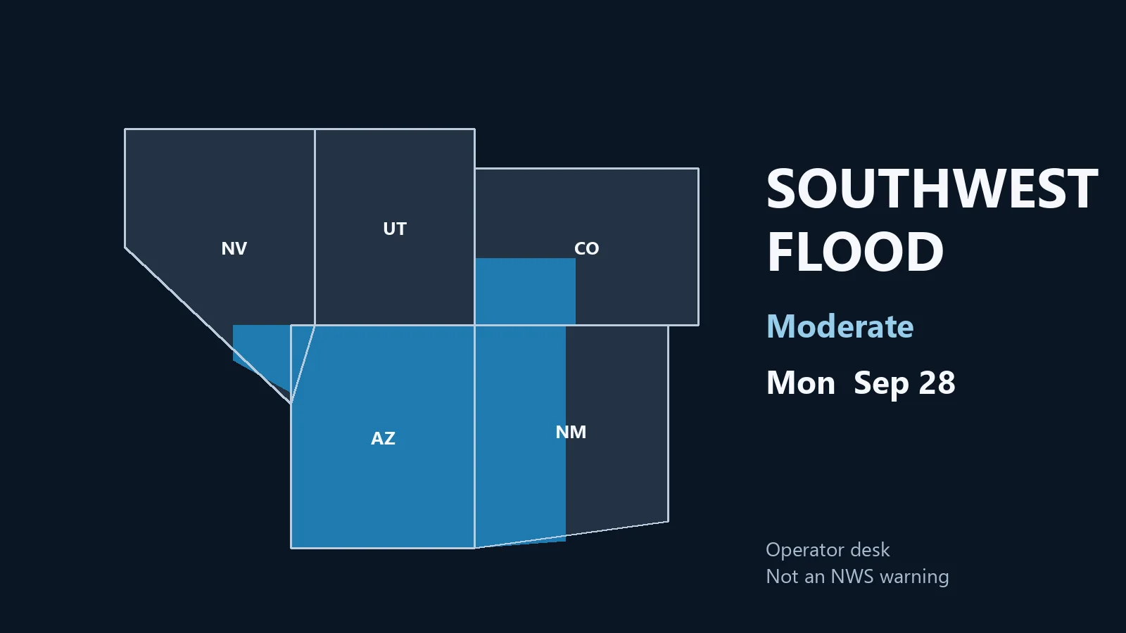
  • Storm Updates: Southwest Flood Moderate, Quiet Severe Pulse — Monday, September 28, 2026 (Morning)

    Storm Updates: Southwest Flood Moderate, Quiet Severe Pulse — Monday, September 28, 2026 (Morning)

    Map of Arizona, southern Nevada, southwest Colorado, and western New Mexico marked for Monday's moderate flood risk
    Monday morning desk. Moderate flood on the Southwest and Four Corners. Not an NWS warning.

    This is a live Monday morning snapshot of U.S. local-storm activity as of Monday, September 28, 2026. Overnight into this morning, the organized severe desk stayed quiet. The Storm Prediction Center 1300 UTC Day 1 Convective Outlook has no severe thunderstorm areas forecast. No convective watches are valid. The Weather Prediction Center holds a Moderate Risk of excessive rainfall over portions of the Southwest and Four Corners as tropical moisture associated with Hurricane Polo and remnants of Odalys lifts north into already wet ground.

    These are county- and ZIP-scale thunderstorms and flash-flood pulses, not a U.S. mainland hurricane landfall. Polo is still a major hurricane approaching Baja California Sur and Sonora. Restoration exposure today is water first in the Southwest, then isolated wind and hail cleanup from last night’s High Plains and north Texas cells. Conditions change fast. Verify with the National Weather Service for the specific county or ZIP before you roll.

    What is live this morning

    SPC language at 0728 AM CDT: severe thunderstorm probability remains low on Monday. Isolated to scattered storms are still expected later over the northern High Plains from western Nebraska into the Dakotas, and numerous showers and thunderstorms are expected across southeast California, southern Nevada, and western Arizona. Those corridors do not carry unconditional severe probabilities on this outlook. The last issued convective watch was number 0674; nothing is live now.

    WPC Day 1 excessive rainfall, issued 0812 UTC Monday and valid 12Z Monday through 12Z Tuesday, is the headline. A Moderate Risk covers portions of the Southwest and Four Corners. Guidance supports a widespread 1 to 3 inches across the region, with south- and west-facing slopes along the Mogollon Rim and the San Juans favored. Precipitable water is forecast 2 to 3.5 standard deviations above normal. Burn scars, rocky soils, and slot canyons locally raise the flood threat. The Moderate outline forks farther south in New Mexico toward the Lordsburg area and the Sacramento Mountains.

    A weakening cyclone near the southern New England coast still supports showers and occasional embedded thunder along the coast. Instability is weak. That is leftover nor’easter weather, not a new severe corridor.

    Hotspot 1 — Southwest and Four Corners flood Moderate

    This is today’s organized desk. Moisture from Polo and post-tropical Odalys is being drawn north ahead of a mid-level trough moving from the California Valleys toward the lower Colorado River Valley. Widespread clouds and weak mid-level lapse rates should keep most storms disorganized, but rainfall rates on saturated soils do not need a supercell to fail a crossing.

    Counties and terrain to watch: Mogollon Rim and higher terrain in Arizona; western and southwestern New Mexico including burn-scar drainages near Lordsburg; the San Juan Mountains and adjacent southwest Colorado; southern Nevada valleys that take runoff from steep slopes. WPC notes the Moderate continues into Tuesday over parts of the Southwest, central and southern Rockies, and southern High Plains.

    Restoration read: water first. Stage pumps, extractors, and sandbags on known flood ZIPs and burn-scar alluvial fans before the afternoon cores. Photograph crawlspaces and finished basements as soon as it is safe. Do not treat this as a wind event unless a local warning says otherwise.

    Hotspot 2 — Northern High Plains isolated storms

    SPC keeps general thunderstorms from western Nebraska north into North Dakota. A surface trough and modest 500–1500 J/kg CAPE later this afternoon could support isolated stronger cells. Uncertainty on location and intensity is why severe probabilities stayed off the map. A southerly low-level jet may keep elevated storms going tonight.

    That is the same family that produced last night’s Cherry County hail. Staff it as isolated hail and outflow, not a watch day.

    Hotspot 3 — Leftover Northeast coast and north Texas cleanup

    The coastal cyclone continues to weaken near southern New England. Showers and occasional thunder remain possible near the coast. Sunday’s High Wind Warnings on the Jersey Shore and Long Island are already off the morning board from yesterday’s afternoon desk. Treat remaining coastal work as leftover water and beach debris, not a new wind outbreak.

    North Texas had a short severe pulse last evening over Parker County. That is a just-hit ticket, not today’s outlook.

    Just hit

    SPC local storm reports for the 1200 UTC Sunday to 1159 UTC Monday window, all preliminary:

    • 2216 UTC — 1.00-inch hail 20 miles south of Merriman, Cherry County, Nebraska. Vehicle damage reported. (NWS North Platte)
    • 2330 UTC — 1.00-inch hail 2 miles north-northwest of Willow Park, Parker County, Texas. (NWS Fort Worth)
    • 0032 UTC — 1.00-inch hail 24 miles north of Whitman, Cherry County, Nebraska. (NWS North Platte)
    • 1440 UTC Sunday — 66 mph gust 10 miles northwest of Okobojo Creek Recreation Area, Sully County, South Dakota. Mesonet. (NWS Aberdeen)
    • 2300 UTC — 60 mph gust 22 miles west-southwest of Roosevelt, Sutton County, Texas. West Texas Mesonet Sonora 23SE. (NWS San Angelo)
    • 2320 UTC — Unknown-speed wind 4 miles north-northwest of Willow Park, Parker County, Texas. Large tree limbs down and outdoor items blown around on FM 730. (NWS Fort Worth)

    No tornado reports were received in that window. Severe Thunderstorm Warnings that fired Sunday evening over southwestern Cherry County, Nebraska, and northeastern Parker County, Texas, have expired.

    Pulse table

    RegionMain threatsSPC / NWS / WPC levelStatus this morning
    Southwest / Four CornersFlash flood, training heavy rain, burn-scar runoffWPC Moderate excessive rainfallLive outlook through Tuesday 12Z
    SE CA / southern NV / western AZNumerous showers and storms, isolated wet downburstGeneral thunder; no severe probsToday into evening
    Western NE into the DakotasIsolated strong storms, hail or gust possibleGeneral thunder; no severe probsLate afternoon–overnight
    Cherry County, NE / Parker County, TXQuarter hail, tree limbsExpired SVR / LSRsJust-hit cleanup
    Southern New England coastShowers, leftover coastal waterWeak cyclone; no severe areaFading
    Polo / OdalysMexico land and moisture feed, not CONUS landfallNHC Polo major hurricane near BajaMoisture into the Southwest

    What this means for restoration teams

    The national severe map is blank. That does not mean a quiet shop in Arizona, New Mexico, southwest Colorado, or southern Nevada. Moderate excessive-rainfall language on already wet soils is extraction, drying, and a 24–48 hour mold clock in finished space. Burn-scar fans fail first. Stage before the afternoon moisture surge, not after the first flash-flood warning.

    Cherry County and Willow Park are yesterday’s hail and limb tickets. Photograph vehicles and roofs in daylight if it is still safe. Sully County’s 66 mph mesonet gust and the Sutton County 60 mph gust are isolated wind, not a line.

    Polo is a Baja and Sonora hurricane desk plus a U.S. flood-moisture feed. Do not staff it as a California or Arizona landfalling hurricane.

    What this is not

    This is not a Slight or Enhanced severe day and not a U.S. mainland hurricane landfall. Work today, if it verifies, is flash flooding on the Four Corners Moderate and isolated High Plains cells. That is the local-storm pattern this desk should staff.

    Looking ahead

    WPC keeps Moderate excessive-rainfall language into Tuesday over parts of the Southwest, central and southern Rockies, and southern High Plains, then into the southern Plains midweek. SPC’s next Day 1 update is scheduled by 1630 UTC. Watch the afternoon Storm Tracker rather than assuming the blank severe map lasts past sunset.

    Sources and how to verify

    Primary sources: NOAA Storm Prediction Center Sep 28, 2026 1300 UTC Day 1 Convective Outlook; SPC Current Watches page (no watches valid); SPC local storm reports for 27/1200 UTC–28/1159 UTC; Weather Prediction Center Day 1 Excessive Rainfall Outlook issued 0812 UTC Mon Sep 28; National Hurricane Center advisories on Hurricane Polo and post-tropical Odalys; National Weather Service warning text compiled at weather.gov.

    Check weather.gov for the county warning, spc.noaa.gov for the outlook, watches, and LSRs, and WPC excessive rainfall for the flood overlay. Prior desk: Sunday afternoon Quiet Pulse, Northeast flood Slight.

    Informational only — not an official weather warning. Follow local authorities and the National Weather Service. Turn around, don’t drown.

  • Storm Updates: Mid-Atlantic High Wind, Southern Plains Marginal — Saturday, September 26, 2026 (Morning)

    Storm Updates: Mid-Atlantic High Wind, Southern Plains Marginal — Saturday, September 26, 2026 (Morning)

    This is a live Saturday morning snapshot of U.S. local-storm activity as of Saturday, September 26, 2026. Overnight into this morning, the organized severe desk stayed quiet: no Storm Prediction Center convective watches are valid. The 1300 UTC Day 1 Convective Outlook draws a Marginal Risk of isolated hail and strong outflow winds for western Oklahoma into northwest Texas late this afternoon into early evening. The Weather Prediction Center Day 1 Excessive Rainfall Outlook holds Slight Risk pockets from southwest Iowa into northern Missouri and along the Mid-Atlantic and southern New England coast, with a broader Marginal overlay from the southern Plains into the central Plains.

    The live work this morning is not a watch box. It is High Wind Warnings on the Mid-Atlantic and southern New England coast from a strengthening coastal low, leftover water in north-central Kansas where a flash-flood warning was replaced by a flood advisory, and a few overnight local storm reports. These are county-scale thunderstorms and coastal wind, not a U.S. mainland hurricane landfall. Restoration exposure today is wind-driven trees and service drops on the coast, isolated hail and outflow later on the southern Plains, and interior water where yesterday’s High Plains rain is still in the channel. Conditions change fast. Verify with the National Weather Service for the specific county or ZIP before you roll.

    What is live this morning

    SPC current watches: none. Most recently issued watch was 0674, already expired. The 0655 AM CDT Day 1 discussion (Smith/Bentley) is explicit: morning showers and thunderstorms over the southern High Plains should dissipate, with new storm development around 21–23 UTC (4–6 p.m. CDT). Isolated large hail and severe gusts are possible mainly 22z–02z. Elsewhere, SPC calls the severe environment quiescent.

    WPC valid 12Z Saturday through 12Z Sunday: Slight Risk of rainfall exceeding flash-flood guidance from roughly southwest Iowa into northern Missouri, and a second Slight along the Mid-Atlantic and southern New England coast from the Delmarva through Cape Cod and adjacent waters. A Marginal Risk covers a large southern-to-central Plains corridor plus a coastal Mid-Atlantic/Northeast swath.

    National Hurricane Center: Tropical Depression Fay and Tropical Storm Gonzalo are well out in the open Atlantic and are not a U.S. land threat this morning. Hurricane Nolo remains nearly stationary well south of the Big Island of Hawaii and is forecast to stay south of the islands; that is a Hawaii flood-and-wind desk, not a mainland landfall. Eastern Pacific Hurricanes Odalys and Polo are Mexico-waters storms, not CONUS landfalls.

    Hotspot 1 — Mid-Atlantic and southern New England high wind

    This is the live warning desk. National Weather Service Mount Holly holds a High Wind Warning until 6:00 a.m. EDT Sunday for Delaware beaches and coastal New Jersey counties including Eastern Monmouth, Atlantic Coastal Cape May, Coastal Atlantic, and Coastal Ocean. Language: north winds 30 to 40 mph with gusts up to 60 mph; trees and power lines; widespread outages possible. Boston/Norton holds High Wind Warnings until 8:00 a.m. EDT Sunday for eastern and southeastern Massachusetts and Rhode Island, with northeast gusts 50–60 mph on the exposed coast and 50 mph inland over Kent and Providence counties. WPC’s coastal Slight excessive-rainfall risk sits under the same system: heaviest totals preferred offshore, but localized heavy rain can still reach the Jersey Shore through southern New England.

    Cities and counties to watch: Atlantic City, Long Beach Island, Ocean City, Rehoboth Beach, Sandy Hook; Boston, Quincy, Plymouth, New Bedford, Cape Cod, Nantucket, Martha’s Vineyard; Providence, Warwick, Newport, Westerly.

    Restoration read: wind first. Stage tree crews, generators, and tarp kits before the next peak gust period tonight. Treat coastal ZIPs as possible interior-water jobs if the Slight rain overlay verifies on already-wet ground. Photograph roofs in remaining daylight only if it is safe.

    Hotspot 2 — Western Oklahoma into northwest Texas (afternoon Marginal)

    SPC’s only categorical severe area today. A High Plains upper trough and a smaller-scale jet over the Texas Panhandle into Oklahoma maintain a lee trough and dewpoints in the lower to mid 60s. Morning convection is expected to die. New storms 21–23 UTC from south-central Kansas through western Oklahoma and west/northwest Texas. Adequately strong deep-layer shear supports a few organized cells capable of isolated large hail and severe outflow, mainly 22z–02z. Lubbock’s hazardous-weather outlook already flags isolated afternoon and evening storms off the Caprock with gusts to 65 mph and hail to quarter size.

    Restoration read: this is a late-day hail and wind ticket, not a morning watch. Do not pre-position as if a Slight or Enhanced is up. Staff local warnings if they fire after 4 p.m. CDT.

    Hotspot 3 — Leftover High Plains water and central Plains flood overlay

    NWS Hastings replaced a flash-flood warning with a Flood Advisory through 1:00 p.m. CDT for parts of Jewell, Mitchell, Osborne, and Smith Counties in north-central Kansas. That is yesterday’s rain still in the ditch, not a new MCS. WPC keeps a Slight excessive-rainfall risk over southwest Iowa into northern Missouri and a Marginal from Oklahoma and West Texas north across Kansas toward the eastern Dakotas. Friday afternoon’s New Mexico flood pulse is no longer the national Slight; treat Cibola and Santa Fe as aftermath unless a new warning posts.

    Great Falls holds a High Wind Warning until noon MDT for Glacier, Toole, and Pondera High Plains zones — westerly 30–50 mph, gusts to 70. That is a plains wind event, not the SPC Marginal.

    Just hit

    Overnight and Friday evening local storm reports, all preliminary: landspout near Wilmore in Comanche County, Kansas; one-inch hail that cracked windshields at Tecolote and near Romeroville in San Miguel County, New Mexico; 59–61 mph measured gusts in Liberty and Pondera Counties, Montana. Earlier Friday into last night on the Texas side of the same High Plains corridor: 60 mph at Memphis in Hall County, an estimated 60 mph north of Study Butte, and a roof section blown onto a road in Terlingua, Brewster County. No tornado watch fired. No convective watch is live this morning.

    Pulse table

    RegionMain threatsSPC / NWS / WPC levelStatus this morning
    Coastal NJ / DE / southern New EnglandDamaging wind, trees, outages, localized heavy rainHigh Wind Warning + WPC Slight (coast)Live warnings through Sunday morning
    Western OK / northwest TX / south-central KSIsolated hail, severe outflowSPC Marginal 22z–02zAfternoon–evening development
    SW Iowa / northern MissouriTraining rain, flash floodWPC SlightToday into tonight
    North-central Kansas (Jewell–Smith)Residual floodingFlood Advisory to 1 p.m. CDTAftermath / still in channel
    Northern MT High PlainsHigh wind gusts to 70 mphHigh Wind Warning to noon MDTLive, expires midday
    Hawaii (Nolo)Flood watch Big Island / Maui CountyNHC hurricane well south of islandsHawaii desk only
    U.S. mainland tropicalNo landfalling hurricaneFay / Gonzalo open AtlanticQuiet on the mainland coast

    What this means for restoration teams

    Coastal gusts of 50–60 mph are tree-on-structure, siding, gutter, and service-drop work. Stage before dark on the Jersey Shore and southern New England, not after the first outage ticket. The Oklahoma–Texas Marginal is a late-day hail and wind desk: a few cells, not a regional outbreak. Kansas flood-advisory counties are already wet — extraction and drying, not a new watch. Hawaii Nolo stays off the mainland board.

    Property owners: photograph damage in daylight if it is safe, call the carrier, and start extraction the same night if water is inside. Turn around, don’t drown at low-water crossings in the WPC Slight counties.

    What this is not

    This is not a regional derecho and not a U.S. mainland hurricane landfall. No convective watch is up. The work today, if it comes, will be scattered: a coastal wind swath through a New Jersey or Massachusetts county, a late-day hail core in western Oklahoma, leftover water in a Kansas creek. That is the local-storm pattern this desk should staff.

    Looking ahead

    Coastal High Wind Warnings run through early Sunday. The southern Plains Marginal is a same-day afternoon problem, not an overnight watch. SPC Day 2 language on the hazard matrix is No Severe for Sunday. Watch the next Storm Tracker update rather than assuming this morning’s High Wind Warning is the last line of the weekend.

    Sources and how to verify

    Primary sources: NOAA Storm Prediction Center Sep 26, 2026 1300 UTC Day 1 Convective Outlook; SPC current watches (none valid); SPC local storm reports for 1200 UTC Sep 25–1159 UTC Sep 26; Weather Prediction Center Day 1 Excessive Rainfall Outlook valid 12Z Sep 26–12Z Sep 27; National Weather Service warning text from Mount Holly, Boston/Norton, Great Falls, Hastings, and Lubbock; National Hurricane Center public advisories for Nolo, Fay, and Gonzalo. Check weather.gov for the county warning, spc.noaa.gov for the outlook, watches, and LSRs, and WPC excessive rainfall for the flood overlay. Prior desk: Friday, September 25 afternoon Storm Updates.

    Informational only — not an official weather warning. Follow local authorities and the National Weather Service. Turn around, don’t drown.

  • Storm Updates: Southern High Plains Flood Slight, Quiet Severe Day — Friday, September 25, 2026 (Morning)

    This is a live Friday morning snapshot of local storm-type events across the United States as of the morning of Friday, September 25, 2026. The organized desk is still water on the southern High Plains, not a national wind outbreak. The Storm Prediction Center 1300 UTC Day 1 Convective Outlook, valid 251300Z–261200Z, carries no severe thunderstorm areas. Summary language from Norman: organized severe thunderstorms are not expected today. The Weather Prediction Center 12Z Day 1 Excessive Rainfall Outlook, valid 12Z Friday through 12Z Saturday, holds a Slight Risk of excessive rainfall across portions of the southern High Plains — southeast New Mexico into the Texas Panhandle and parts of West Texas.

    These are county- and ZIP-scale thunderstorms and leftover runoff, not a U.S. mainland hurricane landfall. Restoration exposure this morning is water already in low crossings and buildings from last night’s New Mexico–west Texas MCS, plus isolated heavy rain if cells redevelop this afternoon. Conditions change fast. Verify with the National Weather Service for the specific county or ZIP before you roll.

    What is live this morning

    No tornado or severe thunderstorm watches are current. The SPC watch page, updated 1300 UTC Friday, states no watches are valid. The last issued convective watch on the board is Watch 674, already expired. Yesterday evening’s 0100 UTC Day 1 outlook had carried a Marginal Risk over parts of the Texas Panhandle; that window closed overnight. Today’s 1300 UTC package dropped categorical severe probabilities entirely.

    Overnight flash-flood warnings from Midland/Odessa, Albuquerque, and El Paso/Santa Teresa covered northwestern Eddy County, southwestern Chaves County, and central Otero County in New Mexico, plus southeastern El Paso County and parts of Hudspeth County in western Texas. Those products were valid into the predawn hours — Eddy and Chaves until 530 AM MDT, Otero until 730 AM MDT, El Paso extensions into 330–445 AM MDT. By this morning desk they have expired. That is the just-hit pile, not a live warning overlay.

    Hotspot 1 — Southeast New Mexico into the Texas Panhandle and West Texas

    This is today’s flood ticket, trimmed from Thursday’s Moderate. WPC’s 410 AM EDT Friday discussion keeps a Slight Risk from southeastern New Mexico to the southern Panhandle and extends it south into parts of West Texas, where 3-hour flash-flood guidance is under an inch. Overnight activity over eastern New Mexico and the Texas Panhandle can still produce additional flooding concerns into mid to late morning. Guidance then has storms diminishing as the shortwave and deeper moisture lift northeast. Afternoon cells over West Texas can still dump 1–2 inches locally on already wet ground.

    SPC’s Day 1 discussion notes a convectively modified disturbance over eastern New Mexico lifting toward the central High Plains, mid- and high-level clouds over western Oklahoma, and only a low-probability severe gust if a stronger storm develops late this afternoon in western Oklahoma. Southern New Mexico, in the wake of the early-day MCS, may see a couple of stronger cells with some hail risk, but confidence in a severe-caliber threat is low. That is why there is no categorical severe area this morning.

    Cities and counties to watch: Artesia, Hope, Lakewood, and Brantley Lake in Eddy County; Dunken and Elk in southwestern Chaves; Sacramento, Mayhill, and Weed in Otero; Tornillo, Hueco Tanks, and rural east-central El Paso and Hudspeth Counties. Streams named in overnight warning text include the Rio Penasco, Bluewater Creek, and Agua Chiquita Creek.

    Restoration read: water first. Extraction and drying on structures that took overnight runoff. Low-water crossings and rural roads in the Sacramento Mountains and Pecos Valley stay a drive-around, not a drive-through. Stage pumps where last night’s warnings sat. Do not treat this as a wind event.

    Hotspot 2 — Western Oklahoma scatter

    SPC leaves the door cracked for a stronger storm or two late this afternoon over western Oklahoma under modest mid-level lapse rates and up to about 1500 J/kg MLCAPE, with a low-probability severe gust. Cloud cover from the departing MCS and tropical-origin moisture aloft will limit heating. This is not a watch candidate at 1300 UTC. Treat it as isolated outflow and lightning, not a Plains outbreak.

    Hotspot 3 — Hurricane Nolo, Big Island of Hawaii

    The National Hurricane Center and Central Pacific Hurricane Center are issuing advisories on Hurricane Nolo. As of the 200 AM HST Friday advisory, Nolo was near 15.8°N 155.6°W, moving north-northeast at 5 mph, with maximum sustained winds of 85 mph and a minimum pressure of 980 mb. Headline language: catastrophic and life-threatening flash flooding possible on the Big Island of Hawaii into the weekend. Local NWS Honolulu products own the island warning suite. This is a Hawaii County flood-and-wind desk, not a CONUS landfall. Fay and Gonzalo in the Atlantic and Odalys and Polo in the eastern Pacific are not U.S. mainland land threats this morning.

    Just hit

    SPC today’s storm reports for the 1200 UTC September 24 through 1159 UTC September 25 window show no tornado reports and no hail reports as of this desk. One preliminary wind report: 60 mph at Memphis in Hall County, Texas, at 1758 UTC Thursday, relayed by NWS Lubbock. That is yesterday afternoon’s High Plains Marginal, not a new overnight severe pile.

    The overnight work that did verify is water. NWS Midland issued a flash-flood warning for northwestern Eddy County until 530 AM MDT covering Artesia, Hope, Seven Rivers, Brantley Lake, Dayton, Lakewood, and Atoka. Albuquerque warned southwestern Chaves County until 530 AM MDT for Dunken and Elk, with considerable damage-threat language on the Rio Penasco and Bluewater Creek. El Paso/Santa Teresa warned central Otero County until 730 AM MDT for Sacramento, Mayhill, Weed, and several canyons, and separately warned pieces of El Paso and Hudspeth Counties where 1 to 3 inches had already fallen. Those warnings are expired this morning. Survey and extraction replace the warning overlay.

    Pulse table

    RegionMain threatsSPC / NWS / WPC levelStatus this morning
    SE NM / TX Panhandle / West TexasFlash flood, leftover runoff, isolated heavy rainWPC Slight excessive rainfallOvernight FFWs expired; Slight still live
    Western OK / southern NM cellsIsolated gust or hail, low confidenceSPC 1300 UTC: no categorical areaAfternoon scatter only
    Hall County, TX (Memphis)60 mph wind Thursday afternoonYesterday Marginal LSRJust-hit / closed
    Big Island, HawaiiFlash flood, tropical windHurricane Nolo, 85 mphLive Hawaii desk
    CONUS severe watchesNoneNo watches valid; last was 674Quiet

    What this means for restoration teams

    Friday is a Quiet Pulse on the severe side and a water desk on the southern High Plains. Overnight flash flooding in Eddy, Chaves, Otero, El Paso, and Hudspeth Counties is the work that already happened. Interior water starts a 24–48 hour mold clock. Photograph in daylight if it is safe. Do not drive flooded crossings in the Sacramento Mountains or the Pecos Valley.

    Western Oklahoma and southern New Mexico may still fire isolated strong cells this afternoon. Staff that as local lightning and a possible isolated gust or hail stone, not a regional wind swath. Hawaii County is a separate tropical-flood ticket under Nolo. Do not mix that crew map with the New Mexico overnight pile.

    What this is not

    This is not a regional derecho and not a U.S. mainland hurricane landfall. SPC has no Day 1 severe area. No convective watch is up. Thursday’s Moderate flood risk over southeast New Mexico has been stepped down to a Slight. The work this morning is leftover water and a trimmed rainfall overlay. That is the local-storm pattern this desk should staff.

    Looking ahead

    The SPC 0600 UTC Day 2 Convective Outlook, valid 261200Z–271200Z Saturday, carries a Marginal Risk of severe thunderstorms for portions of the central and southern Plains. Summary: isolated hail and damaging winds may accompany a few strong to severe thunderstorms Saturday from parts of Kansas into western Texas and Oklahoma, including the Wichita-to-Lubbock corridor. Watch the afternoon Storm Tracker rather than treating Friday’s quiet severe map as the weekend map.

    Sources and how to verify

    Primary sources: NOAA Storm Prediction Center 1300 UTC Day 1 Convective Outlook for Friday, September 25, 2026; SPC current watch page (no watches valid; last issued Watch 674); SPC storm reports for 1200 UTC September 24 through 1159 UTC September 25; Weather Prediction Center Day 1 Excessive Rainfall Outlook discussion issued 410 AM EDT Friday; National Weather Service flash-flood warning text from Midland/Odessa, Albuquerque, and El Paso/Santa Teresa overnight; National Hurricane Center / Central Pacific Hurricane Center advisory on Hurricane Nolo at 200 AM HST Friday.

    Check weather.gov for the county warning, spc.noaa.gov for the outlook, watch, and LSRs, and WPC excessive rainfall for the flood overlay. Prior desk: Thursday afternoon, September 24 storm updates.

    Informational only — not an official weather warning. Follow local authorities and the National Weather Service. Turn around, don’t drown.

  • Storm Updates: New Mexico–Plains Flood Slight, Dakotas Hail Pulse — Thursday, September 24, 2026 (Morning)

    This is a live Thursday morning snapshot of local storm-type events across the United States as of the morning of Thursday, September 24, 2026. Overnight into this morning, the organized severe corridor from Wednesday’s western Dakotas Marginal Risk did verify on the Local Storm Report board — a brief tornado west of Hettinger and baseball-size hail near South Heart, North Dakota. Convective watches are not currently valid. The Storm Prediction Center 0600 UTC Day 1 Convective Outlook, valid 241200Z–251200Z, carries no categorical severe thunderstorm areas. Isolated stronger storms with hail or gusty winds remain possible late this afternoon and early evening from southeast Arizona and southern New Mexico into the Texas Panhandle and western Oklahoma and Kansas.

    The water desk is still the national headline, not wind. Weather Prediction Center short-range language this morning keeps a Slight Risk of excessive rainfall over portions of New Mexico into the south-central Plains, with a broader Marginal Risk from the Four Corners into the central Plains as leftover tropical moisture and embedded shortwaves keep training cells possible on already wet ground. These are county- and ZIP-scale thunderstorms and flash-flood pulses, not a U.S. mainland hurricane landfall. Restoration exposure today is leftover water in New Mexico and the southern High Plains, isolated hail and wind on the Dakotas just-hit pile, and a Hawaii watch for Tropical Storm Nolo well south of the Big Island.

    Conditions change fast. Verify with the National Weather Service for the specific county or ZIP before you roll.

    What is live this morning

    No Storm Prediction Center convective watches are currently valid. The most recently issued watch on the SPC board is Severe Thunderstorm Watch 674, a Sunday-night eastern Colorado and western Kansas product that expired days ago. Yesterday’s western Dakotas and southern Appalachians Marginal Risk is off the Day 1 map. The 0600 UTC discussion from Guyer and Thornton is plain: organized severe thunderstorms are unlikely today and tonight. The same discussion still flags pockets of moderate destabilization into peak heating across southeast Arizona, southern New Mexico, and the southern High Plains.

    The SPC overview hazard matrix later this morning lists Thursday as a Marginal severe day. Treat that as the later-cycle read against the published 0600 UTC text of “no severe thunderstorm areas forecast.” Either way, this is not a watch morning. Isolated hail or a damaging gust is the ceiling unless a new outlook or mesoscale discussion draws a tighter box this afternoon.

    On the flood side, Wednesday’s Weather Prediction Center Day 1 Moderate Risk over the Texas and Oklahoma Panhandles and central and eastern New Mexico has rolled off the valid window. Thursday language from WPC’s short-range public discussion is a step down: Slight Risk of excessive rainfall over portions of New Mexico into portions of the south-central Plains, Marginal Risk across much of the Four Corners into the central Plains. Soils are still saturated. Rates, not coverage, are the problem if a cell trains.

    Hotspot 1 — New Mexico into the Texas and Oklahoma Panhandles and western Kansas

    This remains the water desk. Overnight, National Weather Service Dodge City issued a Flash Flood Warning for northwestern Grant, southeastern Hamilton, western Kearny, northeastern Morton, and eastern Stanton Counties in southwestern Kansas until 5:00 a.m. CDT. Radar-indicated totals of 2 to 3 inches were already on the ground at issuance, with another 1 to 2 inches possible. That warning is off the clock this morning. It is the signature of the same moisture plume that spent midweek over New Mexico.

    WPC still expects scattered showers and thunderstorms Thursday as large-scale forcing weakens but instability and embedded shortwave energy remain. Portions of New Mexico and Texas stay sensitive because of the multi-day rain. Localized 1-inch-per-hour rates on burn scars, arroyos, urban streets, and low water crossings are the first failures. A separate, lower-coverage pulse is possible in southeast Arizona under the same southwesterly mid-level flow.

    Restoration read: extraction and drying on buildings that took water Tuesday and Wednesday, plus a new poor-drainage ticket if a cell parks on a ZIP that already failed. Do not treat the whole Moderate-Risk footprint from yesterday as still live. Staff the county that still has a warning, not the outline from Wednesday afternoon.

    Hotspot 2 — Western North Dakota just-hit pile

    Wednesday afternoon’s western Dakotas Marginal Risk produced the overnight LSR pile. Preliminary Storm Prediction Center reports for the 1200 UTC September 23 through 1159 UTC September 24 window include:

    • A brief tornado around 2236 UTC about 3 miles south-southwest of Bucyrus in Adams County, North Dakota, based on social-media video and radar, west of Hettinger. NWS Bismarck logged the location as approximate.
    • Quarter-size hail (1.00 inch) at New England, Hettinger County, at 2307 UTC.
    • Half-dollar hail (1.25 inches) about 3 miles southeast of Belfield, Stark County, at 2340 UTC.
    • Baseball-size hail (2.75 inches) about 2 miles southwest of South Heart, Stark County, at 2345 UTC.

    Those are official preliminary LSRs, not social rumor. Hail that size breaks windows, dents siding, and wrecks HVAC fins. The tornado report is a one-minute touchdown, not a long-track event. Restoration work there is already a survey-and-tarp job, not a new watch.

    Hotspot 3 — Southern High Plains scatter plus leftover wind reports

    SPC’s Day 1 discussion leaves the door open for a few stronger, locally severe storms late this afternoon and early evening from southeast Arizona and southern New Mexico into the Texas Panhandle and western Oklahoma and Kansas. That is isolated hail and gusty outflow, not a Slight Risk corridor. Yesterday’s board also carries a 58 mph thunderstorm gust 4 miles southeast of Frederick in Tillman County, Oklahoma, at 2158 UTC, and a tree down in Van Wert, Polk County, Georgia, at 2000 UTC. Those are scatter, not a line.

    Farther east, an amplifying coastal low off the Mid-Atlantic and New England is a marine and coastal-flood story, not a convective watch. WPC flags coastal flooding, rip currents, and heavy rain along the East Coast into the weekend. That is a different desk from the New Mexico flood pulse.

    Tropical — Nolo south of Hawaii, not a mainland landfall

    Central Pacific Hurricane Center is issuing advisories on Tropical Storm Nolo. As of 2:00 a.m. HST Thursday, Nolo was about 285 miles south of South Point, Hawaii, and about 460 miles south-southeast of Honolulu, stationary, with maximum sustained winds near 50 mph and a minimum pressure of 999 mb. Official language: Nolo is forecast to intensify into a hurricane late today and could become a major hurricane by the weekend. That is a Hawaii County and offshore-waters problem, not a Gulf or East Coast landfall. Hurricane Polo and Hurricane Odalys remain in the eastern Pacific off Mexico. Tropical Storm Fay is in the open Atlantic well west-southwest of the Azores and is not a U.S. land threat.

    Just hit

    Wednesday’s live desk was still water over central and eastern New Mexico, with SPC trimmed to a western Dakotas Marginal. That Dakotas box verified overnight on hail and a brief tornado. The New Mexico Moderate flood risk has stepped down to Slight into the south-central Plains. Southwestern Kansas took a late-night flash-flood warning that expired at 5:00 a.m. CDT. No new convective watch fired overnight. Watch 674 is not today’s product.

    Pulse table

    RegionMain threatsSPC / NWS / WPC levelStatus this morning
    NM into TX/OK Panhandles and western KSFlash flood, training heavy rainWPC Slight excessive rainfallLive flood overlay; KS FFW expired 5 a.m. CDT
    SE AZ / southern NM / southern High PlainsIsolated hail, gusty wind, heavy rainSPC 0600 UTC: no categorical area; isolated stronger storms possibleAfternoon–evening scatter
    Western ND (Hettinger / Stark)Hail damage, brief tornadoYesterday Marginal; LSRs inJust-hit / survey
    Four Corners to central PlainsIsolated heavy rainWPC Marginal excessive rainfallDiurnal cells
    East Coast marine / New England coastCoastal flood, wind, heavy rainWPC / OPC coastal lowNot a convective watch
    Hawaii — NoloTropical storm to hurricane risk south of the islandsCPHC TS Nolo, 50 mphWatch Hawaii products, not mainland
    Atlantic / Gulf vs. U.S. mainlandNo landfalling hurricaneQuiet on the mainland coastQuiet

    What this means for restoration teams

    New Mexico and the southern High Plains are still a water week. Saturated ground plus another Slight Risk means the next training cell is a wet-drywall and crawlspace ticket, not a surprise. Photograph and extract what already flooded before you chase a new ZIP. Southwestern Kansas counties that sat under last night’s warning should be treated as just-hit poor-drainage work until local offices drop the flood language.

    Western North Dakota is a hail desk. Baseball stone southwest of South Heart is broken glass and bruised roofs. The Adams County tornado report is a narrow path. Staff it as a local damage survey. Do not read “tornado” on an LSR board as a regional event.

    If the later SPC cycle firms a Marginal box over the southern High Plains, the work is still isolated hail and outflow, not a watch. Stage tarps only where a warning is live. Hawaii shops should follow Central Pacific Hurricane Center products on Nolo, not this CONUS flood pulse.

    What this is not

    This is not a regional derecho and not a U.S. mainland hurricane landfall. Polo and Odalys are eastern Pacific storms off Mexico. Fay is mid-Atlantic open water. Nolo is a Central Pacific storm still south of the Big Island. The CONUS work this morning is leftover flood water, a North Dakota hail pile, and a quiet watch board.

    Looking ahead

    SPC Day 2, valid Friday, currently carries no severe thunderstorm areas. WPC still sees the moisture axis shifting east Friday into the south-central Plains and Midwest with another heavy-rain overlay possible. SPC Day 3 language returns a Marginal Risk later in the weekend as an upper trough works the central United States. Watch the afternoon Storm Tracker rather than assuming Thursday’s quiet watch board is the last line of the week.

    Sources and how to verify

    Primary sources: NOAA Storm Prediction Center 0600 UTC Day 1 Convective Outlook for Thursday, September 24, 2026; SPC current watches page (no watches valid as of 0705 UTC); SPC today’s storm reports for 20260923 1200 UTC–20260924 1159 UTC; Weather Prediction Center Day 1 Excessive Rainfall Outlook and short-range public discussion valid 12Z Thursday through 12Z Saturday; National Weather Service Dodge City flash-flood warning text for southwestern Kansas; Central Pacific Hurricane Center / National Hurricane Center public products on Tropical Storm Nolo as of 2:00 a.m. HST Thursday.

    Check weather.gov for the county warning, spc.noaa.gov for the outlook, watch, and LSRs, and WPC excessive rainfall for the flood overlay. Prior desk: Storm Updates: New Mexico Flood Moderate, Western Dakotas Marginal — Wednesday, September 23, 2026.

    Informational only — not an official weather warning. Follow local authorities and the National Weather Service. Turn around, don’t drown.

  • Storm Updates: New Mexico Flood Moderate, Dakotas–Appalachians Marginal — Wednesday, September 23, 2026 (Morning)

    This is a live Wednesday morning snapshot of local storm-type events across the United States as of the morning of Wednesday, September 23, 2026. Overnight into this morning, the flood desk ran ahead of the severe desk: National Weather Service flash-flood warnings for El Paso County, Texas; Amelia, Cumberland, and Powhatan counties in central Virginia; and a receding western North Carolina pulse around Lake Lure / Bat Cave / Chimney Rock. Those overnight warnings are treated as expired or expiring into this morning. Today’s desks: Storm Prediction Center Marginal Risk for parts of the western Dakotas and the southern Appalachians; Weather Prediction Center Moderate Risk of excessive rainfall across portions of central and eastern New Mexico. No convective watches are currently valid.

    These are county- and ZIP-scale thunderstorms and flood pulses, not a U.S. mainland hurricane landfall. There is no named tropical cyclone threatening U.S. land in the current National Hurricane Center picture. Restoration exposure today into tonight is water first in New Mexico and far west Texas, leftover street and creek flooding in central Virginia and the southern Appalachians, and isolated damaging gusts this afternoon if the two Marginal corridors heat. Conditions change fast. Verify with the National Weather Service for the specific county or ZIP before you roll.

    What is live this morning

    SPC’s 1300 UTC Day 1 Convective Outlook (issued 7:26 a.m. CDT Wednesday, September 23, 2026; Smith/Mead; valid 231300Z–241200Z) places a Marginal Risk over parts of the western Dakotas and the southern Appalachians. Summary: isolated severe thunderstorms are possible this afternoon across those two corridors. Western Dakotas: mid-level trough moving out of Wyoming/Montana, lee trough, moisture plume off the High Plains, around 1,000 J/kg MLCAPE, isolated marginally severe hail or gusts through early evening. Southern Appalachians: mid-level vorticity maximum sliding southeast from the lower Ohio Valley; dewpoints in the 60s °F; 250–750 J/kg MLCAPE if heating wins against low cloud; strong to locally damaging gusts with the stronger cells. Hail probabilities were removed after the 12 UTC Nashville sounding showed poor 700–500 mb lapse rates (4.8 °C/km).

    No convective watches were currently valid as of the SPC watches page update at 09:44:06 UTC Wednesday, September 23, 2026. Most recent watch on the board: 0674. Check spc.noaa.gov/products/watch before you stage.

    WPC’s Day 1 Excessive Rainfall Outlook (updated 0832 UTC Wednesday, September 23, 2026; Chenard; valid 12Z Wed–12Z Thu) holds a Moderate Risk across portions of central and eastern New Mexico. Scattered to numerous flash floods are expected; locally significant and life-threatening impacts remain possible on sensitive terrain, urban drainage, and burn scars. A widespread 1–2 inches is generally expected, with localized 2–4 inch swaths likely on top of rain that already fell before 12Z. The Slight risk extends into southeast Arizona and a slice of far west Texas if storms propagate east. Separate flood desks: Slight over portions of eastern Kentucky, eastern Tennessee, and far western North Carolina; Marginal from Ohio into West Virginia and western Virginia/North Carolina; Marginal over south Florida.

    Hotspot 1 — Central and eastern New Mexico / far west Texas

    Today’s Moderate flood desk and the national headline. A well-defined mid-level shortwave lifts north-northeast across New Mexico with robust upper divergence and the chance of a weak surface low. Cloud cover is the limiter; daytime heating on the eastern edge of the rain shield plus easterly upslope should still support training cells in deep southerly flow. HREF/REFS neighborhood probabilities of more than 3 inches run 40–70% across the eastern half of the Moderate area. Overnight El Paso County already took radar-indicated 0.5–1.5 inch bursts and flash-flood warnings that expired before dawn.

    Restoration read: water first. Stage pumps and air movers before the afternoon/evening cores organize. Burn-scar runoff and arroyos fail first. Start extraction the same night if water is inside. Turn around, don’t drown — most flood deaths are in vehicles.

    Hotspot 2 — Southern Appalachians / eastern Tennessee

    Dual desk: SPC Marginal for isolated damaging gusts, WPC Slight for flash flood on wet ground from eastern Kentucky through eastern Tennessee into far western North Carolina. Extensive low cloud this morning is the uncertainty. If breaks allow 250–750 J/kg MLCAPE, multicells along the inverted trough can put down strong gusts around peak heating. HREF/REFS neighborhood flash-flood-guidance exceedance peaks over eastern Tennessee (above 40% in spots). Overnight, NWS Greenville-Spartanburg held a flash-flood warning into 5:45 a.m. EDT for southeastern Buncombe, northeastern Henderson, southwestern McDowell, northwestern Polk, and northwestern Rutherford counties — 2.5–4 inches already down, waters receding by 3:05 a.m. EDT, Rocky Broad near Bat Cave falling through 6.58 feet.

    Restoration read: leftover water plus a second-chance afternoon pulse. Do not treat receding creeks as closed. Stage extractors in eastern Tennessee and western North Carolina; tree and tarp crews only if the gusty cells actually fire.

    Hotspot 3 — Western Dakotas

    New SPC Marginal added on the 1300 UTC outlook. Mid-level trough crossing Wyoming/Montana reaches the western Dakotas late afternoon and deamplifies toward the Red River Valley by Thursday morning. Lee trough holds a moisture plume north from the central High Plains. Widely scattered storms near the Black Hills and lee trough this afternoon; isolated marginally severe hail or gusts through early evening. No major population centers sit inside the 5% hail contour.

    Restoration read: isolated wind and hail, not a regional outbreak. Stage only if you already work the Black Hills / western Dakota corridor. Do not pull crews off the New Mexico water desk for this.

    Just hit

    Overnight flood, not overnight severe. NWS El Paso/Santa Teresa issued flash-flood warnings for northwestern and central El Paso County into the small hours (radar 0.5–1.5 inches, additional 0.5–1 inch possible; warnings through 3:15 a.m. MDT). Otero Mesa / northwest of Dell City had 2.5–3 inches radar-estimated earlier in the night with rural-road flooding held off Dell City by retention dams. NWS Wakefield: up to 4 inches since 11 p.m. in northwestern Amelia County and up to 5.5 inches since 10 p.m. in western Powhatan County; warnings through 4:00–5:30 a.m. EDT. Western North Carolina pulse receding after 2.5–4 inches.

    SPC local storm reports for the 22/1200Z–23/1159Z window carried no tornado and no hail. Wind reports from late Tuesday afternoon remain on the board for Lauderdale County, Alabama (Lexington / Rogersville): power lines down, a brush fire, and a power pole/lines on a vehicle — already noted on yesterday’s afternoon Tygart Media desk. Do not invent additional LSR points.

    Pulse table

    RegionMain threatsSPC / WPC / NWS levelStatus this morning
    Central / eastern NM and far west TXFlash flood, training storms, burn-scar runoffWPC ModerateLive flood desk today–Thu 12Z
    Southeast AZLocalized flash floodWPC SlightToday
    Eastern KY / eastern TN / far western NCFlash flood + isolated damaging gustsWPC Slight + SPC MarginalAfternoon–evening
    Western Dakotas / Black HillsIsolated hail / gustsSPC MarginalLate afternoon–early evening
    OH into WV / western VA–NCLocalized flash flood on wet soilsWPC MarginalToday
    South FloridaUrban flash floodWPC MarginalLocal
    El Paso / central VA / WNC overnightFlash flood (expired/expiring FFWs)Overnight NWS warningsAftermath / receding
    U.S. mainland tropicsNo landfalling named cycloneNHC quiet for CONUS landQuiet

    What this means for restoration teams

    New Mexico and far west Texas remain water jobs if the Moderate risk verifies — extraction, drying, and a 24–48 hour mold clock. Central Virginia and western North Carolina are aftermath from last night plus a second-chance flood axis this afternoon in eastern Tennessee. The Dakotas Marginal is isolated. Do not treat receding overnight warnings as a closed book; soils are primed. Stage before the New Mexico afternoon cores. Start extraction the same night if water is inside. Turn around, don’t drown.

    What this is not

    This is not a regional derecho and not a U.S. mainland hurricane landfall. There are no tropical cyclones in the Atlantic basin at this hour. Hurricane Polo (Category 4, off southwest Mexico) and Hurricane Odalys (eastern Pacific, well west of Baja) are not CONUS land threats today. Tropical Depression Fifteen-E is a Central Pacific system near Hawaii, not a mainland U.S. landfall. Today’s work, if it verifies, is scattered: New Mexico flash flood, leftover Mid-Atlantic and Appalachian water, isolated Dakotas hail/wind, isolated southern Appalachian gusts.

    Looking ahead

    SPC Day 2 (Thursday) and Day 3 currently show no severe thunderstorm areas. That does not cancel today’s New Mexico flood problem or this afternoon’s two Marginal corridors. Day 4–8 language is only a possible localized Plains/Mid-Mississippi threat next Monday–Wednesday with weak shear — too unclear for probabilities. Watch the next Storm Tracker update rather than assuming the Moderate rainfall risk is the last line of the week.

    Sources and how to verify

    Primary sources: SPC Day 1 Convective Outlook issued 7:26 a.m. CDT Wednesday, September 23, 2026 (Smith/Mead); SPC watches page updated 09:44:06 UTC Wednesday, September 23, 2026; WPC Day 1 Excessive Rainfall Outlook updated 0832 UTC Wednesday, September 23, 2026 (Chenard); NWS El Paso/Santa Teresa, Wakefield, and Greenville-Spartanburg flash-flood products overnight; SPC local storm reports (Lauderdale County, Alabama wind from Tuesday afternoon); NHC Atlantic discussion 1215 UTC Wednesday, September 23, 2026.

    Check weather.gov for the county warning, spc.noaa.gov for the outlook, watch, and local storm reports, and WPC excessive rainfall for the flood overlay. Prior desk: Storm Updates September 22, 2026 — New Mexico Flood Moderate, Utah–Southeast Marginal.

    Informational only — not an official weather warning. Follow local authorities and the National Weather Service. Turn around, don’t drown.

  • Storm Updates: New Mexico Flood Moderate, Utah–Southeast Marginal — Tuesday, September 22, 2026 (Morning)

    This is a live Tuesday morning snapshot of local storm-type events across the United States as of the morning of Tuesday, September 22, 2026. Overnight, the Appalachians–Southeast corridor carried the pulse — NWS Charleston, West Virginia flash-flood warnings for southern and north-central West Virginia into southwest Virginia. Those overnight warnings are treated as expired/expiring into this morning (no active WV flash-flood warnings on the NWS alert feed at hang time). Today’s desks: Storm Prediction Center Marginal Risk for much of Utah into adjacent Wyoming and Colorado, plus a portion of the Southeast; Weather Prediction Center Moderate Risk of excessive rainfall across portions of southern New Mexico. No convective watches are currently valid.

    These are county- and ZIP-scale thunderstorms and flood pulses, not a U.S. mainland hurricane landfall. There is no U.S. landfalling tropical cyclone in the current National Hurricane Center picture. Restoration exposure today into tonight is water first in southern New Mexico and far west Texas, wind and marginally severe hail this afternoon across the Utah corridor, leftover Appalachian water from Monday night, and locally severe gusts plus flood axes across parts of the Southeast and Mid-Atlantic. Conditions change fast. Verify with the National Weather Service for the specific county or ZIP before you roll.

    What is live this morning

    SPC’s 1300 UTC Day 1 Convective Outlook (issued 7:22 a.m. CDT Tuesday, September 22, 2026; Smith/Mead; valid 221300Z–231200Z) places a Marginal Risk over much of Utah into adjacent Wyoming and Colorado, and across a portion of the Southeast. Summary: isolated severe wind gusts today in Utah into southwest Wyoming and western Colorado; thunderstorms capable of strong to locally severe damaging gusts also possible across parts of the Southeast. Outlook footprint ~196,000 square miles / ~24 million people. Larger Southeast centers in the risk area include Charlotte, Atlanta, Greensboro, Birmingham, and Montgomery.

    No convective watches were currently valid as of the SPC watches page update at 11:44:05 UTC Tuesday, September 22, 2026. Most recent watch on the board: 0674. Check spc.noaa.gov/products/watch before you stage.

    WPC’s Day 1 Excessive Rainfall Outlook (updated 0809 UTC Tuesday, September 22, 2026; Chenard; valid 12Z Tue–12Z Wed) holds a Moderate Risk across portions of southern New Mexico, with flood watches from noon MDT today through Wednesday afternoon/evening for large parts of New Mexico and far west Texas (NWS Albuquerque and El Paso/Santa Teresa). WPC Slight axes: southeast Virginia into South Carolina, and West Virginia into southwest Virginia. South Florida: WPC Marginal for localized urban flash flood.

    Hotspot 1 — Southern New Mexico / far west Texas

    Today’s Moderate flood desk. Multi-day heavy rain starts today under an upper trough, jet right-entrance dynamics, deep southerly tropical moisture, and precipitable water toward mid/late September record levels. Daytime favors scattered storms; overnight trends toward a more concentrated rain shield with heavier cores over southern New Mexico. Ensemble neighborhood guidance: 40–70% chance of more than 3 inches across New Mexico today; 2–4 inch max footprint through early Wednesday. Scattered to numerous flash floods expected, some locally significant, including Sacramento Mountains burn scars.

    Restoration read: water first. Stage pumps and air movers before the overnight shield organizes. Burn-scar runoff and low water crossings fail first. Start extraction the same night if water is inside.

    Hotspot 2 — Utah into southwest Wyoming and western Colorado

    SPC Marginal wind-and-hail corridor. Mid-level trough over the western Great Basin moves northeast across Utah through early evening. After early showers, heating steepens 0–2 km lapse rates; elongated hodographs support a few stronger cells with marginally severe hail. Isolated 60–75 mph gusts are the primary hazard. Activity can later spill into western Colorado and southwest Wyoming late afternoon into early evening.

    Restoration read: wind and isolated hail. Stage tarps, generators, and tree crews before late afternoon. Soft-metal roofs and skylights after stronger cells only if it is safe.

    Hotspot 3 — Southeast / southern Appalachians, plus Mid-Atlantic flood axes

    SPC Marginal for the Southeast focuses on a slow-moving cold front from the Deep South into the southern Appalachians. Dewpoints upper 60s–lower 70s °F; afternoon MLCAPE about 1,500–2,500 J/kg. Weak shear; water-loaded downdrafts can produce locally severe gusts into early evening.

    WPC Slight flood axes: southeast Virginia into South Carolina (coastal convergence + backdoor front; neighborhood high for 3 inches, localized 5 inches possible) and West Virginia into southwest Virginia (wetter soils, lower flash-flood guidance, inverted trough). Farther north Mid-Atlantic: more stratiform 1–2 inches. South Florida WPC Marginal is a local urban-flood desk, not the national headline.

    Restoration read: gusty wind and street flooding can share the same ZIP. Charlotte, Atlanta, Greensboro, Birmingham, and Montgomery sit inside the broader Southeast convective risk — local pulse desks, not a regional derecho.

    Just hit

    Monday afternoon into overnight, the Appalachians–Southeast carried the live severe and flash-flood pulse (already on yesterday’s afternoon Tygart Media desk). Overnight NWS Charleston, West Virginia flash-flood warnings covered southern West Virginia / southwest Virginia (Welch, Pineville, Davy, McDowell, Wyoming, Buchanan; 1–3 inches radar-indicated) and north-central West Virginia along Buckhannon–Burnsville–Century / I-79 (1–3 inches). Those overnight warnings are treated as expired or expiring into this morning. No clean parsed SPC LSR list in this pass — do not invent points.

    Pulse table

    RegionMain threatsSPC / WPC / NWS levelStatus this morning
    Southern NM / far west TXFlash flood, multi-day heavy rain, burn-scar runoffWPC Moderate + flood watchesLive flood desk today–Wed
    Utah into SW WY / western COSevere wind gusts, marginally severe hailSPC MarginalAfternoon–early evening
    Southeast / southern AppalachiansLocally severe damaging gustsSPC MarginalAfternoon–early evening
    SE VA into SC; WV into SW VAFlash flood / heavy rainWPC SlightToday into tonight
    South FloridaUrban flash flood, lightningWPC MarginalLocal
    Appalachians–Southeast overnightFlash flood (yesterday’s pulse)Overnight FFWs (expired/expiring)Aftermath / drying
    U.S. mainland tropicsNo landfalling tropical cycloneNHC quiet for mainlandQuiet

    What this means for restoration teams

    Southern New Mexico and far west Texas are water jobs if the Moderate risk verifies — extraction, drying, and a 24–48 hour mold clock. Utah’s Marginal corridor is wind and isolated hail. Southeast Marginal wind is local gusty warnings, not a derecho. Leftover Appalachian water from Monday night is aftermath. Stage before the overnight New Mexico rain shield; start extraction the same night if water is inside. Turn around, don’t drown.

    What this is not

    This is not a regional derecho and not a U.S. mainland hurricane landfall. Tropical Depression Fay is mid-Atlantic open ocean and becoming post-tropical — not a U.S. land threat. Hurricane Polo and Tropical Storm Odalys remain eastern Pacific systems and are not mainland landfall threats today. Today’s work, if it verifies, is scattered: southern New Mexico flash flood, Utah–Colorado wind/hail, Southeast gusts, leftover Appalachian water.

    Looking ahead

    SPC Day 2 and Day 3 currently show no severe thunderstorm areas. That does not cancel tonight’s New Mexico flood problem or this afternoon’s Marginal corridors. Watch the next Storm Tracker update rather than assuming the Moderate rainfall risk is the last line of the week.

    Sources and how to verify

    Primary sources: SPC Day 1 Convective Outlook issued 7:22 a.m. CDT Tuesday, September 22, 2026 (Smith/Mead); SPC watches page updated 11:44:05 UTC Tuesday, September 22, 2026; WPC Day 1 Excessive Rainfall Outlook updated 0809 UTC Tuesday, September 22, 2026 (Chenard); NWS Albuquerque and El Paso/Santa Teresa flood watches; overnight NWS Charleston, West Virginia flash-flood warnings; NHC advisories (Fay, Polo, Odalys).

    Check weather.gov for the county warning, spc.noaa.gov for the outlook, watch, and local storm reports, and WPC excessive rainfall for the flood overlay. Prior desk: Storm Updates September 21, 2026 — Appalachians–Southeast Marginal / Central Appalachians Flood Slight.

    Informational only — not an official weather warning. Follow local authorities and the National Weather Service. Turn around, don’t drown.

  • Storm Updates: Intermountain West + High Plains Marginal, Dakotas Flood Slight — Thursday, September 17, 2026 (Morning)

    This is a live Thursday morning snapshot of U.S. local-storm activity as of early Thursday, September 17, 2026. Overnight convection left trees and wires down in western and north-central Ohio and quarter-to-half-dollar hail in eastern Utah and mid-Missouri. The Storm Prediction Center 1300 UTC Day 1 outlook holds a Marginal Risk of isolated severe wind gusts and hail across parts of Utah and Idaho into southwest Montana, plus a second Marginal over the central High Plains. No convective watches are valid. The Weather Prediction Center Day 1 Excessive Rainfall Outlook holds Slight Risks over portions of the north-central Plains and Midwest and over the southwestern U.S. There is no named tropical cyclone threatening U.S. land.

    These are county- and ZIP-scale thunderstorms and flash-flood pulses, not a mainland hurricane landfall. Restoration exposure this morning is leftover wind and hail from last night plus a new afternoon hail/wind corridor in the Intermountain West and a water ticket on the Dakotas, Wyoming Front Range, and leftover Southwest terrain. Conditions change fast. Verify with the National Weather Service for the specific county or ZIP before you roll.

    What is live this morning

    SPC issued the 1300 UTC Day 1 Convective Outlook at 0730 AM CDT. Valid 171300Z–181200Z. Headline: thunderstorms with isolated severe wind gusts and hail will be possible over parts of the Intermountain West this afternoon and evening. A few strong to severe gusts may also occur across portions of the central High Plains. Risk-area population centers listed by SPC include Salt Lake City, West Valley City, Provo, West Jordan, and Orem. Categorical risk is Marginal only. No Slight Risk. No tornado probabilities in the 1300 UTC package. The Ohio Valley Marginal from Wednesday is off the map this morning. Poor lapse rates aloft and extensive cloud cover keep severe-wind probabilities below 5 percent from the Midwest through the Mid-Atlantic.

    Current convective watches: none. Most recently issued watch remains Severe Thunderstorm Watch 669, already expired days ago. SPC watch page last updated 0849 UTC Thursday: no watches currently valid. That is the overnight close. Do not treat 669 as a live product.

    WPC Day 1 excessive-rainfall language valid 12Z Thursday through 12Z Friday has two Slight Risk corridors. One covers a high-end Slight across much of South Dakota, expanding toward Sioux Falls and into southwestern Minnesota and northwest Iowa, and west-southwest to the Cheyenne, Wyoming region east of the Laramie Range. The other holds Slight Risk over New Mexico and eastern Arizona into the San Juans and western Colorado, with Marginal coverage into the Salt Lake corridor and southeastern Idaho. Wednesday’s Moderate Risk over southern and central Arizona is no longer the live upgrade. It is the just-hit and burn-scar follow-through desk.

    Hotspot 1 — Utah, Idaho, and southwest Montana

    A closed mid/upper-level low over northern California this morning will drift east across the northern Intermountain region. A 40–50 kt southwesterly mid-level jet and difluence aloft overspread the northern Great Basin this afternoon. SPC’s uncertainty is instability under morning cloud and ongoing rain. Upper-40s to low-50s dewpoints are already in place. Some guidance still builds 1000–1250 J/kg of MLCAPE over southeast Idaho and northern Utah if heating punches through. If that happens, a focused corridor of greater hail and wind potential exists because deep-layer shear is strong enough for supercells. Otherwise the threat is isolated hail and gusty winds with cells and small clusters across the northern Great Basin.

    Overnight LSRs already put quarter-size hail at Huntington in Emery County and at East Carbon and Sunnyside in Carbon County. That is the same Salt Lake City forecast office that will own this afternoon’s cells.

    Restoration read: hail first if discrete cells fire over the Wasatch Front and southeast Idaho. Wind second. Stage roof and auto-glass survey capacity in the Salt Lake–Provo–Boise belt before late afternoon, not after the first warning. Flash-flood risk on this corridor is Marginal to isolated, not the organized Dakotas ticket.

    Hotspot 2 — Central High Plains and the Dakotas water corridor

    Between the West Coast upper low and Southeast ridging, minor mid-level perturbations lift northeast from the Southwest toward the central High Plains by evening. SPC expects additional storms from northeast Colorado into western Nebraska late afternoon. Modest mid-level lapse rates should limit updraft intensity. Sufficient shear still allows a small cluster or two with isolated severe gusts spreading east-northeast through the evening. That is the wind overlay on top of WPC’s water story.

    WPC is more organized here than SPC. A tropical-origin shortwave ejecting out of Arizona will pivot through the central Rockies and into the northern Plains tonight. Precipitable-water anomalies approach the 95th–99th percentile from South Dakota into southern Minnesota by the end of the period. Discussion language includes 2–4 inches, locally higher, with HREF neighborhood probabilities of greater than 2 inches at 50–80 percent across a large High Plains swath. The centroid of greater-than-3-inch probabilities sits just east and southeast of Rapid City into Badlands National Park. The Slight Risk was expanded east toward Sioux Falls for the last 6–8 hours of the forecast.

    Restoration read: water first from the Wyoming Front Range across western and central South Dakota into southwest Minnesota and northwest Iowa tonight into Friday morning. Wind second if High Plains clusters organize. Do not send one crew to both a Cheyenne gust and a Rapid City wash without checking which county has a warning now.

    Hotspot 3 — Southwest terrain leftover plus Ohio just-hit

    The shortwave that drove Wednesday’s Arizona Moderate flood risk is leaving. WPC still keeps a Slight Risk over New Mexico and eastern Arizona into the San Juans and Sacramentos. Guidance still prints 1–3 inches on the Sangre de Cristos, San Juans, and interior New Mexico terrain. Sacramento Mountains burn-scar sensitivity remains in the discussion as locally Moderate impacts embedded inside a higher-end Slight. That is runoff on ground that already took water Wednesday, not a new Moderate upgrade.

    Ohio is off today’s SPC Marginal. It is the just-hit desk. Overnight LSRs from the 16/1200Z–17/1159Z window include multiple trees down in Versailles and Piqua, a snapped hardwood onto a home awning in Darke County, barn sheet-metal loss and a blown silo near West Alexandria in Preble County, and trees and wires southeast of Mansfield in Richland County. NWS Cleveland had severe thunderstorm warnings into mid-evening Wednesday for Richland, Ashland, Holmes, and Knox counties. Those products are expired. The trees are still on the lines.

    Just hit

    SPC preliminary storm reports for the 16/1200Z–17/1159Z window show no tornadoes. Hail: 1.00 inch at Huntington, Emery County, Utah; 1.00 inch at East Carbon and Sunnyside, Carbon County, Utah; 1.00 to 1.25 inches near Linn Creek, Camden County, Missouri, with two-foot-diameter limbs down. Wind: downed power lines in Mesa, Maricopa County, Arizona; trees in Versailles, Darke County, and Piqua and Lockington, Miami County, Ohio; a snapped pole and large limb near Broken Arrow, Tulsa County, Oklahoma; a power line and a condo-garage roof near Osage Beach and Linn Creek, Missouri; barn roofing and a grain silo near West Alexandria, Preble County, Ohio; trees and wires southeast of Mansfield.

    Today’s 17/1200Z cycle has no tornado, hail, or wind reports yet as of this morning desk. That is expected. The Intermountain and High Plains threats are an afternoon and evening problem.

    Wednesday afternoon’s Storm Tracker already covered the Ohio Valley Marginal and the Arizona Moderate flood risk while they were live. This morning’s desk treats Ohio wind and Arizona washes as aftermath and moves the live outlook west and north.

    Pulse table

    RegionMain threatsSPC / NWS / WPC levelStatus this morning
    UT / ID / SW MTIsolated hail and severe gusts; possible supercells if CAPE buildsSPC MarginalAfternoon–evening cells
    NE CO / western NE / High PlainsIsolated severe gustsSPC MarginalLate afternoon clusters
    WY Front Range / SD / SW MN / NW IAFlash flood, 2–4″ swathsWPC Slight (high-end over SD)Today’s organized water ticket
    NM / E AZ / San Juans / SacramentosFlash flood, burn-scar debris flowWPC Slight; leftover from Wed ModerateDiurnal terrain cells
    Western / north-central OHTrees, wires, barn and roof damageLSRs overnight; warnings expiredJust-hit
    Emery / Carbon UT; Camden MOQuarter to half-dollar hailLSRs overnightJust-hit / same offices own today’s risk
    Atlantic / Gulf vs. U.S. mainlandNo named cycloneNHC: no tropical cyclonesQuiet on the mainland coast

    What this means for restoration teams

    Isolated severe hail on the Wasatch Front is a roof and auto-glass survey ticket if cells verify over Salt Lake, Provo, or southeast Idaho. Isolated High Plains gusts are tree, siding, and gutter work in a thin corridor. The organized ticket today is water from the Wyoming Front Range across South Dakota into southwest Minnesota and northwest Iowa tonight. Flash flooding on leftover Arizona–New Mexico terrain is wet drywall and a same-night extraction clock if water is inside a structure that already took rain Wednesday. Ohio trees-on-wires from last night are a separate staffing problem from this afternoon’s West.

    For teams near the Intermountain Marginal: stage before mid-afternoon local. Property owners should photograph damage in daylight if it is safe, call the carrier, and start extraction the same night if water is inside. Turn around, don’t drown on High Plains and Southwest washes.

    What this is not

    This is not a Slight Risk severe day, not a live convective watch, and not a U.S. mainland hurricane landfall. NHC reports no tropical cyclones in the Atlantic, eastern Pacific, or central Pacific as of this morning. Edouard is already in the archive. The work, if it verifies, will be scattered: a hail swath through a Utah or Idaho county, a gust cluster on the High Plains, and heavier rain over South Dakota terrain tonight.

    Looking ahead

    SPC Day 2 (Friday) holds Marginal Risk across parts of the northern Intermountain West, the central Great Plains into the southern middle Missouri Valley, and the Carolina–Georgia Piedmont. WPC’s Day 1 water corridor over the Dakotas is the bridge into that Plains Marginal. The next Storm Tracker update should re-check the 1630 UTC Day 1 outlook and any new watches rather than assuming this morning’s Marginal stays the last word.

    Sources and how to verify

    Primary sources: NOAA Storm Prediction Center Sep 17, 2026 1300 UTC Day 1 Convective Outlook (Gleason/Mead); current convective watches (none valid; last issued Watch 669); SPC preliminary storm reports for 20260916 1200 UTC–20260917 1159 UTC; Weather Prediction Center Day 1 Excessive Rainfall Outlook and discussion (Kleebauer); National Weather Service warning text including Cleveland OH, Salt Lake City, Springfield MO, and Phoenix/Flagstaff/Tucson overnight flood products now expired; National Hurricane Center 800 AM EDT Tropical Weather Outlook, September 17, 2026.

    Check weather.gov for the county warning, spc.noaa.gov for the outlook, watch, and LSRs, and WPC excessive rainfall for the flood overlay. Prior desk: Wednesday, September 16 afternoon Storm Updates.

    Informational only — not an official weather warning. Follow local authorities and the National Weather Service. Turn around, don’t drown.

  • Storm Updates: Ohio Valley Marginal, Arizona Flood Moderate — Wednesday, September 16, 2026

    This is a live Wednesday afternoon snapshot of U.S. local-storm activity as of Wednesday, September 16, 2026. The Storm Prediction Center 2000 UTC Day 1 Convective Outlook still holds a Marginal Risk of isolated strong to severe thunderstorms over parts of northern Utah and parts of Ohio and vicinity. No convective watches are valid. Two mesoscale discussions are out this afternoon — MD 2302 for east-central Indiana into central Ohio and MD 2303 for northeastern Utah — both tagged severe potential, watch unlikely. The Weather Prediction Center Day 1 Excessive Rainfall Outlook still holds a Moderate Risk over portions of southern and central Arizona and the Sacramento Mountains of New Mexico. There is no named tropical cyclone threatening U.S. land.

    What is organized this afternoon is water in the Southwest, not a Midwest derecho. Restoration exposure is isolated damaging wind or hail if a cell or small cluster holds together in Ohio or Utah, plus flash flood and burn-scar runoff where the monsoon plume sits over Arizona, New Mexico, southern Utah, and the San Juans. Conditions change by county. Verify with the National Weather Service before you roll.

    What is live this afternoon

    SPC issued the 2000 UTC Day 1 Convective Outlook at 0232 PM CDT, valid 162000Z–171200Z. Headline: isolated strong to severe thunderstorms appear possible today across parts of the Midwest/Ohio Valley and Utah/far northwest Colorado. The 20Z update said the forecast remains generally on track with only minor changes. Risk-area population centers listed by SPC include Columbus, Pittsburgh, Fort Wayne, Akron, and Salt Lake City. Categorical risk is Marginal only. No Slight Risk. No tornado probabilities.

    Current convective watches: none. Most recently issued watch was Severe Thunderstorm Watch 669, already expired. Do not treat 669 as a live product.

    MD 2302, issued 0246 PM CDT for east-central Indiana into central Ohio, valid through 162145Z: isolated thunderstorms near the Indiana/Ohio state line ahead of a stalled front. Temperatures in the 80s to near 90 F with mid-70s dewpoints. Effective shear 20–30 kt. Most probable peak gust up to 60 mph. Watch issuance probability 5 percent.

    MD 2303, issued 0353 PM CDT for portions of northeastern Utah, valid through 162300Z: a developing supercell in a 500–1000 J/kg MLCAPE environment with 40–50 kt effective shear. Primary risk large hail (most probable 1.00–1.75 inches) plus isolated damaging gusts up to 60 mph. Watch issuance probability 20 percent. Watch still unlikely.

    WPC Day 1 excessive rainfall, valid 12Z Wednesday through 12Z Thursday, keeps the organized water story in the Southwest. Moderate Risk over southern and central Arizona, including the Phoenix metro and the Mogollon Rim, and over the Sacramento Mountains of New Mexico around the Ruidoso burn-scar country. High-end Slight Risk covers much of Arizona into southern Utah, southwestern Colorado, and much of New Mexico. Isolated to widely scattered flash-flood prospects remain possible later across parts of Illinois, Indiana, and Ohio if cells train on the residual front, and again tonight along the I-80 corridor from Iowa into northern Illinois.

    SPC preliminary storm reports for the current 16/1200Z–17/1159Z window show no tornado, hail, or wind reports as of this afternoon desk. Yesterday’s 15/1200Z–16/1159Z window is the just-hit file.

    Hotspot 1 — East-central Indiana into central and eastern Ohio

    SPC’s 1630 and 2000 UTC discussions keep the Ohio Valley on precip-loaded downdrafts, not supercells. PWAT values approaching 2 inches and steep low-level lapse rates can still produce strong or occasionally damaging winds. MD 2302 is the afternoon confirmation that cells are already firing near the state line. Coverage is widely scattered. Poor mid-level lapse rates should limit how long any one core lasts.

    Overnight flash-flood warnings from Wilmington, Ohio, and Northern Indiana for Mercer County, Ohio, and Grant, Blackford, Adams, and Wells counties, Indiana, have expired. Those counties already took 1.5 to 3 inches before dawn. That water is still on the ground even if the warning product is dead.

    Restoration read: wind first if a cluster organizes through early evening, then trees and lines. Water first in the counties that already flooded overnight. Stage tarps and tree crews in the Fort Wayne–Dayton–Columbus–Pittsburgh belt before the first new warning, not after it.

    Hotspot 2 — Southern and central Arizona, Sacramento Mountains of New Mexico

    This remains today’s organized flood ticket. WPC language still prints 2–3 inches, locally higher, where storms focus on the south-central Arizona desert including Phoenix and surrounds, the Mogollon Rim, southern Utah slot-canyon country from Zion toward Moab, the San Juans of Colorado, and the Sacramentos. Rates above 1 inch per hour for multiple hours are in the discussion. Burn-scar debris flow remains the life-safety language around Ruidoso and similar terrain.

    SPC did not hang severe probabilities over Arizona and New Mexico on the 2000 UTC outlook. Water is the story. Gusty outflow is possible. Do not invent a severe-thunderstorm watch here.

    Restoration read: extraction and drying on a 24–48 hour mold clock if cells stall over the same ZIP. Photograph interiors only when it is safe. Do not drive flooded washes. Turn around, don’t drown.

    Hotspot 3 — Northeastern Utah into far northwest Colorado

    Moisture has increased across Utah over the past 24 hours, with dewpoints in the low-to-mid 50s and PWAT over 1 inch. A band of 35–45 kt southwesterly mid-level flow is enough for a few rotating storms. MD 2303 is the live product on that cell: hail first, isolated wind second, watch unlikely. Grand Junction’s overnight flash-flood warning for the Lee Burn Scar in central Rio Blanco County expired before dawn. That scar can still run if another core sits on it.

    Restoration read: isolated hail and wind tickets around the Wasatch Front and northeastern Utah valleys if the supercell holds. Burn-scar runoff is a separate life-safety problem from a roof-survey call in Salt Lake, West Valley, Provo, or Orem.

    Just hit

    SPC preliminary storm reports for 15/1200Z–16/1159Z show no tornadoes. Hail included 2.00 inches at Edgerton, Johnson County, Kansas; 1.75 inches west of Cairo, Randolph County, Missouri; 1.50 inches near Alta, Peoria County, Illinois; and 1.00-inch stones at Smyer, Texas, and Richmond, Missouri. Wind included 75 mph at McConnell Air Force Base in Sedgwick County, Kansas, with wall panels ripped at a nearby plant; 71 mph at Alva, Oklahoma, and railroad cars overturned east of Avard; 70 mph near Morton, Texas, and southeast of Hazelton, Kansas; an RV flipped west of Smyer, Texas; 67 mph south of Junction, Utah; trees and lines in Richmond and the Kansas City suburbs (Greenwood, Pleasant Hill, Lake Winnebago, west of Raytown); trees and lines in Congerville and Brimfield, Illinois; 65 mph near Wallen, Allen County, Indiana; numerous trees down near Lake Wawasee, Kosciusko County, Indiana; and power lines down near Humble City and Eunice, New Mexico.

    Kansas City/Pleasant Hill still has river flood warnings on the Grand River near Chillicothe, Sumner, and Brunswick with crests later this week. That is channel water from Tuesday night, not a new convective watch. Tuesday afternoon’s Storm Tracker covered the Kansas–Missouri Moderate flood risk while it was live. This afternoon treats that corridor as aftermath plus river follow-through.

    Pulse table

    RegionMain threatsSPC / NWS / WPC levelStatus this afternoon
    East-central IN / central–eastern OHIsolated damaging wind, leftover flash floodSPC Marginal; MD 2302 watch unlikelyCells live near the state line
    Southern/central AZ, Sacramento Mtns NMFlash flood, debris flow on burn scarsWPC Moderate excessive rainfallToday’s organized water ticket
    Northeastern UT / NW COIsolated hail and gusts, burn-scar runoffSPC Marginal; MD 2303 watch unlikelySupercell language this afternoon
    NE KS / NW MO / Grand RiverRiver flooding, wind/hail damageFlood warnings; LSRs last nightJust-hit / in channel
    IA / northern IL (tonight)Training rain after 03ZWPC Slight along I-80 corridorNocturnal pulse still ahead
    Atlantic / Gulf vs. U.S. mainlandNo named cycloneNHC: no tropical cyclonesQuiet on the mainland coast

    What this means for restoration teams

    Wind at 60 mph is trees, lines, gutters, and isolated roof work — not a regional CAT. Two-inch hail from last night is already a roof-survey ticket in Johnson County, Kansas. Flash flooding on the Arizona–New Mexico Moderate Risk is wet drywall and a same-night extraction clock if water is inside. Grand River crests later this week are a separate staffing problem from today’s monsoon cells. Do not send one crew to both stories without checking which county has a warning now.

    For teams near the Ohio Valley Marginal: the afternoon window is now, not tonight. Property owners should photograph damage in daylight if it is safe, call the carrier, and start extraction the same night if water is inside.

    What this is not

    This is not a Slight Risk day, not a live watch, and not a U.S. mainland hurricane landfall. NHC reports no tropical cyclones in the Atlantic, eastern Pacific, or central Pacific as of this afternoon. Two MCDs with watch-unlikely tags are not watches. The work, if it verifies, will be scattered: a wind swath through an Indiana or Ohio county, a hail core in northeastern Utah, a flooded wash in Arizona or New Mexico, leftover river water in north-central Missouri.

    Looking ahead

    SPC Day 2 (Thursday, valid 171200Z–181200Z) currently carries no severe thunderstorm areas. The 1730 UTC Day 2 discussion leaves room for later low-end wind probabilities near the Appalachians and Ohio Valley but kept the threat too marginal for an outlook area in this update. WPC still has a nocturnal Slight flood overlay from Iowa into northern Illinois late tonight, plus lingering Southwest water. The next Storm Tracker update should re-check the 0100 UTC Day 1 outlook and any new watches rather than assuming this afternoon’s Marginal stays the last word.

    Sources and how to verify

    Primary sources: NOAA Storm Prediction Center Sep 16, 2026 2000 UTC Day 1 Convective Outlook (Chalmers/Weinman, previous Hart/Chalmers); 1730 UTC Day 2 Convective Outlook; current convective watches (none valid; last issued Watch 669); Mesoscale Discussion 2302; Mesoscale Discussion 2303; SPC preliminary storm reports for 20260916 and 20260915; Weather Prediction Center Day 1 Excessive Rainfall Outlook (Kleebauer, 352 AM EDT); National Hurricane Center Tropical Weather Outlooks, September 16, 2026 (no tropical cyclones in Atlantic, eastern Pacific, or central Pacific).

    Morning desk: Wednesday, September 16 morning Storm Updates. Prior afternoon: Tuesday, September 15 afternoon Storm Updates.

    Check weather.gov for the county warning, spc.noaa.gov for the outlook, watch, MD, and LSRs, and WPC excessive rainfall for the flood overlay.

    Informational only — not an official weather warning. Follow local authorities and the National Weather Service. Turn around, don’t drown.