Blog

  • Storm Updates: Eastern Nebraska–Iowa Slight Risk, Iowa Flood Moderate — Monday, September 14, 2026 (Morning)

    This is a live Monday morning snapshot of local storm-type events across the United States as of Monday, September 14, 2026. Overnight the organized wind corridor that ran the upper Ohio Valley into New York is down. No Storm Prediction Center watches are currently valid. The Day 1 Convective Outlook issued 0746 AM CDT holds a Slight Risk of severe thunderstorms across parts of eastern Nebraska into western and central Iowa this afternoon and evening. Large hail, severe gusts, and a few tornadoes all appear possible. The Weather Prediction Center overlays a Moderate Risk of excessive rainfall on central and southwestern Iowa, with a broader Slight Risk from eastern Nebraska through the Midwest and a separate Slight Risk over the Southwest monsoon corridor.

    These are county- and ZIP-scale thunderstorms and flash-flood pulses, not a U.S. mainland hurricane landfall. Restoration exposure today is wind and hail on the Nebraska–Iowa Slight, interior water where Iowa cells train south of I-80 tonight, and leftover tree-and-roof work from Sunday evening in Ohio, Pennsylvania, West Virginia, and New York. Conditions change fast. Verify with the National Weather Service for the specific county or ZIP before you roll.

    What is live this morning

    SPC lists no current convective watches. The most recently issued watch was number 667 earlier in the week; Sunday’s Ohio Valley–Northeast slight-risk corridor produced local severe thunderstorm warnings and wind damage but did not carry an overnight watch into Monday morning.

    The 1300 UTC Day 1 outlook (valid 1300Z Monday through 1200Z Tuesday) draws the Slight Risk from roughly Grand Island and Hastings east-northeast through Omaha and Lincoln into western and central Iowa, including the Des Moines metro on the eastern edge. A Marginal Risk wraps a wider ring from the Dakotas and Minnesota south through Kansas. Elevated convection is already ongoing this morning across the central Plains and mid Missouri Valley on a strong low-level jet. SPC expects that band to stay mostly sub-severe and weaken late morning, then a new surface-based corridor to fire along or just ahead of a cold front across eastern Nebraska by late afternoon.

    WPC’s Day 1 Excessive Rainfall Outlook, updated 0733 UTC, is the louder product this morning: Moderate Risk over portions of central and southwestern Iowa, with locally 3 to 6 inches possible south of I-80 toward Des Moines and points southwest. A broad Slight Risk still covers much of the Midwest from eastern Nebraska through southern Minnesota and the Door Peninsula, plus a separate Slight over eastern Arizona, New Mexico, and southwestern Colorado.

    Hotspot 1 — Eastern Nebraska into western and central Iowa

    This is today’s organized severe desk. A mid-level shortwave and 50–70-plus kt mid-level jet move east-northeast across the northern Plains. Rich low-level moisture is forecast to stream north into eastern Nebraska and western Iowa after morning convection clears. SPC allows a narrow corridor of 2,000–3,000+ J/kg MLCAPE if surface temperatures reach the low to mid 80s by late afternoon. Initial storms should be supercellular enough for large hail. Mode is expected to transition quickly to clusters and line segments. A 40–50 kt nocturnal low-level jet supports ample storm-relative helicity this evening; a sustained surface-based supercell would conditionally be capable of a strong tornado. That is the official language, not a guarantee that one occurs.

    Cities and counties to watch: Lincoln, Omaha, Council Bluffs, Sioux City, Des Moines, Ames, and the I-80 belt from Grand Island through western Iowa. Watch issuance, if it comes, is an afternoon product — not a morning one.

    Restoration read: hail and wind first on the Nebraska side; water second once the same storms cluster over Iowa after dark. Stage tarps and generators before 4 p.m. local. If a warning includes both wind and heavy rain, treat the ZIP as a dual ticket by morning.

    Hotspot 2 — Central and southwestern Iowa flood overlay

    WPC introduced a small Moderate Risk for D1 in coordination with the Des Moines office. HREF blended mean QPF runs 3–5 inches over the area encompassing Des Moines and points south and southwest. Neighborhood probabilities for more than 3 inches are 60–80 percent in that pocket, with 25–30 percent for more than 5 inches. Three-hour flash-flood guidance exceedance sits 50–70 percent. The main concerns are urban footprints and low-water crossings south of I-80. Heavy rain is expected to linger into early Tuesday morning.

    A broader Slight still covers eastern Nebraska into southern Minnesota. Isolated flash-flood concerns this morning ride the progressive elevated band; the more appreciable footprint is the evening and overnight wave.

    Restoration read: this is tonight’s water ticket. Extraction and drying clocks start the same night water is inside. Do not wait for a river flood warning if streets and finished basements are already taking the 1-inch-per-hour cores.

    Hotspot 3 — Sunday just-hit and Southwest scatter

    Overnight LSRs from the 1200 UTC Sunday–Monday window show the Ohio Valley–Northeast slight-risk corridor verified as wind, not tornadoes. Preliminary reports include a roof ripped off a home and multiple trees down in Fox Township, Carroll County, Ohio; trees and wires across Lawrence, Butler, Crawford, McKean, and Clearfield counties in Pennsylvania; trees on structures and roads in Washington County, Ohio, and Wood County, West Virginia; and additional tree and wire damage in Onondaga, Oneida, Franklin, Fulton, and Saratoga counties in New York. Isolated 1.00-inch hail fell near Monarch and Raynesford, Montana, and 2 south of Sterling, Nebraska, after midnight. A 61 mph gust was measured near Patagonia, Arizona.

    Today the Southwest stays a flood-and-outflow desk. WPC keeps a Slight Risk of excessive rainfall over eastern Arizona, much of New Mexico, and southwestern Colorado on monsoon-style cells, burn scars, and slot canyons. SPC does not carry 5 percent severe probabilities there, but isolated strong gusts and small to near-severe hail are possible where heating is strongest. Eastern North Carolina sits under a cold front with only a low-end isolated wind/hail mention.

    Just hit

    Sunday’s upper Ohio Valley–central New York Slight Risk is yesterday’s ticket: trees, wires, and isolated roof work from eastern Ohio through northwest Pennsylvania into central New York. Watch 667 from Saturday is long expired. There is no named tropical cyclone threatening U.S. land this morning. National Hurricane Center discussion shows no Atlantic tropical cyclones; Tropical Storm Norbert and a weakening eastern Pacific depression are well offshore and not a mainland or Hawaii landfall problem today.

    Pulse table

    RegionMain threatsSPC / NWS / WPC levelStatus this morning
    Eastern NE / western–central IALarge hail, damaging wind, few tornadoes possibleSPC Slight (1300Z)Afternoon–evening; no watch yet
    SW / central Iowa south of I-80Flash flood, 3–6″ local totalsWPC Moderate excessive rainfallEvening into Tuesday morning
    OH / PA / WV / NY from SundayTrees, wires, isolated roof damageLSRs; watches expiredAftermath
    Eastern CO / western–northern KSIsolated severe gusts, high-based cellsSPC MarginalAfternoon scatter
    AZ / NM / SW COFlash flood, strong outflowWPC SlightAfternoon–evening cells
    Atlantic / Gulf vs. U.S. mainlandNo landfalling tropical cycloneNHC quiet on the mainlandQuiet

    What this means for restoration teams

    Eastern Nebraska this evening is hail and wind: roofs, siding, screens, and vehicles. Western and central Iowa is the dual ticket — the same storms that throw hail west of the Missouri River can train 3-plus inches of rain over Des Moines and counties southwest of I-80 after dark. A brief tornado, if one occurs, is a narrow swath. Staff it as a local damage survey, not a regional outbreak.

    Sunday’s Ohio–Pennsylvania–New York wind is already on the books: tree-on-structure, service drops, and isolated roof peel. Photograph remaining damage in daylight if it is safe, then move crews toward the Nebraska–Iowa corridor rather than chasing last night’s counties unless a specific claim is already open.

    What this is not

    This is not a regional derecho and not a U.S. mainland hurricane landfall. The work today, if it verifies, will be scattered: a hail swath through an eastern Nebraska county, a flooded intersection south of I-80 in Iowa, leftover trees in Ohio or New York. That is the local-storm pattern this desk should staff.

    Looking ahead

    SPC Day 2 is a Marginal Risk as the same trough lifts toward the Upper Great Lakes. Day 3 currently carries no severe area. WPC language keeps heavy rain lingering into early Tuesday over the same Iowa footprint. Watch the afternoon Storm Tracker rather than assuming the 1300Z Slight is the last line of the day — a watch can still go up if the warm sector destabilizes as drawn.

    Sources and how to verify

    Primary sources: NOAA Storm Prediction Center 1300 UTC Day 1 Convective Outlook for Monday, September 14, 2026 (Gleason/Lyons); SPC current watch page (no watches valid as of 1010 UTC); SPC preliminary local storm reports for the 13/1200Z–14/1159Z window; Weather Prediction Center Day 1 Excessive Rainfall Outlook updated 0733 UTC; National Hurricane Center Atlantic and East Pacific discussions this morning.

    Check weather.gov for the county warning, spc.noaa.gov for the outlook, watches, and LSRs, and WPC excessive rainfall for the flood overlay. Prior desk: Sunday afternoon, September 13 storm updates.

    Informational only — not an official weather warning. Follow local authorities and the National Weather Service. Turn around, don’t drown.

  • Storm Updates: Rio Blanco County Colorado Flash Flood Warning — Sunday, September 13, 2026

    This is a live storm update and search demand pulse for Sunday night, September 13, 2026. The National Weather Service in Grand Junction, Colorado, issued a severe Flash Flood Warning for Rio Blanco County at 8:25 PM MDT, valid through 11:30 PM MDT. While localized runoff, wash flooding, and steep-terrain drainage pose immediate hazards across northwest Colorado’s Grand Junction–Montrose designated market area (DMA), search behavior across the wider state indicates a tightening baseline for water mitigation and flood repair demand.

    Flash flooding in high-desert and mountainous terrain moves fast and creates sudden structural washouts. Property owners and municipal managers must verify local conditions with the National Weather Service before traveling. Turn around, don’t drown.

    The Warning: Rio Blanco County, CO

    The Grand Junction weather forecast office issued the severe Flash Flood Warning following heavy rainfall over saturated soils and drainage basins in Rio Blanco County. Flash flooding in this geography typically impacts low-water crossings, county access roads, oil and gas pad infrastructure, and residential basements situated along creekbeds and alluvial fans.

    Official NWS Alert identifier: urn:oid:2.49.0.1.840.0.8acebba0f7c98d0a6a7482a49c065131956af988.001.1. The active warning contour spans uninhabited ranch land as well as municipal corridors, requiring local operators to track specific drainage axes rather than treating the county as a single uniform polygon.

    Colorado Search Demand & Trend Signal

    Search trend monitoring captured live query volume across Colorado within 40 minutes of warning issuance. Because hyper-local search volume for sudden events requires a 24- to 72-hour window to register on 7-day rising metrics, demand analysis looks at the broader 30-day baseline across Colorado to measure the demand basin pulling into regional contractor rosters.

    Breakout search terms across the state show intense user focus on contractor vetting and direct proximity queries:

    Breakout Search Query (Past 30d)Seed TopicDemand Context
    flood restoration companiesflood restorationHigh commercial & residential intent
    flood restoration company near meflood restorationImmediate emergency lookup
    flood damage restoration serviceflood restorationFull-scope service inquiry
    water damage restoration aurorawater damage restorationFront Range demand corridor
    water damage restoration aurora cowater damage restorationGeo-specific contractor intent
    water damage restoration company near mewater damage restorationMobile emergency conversion query
    water mitigation companieswater mitigationEarly-stage carrier / extraction focus

    By growth percentage, high-velocity queries across Colorado include water damage restoration service near me (+70%), restoration water damage company (+70%), and water damage restoration denver (+60%). Subregional activity highlights Denver, Colorado Springs–Pueblo, and Grand Junction–Montrose as the three most active DMAs in the state.

    What This Means for Restoration Teams

    Flash flood events in western Colorado create rapid silt, sediment, and Category 3 blackwater contamination when surface runoff penetrates crawlspaces, basements, and foundation slabs. Even if localized rainfall totals appear moderate, runoff volume through desert washes can breach grade rapidly.

    Key operational takeaways:

    • Immediate Containment: Mud and silt must be extracted before drying equipment is placed; running air movers over sediment aerosolizes particulate and bio-contaminants.
    • Moisture Mapping: Test perimeter subflooring and framing immediately. In dry climates like western Colorado, rapid surface evaporation frequently hides deep structural saturation behind baseboards and insulation.
    • Proximity Positioning: The breakout surge in “near me” search terms demonstrates that consumers call the first local verified provider they can reach. Verified phone lines and dispatch triage are critical.

    Sources and Verification

    Official data verified against: National Weather Service Grand Junction (weather.gov/gjt); NOAA National Weather Service Alerts API; Google Trends Colorado Regional Dataset (Past 7d and Past 30d windows).

    Informational brief only — not an official warning broadcast. Monitor NOAA Weather Radio and local county emergency management for evacuation and shelter orders.

  • Storm Updates: Upper Ohio Valley–Central New York Slight Risk — Sunday, September 13, 2026

    This is a live Sunday afternoon snapshot of local storm-type events across the United States as of Sunday, September 13, 2026. The Storm Prediction Center 2000 UTC Day 1 Convective Outlook holds a Slight Risk of severe thunderstorms from the upper Ohio Valley into central New York, covering about 43,500 square miles and 8.3 million people, with Pittsburgh, Rochester, Akron, Syracuse, and Canton inside the higher contour. A broader Marginal Risk wraps Columbus, Cincinnati, Buffalo, Dayton, and Albany. No convective watches and no mesoscale discussions were in effect on the afternoon check. Restoration exposure this window is wind-driven roof and tree work on the Ohio–Pennsylvania–New York corridor, leftover Saturday water in the Appalachians and Mid-Atlantic, and a separate WPC flood Slight over southern New England plus eastern Kansas into western Missouri.

    These are county- and ZIP-scale thunderstorms, not a mainland hurricane landfall. Conditions change fast. Verify with the National Weather Service for the specific county or ZIP before you roll.

    What is live this afternoon

    SPC upgraded portions of the corridor to Slight earlier Sunday with the 1630 UTC package and held that upgrade in the 2000 UTC update issued 2:57 p.m. CDT by forecaster Wendt. The language is isolated to widely scattered severe storms this afternoon and evening, mainly damaging wind along a cold front moving east through the Great Lakes, Ohio Valley, and Northeast. Deep-layer shear of 35–45 kt is enough for organized bands, short bowing segments, and a few initial supercells. Hail is secondary because lapse rates aloft are only about 6–6.5 C/km. Storms are expected to weaken with eastward extent this evening as nocturnal cooling and a less unstable airmass take over.

    As of the afternoon product cycle, SPC listed no watches valid (most recent issued watch was 667 on a prior day) and no mesoscale discussions in effect (most recent MD 2291). Today’s official LSR page covering 1200 UTC September 13 through 1159 UTC September 14 still showed no tornado, hail, or wind reports at the afternoon check — the front had not yet produced a logged severe report in that window.

    Weather Prediction Center Day 1 Excessive Rainfall Outlook, valid 12 UTC September 13 through 12 UTC September 14 and issued 3:46 a.m. EDT, keeps Slight Risk areas over portions of the Northeast and the Central Plains. Southern New England language focuses on Long Island and coastal Connecticut and Rhode Island, with the threat expected to exit late afternoon. Central Plains language favors eastern Kansas and western Missouri overnight as a low-level jet strengthens. A Marginal Risk remains over the Southern Rockies and Four Corners on monsoon moisture and already-wet soils.

    Hotspot 1 — Upper Ohio Valley into central New York

    This is the live Slight contour. SPC expects widely scattered thunderstorms along and ahead of the front from parts of Ohio into western New York by mid-afternoon, then a quick eastward sweep across the upper Ohio Valley into the Northeast. Population centers inside the Slight: Pittsburgh, Rochester, Akron, Syracuse, Canton. Marginal ring includes Columbus, Cincinnati, Buffalo, Dayton, Albany.

    Counties to watch: Allegheny, Beaver, Butler, Westmoreland, and neighboring southwest Pennsylvania counties; Summit, Stark, Portage, and adjacent northeast Ohio counties; Monroe, Livingston, Ontario, Onondaga, and neighboring western and central New York counties. Lake-effect is not the story — this is a progressive cold-front band.

    Restoration read: wind first. Stage tarps, generators, and tree crews before dark even without a watch. If a warning includes heavy rain on soils already wet from Saturday, treat the same ZIP as a water job by morning. Photograph roofs in remaining daylight only if it is safe.

    Hotspot 2 — Southern New England flood leftover plus Mid-Atlantic runoff

    WPC’s Slight Risk for excessive rainfall over the Northeast is the second desk. Discussion from the 0748 UTC Sunday package: precipitable water up to about 2.25 inches, efficient rainfall rates, and concern for Long Island and coastal Connecticut and Rhode Island through mid-to-late morning into afternoon before the axis exits offshore. Flash Flood Warning text earlier Sunday covered eastern Worcester County, Maryland, including Ocean City and Berlin, with 1–2 inches already down and rates near 2 inches in 30 minutes. That warning window closed in the morning; the afternoon desk treats it as runoff and urban ponding unless a new warning fires.

    Saturday’s heavy rain is still in Appalachian channels. Overnight and early-Sunday Flood Warning and Flash Flood Statement text from Charleston, West Virginia, and Pittsburgh referenced lingering high water after 1–6 inches Saturday in pieces of Kanawha, Clay, Braxton, Gilmer, Lewis, Harrison, Doddridge, and southern Clarion County, Pennsylvania. Those are aftermath tickets, not a new Slight Risk.

    Restoration read: southern New England is today’s water if cells trained this morning. West Virginia and western Pennsylvania are yesterday’s water still in the street and the basement. Do not send the same crew to both stories without checking which county actually has a warning now.

    Hotspot 3 — High Plains scatter and Central Plains flood overnight

    SPC keeps isolated strong-to-severe storms possible across parts of the central and northern High Plains this afternoon and evening — southern Wyoming, northeast Colorado, and the Nebraska Panhandle in a modest upslope regime — then elevated storms increasing over western and central South Dakota toward the mid-Missouri Valley late tonight. Hail and gusts are the local threats, not a watch-scale line.

    WPC’s second Slight Risk sits on the Central Plains overnight. Guidance favors eastern Kansas and western Missouri, including low-to-moderate chances of more than 3 inches near the Kansas City metro in some 00Z HREF members. That is a Monday-morning extraction desk if cells train on the front.

    Restoration read: High Plains is isolated hail and wind. Kansas City–eastern Kansas–western Missouri is the overnight flood watch list, not this afternoon’s Ohio Valley wind list.

    Just hit

    Saturday’s (September 12, 1200 UTC through Sunday 1159 UTC) preliminary LSRs are already tickets. Kansas carried the hardest wind: Chanute Martin Johnson Airport logged 84 mph at 0545 UTC Sunday; Chanute dispatch reported power outages and tree branches; utility poles went down near Galesburg in Neosho County. Clark County, Kansas, mesonet gusts reached 75 mph near Acres. Cherokee County, Kansas, saw a hangar roof collapse near Hallowell and 70 mph estimated at West Mineral. Perryton, Texas, had 6–8 power poles snapped south of town and an uprooted tree. Kingfisher County, Oklahoma, reported snapped wooden poles and 60–70 mph gusts near Cashion.

    Hail: golf-ball (1.75 inch) at Beatrice, Nebraska, and Randall, Kansas; 2.00 inch near Coldwater and Wilmore in south-central Kansas; walnut-size at Holdrege, Nebraska. Pennsylvania already had tree-and-wire work Saturday afternoon across Washington, Allegheny, Jefferson, Westmoreland, Indiana, and Greene counties — including a tree on a house near Spraggs. A landspout was reported near Palm Coast, Florida, and an EF-0 survey was completed east of Spring Grove, Virginia. Those are closed survey items, not today’s Slight Risk.

    Pulse table

    RegionMain threatsSPC / NWS levelStatus this afternoon
    Upper OH Valley / SW PA / central NYDamaging wind, lightning, isolated hailSPC Slight (2000 UTC)Live outlook — no watch
    Columbus–Cincinnati–Buffalo ringIsolated strong windSPC MarginalConditional
    Long Island / coastal CT–RI–SE MAFlash flood, urban pondingWPC Slight EROWinding down late afternoon
    Eastern KS / western MOTraining heavy rain overnightWPC Slight EROTonight into Monday morning
    High Plains / western SDIsolated hail and gustsSPC isolated / MarginalAfternoon–overnight scatter
    Four Corners / S RockiesHeavy rain on wet soilsWPC MarginalMonsoon-style cells
    Saturday KS–OK–TX / PA treesWind, hail, trees, polesLSRs loggedAftermath / tickets
    Atlantic / Gulf vs. U.S. mainlandNo landfalling tropical cycloneNHC quiet AtlanticQuiet

    What this means for restoration teams

    A Slight Risk without a watch is still a staffing problem. The corridor from northeast Ohio through southwest Pennsylvania into Rochester and Syracuse can produce a few 58–65 mph gust swaths, trees on service drops, and isolated hail even if coverage stays widely scattered. Saturday’s 84 mph Chanute gust and snapped poles in Neosho, Cherokee, Kingfisher, and Ochiltree counties are already claims. Southern New England and Appalachian runoff is extraction and drying, not a new wind line.

    For teams in the Slight: stage before the first warning, not after. Property owners should photograph damage in daylight if it is safe, call the carrier, and start extraction the same night if water is inside. Turn around on flooded Appalachian and Delmarva roads — Saturday and early-Sunday warnings already documented closed pavement.

    What this is not

    This is not a regional derecho and not a U.S. mainland hurricane landfall. The National Hurricane Center afternoon page showed no tropical cyclones in the Atlantic. Tropical Storm Norbert was moving west over the open eastern Pacific near 18.2°N, 132.7°W with 50 mph winds — not a U.S. land threat. Do not invent a watch that SPC has not issued. The work today, if it verifies, will be scattered: a wind swath through an Ohio, Pennsylvania, or New York county, leftover flood tickets from Saturday, and a possible overnight rain pulse toward Kansas City.

    Looking ahead

    SPC Day 2 Convective Outlook issued 12:29 p.m. CDT Sunday (valid 12 UTC Monday through 12 UTC Tuesday) places a Slight Risk from southeast Nebraska into western Iowa. Summary language: scattered strong to severe thunderstorms late Monday afternoon into early evening near Omaha, Lincoln, Des Moines, Council Bluffs, and Ames, with a Marginal ring toward Sioux City, Waterloo, and Grand Island. That is Monday’s desk. Tonight’s Ohio Valley–New York band should weaken after dark.

    Sources and how to verify

    Primary sources dated Sunday, September 13, 2026: NOAA Storm Prediction Center 2000 UTC Day 1 Convective Outlook; SPC current watches page (none valid); SPC current mesoscale discussions page (none in effect); SPC today’s storm reports (none received in the 13/1200–14/1159 UTC window at afternoon check) and September 12 LSR list; Weather Prediction Center Day 1 Excessive Rainfall Outlook updated 0748 UTC; National Hurricane Center public page (no Atlantic tropical cyclones; TS Norbert over the eastern Pacific); National Weather Service watches/warnings text feed.

    Check weather.gov for the county warning, spc.noaa.gov for the outlook, watch, and LSRs, and WPC excessive rainfall for the flood overlay. Morning desk for this calendar day: Storm Updates: Ohio Valley–Northeast Marginal Risk, Kansas Wind Aftermath — Sunday, September 13, 2026 (Morning).

    Informational only — not an official weather warning. Follow local authorities and the National Weather Service. Turn around, don’t drown.

  • Storm Updates: Ohio Valley–Northeast Marginal Risk, Kansas Wind Aftermath — Sunday, September 13, 2026 (Morning)

    This is a live Sunday morning snapshot of local storm-type events across the United States as of the early hours of Sunday, September 13, 2026. Overnight into this morning the south-central Plains watch expired. Severe Thunderstorm Watch 667 is no longer valid. The Storm Prediction Center 1300 UTC Day 1 outlook holds a Marginal Risk of severe thunderstorms across parts of the Ohio Valley into the Northeast, and a second Marginal Risk across the central and northern High Plains, valid 131300Z–141200Z.

    These remain county- and ZIP-scale thunderstorms, not a mainland hurricane landfall. Restoration exposure this morning is leftover Kansas wind and hail from last night, plus an afternoon wind corridor from Ohio into western New York and the Northeast if the front organizes. Conditions change fast. Verify with the National Weather Service for the specific county or ZIP before you roll.

    What is live this morning

    No convective watches are currently valid. The most recently issued watch was Watch 667, covering portions of southwest Kansas, Oklahoma, and the Texas Panhandle through 10:00 p.m. CDT Saturday. That watch is expired. SPC’s 0744 AM CDT Sunday discussion (Gleason/Lyons) expects isolated to scattered thunderstorms along and ahead of a cold front by mid-afternoon (around 19–22Z) from parts of Ohio into western New York, then spreading quickly east across the upper Ohio Valley into the Northeast.

    Deep-layer shear of 35–45 kt is enough for supercells at first and a marginal, isolated hail threat despite poor lapse rates aloft. Clusters and bowing segments with isolated damaging wind are the more likely mode once linear forcing of the front takes over. Confidence is too low for higher wind probabilities. Convection should weaken this evening as it moves into a less unstable airmass.

    A separate Marginal Risk sits from northeast Colorado into southeast Wyoming and the Nebraska Panhandle late afternoon, with elevated storms possible later tonight across western and central South Dakota toward the mid-Missouri Valley. Isolated hail and wind are the language there, not a watch.

    Hotspot 1 — Upper Ohio Valley into the Northeast

    This is today’s live outlook corridor, not a live watch. A surface cold front tracks east under a strengthening west-southwesterly mid-level jet. Seasonably moist low-level air is in place, but poor mid-level lapse rates and cloud cover should keep instability marginal. That is why this is a Marginal Risk and not a Slight.

    Cities and counties to watch this afternoon and evening: Columbus, Cleveland, Cincinnati, Dayton, and neighboring Ohio counties; Pittsburgh and the western Pennsylvania ridge; Buffalo and western New York; the northern West Virginia panhandle. SPC lists a Day 1 Marginal footprint of about 163,000 square miles and roughly 22.7 million people, with Columbus, Cleveland, Pittsburgh, Cincinnati, and Buffalo named in the risk-area list.

    Bands of precipitation with embedded thunderstorms were already ongoing this morning across New Jersey into southern New York and New England. Most guidance keeps that activity elevated over land. Trends still get monitored for any surface-based instability over Long Island and southern New England.

    Restoration read: wind first if cells organize after 3 p.m. local. Stage tarps and tree crews in the Ohio–Pennsylvania–western New York strip before late afternoon, not after the first warning. Water is secondary unless a cell trains on ground already wet from Saturday’s Ohio Valley–Mid-Atlantic rain.

    Hotspot 2 — Kansas, Oklahoma, and Texas Panhandle just-hit

    Watch 667 is the overnight ticket, not today’s new watch. Preliminary SPC local storm reports from the 12 UTC Saturday–12 UTC Sunday window include 2.00-inch hail north of Coldwater in Comanche County, Kansas, and northwest of Wilmore in Kiowa County around 0010–0015 UTC; golf-ball hail earlier near Beatrice, Nebraska, and Randall, Kansas; and measured wind of 84 mph at Chanute Martin Johnson Airport (KCNU) at 0545 UTC, with power outages and tree branches down in Chanute and utility poles near Galesburg in Neosho County. Additional measured gusts of 75 mph on the Kansas mesonet east-southeast of Acres in Clark County, 64 mph near Darrouzett in Lipscomb County, Texas, and snapped poles and a grain auger south of Perryton, Texas, sit in the same family.

    Those are already claims. Photograph in daylight if it is safe. The new work today, if it verifies after 13 UTC Sunday, is isolated damaging wind on the Ohio Valley–Northeast Marginal Risk plus isolated High Plains hail and wind.

    Hotspot 3 — High Plains and leftover water

    A closed mid- and upper-level low over the Pacific Northwest this morning moves toward the northern Rockies and High Plains. Destabilization is limited. A narrow upslope corridor from northeast Colorado into southeast Wyoming and the Nebraska Panhandle is the afternoon cell area. Elevated storms may increase later tonight over western and central South Dakota toward the mid-Missouri Valley, with isolated hail on the first development.

    Saturday’s Weather Prediction Center Day 1 excessive-rainfall outlook carried a Slight Risk over portions of the Ohio Valley, Mid-Atlantic, and southern Arizona, with the northern New Jersey–New York City–Long Island piece weighted toward late Saturday night into Sunday. That water is already in streets, small streams, and some interiors. Treat leftover flood statements as aftermath, not a new national headline, and check the current WPC Day 1 map and local NWS flood products before you assign a crew.

    Just hit

    Saturday’s Kansas–Oklahoma Slight Risk and Watch 667 produced the hail and wind listed above. Pennsylvania tree and wire reports from Saturday afternoon in Washington, Allegheny, Westmoreland, Indiana, Jefferson, and Greene counties are already on the books from the previous flood-and-wind pulse. A Flagler County, Florida, landspout near Palm Coast and an EF-0 survey east of Spring Grove in Surry County, Virginia, are local Saturday reports, not today’s organized corridor.

    The National Hurricane Center discussion this morning shows no named tropical cyclone threatening U.S. land. The Atlantic remains quiet for a named-storm landfall. A central Atlantic wave is being monitored at low odds and is not a U.S. mainland desk item this morning.

    Pulse table

    RegionMain threatsSPC / NWS levelStatus this morning
    Upper OH Valley / NortheastIsolated damaging wind, brief hailSPC Marginal (Day 1 1300 UTC)Outlook live; no watch
    Central / northern High PlainsIsolated hail and windSPC MarginalLate afternoon into tonight
    SW Kansas / Oklahoma / TX PanhandleWind to 84 mph, 2-inch hail overnightWatch 667 expiredJust-hit / claims
    OH Valley–Mid-Atlantic waterFlash flood leftover from Saturday Slight EROLocal flood productsAftermath; verify county
    Atlantic / Gulf vs. U.S. mainlandNo landfalling named stormNHC quiet on the coastQuiet

    What this means for restoration teams

    An 84 mph airport gust and snapped poles are roof, siding, tree-on-structure, and service-drop work in Neosho, Comanche, Kiowa, Clark, and neighboring Kansas counties plus the Perryton, Texas, corridor. Two-inch hail is vehicle and roof claims on a narrow path. Today’s Ohio Valley–Northeast Marginal Risk is a thinner wind desk: isolated gusts, not a regional derecho. Staff it as county warnings, not a multi-state surge.

    Water from Saturday night into Sunday morning along the I-95 and upper Ohio Valley axis is a 24–48 hour mold clock if it is already inside. Do not send the same crew to Chanute wind and a Pittsburgh or northern New Jersey water job without checking which county still has a warning.

    What this is not

    This is not a live severe thunderstorm watch and not a U.S. mainland hurricane landfall. The work this morning is leftover Kansas and Texas Panhandle wind and hail. The work this afternoon, if it comes, will be scattered wind along the front from Ohio into the Northeast and isolated High Plains cells. That is the local-storm pattern this desk should staff.

    Looking ahead

    Monday (Day 2) the SPC has a Slight Risk of severe thunderstorms late afternoon into evening across parts of eastern Nebraska into western and central Iowa — an isolated severe storm or two, and perhaps a small organizing cluster, near Omaha, Lincoln, Council Bluffs, and Ames. Destabilization along a northward-retreating front remains the uncertainty. Watch the next Storm Tracker update rather than assuming Sunday’s Marginal Risk is the last line of the week.

    Sources and how to verify

    Primary sources: NOAA Storm Prediction Center Sep 13, 2026 1300 UTC Day 1 Convective Outlook; SPC current watches page (no watches valid as of 0814 UTC Sunday; most recently issued watch 667); SPC today’s storm reports for the 20260912 1200 UTC–20260913 1159 UTC window; Weather Prediction Center Day 1 Excessive Rainfall Outlook language covering Saturday into early Sunday; National Hurricane Center Atlantic tropical weather discussion 1215 UTC Sunday; National Weather Service warning text for Wichita, Dodge City, Amarillo, Cleveland, Pittsburgh, Buffalo, and neighboring offices.

    Check weather.gov for the county warning, spc.noaa.gov for the outlook, watch, and LSRs, and WPC excessive rainfall for the flood overlay. Prior desk: Saturday afternoon, September 12 storm updates (Watch 667).

    Informational only — not an official weather warning. Follow local authorities and the National Weather Service. Turn around, don’t drown.

  • Muse to Cursor: I Gave My AI Its Own Engineering Team

    TL;DR: My personal AI runs on Muse. It can’t write code into my repos by itself — so I built it a bridge to Cursor’s cloud agents. One repo, two transports, nine tools. Now when I say “add CI to that repo,” it dispatches an agent, checks the PR, and merges. Here’s how the Muse-to-Cursor loop actually works.

    The direction nobody talks about

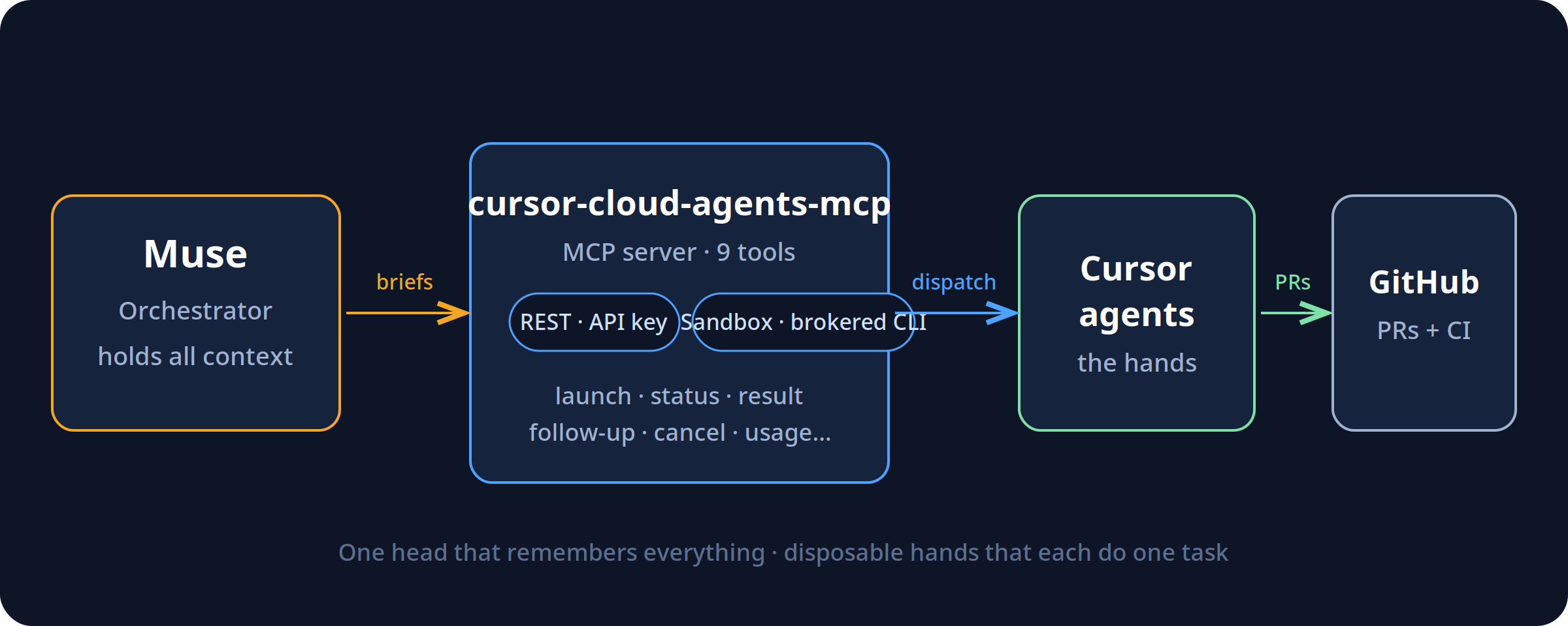
    Everyone’s building the same arrow: human → AI writes code faster. I built the other arrow: AI → AI. My assistant (Muse) holds all my context — my repos, my work orders, my rules. Cursor’s cloud agents hold the hands — they can open PRs, run CI, touch repos. The bridge between them is an MCP server I open-sourced: cursor-cloud-agents-mcp.

    The interesting part isn’t the tools. It’s the shape: one orchestrator that holds all the context, and disposable agents that each know one task. The orchestrator doesn’t write the code — it briefs, checks, and merges. The agents don’t set direction — they execute the brief. That separation is the whole trick.

    Muse-to-Cursor architecture diagram

    Two transports, one repo

    I almost built two projects. Then I realized the only real difference between audiences is where the credential lives. So it’s one repo, two transports:

    • REST — your Cursor API key, direct to api.cursor.com. For general users.
    • Sandbox — for assistants running inside sandboxed environments (like Muse/Meta’s), where there is no API key to hand out. It shells out to a brokered cursor-agent CLI on PATH instead.

    Same nine tools either way: launch, status, result, follow-up, cancel, list, models, whoami, usage.

    The lessons are in the timeouts

    The v1 API splits agents and runs, and launches can take minutes — sometimes timing out after succeeding. So the bridge mints the agent ID client-side before the call: a retry after a timeout can never create a duplicate. A timeout is reported as unknown, never as failure, then reconciled. Run status is the source of truth, because agent “ACTIVE” doesn’t mean “still working.” These are the details that separate a demo from something you can actually operate.

    It earned its keep on day one

    The first thing I pointed it at was its own repo: add CI to cursor-cloud-agents-mcp. The agent opened a PR with a GitHub Actions workflow. The first CI run failed — and caught a real bug: the package’s floating dependency had resolved to MCP 2.x, which renamed FastMCP out from under the import. The repo was shipping broken against current dependencies and nobody knew. Pin, re-run, green, merge. I didn’t touch a terminal.

    I didn’t trust my own first draft

    Before any of that, four AI models reviewed the spec against Cursor’s live docs — and independently caught the same flaw: my original design was shaped around the retired v0 API. Then two more reviewed the actual code and found real bugs: a broken idempotency path, a transport auto-detect that would have grabbed the wrong binary, a polling loop that blocked the server. All fixed before it shipped. The irony I like: the final review round ran through the bridge itself. The launcher timed out on all four agents — and the bridge’s own timeout-reconciliation showed they were all actually running.

    Where this goes

    v1.1 brings MCP 2.x support. Around it, I’m building the rest of the pattern: work orders as GitHub issues, a daily SLA check, a weekly digest — the scaffolding that turns “AI that can open PRs” into something closer to staff. Most people use agents as a faster keyboard. I’m interested in what happens when they’re the hands and something with memory is the head.

    MIT licensed. Issues and PRs welcome — help make it better.

    github.com/tygart-media/cursor-cloud-agents-mcp

  • Storm Updates: Kansas–Oklahoma Watch 667, Ohio Valley Flood Pulse — Saturday, September 12, 2026

    This is a live Saturday afternoon snapshot of local storm-type events across the United States as of Saturday, September 12, 2026. The organized pulse is on the south-central Plains. The Storm Prediction Center holds a Slight Risk of severe thunderstorms across parts of the south-central Plains into the Ozarks, and Severe Thunderstorm Watch 667 is in effect from 3:45 p.m. until 10:00 p.m. CDT for portions of southwest Kansas, Oklahoma, and the Texas Panhandle. Farther east, the Weather Prediction Center keeps a Slight Risk of excessive rainfall over the Ohio Valley and Mid-Atlantic. Tropical Storm Norbert is over the open eastern Pacific and is not a U.S. land threat.

    These are county- and ZIP-scale thunderstorms, not a mainland hurricane landfall. Restoration exposure this afternoon and evening is wind-driven roof and siding work, isolated large hail, trees on service drops, and interior water where cells train over already-wet ground in the Ohio Valley and Mid-Atlantic. Conditions change fast. Verify with the National Weather Service for the specific county or ZIP before you roll.

    What is live this afternoon

    Watch 667 covers southwest Kansas, Oklahoma, and the Texas Panhandle through 10:00 p.m. CDT. Primary threat language from SPC: scattered damaging winds and isolated significant gusts to 80 mph, plus isolated very large hail to 2 inches. Tornado probability in the watch is low. The 2000 UTC Day 1 outlook, issued 3:00 p.m. CDT Saturday, expanded the Slight Risk southwest across parts of western Oklahoma after satellite showed agitated cumulus and isolated initiation along a remnant outflow. Temperatures of 102–104°F south of the wind shift support severe-caliber downdrafts if clusters organize.

    Mesoscale Discussion 2286, issued 2:52 p.m. CDT, flagged southern Kansas into northwest Oklahoma as watch-likely before the watch went up. Most probable peak gusts in that discussion were 65–80 mph; most probable peak hail 1.50–2.50 inches. MD 2287 followed on a severe-potential, watch-possible track as storms tried to fill in.

    WPC’s Day 1 Excessive Rainfall Outlook, valid 12 UTC Saturday through 12 UTC Sunday, keeps a Slight Risk over the Ohio Valley and Mid-Atlantic. That language is flood first, wind second: 2.0–2.25 inch precipitable water along I-95 from Richmond toward Philadelphia, with a higher-end Slight pocket in the upper Ohio Valley where flash-flood guidance is under 2 inches in northern West Virginia and western Pennsylvania. Central Plains stay Marginal for excessive rain. Florida remains in a localized urban-flood environment on 2.0–2.25 inch precipitable water.

    The official SPC Local Storm Report list for the 12 UTC Saturday through 12 UTC Sunday window was still empty as of mid-afternoon, which is expected this early in the convective day. SPC’s same-day report-trend plot on the homepage was already counting preliminary tornado, wind, and hail ticks as storms started to fire. Treat those as unofficial until they land on the LSR page.

    Hotspot 1 — Southwest Kansas, Oklahoma, Texas Panhandle

    This is the live watch. Storms are expected to increase and intensify near an outflow boundary across Oklahoma and near a front across Kansas and the eastern Texas and Oklahoma Panhandles. SPC notes a narrow corridor of 2,000–3,500 J/kg MLCAPE, 30–40 kt of deep-layer shear, and steep mid-level lapse rates that support isolated 2-inch hail before storms cluster. Higher-based convection in the hot mixed layer favors wind over tornadoes.

    Cities and counties to watch: Wichita, Hutchinson, and Emporia in Kansas; Enid, Ponca City, and the Oklahoma City metro fringe; Alva to Chandler along the watch axis; Amarillo and the eastern Texas Panhandle. Neighboring offices: Dodge City, Wichita, Norman, Tulsa, Amarillo.

    Restoration read: wind and hail first. Stage tarps, generators, and glass/roof crews before dark. A 75–80 mph gust on a well-mixed 104°F afternoon is a tree-and-roof ticket, not a regional catastrophe. Photograph roofs in remaining daylight only if it is safe.

    Hotspot 2 — Ohio Valley and Mid-Atlantic flood pulse

    This is the water desk, not the watch desk. WPC holds a Slight Risk of excessive rainfall from the upper Ohio Valley through the Mid-Atlantic. HREF signals in the morning discussion showed moderate-to-high chances of 3-hour and 6-hour flash-flood guidance exceedance in the upper Ohio Valley, and 20–40 percent chances of 3-hour totals over 2 inches from the Richmond area late Saturday into the Delaware Valley and southern New Jersey Saturday night. The Slight Risk was extended north through eastern Pennsylvania, northern New Jersey, and into the New York City metro and lower Long Island for late Saturday night into Sunday.

    SPC keeps a Marginal Risk of isolated damaging wind with loosely organized clusters in the upper Ohio Valley this afternoon. That is secondary to the flood overlay.

    Cities and counties to watch: Pittsburgh and western Pennsylvania; northern West Virginia; Columbus–Dayton corridor on the wind-marginal fringe; Richmond, Baltimore, Philadelphia, and the I-95 urban core Saturday night.

    Restoration read: extraction and drying if cells train. Urban streets, underpasses, and small streams fail first. Do not treat this as the same story as Watch 667. Different hazard, different crew mix.

    Hotspot 3 — North Georgia leftover water and Plains scatter

    National Weather Service Peachtree City issued multiple Flash Flood Warnings this morning for Cobb, DeKalb, Douglas, Fulton, Carroll, and Paulding counties, including Atlanta, Marietta, Sandy Springs, Douglasville, and Villa Rica. Radar-indicated totals of 1–4 inches were already on the ground in those products, with additional 1–3 inches possible in the warned windows. Some of those warnings expired by mid-afternoon; the water is still in the street and in the buildings. That is already a ticket, not a new watch.

    Elsewhere, isolated strong-to-severe cells remain possible on the edges of the Slight Risk into the Ozarks and on the hot High Plains. Florida stays a local urban-flood and lightning desk on deep tropical moisture. A Flash Flood Watch remains up over the Paradise and Hagen burn scar in northeast Oregon and southeast Washington from Saturday afternoon through Sunday evening — debris-flow country, not a CAT event.

    Just hit

    Friday’s official LSR window (12 UTC September 11 through 12 UTC September 12) is the last closed book. Preliminary reports included a tornado touchdown 7 miles northeast of Artichoke, Minnesota, plus golf-ball hail near Artichoke and Alberta in Stevens County, Minnesota. Wind and hail also hit Tarrant County, Texas (Arlington–Mansfield trees, poles, and up to 1.75-inch hail), Bexar County, Texas (golf-ball hail near Converse and Kirby), and a long tree-down swath through South Carolina, Virginia, and North Carolina. Those are already claims. Today’s new work, if it verifies after 12 UTC Saturday, is Watch 667 wind and hail plus Ohio Valley–Mid-Atlantic water.

    Pulse table

    RegionMain threatsSPC / NWS levelStatus this afternoon
    SW Kansas / Oklahoma / TX PanhandleDamaging wind to 80 mph, isolated 2-inch hailSlight + Watch 667 to 10 p.m. CDTLive watch
    Ohio Valley / Mid-AtlanticFlash flood, training heavy rain, isolated windWPC Slight excessive rainfall; SPC Marginal windTonight into Sunday morning
    North Georgia metroUrban flash flood leftover from morning warningsFFW earlier todayAftermath / still in street
    Ozarks / central Plains fringeIsolated hail and windSPC MarginalScattered
    NE Oregon / SE Washington burn scarFlash flood / debris flowFlash Flood Watch through Sunday eveningLocal hydrologic
    Atlantic / Gulf vs. U.S. mainlandNo landfalling tropical cycloneQuiet on the mainland coastQuiet (Norbert open EPAC)

    What this means for restoration teams

    Wind at 65–80 mph is roof, siding, gutter, and tree-on-structure work. Isolated 2-inch hail is broken glass and pitted panels in a narrow swath, not a statewide event. Heavy rain on the Ohio Valley–Mid-Atlantic Slight Risk is wet drywall and a 24–48 hour mold clock. Atlanta-metro water from this morning is already inside some buildings.

    For teams in or near Watch 667: stage before 5 p.m. CDT, not after the first warning. Property owners should photograph damage in daylight if it is safe, call the carrier, and start extraction the same night if water is inside. Do not send the same crew to Oklahoma wind and Pittsburgh water without checking which county actually has a warning now.

    What this is not

    This is not a regional derecho and not a U.S. mainland hurricane landfall. Tropical Storm Norbert is expected to dissipate east-southeast of Hawaii by midweek and is not a CONUS or Hawaii landfall problem on this desk. The work tonight, if it comes, will be scattered: a wind or hail swath through a Kansas or Oklahoma county, a flooded intersection where Ohio Valley or Mid-Atlantic cells train, leftover urban water in metro Atlanta. That is the local-storm pattern this desk should staff.

    Looking ahead

    Sunday, SPC Day 2 is a Marginal Risk of strong storms with small to marginally severe hail and locally damaging wind from the Ohio Valley to the Northeast. Coverage is uncertain. Monday, Day 3 adds a small Slight Risk across eastern Nebraska into western Iowa. Watch the next Storm Tracker update rather than assuming Watch 667 is the last line of the weekend.

    Sources and how to verify

    Primary sources, all date-stamped Saturday, September 12, 2026: NOAA Storm Prediction Center 2000 UTC Day 1 Convective Outlook; Severe Thunderstorm Watch 667; Mesoscale Discussions 2286 and 2287; SPC today and September 11 Local Storm Reports; Weather Prediction Center Day 1 Excessive Rainfall Outlook issued 3:39 a.m. EDT; National Weather Service warning text including Peachtree City flash-flood products; National Hurricane Center public advisory on Tropical Storm Norbert (open eastern Pacific, no U.S. land threat).

    Check weather.gov for the county warning, spc.noaa.gov for the outlook, watch, and LSRs, and WPC excessive rainfall for the flood overlay. Morning desk for this calendar day: Saturday morning Storm Updates. Related desk: Friday afternoon Storm Updates.

    Informational only — not an official weather warning. Follow local authorities and the National Weather Service. Turn around, don’t drown.

  • Storm Updates: Kansas–Oklahoma Slight Risk, Ohio Valley–Mid-Atlantic Flood Pulse — Saturday, September 12, 2026 (Morning)

    This is a live Saturday morning snapshot of local storm-type events across the United States as of the early hours of Saturday, September 12, 2026. Overnight into this morning the organized severe pulse that ran eastern South Dakota into Minnesota has expired. Severe Thunderstorm Watch 666 is down. No convective watches are valid as of mid-morning UTC. The Storm Prediction Center 1300 UTC Day 1 outlook has upgraded the afternoon and evening corridor to a Slight Risk of severe thunderstorms across parts of the central and southern Plains into the Ozarks. The Weather Prediction Center Day 1 Excessive Rainfall Outlook holds a Slight Risk for portions of the Ohio Valley and Mid-Atlantic.

    These are county- and ZIP-scale thunderstorms, not a mainland hurricane landfall. Restoration exposure today is large hail and damaging wind on the Plains, plus interior water where Ohio Valley and Mid-Atlantic cells train. Conditions change fast. Verify with the National Weather Service for the specific county or ZIP before you roll.

    What expired overnight vs what is live this morning

    Watch 666 covered southwestern into north-central Minnesota and eastern South Dakota from 6:40 p.m. to 10:00 p.m. CDT Friday. Primary language was scattered large hail, isolated very large hail to two inches, damaging gusts to 70 mph, and a tornado or two if a supercell held together early in the watch. That watch is expired. SPC current watches page as of 12:03 UTC Saturday: no watches valid. Last issued watch remains 666.

    What is live this morning is the outlook, not a watch. The 0748 AM CDT Saturday Day 1 convective outlook is valid 1300 UTC Saturday through 1200 UTC Sunday. Headline: there is a Slight Risk of severe thunderstorms across parts of the central and southern Plains. Summary language: isolated to scattered severe thunderstorms capable of large to very large hail and severe or damaging winds may occur across parts of the central and southern Plains into the Ozarks this afternoon and evening. A separate Marginal Risk corridor remains over the upper Ohio Valley for isolated damaging gusts this afternoon.

    WPC’s current Day 1 excessive-rainfall outlook, issued 339 AM EDT Saturday and valid 12Z Saturday to 12Z Sunday, keeps a Slight Risk of rainfall exceeding flash-flood guidance for portions of the Ohio Valley and Mid-Atlantic. Precipitable water of 2.0 to 2.25 inches is forecast to stream north along the I-95 corridor from Richmond and Washington toward Baltimore and Philadelphia by Saturday evening, then into the New York metro and lower Long Island late Saturday night. That late-night northern end of the slight risk is expected to linger into Sunday (Day 2).

    Hotspot 1 — Southern Kansas, northern Oklahoma, eastern Oklahoma and Texas Panhandles into the Ozarks

    This is today’s severe ticket. Elevated storms persisted overnight into early morning across southern Nebraska into eastern Kansas and western Missouri on a modest low-level jet. SPC expects that activity to weaken through the remainder of the morning, with some guidance still showing additional development along outflow across southern Kansas and northern Oklahoma. A fairly strong cold front is draped from eastern Colorado into Kansas and northwest Missouri. That boundary is the afternoon focus.

    Along and south of the front, a narrow zone of moderate to strong instability (MLCAPE 2000–3500 J/kg) is forecast this afternoon from the eastern Oklahoma and Texas Panhandles into southern Kansas and northern Oklahoma. Deep-layer shear of about 30–40 kt is enough for organized updrafts. Isolated robust development along the front is favored around 21–23Z once convective temperatures are reached. Sustained supercells would pose a threat for large to very large hail, including isolated two-inch-plus stones. Higher-based convection from the eastern Panhandles into southwest and south-central Kansas and northern Oklahoma favors scattered severe downdrafts. Some gusts could exceed 75 mph. Clustering later this afternoon and evening remains uncertain, but isolated damaging wind may persist into much of Oklahoma and the Ozarks if upstream storms in Kansas and western Missouri stay organized.

    Cities and counties to watch: Wichita, Hutchinson, Emporia, Liberal, and Derby in the Slight Risk core; Oklahoma City, Tulsa, and Kansas City sit in the surrounding Marginal Risk. Restoration read: hail first in the Slight Risk, then wind. Stage tarps and roof kits before mid-afternoon local. If a cell trains on the same ZIP, treat it as a water job by morning.

    Hotspot 2 — Ohio Valley through the Mid-Atlantic I-95 corridor

    This is today’s flood ticket, not the hail ticket. SPC keeps only a Marginal Risk of isolated damaging wind across parts of the upper Ohio Valley this afternoon in a narrow corridor of filtered heating between denser clouds over Ohio and a stationary boundary to the east. Mid-level lapse rates stay poor. The bigger operational signal is WPC. HREF signals include moderate-to-high chances of three- and six-hour flash-flood-guidance exceedance in the upper Ohio Valley, and a 20–40 percent chance of three-hour QPF over two inches from the Richmond area late Saturday afternoon, then from northeast Maryland into the Delaware Valley and southern New Jersey Saturday night. The Slight Risk was extended north through eastern Pennsylvania, northern New Jersey, and into the New York metro and lower Long Island, with that northern end weighted late Saturday night into Sunday.

    Cities and counties to watch: Pittsburgh and western Pennsylvania, northern West Virginia, the upper Ohio Valley; Richmond, Washington, Baltimore, Philadelphia, northern New Jersey, New York City, and lower Long Island on the late-day and overnight rain axis. Restoration read: urban street flooding, low crossings, and wet drywall where cells train. The 24–48 hour mold clock starts when water is inside, not when the outlook expires.

    Hotspot 3 — Just-hit Upper Midwest and leftover Arizona water

    Friday evening’s Slight Risk over far eastern South Dakota into Minnesota verified locally. Preliminary Storm Prediction Center local storm reports for the 1200 UTC Friday to 1159 UTC Saturday window include a tornado touchdown reported seven miles northeast of Artichoke in Stevens County, Minnesota, around 0051 UTC, plus downed power poles eight miles south of Alberta on County Highway 9. Golf-ball hail (1.75 inches) was reported east and south of Artichoke and south of Alberta. Half-dollar hail fell near Dumont, Herman, Norcross, and Toronto, South Dakota. Wind damage and trees on lines were reported around Chokio, Embarrass and Britt in St. Louis County, Whipholt and Longville in Cass County, and Blue Grass in Wadena County, with one report noting possible tornado damage and large trees blocking County Road 23.

    Separate Friday hail and wind clusters hit Tarrant County, Texas (Arlington and Mansfield, golf-ball hail and trees and poles down), Bexar County, Texas after 0310 UTC (golf-ball hail near Converse), and a long tree-down corridor through South Carolina, North Carolina, and Virginia. Arizona flash-flood warnings fired Friday evening over Gila, Coconino, Navajo, Cochise, and Graham Counties, including fire-scar drainages. Those Arizona warnings were evening products; treat them as just-hit water, not today’s new Slight Risk.

    Just hit

    Minnesota and eastern South Dakota are yesterday’s tickets: hail, trees, poles, and at least one reported tornado touchdown that still needs a damage survey, not a new watch. North Texas and San Antonio-area hail are Friday afternoon and overnight work already on the books. The Carolinas and southern Virginia tree-down scatter is the same. Today’s new work, if it verifies, is the Kansas–Oklahoma hail and wind corridor plus localized flash flooding from the Ohio Valley onto the Mid-Atlantic I-95 axis tonight.

    Pulse table

    RegionMain threatsSPC / NWS / WPC levelStatus this morning
    Southern KS / northern OK / Panhandles / OzarksLarge to very large hail, damaging wind, isolated 75+ mph gustsSPC Slight (core) + Marginal surroundOutlook live; no watch yet
    Upper Ohio ValleyIsolated damaging wind; heavy rain / flash floodSPC Marginal + WPC Slight EROAfternoon increase
    Mid-Atlantic I-95 (RIC–DC–BAL–PHL–NYC)Training heavy rain, urban flash floodWPC Slight EROLate afternoon through Saturday night
    Eastern SD / west-central and northern MNHail, trees, poles, reported tornadoWatch 666 expired 10 p.m. CDT FriAftermath / just-hit
    North Texas / San Antonio metroFriday hail and windLocal LSRsAftermath
    Southeast AZ fire scars / washesFlash flood from Friday cellsExpired FFWsAftermath
    Atlantic / Gulf vs. U.S. mainlandNo landfalling tropical cycloneNHC: formation not expected next 7 days in AtlanticQuiet on the mainland coast

    What this means for restoration teams

    Two-inch hail is roof and auto glass work in the Slight Risk counties. Gusts of 60–75 mph are siding, gutter, and tree-on-structure work. A reported tornado near Artichoke, Minnesota, is a narrow swath — staff it as a local damage survey, not a regional event. Ohio Valley and Mid-Atlantic heavy rain is wet drywall and a same-night extraction clock if water is inside. Do not send the same crew to Wichita hail and Pittsburgh flooding without checking which county actually has a warning now.

    For teams in or near the Kansas–Oklahoma Slight Risk: stage before mid-afternoon local, not after the first warning. Property owners should photograph damage in daylight if it is safe, call the carrier, and start extraction the same night if water is inside.

    What this is not

    This is not a regional derecho and not a U.S. mainland hurricane landfall. National Hurricane Center Atlantic outlook at 800 AM EDT Saturday: tropical cyclone formation is not expected during the next seven days. Eastern Pacific Tropical Storm Norbert is well west-southwest of the southern tip of Baja California and is not a U.S. land threat. The work today, if it comes, will be scattered: a hail swath through a Kansas or Oklahoma county, a wind-thrown tree in the upper Ohio Valley, a flooded underpass where Mid-Atlantic cells train. That is the local-storm pattern this desk should staff.

    Looking ahead

    SPC Day 2 is a Marginal Risk Sunday afternoon and evening from western New England through the upper Ohio Valley for small to marginally severe hail and locally damaging gusts. Day 3 is also Marginal. Fire-weather outlooks are Elevated today and Sunday. The next Day 1 convective outlook is scheduled by 1630 UTC. Watch the afternoon Storm Tracker update rather than assuming this morning’s Slight Risk is the last line of the weekend.

    Sources and how to verify

    Primary sources: NOAA Storm Prediction Center Sep 12, 2026 1300 UTC Day 1 Convective Outlook (issued 0748 AM CDT); SPC current watches page (no watches valid; most recently issued Watch 666); SPC preliminary local storm reports for 20260911 1200 UTC–20260912 1159 UTC; Weather Prediction Center Day 1 Excessive Rainfall Outlook issued 339 AM EDT Sat Sep 12, 2026; National Hurricane Center Atlantic Tropical Weather Outlook 800 AM EDT Sat Sep 12, 2026; National Weather Service watch/warning text feed.

    Check weather.gov for the county warning, spc.noaa.gov for the outlook, watch, and LSRs, and WPC excessive rainfall for the flood overlay. Prior desk: Friday, September 11 storm updates (afternoon).

    Informational only — not an official weather warning. Follow local authorities and the National Weather Service. Turn around, don’t drown.

  • Bring Your Own Fleet: The Interview Is About to Change

    Bring Your Own Fleet: The Interview Is About to Change

    Companies already lived through bring-your-own-device. The next one is bigger: bring your own fleet. When you hire someone now, you are not just hiring the person. You are hiring their output capacity — and output capacity includes their AI stack.

    Listen to this essay. Audio version (MP3)

    Two candidates with identical skills and different agent setups are not the same hire. Not close. The resume cannot express any of this. So the interview has to change.

    Architecture diagram of a Grok and Cursor fleet of bots for distributed AI task execution
    A personal fleet and a company bot only talk after the walls are drawn.

    Bring your own fleet. A personal set of AI agents — seats, tools, workflows, integrations, and data walls — that a candidate already runs. In a fleet interview, that stack does a capability handshake with the company’s operations bot, then both sides run a small piece of real work before an offer letter exists.

    What is bring your own fleet?

    Bring your own fleet is the hiring version of bring-your-own-device. The candidate does not show up as a lone operator with a laptop. They show up with the agents that already produce their work: research seats, writing seats, ops seats, and the filters between them.

    I have been building mine this way for months. One seat that knows who I am. Separate seats that know what I do. A filter between them. That is not a product pitch. It is the only setup I would let near a company bot. The shop-floor version of the same idea already lives on this site: Cursor checking in on Grok Desktop mid-job is a fleet, not a chat window.

    Why can’t a resume show an AI stack?

    A resume can list tools. It cannot prove throughput. It cannot show which seats talk to which systems, where the walls sit, or what happens when a task is live instead of described. “Uses ChatGPT” and “runs a governed agent fleet” look the same on paper. They are not the same on a desk.

    That is why the old screen fails first. Degree filters, keyword screens, and whiteboard puzzles all ask the candidate to narrate capacity. Narration is cheap. A fleet that can sit down with an operations bot and do a slice of the actual job is not.

    How does an AI fleet interview work?

    The human intro still happens. Then the agents talk. Your personal AI sits down — figuratively — with the company’s operations bot and they do a capability handshake.

    • What seats do you run?
    • What tools, integrations, workflows, and data assets?
    • What throughput can you demonstrate on a bounded task?
    • Where are the boundaries — what can each side touch, and what stays behind a clean wall?

    Then the part that kills the whiteboard interview: instead of a coding puzzle, the two fleets run a small piece of real work together. The trial task is the interview. You do not describe what you could do. The work gets done, live, before the offer letter exists.

    Old interviewFleet interview
    Resume plus degree screenWorking system as the portfolio
    Whiteboard or take-home puzzleBounded live trial on real work
    Claims about toolsCapability handshake: seats, walls, throughput
    Trust the storyWatch the output, then talk terms

    What is an agent clean room?

    An agent clean room is a verified wall between the personal seat and the work seats. The personal agent translates. It does not cross over. It must never leak a private life into an employer system. Without that wall, no sane person lets their agent near a company bot.

    This is AI hygiene, not a slogan. The same discipline we write about when agents share a WordPress lock or a night shift: one owner, one wall, one recovery path. See Four Agents, One WordPress Lock and the operator note in Wire and Fire Guys. A handshake without a clean room is just another attack surface with a friendly name.

    Why does the fleet beat the diploma?

    I do not have a degree. In the old world, that is a filter that screens me out before a human ever reads my name. In the handshake world, it is irrelevant — because “here is my working system, watch it do the job” beats “here is my diploma, trust that I could learn the job” every time. The fleet is the portfolio.

    That is not an argument against school. It is an argument against using school as a proxy for output you can now watch. If the trial task is real work, the credential becomes a footnote.

    What breaks first if companies try this?

    The objections land fast, and they are honest.

    • Ownership. Who owns the workflows when a personal fleet plugs into an employer? You built it on your own time. It now runs their playbooks. That is the “who owns your work laptop” fight, upgraded. Nobody has a settled answer.
    • Security. Their bot talking to your agent is an attack surface in both directions. The clean room has to be verifiable, not promised.
    • Offboarding. When you leave, what stays running and what takes the employer’s data with it? Offboarding for agents does not exist yet.
    • Trust. How does their bot trust your capability claims? Trial tasks help. Claims are cheap. Demonstrated throughput is not.

    You do not wait for a protocol to be ratified before you build the wall. The pieces are already here: the seats, the clean room, the trial task. Somebody is going to ship the first version of this. It might as well be someone who already runs their life this way.

    What we would not claim

    • That a standard for agent handshakes already exists. It does not.
    • That every role should interview this way tomorrow. High-stakes, high-output knowledge work is the first fit.
    • That a personal fleet is automatically safe to plug into a company. Without a clean room, it is not.
    • That this replaces human judgment. The human intro still happens. The fleet only replaces the part of the interview that was already theater.

    FAQ

    What is a capability handshake in hiring?

    A capability handshake is a structured exchange between a candidate’s personal agents and an employer’s operations bot. Both sides declare seats, tools, integrations, data walls, and what they can touch. The point is not a demo script. It is a map of capacity and boundaries before any live work starts.

    Is bring your own fleet the same as bring your own device?

    No. BYOD was hardware and a policy packet. Bring your own fleet is software labor: agents that already produce work. The risk is not a lost laptop. The risk is a personal agent leaking private context into an employer system, or an employer workflow walking out inside a personal seat.

    Do you need a degree if the fleet is the portfolio?

    Not for the screen that used to happen before a human read the name. A degree can still signal training. It cannot substitute for a working system that completes a bounded trial task in front of both sides.

    How do you keep a personal AI out of company data?

    Separate seats. One identity seat that never joins the employer handshake. Work seats that only see what the clean room allows. A filter that translates tasks instead of forwarding raw personal context. If you cannot show that wall, you should not plug in.

    Sources: Will Tygart, Tygart Media, Tacoma, WA, 11 September 2026. First-person operating note on personal agent seats, clean-room separation, and fleet interviews. Related Tygart pages: Cursor mid-job check-in, four agents, one lock, wire and fire guys, AI operating stack.

  • The 1 MB Limit Ate the Clips. The Twins Got a 301. Home Still Has Zero Guide Links.

    This is not a weekly recap. It is the receipt for three things that actually failed or got patched in the last seven days. The sources are the Tygart Ops cards, not a brainstorm. GitHub org TygartMedia did not move this week. The breaks lived in WordPress, nginx, and a parked hang.

    The clips were not YouTube. They were us.

    We reused a guest appearance onto Restoration Intel. The article went live. The YouTube embed was fine. The inline MP4s were not. First pass through the REST write path, the files came back grainy at roughly 432 pixels, 56 to 138 kb/s. Easy to blame the source kit. It was not the source kit.

    Nginx on the knowledge-cluster box still has client_max_body_size 1m. That is a Pinto leftover. Fat uploads 413. The agent did what agents do when the pipe is too small: it re-encoded until the file fit. That is how you get a square clip that looks like it was filmed through a sock.

    The patch on the post itself was a one-off chunked replace. Live MP4s now SHA-256 match the kit files. 1080 by 1080. 6.57 to 19.02 MB. The article is correct. The box is not. Future fat REST uploads will 413 until someone sets nginx to 32m and PHP upload/post to at least 32M on that VM. We are not standing up a helper plugin to hide the limit.

    If you run self-hosted WordPress and an agent write path, check the body size before you ship media. The 413 does not always surface as a clean error. Sometimes it surfaces as a “successful” upload of a crushed file. That is worse than a hard fail. The hard fail makes you stop. The squash makes you publish junk and argue about cameras.

    Twin slugs are not a content strategy.

    Tygart Media had two leftover Claude URLs sitting next to the live desks. /claude-ai-pricing-2/ and /latest-claude-models/. Both already noindex, both already carrying a canonical. That is the polite way to leave a mess. Search engines still find twins. Agents still cite twins. Operators still edit the wrong one.

    On 8 September the 301/302 lane moved to Pinto. The card closed this week after the live check: /claude-ai-pricing-2/ now 301s to /claude-ai-pricing/, and /latest-claude-models/ 301s to /current-claude-model-version/. WP Admin noindex matches what the connector sees. Done-when was both twins 301, not “we will canonical our way out of it.”

    The standing rule on that card is the useful part. Do not mint a third pricing URL. The citation desks already fight each other when the official numbers move. A third slug is how you get two agents writing two patches to two pages that should have been one page. If the model page needs a new title, change the title. Do not clone the URL and hope Rank Math sorts the family later.

    Redirects are cheap. Duplicate living pages are not. A 301 is a patch. A second slug with a canonical tag is a shrug.

    The home page still does not point at the guide.

    On a restoration site we own the work on, the home body is supposed to send “water or fire damage” to the live guide-2 URL. Pre-check on 11 September at about 8:30 AM PT: home guide-2 hrefs equaled zero. The water hub already had the link. The hubs were 200. H1 count was 1. The older -2 and -3 redirects to guide-2 were holding. Home was the hole.

    The hang got assigned. Then it got parked the same morning, about 11:39 AM PT, behind a session wall. Status on the card reads Done because the hang was parked, not because the link exists. Home still has zero guide-2 hrefs. Resume only on a re-assign. Hurricane and flood 404s stay parked behind it.

    That is the kind of break that does not page anyone. The site is up. The guide is up. The money phrase on the home page just does not go where the rest of the architecture already goes. Crawlers will keep scoring the hub. Humans who land on home will keep missing the desk you already built. Interlink work that stops at the interior pages is half a patch.

    We do not name the client beyond the internal slug. The lesson does not need the name. If the home widget is the last place the live URL should appear, treat a zero-count pre-check as an outage, not as a nice-to-have in the daily hang loop.

    One thing we will not repeat

    We will not treat a successful media write as proof the file is the file. The RI clips “uploaded.” They were the wrong bytes. SHA-256 against the kit is the check. Visual vibe is not the check. “It posted” is not the check.

    Same class of mistake as minting -2 slugs when the first URL is still live. The system accepted the write. The system did not protect the shape of the library. Operators have to put the hash and the 301 in the done-when, or the agent will keep delivering a green card with the wrong object behind it.

    The patch still open

    Nginx on the Restoration Intel box is still 1 MB. That is the open patch. The article is fixed. The next fat REST upload is not. 32m on nginx and 32M on PHP upload/post is the actual close. Until that lands, every media write on that VM is one leftover limit away from another squash.

    Second open, different box: a traffic spike on the knowledge cluster around 1:51 PT. The card says about 2,487 requests per hour and nine wp-login POSTs. The instruction on the card is a read-only log pull and a one-paragraph verdict. No firewall change, no plugin change, no credential change without a named gate. That card is still not started. A spike is not automatically an attack and it is not automatically “leave it.” It is a log plus a verdict. Until the verdict exists, it stays an open patch, not a story.

    GitHub this week added nothing to the picture. Org repos last moved in July and August. No commit lane, no issue lane worth citing. The week’s failures were in the CMS and the reverse proxy, which is where most of this operation actually lives.

    Shipped this week on the public site was other work: citation desks, storm desks, a Canva template read, a Mastheads changelog note. None of that is this post. This post is the three cards that broke or got taped. The clips match the kit now. The twin Claude URLs 301. Home still does not point at the guide. The 1 MB limit is still sitting on the box that will eat the next file.

  • Your Website Doesn’t Need More Traffic. It Needs to Be the Answer.

    Your Website Doesn’t Need More Traffic. It Needs to Be the Answer.

    Most restoration contractors are invisible where it now matters most: inside the AI answers. When a facility manager asks Copilot who to call for a commercial loss, the model does not scroll your homepage. It cites whoever taught it the cleanest sentence.

    Your website does not need more traffic. It needs to be the answer. Zero-click search already took the click. The remaining win is being named inside the answer itself. That is a different game than ranking a page, and most agencies are still scoring the old one.

    Cited answer. A cited answer is the short, checkable sentence an answer engine lifts into Copilot, ChatGPT, Perplexity, Gemini, Bing Copilot, or a Google AI Overview and attributes to a URL. Traffic is optional. The attribution is the asset.

    Why are restoration contractors invisible inside AI answers?

    Commercial buyers no longer start with a ten-blue-link session. They type the job into an assistant: who handles a sprinkler discharge on a mid-rise, what a drying standard actually requires, whether a vendor is after-hours in this metro. The model answers from pages that already look like briefings.

    Most contractor sites still look like brochures. Hero image. Five service tiles. A form. A blog post that restates the service name. There is no 40-to-60-word answer under the question the buyer asked. There is no timetable, no definition, no named protocol. The model has nothing safe to lift, so it lifts a national franchise FAQ, an insurer explainer, or last year’s trade-press roundup.

    That is not a branding problem. It is a retrieval problem. We wrote the longer architecture in Restoration Company SEO: Fix Your AI Search Visibility and in the three-layer SEO / AEO / GEO frame. This note is the field version: one receipt, one buyer question, one scoreboard change.

    What did a 20-page race guide teach us about citations?

    Race weekend in Madrid. We published a small independent visitor guide at racemadrid.com — twenty static pages, Spanish primary, English secondary, no ticket shop. Through 8 September 2026, Bing Webmaster showed 144 clicks and 3,218 AI citations. On 8 September the model quoted the site 55 times for every human click.

    The queries were not “who wins.” They were traveler questions: Sunday end time, cash or card, gate open, hotel to track, can I bring a bag. The pages that earned both clicks and citations were the schedule, the circuit, and the FAQ. That field note is public: We Built a Tiny Site for a New F1 Track. The Clicks Were Small. The Citations Were Not.

    Same playbook we run for restoration companies: be the clearest answer to the question the buyer is actually asking. A facility manager after a loss is in the same posture as a traveler the night before a sold-out race. They do not want your brand story. They want the next true sentence.

    How is that different from SEO?

    SEO still matters. It is the foundation that lets a URL exist, resolve, and get fetched. AEO is how a featured snippet or People Also Ask box can lift a clean block. GEO is how a generative engine decides you are safe enough to speak for. We treat them as concentric layers on one page, not three rewrites. The operator version of that stack is in What Is GEO? and in what GEO delivery looks like inside a real engagement.

    LayerQuestion it answersWhat you ship
    SEOCan the engine find and trust the URL?Title, meta, headings, first-100-word keyword, internals, schema that is true
    AEOCan a snippet lift one block without rewriting you?Question H2, 40–60 word answer, FAQ, definition box
    GEOWill a model cite you when a buyer asks in chat?Checkable facts per paragraph, entity names, dates, sources, bilingual or local variants when the buyer uses them

    If you only measure sessions, you will call a 55-to-1 citation ratio a failure. If you measure whether the model will say your name when a facilities director asks who to call, that ratio is the product.

    What does the restoration version of a cited answer look like?

    It looks like a briefing, not a pitch. The H2 is the question. The next paragraph answers it in plain language, with a number or a standard attached. Then the proof: what you do on site, what you do not do, the metro you actually cover, the clock you keep.

    • Who to call after a commercial sprinkler discharge in this building class, after hours.
    • How long a category of water stays a drying job before it becomes a rebuild conversation.
    • What the carrier packet has to include on day one so the file does not stall.
    • Which document the facility manager should send before the first truck rolls.

    Write those as answers a model can quote without inventing a second sentence. Put the misspellings and the local names on the page on purpose. Madrid taught us that travelers cannot spell a new circuit. Facility staff cannot spell your d/b/a either. Cover the words they type.

    What is a citation worth if nobody clicks?

    On the race guide, a citation is proof of position. It is not a ticket sale. We said that in the field note and it stays true here. A restoration citation is worth more than a travel citation only if you already own the next step: the phone, the after-hours board, the approved-vendor list, the estimator who can take the job tonight.

    If the sentence the model lifts is wrong, the citation is a liability. We locked a Sunday start time off an older F1.com page and the official MADRING time was later. That error is still the most-clicked kind of question in the logs. The next hour of work is not a new URL. It is correcting the fact the model already trusts. Restoration pages have the same failure mode: an outdated response-time claim will travel farther than the correction.

    What we would not claim

    • That 144 Bing clicks is a media business.
    • That citations replace Google. The Madrid export is Bing Webmaster plus Clarity. Google Search Console is a separate pile.
    • That being cited is automatically good. It is good if the fact is right and you have a use for the attention.
    • That this article invents a new discipline. SEO, AEO, and GEO are already named on this site. This is the operator sentence we are willing to put on LinkedIn and stand behind.

    What we would do again

    Show up early on a named question that does not have a settled official FAQ. Write the buyer’s language, not the agency’s. Keep the page short enough to finish. Put the clock in one place and keep it tied to a source you can defend. Do not invent a content brand around a weekend — or around a single storm.

    The models will quote you if the sentence is plain. The humans who still click will click the schedule, the response protocol, the packing list. Everyone else will take the answer and move. Your job is to be the sentence they take.

    FAQ

    What is the difference between AEO and GEO?

    AEO — Answer Engine Optimization — structures a page so a featured snippet, People Also Ask box, or voice result can lift a complete answer. GEO — Generative Engine Optimization — structures the same page so a generative model will cite that URL when a person asks in chat. One page. Two retrieval systems.

    Does zero-click search mean a restoration website is useless?

    No. It means the homepage-as-brochure is the wrong artifact. The useful site is a set of briefings the model can quote and the buyer can still open when they need the packet, the photo standard, or the after-hours number.

    How do you know a page is being cited?

    You measure it on more than one desk. Bing Webmaster now reports AI citations. Clarity shows whether the humans who still arrive actually read. Prompt checks in Copilot, ChatGPT, Perplexity, and Gemini tell you whether the brand is named. We keep the method on AI citation monitoring and on the Bing citation mining thesis.

    Is this only for restoration companies?

    No. Restoration is the vertical where a missed answer has a wet building attached to it. The same pattern holds anywhere a buyer asks an assistant a time-sensitive operational question and needs a named next step.

    Sources: Will Tygart, Tygart Media, Tacoma, WA, 11 September 2026. First-party Bing Webmaster and Microsoft Clarity figures for racemadrid.com through 8 September 2026, as published in the Madrid field note. Related Tygart pages: restoration AI visibility, GEO explainer, GEO delivery.