Tag: Louisiana

  • Storm Updates: Isaias Slight Tornado Risk, Gulf Landfall Tonight — Friday, October 9, 2026 (Morning)

    This is the Friday morning Storm Tracker desk for October 9, 2026. Overnight into this morning the organized severe window moved from a small Iowa hail threat to the northern Gulf Coast. The Storm Prediction Center 1300 UTC Day 1 convective outlook, issued 7:57 a.m. CDT, places a Slight Risk of severe thunderstorms across northern Florida, southeast Alabama, and southwest Georgia. The driver is Hurricane Isaias, still offshore. No convective watches are valid. The Weather Prediction Center holds a Moderate Risk of excessive rainfall over southern Alabama, the Florida Panhandle, and southwest Georgia.

    Isaias has not made U.S. landfall. National Hurricane Center Intermediate Advisory 11A, corrected, at 7:00 a.m. CDT places the center near 27.0N 87.7W, about 245 miles south of Pensacola and about 170 miles south-southeast of the Mouth of the Mississippi River. Maximum sustained winds are near 110 mph, movement north-northeast near 15 mph, minimum pressure 958 mb. Hurricane-force winds extend outward up to 30 miles. Tropical-storm-force winds extend outward up to 185 miles. NHC says Isaias is on the cusp of major-hurricane strength, is likely to become a major hurricane this morning, and is expected to remain a dangerous hurricane at landfall this evening or tonight inside the warning area. Preparations in the storm-surge and hurricane warning areas should be completed within the next few hours.

    These remain county- and ZIP-scale hazards until the core comes ashore. Verify with the National Weather Service for the specific county or ZIP before you roll. Conditions change with the next advisory.

    What is live this morning

    SPC lists no convective watches currently valid. The watch board’s most recent number, Severe Thunderstorm Watch 676, was a west-central Texas watch from the afternoon of September 30 and expired at midnight CDT that night. It is not a live product. The next Day 1 outlook is scheduled by 1630 UTC. Tornado potential is forecast to increase this afternoon and continue tonight, especially across the Florida Panhandle into southeast Alabama and southwest Georgia, as eastern rainbands spread north and low-level winds and storm-relative helicity strengthen. SPC also notes some enhancement to the wind field, including a convective influence, across southern Alabama near the evolving inverted surface trough late this afternoon into tonight.

    The Slight Risk area covers about 25,034 square miles and roughly 1.97 million people. Larger centers named by SPC include Tallahassee, Dothan, Pensacola, Valdosta, and Panama City. The surrounding Marginal Risk covers about 42,289 square miles and roughly 3.98 million people, with larger centers including Jacksonville, Mobile, Savannah, Gainesville, and Albany. NHC tornado language is narrower in time: a tornado risk beginning late this afternoon and continuing tonight in coastal Alabama, the Florida Panhandle, and far southwest Georgia, then continuing Saturday across parts of eastern Alabama, the Florida Panhandle, Georgia, and the Carolinas.

    Tropical warnings are the live watch equivalent this morning. A Storm Surge Warning runs from the Mouth of the Mississippi River to the Suwannee River. A Hurricane Warning runs from Ocean Springs, Mississippi, to the Bay/Gulf County line in Florida. Tropical Storm Warnings cover the Jefferson/Plaquemines Parish line in Louisiana to west of Ocean Springs, and the Florida coast east of the Bay/Gulf County line to the Aucilla River. A Storm Surge Watch continues from the Suwannee River to Yankeetown, Florida. Intermediate Advisory 11A corrected the surge values. If the peak coincides with high tide, water could reach 6 to 9 feet above ground from the Alabama/Florida border to Grayton Beach; 4 to 6 feet from Dauphin Island to the Alabama/Florida border and in Mobile Bay; 4 to 7 feet from Grayton Beach to Indian Pass; 4 to 6 feet from Indian Pass to the Steinhatchee River; 3 to 5 feet from Steinhatchee to the Suwannee and from the Mouth of the Mississippi to Dauphin Island; and 2 to 4 feet from the Suwannee to Yankeetown.

    Hurricane conditions are expected in the hurricane warning tonight into early Saturday, with tropical storm conditions beginning later today. Tropical storm conditions are expected in the warning areas beginning in the next few hours from the 7:00 a.m. CDT advisory.

    Overnight into this morning

    The convective day that closed at 1159 UTC this morning did not produce a tornado or wind report on the SPC filtered log. It did produce hail. The overnight reports sit on yesterday’s Iowa Marginal Risk, not on the Gulf. SPC lists 1.00-inch hail 2 miles south of Sioux Center, Iowa, at 0226 UTC; 1.50-inch hail at Panora in Guthrie County at 0237 UTC; 1.00-inch hail at Orange City; 1.00-inch hail at Redfield in Dallas County at 0305 UTC; 1.50-inch hail at Ireton; 1.25-inch hail at Wall Lake in Sac County at 0320 UTC; 1.50-inch hail at Cherokee at 0337 UTC; 1.25-inch hail west of Norwalk in Warren County at 0401 UTC; 1.50-inch hail at Alcester in Union County, South Dakota, at 0532 UTC; and a measured 1.00-inch hail on the 200 block of Lloyd Street in Lake City, Calhoun County, at 0552 UTC. Those are preliminary local storm reports. They are the just-hit record from last night. They are not a continuing Iowa watch.

    Thursday evening flash-flood products on the national summary were short-fused and have expired for this desk. Jacksonville issued a flash flood warning for east-central Nassau County, including Fernandina Beach, Yulee, and Amelia City, at 5:19 p.m. EDT Thursday, with 2 to 4 inches already down and another 1 to 2 inches possible, until 7:00 p.m. EDT. Honolulu issued a flash flood warning for Oahu at 10:21 a.m. HST Thursday after water over Kamehameha Highway on the North Shore, until 1:15 p.m. HST. Neither is a live warning this morning. Storm-surge warnings on the northern Gulf Coast from Thursday evening remain the standing coastal product and match the NHC warning.

    Water pulse

    WPC’s Day 1 Excessive Rainfall Outlook, updated 0825 UTC and discussed at 4:28 a.m. EDT, keeps a Moderate Risk of excessive rainfall in southern Alabama, the Florida Panhandle, and southwest Georgia, valid 12 UTC Friday through 12 UTC Saturday. WPC says numerous instances of flash flooding are likely, some significant, and that the outlook is consistent with the previous forecast. Heavier rain rates ramp up closer to landfall and after, as the strongest instability in the southeast quadrant reaches the coast. The flash-flood threat should increase markedly from late Friday afternoon into Friday night.

    Two corridors matter. Inner-core and eyewall rain is the coastal problem in southern Alabama and the western Florida Panhandle, highest closest to the coast. Farther east, a training band along the instability gradient can sit about 200 miles east of the landfall point. WPC says that band has better access to instability and deep tropical moisture, can produce double-digit totals of 10 inches or more if it trains, and may hold the event maximum. The Moderate Risk was nudged slightly east, including the chance the band sets up east of Tallahassee at times, and extended into southwest Georgia at least 100 miles inland. Inland along the track into eastern Mississippi and central Alabama stays at Slight for now, because shear is increasing and the inland flash-flood reach depends on whether the core holds together. NHC rainfall through the weekend is 4 to 8 inches across southern Alabama, the Florida Panhandle and Big Bend, and southwest Georgia, with localized totals up to 15 inches in banding across the Panhandle and Big Bend. Much of the rest of the Southeast is forecast at 2 to 5 inches, with localized amounts up to 10 inches possible in the southern Appalachians and coastal Carolinas. River flooding is also expected, some of it significant.

    Pulse table

    RegionMain threatsSPC / NWS levelStatus this morning
    Northern Gulf Coast (MS / AL / FL Panhandle)Hurricane wind, storm surge, heavy rain tonightHurricane Warning; Storm Surge Warning; NHC Advisory 11AWarnings up; center still offshore
    FL Panhandle / SE Alabama / SW GeorgiaTornado in outer bands; damaging wind near the troughSPC Slight; tornado risk late today into tonightLive outlook, no convective watch
    East of landfall, Big Bend into SW GeorgiaTraining rain, flash flood, local 10–15 inchesWPC Moderate excessive rainfallRamp late afternoon into tonight
    Eastern Mississippi / central AlabamaInland rain along the track if the core holdsWPC SlightTrack-dependent
    Iowa / southeast South DakotaHail to 1.50 inches overnightYesterday’s Marginal; reports onlyExpired overnight pulse
    Rest of the CONUS severe mapNo general thunderstorm watchNo convective watch validQuiet outside the Gulf corridor

    Restoration read

    This morning is still a prep window, and it is closing. The first exposure on the northern Gulf Coast is life-safety surge and wind, not a ticket count. Hurricane-force wind is a small radius, about 30 miles from the center, so structural wind damage will be concentrated near the landfall point inside the hurricane warning from Ocean Springs to the Bay/Gulf County line. Tropical-storm-force wind reaches much farther, out to about 185 miles, and that is the power, tree, and soft-roof radius that will show up well away from the eye. Surge of 6 to 9 feet above ground, if it verifies from the Alabama/Florida border to Grayton Beach, is the coastal floor and marina problem. It is not a uniform flood across the whole warning.

    Water is the broader restoration pulse, and it is offset from the center. WPC is explicit that the training band east of landfall, on the order of 200 miles east, can hold the rainfall maximum. Crews that staff only the landfall pin will miss the flash-flood ground in the Florida Big Bend, around Tallahassee, and into southwest Georgia. Saturated roads, underpasses, and small creeks are the overnight into Saturday problem. River flooding follows. Iowa hail is a closed overnight note: roof and vehicle checks in Guthrie, Sioux, Sac, Cherokee, Dallas, Warren, and Calhoun counties, and at Alcester, South Dakota, not a new dispatch.

    Do not treat a Slight Risk as a watch. SPC has not issued a tornado watch yet. The tornado window in NHC language opens late this afternoon in coastal Alabama, the Panhandle, and far southwest Georgia. If a watch goes up on the 1630 UTC outlook cycle, that is the afternoon desk’s update, not a fact this morning.

    Looking ahead

    Landfall is forecast tonight or early Saturday inside the hurricane warning. After landfall, gusty winds are expected well inland over the Southeast as the wind field grows in the trough interaction. Saturday’s tornado threat shifts across eastern Alabama, the Florida Panhandle, Georgia, and the Carolinas. Rain of 2 to 5 inches, locally 10, reaches the southern Appalachians and coastal Carolinas through the weekend. The next complete NHC advisory is scheduled for 10:00 a.m. CDT. The next SPC Day 1 outlook is scheduled by 1630 UTC.

    Sources

    Disclaimer

    This is a morning snapshot from official National Weather Service, Storm Prediction Center, Weather Prediction Center, and National Hurricane Center products. It is not a warning, not a watch, and not a substitute for local emergency management. Hurricane, storm-surge, tropical-storm, tornado, and flash-flood products can be issued or canceled between desk cycles. Check weather.gov and hurricanes.gov for the county or ZIP before you travel or stage.
  • Storm Updates: Gulf Isaias Warnings, Florida Marginal — Thursday, October 8, 2026 (Morning)

    This is the Thursday morning Storm Tracker desk for October 8, 2026. Overnight into this morning the organized severe window stayed closed, then the 1300 UTC Day 1 outlook opened two small marginal areas. The live story is not a plains watch. It is Hurricane Isaias, now an 80 mph hurricane in the central Gulf of America, with hurricane and storm surge warnings already up on the northern Gulf Coast for a late Friday or early Saturday landfall.

    The Storm Prediction Center 1300 UTC Day 1 convective outlook, updated 7:46 a.m. CDT and valid 1300 UTC Thursday through 1200 UTC Friday, carries a Marginal Risk across parts of the Florida Peninsula and across parts of the Upper Midwest and middle Missouri Valley. SPC had no convective watches in effect at 13:21 UTC. The most recently issued watch is 676, and it is not valid. Today’s SPC storm-report page, covering 1200 UTC Thursday through 1159 UTC Friday, had received no tornado, hail, or wind reports at the morning scan. The overnight 0100 UTC Day 1 outlook, issued 7:58 p.m. CDT Wednesday, carried no severe thunderstorm areas through daybreak.

    These are county-scale warnings and a named tropical cyclone, not a scattered high-plains hail chase. Restoration exposure through Saturday is surge, wind, and interior water on the central Gulf Coast, plus a localized Florida flood pulse that is already on saturated ground. Conditions change with the next advisory. Verify with the National Weather Service for the specific county or ZIP before you roll.

    What is live this morning

    National Hurricane Center Intermediate Advisory 7A, 7:00 a.m. CDT, places Hurricane Isaias near 23.7N 90.6W, about 175 miles north-northwest of Progreso, Mexico, and about 385 miles south-southwest of the mouth of the Mississippi River. Maximum sustained winds are near 80 mph. Minimum central pressure is 975 mb. Motion is east-northeast at 9 mph. Hurricane-force winds extend outward up to 15 miles from the center. Tropical-storm-force winds extend outward up to 90 miles. Hurricane Hunters were investigating the storm at advisory time.

    A Storm Surge Warning is in effect from the mouth of the Mississippi River to the Steinhatchee River, Florida. A Hurricane Warning runs from Ocean Springs, Mississippi, to the Bay/Gulf County line, Florida. A Tropical Storm Warning covers the Jefferson/Plaquemines Parish line, Louisiana, to west of Ocean Springs, and east of the Bay/Gulf County line to the Aucilla River, Florida. A Storm Surge Watch continues from the Steinhatchee River to Yankeetown, Florida. No watch or warning changes were made on the 7 a.m. intermediate advisory. Preparations along the warning area should be rushed to completion today. Landfall is forecast along the U.S. northern Gulf Coast inside the warning area late Friday or early Saturday. Additional strengthening is expected through early Friday, and Isaias is forecast to remain a dangerous hurricane as it approaches the coast Friday night.

    Peak surge heights above ground, if the peak coincides with high tide: Ocean Springs to Indian Pass, 5 to 7 feet; Mobile Bay, 5 to 7 feet; mouth of the Mississippi River to Ocean Springs, 3 to 5 feet; Indian Pass to the Steinhatchee River, 4 to 6 feet; Steinhatchee River to Yankeetown, 2 to 4 feet; Lake Pontchartrain, 1 to 3 feet. The deepest water is expected along the immediate coast near and east of landfall, with large waves on top of the surge.

    Hotspot 1 — Northern Gulf Coast hurricane warning

    This is the warning, not a watch. Hurricane conditions are expected inside the Hurricane Warning Friday night into early Saturday, with tropical-storm conditions beginning Friday. Cities and counties on the warning corridor include Ocean Springs and the Mississippi coast east of there, coastal Alabama including Mobile Bay, and the Florida Panhandle through Bay County: Panama City, Panama City Beach, Mexico Beach, and Lynn Haven sit inside the local hurricane and storm surge warning language from the Tallahassee office. Tropical-storm conditions are expected farther west into southeast Louisiana and farther east toward the Aucilla River.

    Rainfall from Friday through the weekend is forecast at 3 to 7 inches, with localized totals up to 10 inches, from far southeastern Louisiana to the Florida Panhandle. Amounts of 1 to 3 inches, locally up to 5 inches, are possible across much of the Southeast as far north as the Tennessee Valley and the Carolinas. Flash and urban flooding, and isolated river flooding, are possible. Isolated tornadoes are possible Friday night in coastal Alabama, the Florida Panhandle, and far southwestern Georgia, then Saturday across eastern Alabama, Georgia, and northern Florida.

    Restoration read: surge and wind first, water second. Roof, siding, awning, and porch damage is the Friday-night ticket where hurricane-force gusts verify. Surge flooding is a life-safety event before it is a drying job. Do not stage crews into the warning area once tropical-storm-force winds arrive. The interior water clock starts after the surge recedes and rainfall trains inland Saturday into the Tennessee Valley. Photograph only if it is safe and daylight remains.

    Hotspot 2 — Florida Peninsula marginal tornado and flood

    SPC’s categorical Marginal Risk on the middle Florida Peninsula is a 2 percent tornado probability, not a wind or hail area. Population centers named on the tornado graphic include Tampa, St. Petersburg, Clearwater, Lakeland, and Brandon, about 4.2 million people inside roughly 7,900 square miles. Storms are focusing along a convectively reinforced front from the eastern Gulf across the middle Peninsula. Tampa Bay radar wind profiles sampled weak low-level flow with moderate directional turning and a speed increase above 3 km, netting about 25 to 30 knots of effective shear. SPC notes a low-confidence chance of a near-shore waterspout or a brief tornado inland near the front. That is not a high-confidence severe day. It is a brief-spin risk on an already wet front.

    The Weather Prediction Center Day 1 Excessive Rainfall Outlook, updated 0821 UTC and valid 12 UTC Thursday through 12 UTC Friday, keeps a Marginal Risk over much of the Florida Peninsula. A stalled front is still the driver. North Florida soils are fully saturated after consecutive rain days, so light to moderate rain converts to runoff. Isolated flash flooding is most likely where convection develops over a larger city such as Tampa or Orlando. Broader issues are poor drainage and urban streets, not a regional river flood. No Slight or Moderate excessive-rainfall area is on the Day 1 map.

    Restoration read: Florida today is extraction on saturated ground and a brief tornado survey if one verifies near the front. It is not the Gulf landfall. Keep the Peninsula crew separate from the Panhandle warning.

    Hotspot 3 — Iowa and the middle Missouri Valley tonight

    The second Marginal Risk is elevated hail, not a daytime surface outbreak. SPC places a 5 percent hail probability over about 30,100 square miles and 1.7 million people, including Des Moines, Sioux City, Waterloo, Ames, and West Des Moines. Isolated to widely scattered elevated thunderstorms are expected tonight as warm advection and isentropic ascent increase northeast of a warm front. Moisture is modest. Mid-level moistening on the edge of the Plains elevated mixed layer is enough for a hail threat, not a damaging-wind area. No wind probabilities were drawn on the 1300 UTC outlook.

    Restoration read: this is an overnight hail ticket if it verifies, roof and auto glass, not a watch-box wind event. Do not staff it like a Great Lakes slight risk. Check local warnings after dark before rolling.

    Watches that expired versus what is still live

    No SPC convective watch is live this morning. Wednesday’s afternoon desk already had a closed severe window, and the 0100 UTC update kept that closed through daybreak. The products that are live are tropical, not convective: the hurricane warning, the storm surge warning, the tropical storm warnings, and the storm surge watch listed above. Alaska winter-storm and high-wind warnings are in effect for parts of the Brooks Range, the Bering Strait coast, and the Alaska Range. Those are not the CONUS restoration pulse this desk is tracking.

    Just-hit reports from last night are thin. SPC logged no severe reports on the Thursday page at the morning scan, consistent with the no-severe overnight outlook. The just-hit story is intensification, not damage: Isaias was a 65 mph tropical storm on Wednesday afternoon’s desk and is an 80 mph hurricane at 7 a.m. CDT, pressure down to 975 mb. No U.S. landfall has occurred. Swells reach the Yucatan later today and the Gulf Coast on Friday.

    Pulse table

    RegionMain threatsSPC / NHC / WPC levelStatus this morning
    Ocean Springs to Bay/Gulf County lineHurricane wind, surge 5–7 ft, rain 3–7 inHurricane Warning; Storm Surge WarningLive; landfall late Friday or early Saturday
    SE Louisiana to west of Ocean Springs; east of Bay/Gulf line to Aucilla RiverTropical-storm wind, surge 3–5 ft west, 4–6 ft eastTropical Storm WarningLive; conditions Friday
    Steinhatchee River to YankeetownSurge 2–4 ftStorm Surge WatchWatch, not a warning
    Middle Florida PeninsulaBrief tornado or waterspout, urban floodSPC Marginal (2% tornado); WPC MarginalLive today; no watch
    Iowa / middle Missouri ValleyElevated hail tonightSPC Marginal (5% hail)Tonight; no wind area, no watch
    CONUS severe watchesNoneNo SPC watch validWatch 676 expired; overnight outlook was no severe

    What this means for restoration teams

    Hurricane-force wind on a compact core, only about 15 miles of hurricane-force wind from the center at advisory time, is a narrow damage swath if the core holds, not a multi-state derecho. Tropical-storm winds and surge cover a much wider coast. A 5-to-7-foot surge is structural and contents loss on the immediate coast before it is a dry-out. Rainfall of 3 to 7 inches, locally 10, on the central Gulf Coast is the Saturday water ticket inland of the surge line. Friday-night tornadoes on the Alabama and Panhandle coast are a local survey, not the regional event.

    For teams near the Hurricane Warning: finish exterior prep today. Do not plan a Friday-night arrival. Property owners inside the surge warning should follow local evacuation orders. The Florida Peninsula marginal is a separate, smaller desk. Iowa hail is an overnight check, not a morning dispatch.

    What this is not

    This is not a Slight or Enhanced severe-thunderstorm risk, and it is not an active SPC watch. It is also not a landfall that has already happened. Isaias is still about 385 miles south-southwest of the mouth of the Mississippi. East Pacific Tropical Storm Simon is not a U.S. land threat this morning. The work, if it verifies, arrives Friday night into Saturday on the northern Gulf Coast, with a smaller Florida flood and tornado pulse today and an elevated hail chance in Iowa tonight.

    Looking ahead

    The next complete NHC advisory is scheduled for 10:00 a.m. CDT. Track, intensity, and the warning endpoints can shift before Friday night. SPC’s Day 4–8 outlook, issued 3:21 a.m. CDT, keeps potential too low for a 15 percent severe area through the period, but notes a Sunday shortwave tied to the tropical cyclone crossing the Tennessee and Ohio Valleys toward the Mid-Atlantic, with low predictability on destabilization, and a separate western trough later in the week. The afternoon desk should update the advisory, not assume this morning’s warning line is final.

    Sources and how to verify

    Primary sources: NOAA Storm Prediction Center 1300 UTC Day 1 Convective Outlook for Thursday, October 8, 2026, and the 0100 UTC overnight outlook; SPC current watches page (no watches valid, updated 13:21 UTC); SPC storm reports for October 8; Weather Prediction Center Day 1 Excessive Rainfall Outlook, updated 0821 UTC; National Hurricane Center Intermediate Advisory 7A for Hurricane Isaias, 7:00 a.m. CDT. Prior desk: Wednesday, October 7 afternoon storm updates.

    Check weather.gov for the county warning, spc.noaa.gov for the outlook and watches, WPC excessive rainfall for the flood overlay, and nhc.noaa.gov for the next Isaias advisory.

    Informational only — not an official weather warning. Follow local authorities and the National Weather Service. Turn around, don’t drown.

  • Storm Updates: Florida Panhandle Marginal, Texas Coast Moderate Rain — Sunday, October 4, 2026 (Morning)

    This is the Sunday morning Storm Tracker desk for October 4, 2026. Overnight into this morning the organized severe window stayed small, but it is no longer empty. The Storm Prediction Center 1300 UTC Day 1 convective outlook, updated 7:43 a.m. CDT by Guyer and Dean and valid 1300 UTC Sunday through 1200 UTC Monday, carries a Marginal Risk of severe thunderstorms across the coastal Florida Panhandle. The summary line is short: a few rotating thunderstorms are possible today across the coastal Florida Panhandle.

    The larger restoration ticket is water, not a watch box. The Weather Prediction Center raised a Moderate Risk of excessive rainfall for the lower Texas coast, and National Weather Service flash flood warnings were already in effect before 9 a.m. CDT on the Emerald Coast. Conditions change fast. Verify with the National Weather Service for the specific county or ZIP before you roll.

    What is live this morning

    No convective watches are currently valid. SPC’s watch page, updated 12:04 UTC Sunday, lists none. The most recently issued watch is still Severe Thunderstorm Watch 676, a Wednesday, September 30 product for west-central Texas. Nothing from Saturday night carried into Sunday morning as a severe thunderstorm or tornado watch. The 0100 UTC Day 1 outlook Saturday night, written by Marsh, had no severe areas at all. The Marginal was added on the 0600 UTC cycle and kept on the 1300 UTC update.

    SPC local storm reports for the 1200 UTC Saturday through 1159 UTC Sunday window, and for the new Sunday convective day that opened at 1200 UTC, show no tornado, hail, or wind reports received. The overnight severe hit list is empty. What verified overnight and into the morning is rain, not a wind or hail survey.

    The Marginal area on the 1300 UTC graphic covers about 7,329 square miles and about 828,936 people. Larger population centers listed by SPC include Pensacola, Panama City, Ferry Pass, Wright, and Brent. The 0600 UTC probabilistic table placed a 2 percent tornado risk on that same coastal strip and listed no damaging-wind or large-hail areas. The 1300 UTC discussion does not add a wind or hail probability. The threat, if it verifies, is a brief, transient low-level circulation near the coast.

    Hotspot 1 — Florida Panhandle and the central Gulf Coast

    A stalled or slow-southeastward-moving surface front sits across the Southeast and Deep South. South of it, precipitable water is in excess of 2 inches, and the 0600 UTC discussion cited mean precipitable water near 2.5 inches on the Florida Panhandle with mean MUCAPE generally 500 J/kg or less. Scattered showers and thunderstorms were already common early today south of the front, including the northern Gulf. SPC notes some guidance, most notably recent NAM runs, for weak offshore surface low development and a related increase in low-level flow and storm-relative helicity. If that trend holds, storms near the coast can spin up briefly. The related hazard is a waterspout or a brief tornado, mainly near the coast.

    That marine piece is already on the warning map. National Weather Service Tallahassee, issued by Jacksonville, put special marine warnings up before 8 a.m. CDT for coastal waters from the Okaloosa–Walton line toward Mexico Beach, and again toward Apalachee Bay, for waterspouts and wind gusts of 34 knots or greater. Mobile, issued by New Orleans, had a special marine warning for coastal waters from the Okaloosa–Walton line to Pensacola. Those are marine products. They are not a land tornado warning, and none was on the national summary at the morning scan.

    Water is the product that is already warning, not watching. At 6:52 a.m. CDT, National Weather Service Mobile, issued by New Orleans, issued a flash flood warning for southeastern Okaloosa County until 9:45 a.m. CDT. Radar indicated 2 to 4 inches already down, with another 1 to 3 inches possible. Locations named in the warning include Wright, Fort Walton Beach, Niceville, Destin, Eglin Air Force Base, Valparaiso, and Mary Esther. At 7:38 a.m. CDT, Tallahassee, issued by Jacksonville, issued a flash flood warning for west-central Bay County and southwestern Walton County until 10:45 a.m. CDT. Radar indicated 1 to 3 inches already down, with another 1 to 2 inches possible. Locations include Santa Rosa Beach, Freeport, Grayton Beach, Seaside, Sandestin, Inlet Beach, and Miramar Beach.

    Flood watches frame that warning. Mobile’s flood watch remains through this evening for Mobile and Baldwin counties in southwest Alabama and for Escambia, Santa Rosa, and Okaloosa counties in northwest Florida, including Pensacola, Gulf Shores, and Fort Walton Beach. Additional rainfall of 4 to 6 inches is expected, with locally higher amounts up to 10 inches. Tallahassee’s flood watch remains through Monday morning for Walton, Holmes, Washington, Bay, and Gulf counties, and a separate watch through Monday morning covers southeast Alabama (Geneva and Houston), the Florida Big Bend including Tallahassee, and south-central Georgia including Albany, Thomasville, and Valdosta. Additional totals of 2 to 6 inches are forecast, locally up to 10 inches along the Emerald Coast. New Orleans holds a flood watch through this evening for coastal Mississippi (Hancock, Harrison, and Jackson counties, including Gulfport and Biloxi) and for southeast Louisiana including New Orleans, with an additional 3 to 5 inches possible. Jacksonville has a flood watch from noon today through Monday morning for the Georgia coast, where prior rain has already cut flash-flood guidance.

    WPC’s Day 1 Excessive Rainfall Outlook, updated 0738 UTC Sunday and valid 12 UTC Sunday through 12 UTC Monday, kept an enhanced Slight Risk from Mobile Bay east to the Emerald and Forgotten coasts and deferred a Moderate upgrade there after coordination with offices Mobile and Tallahassee. Forecaster Weiss cited 2 to 3 inch-per-hour rates, precipitable water above 2.25 to 2.5 inches, and training where Corfidi vectors collapse. Some areas can see 3 to 5 inches today, locally as much as 8 inches. A separate Georgia-coast signal is centered near Savannah, with compromised flash-flood guidance of 1 to 2 inches in three hours.

    Restoration read: staff the warning, not the Marginal polygon. Okaloosa, Walton, and Bay are the live water board this morning. Pensacola to Panama City is the brief-tornado strip if the offshore low tightens low-level shear. This is wet drywall, flooring, and a short mold clock where water enters. It is not a regional roof or hail crew. Do not treat a special marine warning as a land damage survey.

    Hotspot 2 — Lower Texas coast

    The highest excessive-rain category on the board is not the Panhandle. WPC raised a targeted Moderate Risk for the lower Texas coast between Brownsville and Corpus Christi after coordination with offices Brownsville and Corpus Christi. Convection developing over the Gulf is expected to track southwest into moist inflow and push onshore repeatedly. Rates of 2 to 3 inches per hour could produce local maxima in excess of 10 inches. Both the REFS and HREF indicate a greater than 50 percent chance of at least 8 inches. Recent rain has already been significant in spots: 2 to 4 inches in the last 12 hours, and up to 8 inches in the last three days. Sandy soils keep flash-flood guidance elevated, but WPC still flags locally significant impacts if the core crosses urban areas or more sensitive soils.

    A Marginal Risk of excessive rainfall was joined along the immediate western Gulf Coast for possible onshore drift of heavy rain through the morning and afternoon. That is a lower bar than the Moderate strip from Brownsville to Corpus Christi. A coastal flood advisory is also in effect until 2 p.m. CDT for minor coastal flooding on the Aransas, Kleberg, and Nueces islands. That is tide and surge on the islands, not a convective watch.

    Restoration read: Brownsville, Corpus Christi, and the communities between them are the new volume ticket. Saturday’s Slight Risk on this same coast is now a Moderate. Stage for street flooding and first-floor water only where a warning or a closed road verifies. Do not send the Panhandle crew and the Texas coast crew as if they are one storm.

    What expired, and what is still just a river

    Saturday’s Day 1 outlook had no severe areas, and Saturday’s storm-report page stayed empty. The Gulf Coast Slight Risk of excessive rain from Saturday is the parent of this morning’s watches, not a separate event. Iowa river flood warnings continued early Sunday on the Iowa River near Tama, Black Hawk Creek at Hudson, the South Skunk River at Colfax, and the Des Moines and Raccoon rivers at Des Moines. Those are river-stage tickets. They are not a convective watch and not a new storm-damage board.

    Tropics — not a U.S. land desk

    National Hurricane Center Advisory 29 at 2:00 a.m. MST Sunday places Hurricane Rachel near 20.2°N, 113.2°W, moving west-northwest at 5 mph, with maximum sustained winds of 100 mph and a minimum pressure of 968 mb. Rachel strengthened a little and remains well southwest of Baja California. The hurricane warnings on the morning national summary are offshore-waters products for the eastern Pacific within 250 nautical miles of Mexico, including waters near the Revillagigedo Islands and Cabo San Lucas. That is not a U.S. landfall.

    Hurricane Nolo, at 11:00 p.m. HST Saturday, was near 23.6°N, 176.7°W, moving west at 18 mph with winds of 110 mph, and is expected to cross the International Date Line on Sunday. It is not a U.S. mainland threat. The Atlantic basin has no tropical cyclones this morning. The Gulf rain is tied to the stalled front and deep moisture, not to a named storm making landfall.

    Pulse table

    RegionMain threatsSPC / WPC / NWS levelStatus this morning
    Coastal Florida PanhandleBrief tornado, waterspoutSPC Marginal; 2% tornado on 0600 UTCLive today; no convective watch
    Okaloosa, Walton, Bay countiesFlash floodFlash flood warnings to mid-morningLive; 1–4 inches already indicated
    Mobile Bay to Emerald CoastTraining heavy rainWPC Slight, upgrade deferred; flood watches4–6 inches more, locally 8–10
    SE Louisiana, coastal MississippiHeavy rainFlood watch through this eveningAdditional 3–5 inches possible
    Lower Texas coastExtreme rain ratesWPC ModerateLocal maxima above 10 inches possible
    Georgia coast near SavannahRepeated heavy rainFlood watch noon through Monday morningSoils already partly saturated
    U.S. mainland tropicsNoneAtlantic clear; Rachel SW of BajaOffshore Mexico warnings only

    What this means for restoration teams

    There is still no wind-driven roof board on the Day 1 outlook. The Marginal is a coastal spin-up risk, not a hail or widespread damaging-wind risk. A 2-to-3 inch-per-hour rate is wet drywall and a 24-to-48-hour mold clock only where water actually enters. High flash-flood guidance on sandy Texas soils means part of the Moderate Risk will not produce a claim. Staff the warning polygon in Okaloosa, Walton, and Bay first. Treat Brownsville to Corpus Christi as the volume board if cells come onshore this afternoon. The empty SPC report page means there is no new hail or tornado survey from overnight.

    Next check

    The next Day 1 convective outlook is scheduled by 1630 UTC. Day 2, valid Monday, carries no severe thunderstorm areas. The afternoon desk should re-read the WPC Moderate Risk, any new flash flood warnings on the Panhandle, and whether the brief-tornado trend still holds before treating this morning polygon as still live. Flood watches on the Panhandle run through Monday morning. Mobile, New Orleans, and the lower Texas coast are today’s shorter fuse.

    Sources and how to verify

    Primary sources: NOAA Storm Prediction Center 1300 UTC Day 1 Convective Outlook for Sunday, October 4, 2026; SPC current watches (none valid; last issued watch 676); SPC storm reports for October 3 and October 4 (no tornado, hail, or wind reports received); Weather Prediction Center Day 1 Excessive Rainfall Outlook, updated 0738 UTC Sunday; National Weather Service watches, warnings, and advisories summary, including flash flood warnings for Okaloosa County and for Bay and Walton counties; National Hurricane Center Advisory 29 on Hurricane Rachel, 2:00 a.m. MST Sunday. Prior desk: Storm Updates: Gulf Coast Slight Flood, Quiet Severe Pulse — Saturday, October 3, 2026.

    Disclaimer: This is a morning desk summary of public National Weather Service, Storm Prediction Center, Weather Prediction Center, and National Hurricane Center products. It is not a warning, not a forecast for a specific address, and not a substitute for local NWS products. Watches and warnings expire and get replaced. Confirm the county or ZIP on weather.gov before travel or work.

  • Storm Updates: Gulf Coast Slight Flood, Quiet Severe Pulse — Saturday, October 3, 2026 (Morning)

    This is the Saturday morning Storm Tracker desk for October 3, 2026. Overnight into this morning the organized severe window stayed closed. The Storm Prediction Center 1300 UTC Day 1 convective outlook, updated 8:16 a.m. CDT by Guyer and Dean and valid 1300 UTC Saturday through 1200 UTC Sunday, carries no severe thunderstorm areas. The summary line is short: severe thunderstorms are not expected across the U.S. through tonight.

    These are county- and ZIP-scale leftovers and a coastal water board, not a mainland hurricane landfall. The live restoration ticket this morning is rain already aimed at the central Gulf Coast and the lower Texas coast, not a new convective watch. Conditions change fast. Verify with the National Weather Service for the specific county or ZIP before you roll.

    What is live this morning

    No convective watches are currently valid. SPC’s watch page, updated 12:35 UTC Saturday, lists none. The most recently issued watch is Severe Thunderstorm Watch 676, a Wednesday, September 30 product for west-central Texas. Nothing from Friday night carried into Saturday morning as a severe thunderstorm or tornado watch.

    SPC local storm reports for the 1200 UTC Friday through 1159 UTC Saturday window, and for the new Saturday convective day that opened at 1200 UTC, show no tornado, hail, or wind reports received. The overnight severe hit list is empty. Pre-dawn thunderstorms were ongoing across the Dakotas ahead of a cold front, but the Day 1 discussion keeps severe potential virtually nil even if a stronger gust occurs this afternoon.

    What is organized is water. The Weather Prediction Center Day 1 Excessive Rainfall Outlook, updated 0738 UTC Saturday and valid 12 UTC Saturday through 12 UTC Sunday, holds a Slight Risk of excessive rainfall for the central Gulf Coast and the lower Texas coast. Forecaster Wegman left the coastal Slight Risk in place and added a higher-end Slight Risk from New Orleans through much of the western Florida Panhandle, citing urban impacts and rainfall volume rather than a change in the underlying front.

    Hotspot 1 — Central Gulf Coast

    A tropical wave moving across the Gulf is funneling record to near-record atmospheric moisture into much of the Gulf Coast on Saturday. A 15 to 25 knot southerly flow at 850 mb supports numerous showers and thunderstorms moving into the central Gulf Coast today and tonight. Precipitable water is at or above 2.5 inches for many areas. Extensive cloud cover and the October sun should limit instability with any reasonable distance from the coast, so convection that hits the coast is not expected to travel far inland without significant weakening.

    The coast can expect 3 to 6 inches of rain today, with locally higher amounts. Flash-flood guidance is high and soils have been dry, but WPC still flags widely scattered flash flooding where that volume lands on urban drainage, especially from New Orleans through the western Florida Panhandle. Mississippi and Alabama coastal counties sit in the same Slight Risk envelope.

    Cities and counties to watch: New Orleans, the south shore and east bank parishes, coastal Mississippi from Hancock through Jackson County, Mobile and Baldwin counties in Alabama, and the western Florida Panhandle from Pensacola toward Panama City. Inland rows are a weaker pulse. The front that stretches from the Carolinas southwest toward the Texas coastal plain is the broader thunderstorm focus, but weak vertical shear and modest lapse rates should limit organized severe convection along and south of it.

    Restoration read: water first, and only where a warning or a measured street flood actually verifies. Stage extractors, air movers, and moisture meters for urban low spots, underpasses, and slab-on-grade first floors. This is not a wind or hail board. Do not staff a regional roof crew on a Slight Risk of excessive rainfall. Photograph standing water only if the road is already closed and it is safe to be there.

    Hotspot 2 — Lower Texas coast

    The second Slight Risk remains along the coast of Deep South Texas. Onshore northeasterly flow of the same deep tropical moisture may reach urban areas such as Brownsville. Because this stretch of coast sits roughly perpendicular to the mean flow, WPC expects the onshore push to let convection move a few miles inland before it dissipates. No change was made to the area included in that Slight Risk on the 0738 UTC update.

    Friday afternoon’s central Texas story is a different board. The prior desk held a Slight Risk of excessive rainfall on the I-35 corridor from Dallas–Fort Worth toward San Antonio, plus flood advisories in Comal, Guadalupe, and Hays counties and a flood watch that included coastal and inland Jackson County until early Friday evening. Those were time-limited products. They are not the Saturday morning Slight Risk. If a river or areal flood warning is still up in central or south-central Texas this morning, treat it as yesterday’s water still in the channel, not as a new convective watch.

    Restoration read: Brownsville and the lower Texas coast are the new water ticket if cells train against the coast. Central Texas and southwest Kansas remain aftermath boards from Thursday and Friday. Do not send the same crew to both stories without checking which county actually has a warning now.

    Northern Plains scatter, and what expired

    Progressive westerlies cover the northern half of the country through tonight, with a fairly substantial shortwave trough amplifying over the northern Plains and Upper Midwest. As the cold front shifts east, a modest increase in moisture, steepening lapse rates, and increasing lift support isolated thunderstorms, including the pre-dawn activity across the Dakotas. SPC allows that some stronger, convectively enhanced wind gusts could occur this afternoon. Severe potential is expected to remain virtually nil. There is no Marginal, Slight, Enhanced, Moderate, or High Risk on the Day 1 categorical map.

    Friday afternoon flash-flood warnings on the Georgia–Florida line, including Clinch and Echols counties in Georgia and Columbia County in Florida, were issued by National Weather Service Jacksonville with expiration times Friday evening. They are not a live Saturday morning warning. A separate river flood warning on the lower Fox River near New Munster, affecting Lake County, Illinois, and Kenosha County, Wisconsin, was continued Friday afternoon until Monday morning for minor flooding. That is a river-stage ticket, not a convective watch.

    Tropics — not a U.S. land desk

    National Hurricane Center Advisory 25 at 2:00 a.m. MST Saturday places Hurricane Rachel near 19.4°N, 111.8°W, about 270 miles south-southwest of the southern tip of Baja California, moving west at 5 mph, with maximum sustained winds of 90 mph and a minimum pressure of 969 mb. Rachel has weakened slightly and continues westward. There are no coastal watches or warnings in effect. A turn toward the west-northwest is expected today, with additional slow weakening. Swells will affect the coast of west-central Mexico and the Baja California Peninsula through the weekend and can produce life-threatening surf and rip currents. That is a marine hazard, not a U.S. landfall.

    Hurricane Nolo is a Central Pacific system, near 23.3°N, 170.4°W at 2:00 a.m. HST, moving west at 13 mph with winds of 110 mph. It is not a U.S. mainland threat. The Atlantic basin has no tropical cyclones this morning. The Gulf Coast rain is tied to a tropical wave and deep moisture, not to a named storm making landfall.

    Pulse table

    RegionMain threatsSPC / WPC / NWS levelStatus this morning
    Central Gulf Coast (SE LA, coastal MS/AL, western FL Panhandle)Heavy rain, urban flash floodWPC Slight, higher-end on the coastLive today and tonight; 3–6 inches, locally higher
    Lower Texas coast (Brownsville)Onshore heavy rainWPC SlightLive; cells may push a few miles inland
    Northern Plains / DakotasIsolated storms, gustsNo severe areaPre-dawn storms; severe potential virtually nil
    Southeast / Deep South frontGeneral thunderstormsNo severe areaWeak shear, modest lapse rates
    Central Texas / southwest KansasYesterday’s waterAftermath, not a new watchVerify any leftover flood warning before rolling
    Fox River near New MunsterMinor river floodFlood warning to Monday morningRiver stage, not convective
    U.S. mainland tropicsNoneRachel west of Baja; no coastal warningsSwells and rip currents in Mexico only

    What this means for restoration teams

    There is no wind-driven roof board on the Day 1 outlook. A 3-to-6-inch coastal rain is wet drywall, flooring, and a 24-to-48-hour mold clock only where water actually enters. High flash-flood guidance and dry soils mean many miles of the Slight Risk will not produce a claim. Staff the warning, not the polygon. Urban New Orleans through the western Florida Panhandle is the higher-end piece of the same Slight Risk because of drainage, not because a watch is up.

    Southwest Kansas and central Texas are still yesterday’s water if a flood statement is still valid. Friday’s flash-flood emergency language in Ford County and the I-35 flood advisories do not automatically roll into Saturday. Check the office product before a crew leaves the yard. The empty SPC report page means there is no new hail or tornado survey from overnight.

    Next check

    The next Day 1 convective outlook is scheduled by 1630 UTC. Day 3, valid Monday, also carries no severe thunderstorm areas, with the more robust low-level moisture staying on the Gulf Coast and winds aloft remaining weak. The afternoon desk should re-read the WPC Slight Risk and any new flood warnings on the central Gulf Coast before treating the morning polygon as still live.

    Sources and how to verify

    Primary sources: NOAA Storm Prediction Center 1300 UTC Day 1 Convective Outlook for Saturday, October 3, 2026; SPC current watches (none valid; last issued watch 676); SPC storm reports for October 2 and October 3 (no tornado, hail, or wind reports received); Weather Prediction Center Day 1 Excessive Rainfall Outlook, updated 0738 UTC Saturday; National Weather Service watches, warnings, and advisories summary; National Hurricane Center Advisory 25 on Hurricane Rachel, 2:00 a.m. MST Saturday. Prior desk: Storm Updates: Central Texas Slight Flood, Kansas Water — Friday, October 2, 2026.

    Disclaimer: This is a morning desk summary of public National Weather Service, Storm Prediction Center, Weather Prediction Center, and National Hurricane Center products. It is not a warning, not a forecast for a specific address, and not a substitute for local NWS products. Watches and warnings expire and get replaced. Confirm the county or ZIP on weather.gov before travel or work.

  • Storm Updates: Slight Risk in the Dakotas, Gulf Coast Wind Cells, Florida Flood Pulses — Monday, September 7, 2026

    Storm Updates: Slight Risk in the Dakotas, Gulf Coast Wind Cells, Florida Flood Pulses — Monday, September 7, 2026

    This is a live Labor Day Monday snapshot of local storm-type events across the United States as of the afternoon of Monday, September 7, 2026. These are county- and ZIP-scale thunderstorms — hail, damaging wind, and short-fuse heavy rain — not a landfalling tropical cyclone.

    There is no active Atlantic tropical cyclone threatening the U.S. mainland. The 2026 season has produced named tropical storms only; no hurricane has formed yet. The pulse today is convective: a Slight Risk of severe storms in the Dakotas, damaging-wind cells on the central Gulf Coast, and slow-moving heavy rain across Florida into coastal Georgia and South Carolina.

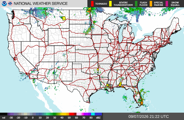
    National Weather Service CONUS radar mosaic showing current precipitation across the United States
    NWS CONUS radar mosaic. Public domain.

    These are the events that generate the restoration work crews actually see: wind-driven roof and siding failures, hail-pocked windows and vehicles, downed trees on service lines, and interior flooding from 2–3 inches in an hour on poorly drained streets. Conditions change fast. Verify with the National Weather Service for the specific county or ZIP before you roll.

    What is live this afternoon

    The Storm Prediction Center 2000 UTC Day 1 outlook holds a Slight Risk of severe thunderstorms across parts of central North Dakota and southeast South Dakota into northeast Nebraska. The headline threat is large hail. A tornado or two is possible in southeast South Dakota. Isolated damaging wind is possible across a broader Marginal Risk from the northern and central Plains into the upper Mississippi Valley. Locally damaging wind gusts remain possible over the central Gulf Coast states.

    No convective watches are in effect as of this writing. Warnings are local Severe Thunderstorm Warnings and Special Weather Statements, plus flood advisories where storms stall.

    Hotspot 1 — Northern Plains: North Dakota, South Dakota, eastern Montana

    A shortwave coming off the northern Rockies is the organizer. SPC expects widely scattered severe storms capable of mainly large hail over northwest into central North Dakota and southeast South Dakota this afternoon into evening. Forecast soundings east of a sharpening dryline in central ND support supercell modes. Large hail is the primary restoration exposure. Isolated tornado risk is highest in southeast South Dakota.

    Official Local Storm Reports already on the board today include 62 mph near Midland, South Dakota; 73 mph west-southwest of Fort Pierre; 59 mph near Forestgrove, Montana; and 63 mph near Winnett, Montana. Overnight and early-morning reports from eastern Montana included estimated 2-inch hail near Shepherd in Yellowstone County, with broken windows and siding damage from wind-driven hail.

    Recent Severe Thunderstorm Warnings from NWS Glasgow have covered Garfield, McCone, Prairie, and Petroleum counties in northeastern Montana for radar-indicated 60 mph gusts. Weather Prediction Center Day 1 also carries a Slight Risk of excessive rainfall for a portion of northwestern Montana.

    Restoration read: hail and wind first. Check roofs, skylights, west- and south-facing windows, and vehicle lots. Trees and service drops follow the 60-plus mph cores.

    Hotspot 2 — Central Gulf Coast: Louisiana, Mississippi, Alabama, Florida Panhandle, far southeast Texas

    Hot, very moist air with MLCAPE in the 2500–3500 J/kg range is supporting scattered afternoon and evening storms. Shear is weak, so this is not a supercell outbreak. The threat is intense downdrafts and slow storm motion. WPC added a Marginal Risk of excessive rainfall from far southeastern Texas into southwestern Alabama and the western Florida Panhandle. Rainfall rates of 2–3 inches in an hour are possible where cells stall near the Texas–Louisiana border.

    Active and recent Severe Thunderstorm Warnings this afternoon have included St. Helena, Livingston, Tangipahoa, and West/East Feliciana parishes in southeast Louisiana (near Hammond, Natalbany, Zachary, Slaughter) and south-central Alabama into northwest Florida (Escambia, Santa Rosa, Conecuh — Brewton, Flomaton, Evergreen, Pollard). Hazard language has been 60 mph gusts and penny-size hail.

    Yesterday’s LSRs already showed the damage type: trees and power lines down near Philadelphia and Greenville, Mississippi, including a microburst with building damage in the Greenville area.

    Restoration read: wind and water, not a hurricane surge. Urban flooding and tree-on-roof jobs in the same zip codes as the warning polygons.

    Hotspot 3 — Florida and the coastal Southeast

    Southeast Florida has been firing strong storms through Labor Day afternoon. NWS and local offices have carried a Severe Thunderstorm Warning for southeastern Martin County with radar-indicated 60 mph gusts and penny hail, plus a Flood Advisory in east-central Palm Beach County after 2–3 inches of rain. Steering is weak; cells can dump on the same neighborhoods twice.

    Northeast Florida into coastal Georgia and southern South Carolina sits under an above-average precipitable-water axis. NWS Jacksonville has been issuing Special Weather Statements for Baker, Columbia, Alachua, Suwannee, and adjacent Georgia counties with 40 mph gusts. WPC notes high neighborhood probabilities for 2- and 3-inch rainfall totals along that coastal moisture axis.

    Restoration read: interior water and urban flooding first, then wind to trees and fascia. Metro Broward/Miami-Dade and the I-10 / I-75 corridors in north Florida are the places to watch hour by hour.

    Pulse table

    RegionMain threatsSPC / WPC levelStatus this afternoon
    Central ND / SE SD / NE NELarge hail, damaging wind, isolated tornadoSlightDeveloping afternoon–evening
    Eastern MT / northern PlainsDamaging wind, hailMarginal + local SVR warningsActive
    Gulf Coast LA–AL–FL PanhandleDamaging wind, flash flood pulsesMarginal + local SVR warningsActive
    SE / NE Florida + coastal GA/SCHeavy rain, gusty wind, urban floodingLocal severe / flood advisoriesActive
    Atlantic tropics vs. U.S. coastNoneNo tropical cycloneQuiet

    What this is not

    This is not a regional derecho and not a hurricane landfall. No watches are up. The work, if it comes, will be scattered: a hail swath through a Dakota county, a microburst block in Louisiana or Alabama, a flooded intersection in Palm Beach or Jacksonville. That is the local-storm pattern restoration desks should staff for tonight.

    Sources and how to verify

    Primary sources: NOAA Storm Prediction Center Day 1 Convective Outlook issued 0259 PM CDT Monday, September 7, 2026; SPC today’s storm reports; Weather Prediction Center Day 1 Excessive Rainfall Outlook; National Hurricane Center Atlantic Tropical Weather Outlook (no tropical cyclone formation expected in the next 7 days); and active NWS warning text from Glasgow MT, New Orleans LA, Mobile AL, Jacksonville FL, and West Palm Beach-area offices.

    Check weather.gov for the county warning, spc.noaa.gov for the outlook and LSRs, and local radar before you treat any polygon as a job ticket. This desk will update when the evening reports close.