Quick Answer: The Colby Club (2823 Colby Ave, former downtown Starbucks) is a Prohibition-era cocktail speakeasy opened October 2023 by Karen Taylor and Robert Penrose. Classic cocktails, creative mocktails, small plates. Hours: Mon–Sat 4pm–midnight, Sun 4pm–10pm.
Two Years In, The Colby Club Is Still Downtown Everett’s Best Cocktail Secret. Time to Stop Keeping It One.
You know the feeling: you walk past a place a hundred times, don’t go in, finally do, and feel genuinely foolish for waiting. That’s The Colby Club at 2823 Colby Ave in downtown Everett — the former Starbucks location, which tells you absolutely nothing about what it became.
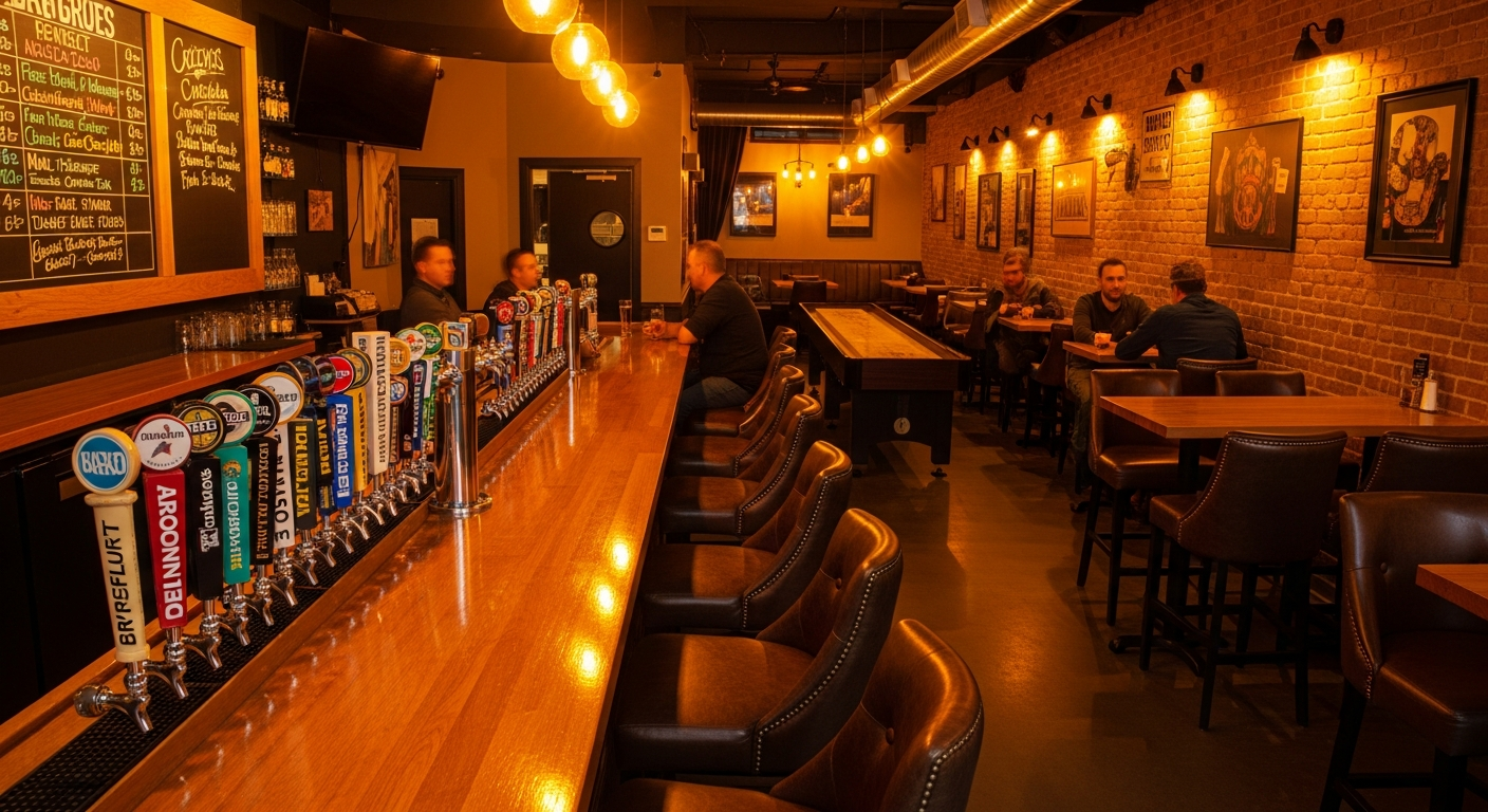
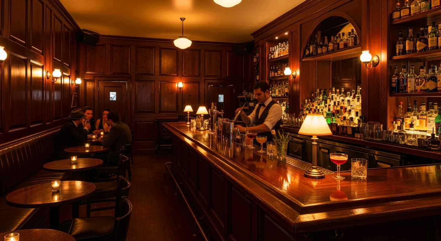
In October 2023, Karen Taylor and Robert Penrose converted that coffee chain space into one of the most considered cocktail bars in the city. Robert renovated every corner of it himself — choosing dark wood, low lighting, and materials that communicate Prohibition-era without costuming it. Through the wide front windows, you can watch the activity on Colby Avenue and feel completely removed from it at the same time. The result is a room that makes you want to stay.
Two years in, weekend evenings are reliably full. The bar fills without becoming a scene. The conversation stays at conversation volume. The cocktails are made correctly. If you haven’t been, this is your notice.
Who’s Behind It
Karen Taylor and Robert Penrose are married, which is either a great way to run a hospitality business or a very challenging one. In their case, it’s working. Before Everett, they spent four years operating Revival Lounge in downtown Mount Vernon — learning what it takes to run a craft cocktail bar in a smaller Washington city that doesn’t always expect one. That experience shows at The Colby Club. It doesn’t have the rough edges of a first venture.
Karen developed several of the original house cocktails. Robert handled the physical renovation of the space. The division of labor produced something that works from both the inside and outside of the glass.
The Cocktail Program: What to Drink
The Colby Club does classic cocktails with proper technique and without pretension. Order an Old Fashioned and you get an Old Fashioned that tastes like an Old Fashioned — not a riff, not a reinvention, not a cocktail that requires a paragraph of explanation. Order from the house list and you’ll get something unexpected that still makes complete sense.
The Flapper is the signature Karen Taylor original — her description is “sweet but balanced,” and that’s accurate. It’s the drink to start with if you haven’t been before. The Rhubarb Flip is built on gin and is the kind of cocktail that surprises people who didn’t expect to like a gin drink. Both are the sort of thing that tells you within one sip whether a bar knows what it’s doing. These do.
The mocktail program — called the teetotaler menu — receives the same care and creativity as the full bar list. Mocktail menus are increasingly common; mocktail menus that actually taste good and make you feel like you got the same experience as everyone else at the table are still rarer than they should be. The Colby Club’s version earns its place on the menu. If you’re not drinking, you’re not missing out.
Draft beers and wine round out the program for anyone who arrives with different preferences. The bar doesn’t force the cocktail on you. It just does cocktails best.
The Food: Small Plates, Correctly Calibrated
The food program is intentionally compact — small plates designed to accompany drinks, not replace dinner. The anchors are Beecher’s classic mac (around $16) and flatbread pizzas (roughly $13–14). Beecher’s Handmade Cheese is a Pacific Northwest institution, and the mac served warm here is exactly the kind of thing that makes you order a second cocktail without noticing you’ve done it. The flatbreads are solid. Prices may vary; check with the bar on current offerings.
The food doesn’t overpromise. That’s the right call. If you want a full dinner, R Harn Thai a few blocks east on Hewitt will sort you out. Come to The Colby Club for drinks and let the small plates do what they’re designed to do.
The Room: What the Renovation Built
Rob Penrose renovated the former Starbucks space himself — hands-on, not hired-out. The low lighting is doing real work. The dark wood communicates without being theatrical. The seating is intimate without being cramped. There’s enough room that you can have a private conversation, not so much that the place feels like a performance space.
The Colby Club doesn’t have a rooftop or a water view. It has a room that earns your attention through craft and atmosphere rather than setting. That’s a harder thing to pull off, and they’ve pulled it off.
Where the Colby Club Fits in Everett’s Cocktail Scene
Everett’s cocktail and bar scene has developed unevenly but meaningfully. The Muse Whiskey & Coffee at 615 Millwright Loop W on the waterfront does a whiskey-forward evening program inside a restored 1923 Weyerhaeuser building. Obsidian Beer Hall at 1420 Hewitt Ave does curated PNW beer in an elegant room. The Ten-01 Pub at 1001 Hewitt does a community bar in a 1907 building with train beers.
The Colby Club fills a different niche: proper craft cocktails in a room that takes the atmosphere as seriously as the drinks, in the middle of downtown, open seven nights a week. If cocktails are the goal, The Colby Club is where you go. That’s been true for two years.
What to Order
The Flapper — Karen Taylor’s signature. Sweet but balanced. Start here on your first visit.
Rhubarb Flip — Gin-based. Better than it sounds if you’re not a gin drinker.
Any classic cocktail — Made correctly. That’s worth more than you’d think.
Teetotaler mocktail — The real option if you’re driving or dry. Same care, different ingredient list.
Beecher’s mac — Order it to share, or don’t share it. Both are defensible choices.
The Logistics
- Address: 2823 Colby Ave, Everett WA 98201 (former Starbucks location, downtown)
- Hours: Monday–Saturday 4pm–midnight | Sunday 4pm–10pm
- Instagram: @thecolbyclub
- Walk-ins: Welcome; no reservation required
- Parking: Street parking on Colby Ave; downtown garage on Colby walkable
- Price range: $$ — craft cocktail pricing; small plates roughly $13–$16
Frequently Asked Questions
When did The Colby Club open?
October 2023, in the former Starbucks space at 2823 Colby Ave in downtown Everett.
Who owns The Colby Club?
Karen Taylor and Robert Penrose, who are married. They also operate Revival Lounge in downtown Mount Vernon, WA.
Does The Colby Club serve food?
Yes — small plates. Beecher’s classic mac and flatbread pizzas are the main options. The food complements drinks rather than serving as a full dinner.
What is The Flapper cocktail at The Colby Club?
The Flapper is a signature cocktail created by owner Karen Taylor — described as sweet but balanced. It’s the recommended first drink for new visitors.
Does The Colby Club have a mocktail menu?
Yes — the “teetotaler” menu is a dedicated non-alcoholic cocktail list that receives the same craft attention as the full bar program.
Is The Colby Club good for a date night?
Yes. The intimate atmosphere, low lighting, and well-made cocktails make it a strong date night option in downtown Everett.
What is the parking situation at The Colby Club?
Street parking on Colby Avenue and the nearby downtown Everett parking garage on Colby, which is walkable to the bar.
Is The Colby Club open on Sunday?
Yes — Sunday 4pm–10pm. Open seven nights a week total.