Author: William Tygart

  • Every Retirement Facility Should Be a Library

    Every Retirement Facility Should Be a Library

    Every Retirement Facility Should Be a Library


    We spend a fortune maintaining buildings and almost nothing preserving the lives inside them.

    Think about any retirement facility you’ve ever walked into. A hundred residents. A hundred careers, marriages, wars survived, businesses built, children raised, mistakes made and learned from. Centuries of lived knowledge under one roof — and when those residents pass, almost all of it goes with them. Not because nobody cared. Because nobody built the shelf.

    I’ve been calling the answer the wisdom trust: a captured life, left behind like a 401k. Not money — proof. This was a life that was lived, and here’s what it taught.

    Why now

    The technology to capture a life story has existed for years. Voice cloning, chatbots, digital twins you can question forever — the demos are dazzling and mostly beside the point.

    The real breakthrough is much dumber, and much more important: there’s finally an onboarding pattern simple enough for an 85-year-old.

    The pattern that works looks like this: a family member (the “archivist”) sends a question by email. The elder (the “storyteller”) clicks one link and lands in a chat. No app to install. No account to create. They type or they talk — twenty-plus languages — and each story saves to the family’s encrypted vault. That’s it. That’s the whole unlock.

    A company called Aeterna recently productized exactly this with their “Send a Question” feature, and whatever you think of their wilder claims (an interactive twin you can talk to forever — company claim only, no independent test yet), the onboarding fix is real and it’s the part that matters. The ceiling just became the floor: the hard part was never the AI, it was getting a grandmother to tap one link.

    The facility is the venue

    Here’s the part nobody’s saying: the natural home for this isn’t an app store. It’s the retirement facility.

    Facilities already have the residents, the trust relationships, the activities programming, and the family touchpoints. What they don’t have is a story worth telling at move-in — something beyond square footage and dining menus. Imagine touring two facilities and one of them says: “Every resident here gets their life captured. Your mother’s stories, in her voice, preserved for your grandchildren. It’s part of living here.”

    That’s not an amenity. That’s a reason to choose.

    The cost per resident is low — a link, a few prompts, staff time folded into activities programming they already run — and the perceived value to families is enormous. It differentiates the facility, deepens family loyalty, and creates the kind of word-of-mouth no ad budget buys. (I’m not going to put a hard dollar figure on it; the honest version is that the expensive parts are the ones facilities already pay for.)

    The machine-readable half

    Here’s the part I’m most excited about, and it’s the reason this kit looks the way it does.

    We make books and videos so other humans can understand and act. But a wisdom trust isn’t really a book for humans — it’s a book for bots. A machine needs to be able to pick up a resident’s captured life and do work with it: build the timeline, cut the quote cards, draft the family digest, notice what’s missing and ask the next question.

    So the kit ships with a second half most open-source starter kits don’t have: a plug-in contract for AI. In the `automation/` folder you’ll find the whole thing — and it reads like a book’s anatomy:

    • README = the cover letter. Tells any AI what this collection is, what state it’s in, and where to start.
    • Pipeline = the table of contents. Eight stages, from raw audio to a curated collection: ingest, clean, segment, enrich, render, digest, gallery, and gap-scan.
    • Schemas = the grammar. JSON schemas for every bucket — stories, timeline events, quote cards, people, places, artifacts — so the machine files things the same way every time.
    • Prompts = the instructions. Copy-paste prompts for each stage, written so a different model next year can run the same pipeline.
    • Worked example = “see, like this.” One resident’s collection, filled in, showing what “done” looks like.

    Human-readable enough to trust. Machine-readable enough to run.

    The provenance rule

    One rule governs everything the machine makes, and it’s non-negotiable:

    Every generated artifact — an illustration, a song, a video, a voice reading — must carry three things: what it is, what it is not, and why it was made. The why is the thinking that connected the source story to that form, and it’s part of the heirloom. A grandchild shouldn’t just see a painting of a drugstore; they should read that it was painted because their great-grandmother’s story mentioned the store but no photograph of it survived — and that it is not a photograph of the actual place.

    The machine curates. The family decides. Weekly letters stay drafts until a human approves them — nothing auto-sends, ever.

    The kit (open source)

    I’m not building a company around this. I’m making the seed and putting it on the shelf.

    I’ve published an open-source starter kit — wisdom-trust-in-a-box — with everything a facility or a builder needs to pilot it:

    • A question library: forty prompts across a life (childhood, work, love, hard times, wisdom)
    • The one-link onboarding flow, with a staff script and a family email template
    • A plain-language consent template (the elder owns their stories, period)
    • A one-page pilot brief a facility director can read in three minutes
    • The economics: why a facility wants this, in one page

    Fork it. Pilot it. Improve it. Tell me how it goes.

    The ask

    I’m good at making seeds. I’m not going to be the gardener on this one — that’s not false modesty, it’s knowing my lane.

    So this is the handoff: the kit is on the shelf, the pattern is written down, and the onboarding problem that blocked all of this for a decade finally has a working pattern worth copying. Somebody’s going to be the first facility that does this the way they all have Wi-Fi now.

    Might as well be yours.

  • Flash Flood Warning: Brewster & Pecos Counties, TX Area Until 8:15 PM CDT

    Flash Flood Warning: Brewster & Pecos Counties, TX Area Until 8:15 PM CDT

    This is a live snapshot as of Saturday, September 19, 2026, at about 4:35 PM PDT (6:35 PM CDT). Conditions change fast — always verify with the National Weather Service for your specific county or ZIP code.

    The National Weather Service in Midland/Odessa has issued a Flash Flood Warning for north central Brewster County and south central Pecos County, Texas, in effect until 8:15 PM CDT tonight. Doppler radar indicated thunderstorms producing heavy rain across the warned area, with 1 to 2 inches of rain already fallen and expected rainfall rates of 2 to 3 inches per hour. The NWS classifies the hazard as life-threatening flash flooding of creeks and streams, urban areas, highways, streets and underpasses — damage threat rated CONSIDERABLE. For restoration teams across far west Texas, this is a rural-drainage event: dozens of named creeks and draws are in the warned path, and ranch and rural structures along them are the first to take water.

    Brewster & Pecos Counties, TX — Flash Flood Warning

    Issued by: NWS Midland/Odessa TX · Issued: 6:17 PM CDT, September 19 · Expires: 8:15 PM CDT, September 19

    Hazard detail, per the NWS alert:

    • At 6:17 PM CDT, Doppler radar indicated thunderstorms producing heavy rain across the warned area.
    • Between 1 and 2 inches of rain have fallen. The expected rainfall rate is 2 to 3 inches in 1 hour.
    • Flash flooding is ongoing or expected to begin shortly.
    • Hazard: life-threatening flash flooding. Thunderstorms producing flash flooding.
    • Source: radar indicated.
    • Impacts: life-threatening flash flooding of creeks and streams, urban areas, highways, streets and underpasses.

    Named locations: mainly rural areas of north central Brewster and south central Pecos Counties.

    Streams and drainages in the warned area: Negro Creek, Big Canyon, Pea Blanca Creek, Wood Hollow Creek, San Francisco Creek, Dry Creek, Spring Creek, Pyle Draw, Nineteen Draw, Maravillas Canyon, Downie Draw, Willow Creek, Pea Colorado Creek and Indian Creek.

    Issuing office: NWS Midland/Odessa. Alert source: NWS API alerts feed.

    NWS instructs: “Turn around, don’t drown when encountering flooded roads. Most flood deaths occur in vehicles.” They also ask residents to “report observed flooding to local emergency services or law enforcement and request they pass this information to the National Weather Service when you can do so safely.”

    Stay safe tonight

    Flood water is never just water. Most flood deaths occur in vehicles — never drive through a flooded roadway, and never trust a water-covered dip in the road: it takes only a foot or two of moving water to carry a car. In far west Texas, ranch roads cross draws and low-water crossings constantly, and with rainfall rates of 2 to 3 inches per hour, those crossings can go from passable to impassable between trips. If you are traveling tonight, know your route’s crossings and assume any water over the road is too deep.

    If water enters a home or building: stay out of standing water where electricity may be present; avoid basements or below-grade rooms until water recedes and power is confirmed off; photograph everything before cleanup (documentation matters for insurance); then call a local restoration contractor — water left sitting starts a second wave of damage within a day. Ranch outbuildings, equipment sheds, and low-lying residences along the named creeks are the most exposed tonight.

    What this means for restoration teams

    This warning profile — 1 to 2 inches already down, another 2 to 3 inches per hour possible, flooding of creeks, streams, highways, streets and underpasses across north central Brewster and south central Pecos counties — translates into a specific rural damage pattern. Expected loss profile over the next 12–48 hours:

    • Interior water intrusion at ranch homes, outbuildings, and rural residences along Negro Creek, Big Canyon, Maravillas Canyon, and the other named drainages.
    • Saturated drywall and insulation where water enters at grade; slab-on-grade homes take it through door seals and low vents.
    • Mold risk within 24–48 hours on saturated materials in warm, humid post-storm air.
    • Contamination questions where floodwater carries agricultural runoff, septic, or petroleum — document water source on intake, since category determination changes the job.
    • Access constraints: crews should expect washed-out ranch roads and low-water crossings to complicate reach for the first 24 hours.

    The play: stage equipment now, pre-position drying assets before the evening call window, keep an on-call rotation through the morning, and capture address + water source + affected areas on the first call — access directions matter here, since many addresses will be ranch roads off ranch roads. Field discipline: photo-document before mitigation, moisture-map every affected room, keep the homeowner’s payment responsibility clear in writing before work starts. Rural calls tend to lag urban ones by a day or more as property owners discover damage on their next visit — keep intake open through midweek.

    FEMA & federal assistance

    If the damage proves significant, the federal route is standard: the FEMA Helpline is 1-800-621-3362 (7 a.m.–10 p.m. local, 7 days). You can also apply at DisasterAssistance.gov, through the FEMA app, or find a recovery center at fema.gov/drc. Basic eligibility: citizenship or qualified status, identity verification, proof of occupancy or ownership, and unmet needs not covered by insurance. Apply as soon as it is safe — don’t wait for water to finish draining.

    Looking ahead

    This warning expires at 8:15 PM CDT. But expiry is not the all-clear: with 2-to-3-inch-per-hour rainfall rates, the named creeks and draws will keep running high after the warning drops, and additional rounds of storms can trigger fresh warnings for the same counties. Watch for the Midland/Odessa NWS office to update as cells move through the evening; the next NWS update lands with any new warning or when conditions change.

    Demand window: water-intrusion calls typically start within hours of water receding and keep coming for days as people discover damage. For rural Brewster and Pecos counties, where owners may not visit affected properties until Sunday or Monday, restoration teams serving Alpine, Marathon, Fort Stockton and the wider Permian edge should expect a slower-starting but persistent intake window through next week.

    Sources & how to verify

    To verify for your own county or ZIP: check weather.gov, enter your location, or visit the issuing NWS office page linked above.

    This post is for informational purposes and is not an official weather warning. Always follow instructions from local authorities and the National Weather Service.

  • Flash Flood Warning: Sierra County, NM Area Until 7:15 PM MDT

    Flash Flood Warning: Sierra County, NM Area Until 7:15 PM MDT

    This is a live snapshot as of Saturday, September 19, 2026, at about 4:35 PM PDT (5:35 PM MDT). Conditions change fast — always verify with the National Weather Service for your specific county or ZIP code.

    The National Weather Service in El Paso/Santa Teresa has issued a Flash Flood Warning for Sierra County, New Mexico, in effect until 7:15 PM MDT today. Doppler radar indicated thunderstorms producing heavy rain across the warned area, with between 2.5 and 3.5 inches of rain already fallen. The NWS classifies the hazard as life-threatening flash flooding of creeks and streams, urban areas, highways, streets and underpasses — and damage threat is rated CONSIDERABLE. For restoration teams in southern New Mexico, this is the pattern that produces the worst surprises: water continuing to drain through canyons and arroyos long after the rain itself has stopped.

    Sierra County, NM — Flash Flood Warning

    Issued by: NWS El Paso Tx/Santa Teresa NM · Issued: 5:17 PM MDT, September 19 · Expires: 7:15 PM MDT, September 19

    Hazard detail, per the NWS alert:

    • At 5:17 PM MDT, Doppler radar indicated thunderstorms producing heavy rain across the warned area.
    • Between 2.5 and 3.5 inches of rain have fallen. Flooding impacts will continue, but no additional rainfall is expected.
    • Flash flooding is ongoing or expected to begin shortly.
    • Hazard: life-threatening flash flooding. Thunderstorms producing flash flooding.
    • Source: radar indicated.
    • Impacts: life-threatening flash flooding of creeks and streams, urban areas, highways, streets and underpasses.

    Named locations: Alamosa Canyon is specifically called out. The NWS notes water may take some time to drain through canyons and arroyos toward upper Lake Shore Road and Elephant Butte Reservoir.

    This warning (VTEC /O.CON.KEPZ.FF.W.0151) remains in effect for north central Sierra County. It follows an earlier Sierra County warning covering northwest portions of the county through 5:45 PM MDT — this is a separate alert for north central Sierra County with its own expiry.

    Issuing office: NWS El Paso / Santa Teresa. Alert source: NWS API alerts feed.

    NWS instructs: “Turn around, don’t drown when encountering flooded roads. Most flood deaths occur in vehicles.” And: “Be aware of your surroundings and do not drive on flooded roads.”

    Stay safe this evening

    Flood water is never just water. Most flood deaths occur in vehicles — never drive through a flooded roadway, and never trust a water-covered dip in the road: it takes only a foot or two of moving water to carry a car. In the desert Southwest, arroyos and normally-dry canyons are the highest risk: they can go from dust to raging currents in minutes from rainfall that fell miles away and minutes earlier.

    If water enters a home or building: stay out of standing water where electricity may be present; avoid basements or below-grade rooms until water recedes and power is confirmed off; photograph everything before cleanup (documentation matters for insurance); then call a local restoration contractor — water left sitting starts a second wave of damage within a day. In Sierra County specifically, with water draining toward Elephant Butte Reservoir, watch low-lying roads and crossings even where skies look clear: the drain-down continues after the rain stops.

    What this means for restoration teams

    This warning profile — 2.5 to 3.5 inches of rain, life-threatening flooding of creeks, streams, urban areas, highways, streets and underpasses — is the classic interior water-intrusion package for this part of southern New Mexico. Expected loss profile over the next 12–48 hours:

    • Interior water intrusion at low-lying structures near Alamosa Canyon, upper Lake Shore Road, and drainage routes toward Elephant Butte Reservoir.
    • Saturated drywall and insulation where water enters at grade or through garage doors and low windows.
    • Mold risk within 24–48 hours on anything wet that isn’t dried properly — desert heat speeds microbial growth on saturated organic materials.
    • Contamination questions where floodwater mixes with septic, agricultural runoff, or roadway chemicals — document source on intake.

    The play: stage equipment now, pre-position drying assets before the evening call window, keep an on-call rotation through the morning, and capture address + water source + affected areas on the first call. Field discipline: photo-document before mitigation, moisture-map every affected room, keep the homeowner’s payment responsibility clear in writing before work starts. Water from a draining canyon system keeps arriving after the warning expires — teams should expect the first calls tonight and a second wave of discovered damage tomorrow and Monday.

    FEMA & federal assistance

    If the damage proves significant, the federal route is standard: the FEMA Helpline is 1-800-621-3362 (7 a.m.–10 p.m. local, 7 days). You can also apply at DisasterAssistance.gov, through the FEMA app, or find a recovery center at fema.gov/drc. Basic eligibility: citizenship or qualified status, identity verification, proof of occupancy or ownership, and unmet needs not covered by insurance. Apply as soon as it is safe — don’t wait for water to finish draining.

    Looking ahead

    This warning expires at 7:15 PM MDT. But expiry is not the all-clear: the NWS specifically notes water will take time to drain through canyons and arroyos toward upper Lake Shore Road and Elephant Butte Reservoir, meaning crossings and low roads can remain dangerous — and still be flooding structures — after the warning drops. Watch for additional rounds: Doppler radar indicated the heavy rain, but the storm pattern behind this evening’s cells determines whether a fresh warning follows. The next NWS update lands with any new warning or when conditions change.

    Demand window: water-intrusion calls typically start within hours of water receding and keep coming for days as people discover damage. Restoration teams serving Truth or Consequences, Elephant Butte, and surrounding Sierra County communities should treat tonight as intake-prep and the next 72 hours as the working window.

    Sources & how to verify

    To verify for your own county or ZIP: check weather.gov, enter your location, or visit the issuing NWS office page linked above.

    This post is for informational purposes and is not an official weather warning. Always follow instructions from local authorities and the National Weather Service.

  • Flash Flood Warning: Sierra County, NM Area Until 5:45 PM MDT

    Flash Flood Warning: Sierra County, NM Area Until 5:45 PM MDT

    This is a live snapshot as of Saturday, September 19, 2026, at about 4:20 PM PDT (5:20 PM MDT). Conditions change fast — always verify with the National Weather Service for your specific county or ZIP code.

    The National Weather Service in El Paso/Santa Teresa has issued a Flash Flood Warning for Sierra County, New Mexico, in effect until 5:45 PM MDT today. Doppler radar indicated thunderstorms producing heavy rain across the warned area, with up to 1.5 inches of rain fallen. Flash flooding is ongoing or expected to begin shortly — and NWS stresses that flooding impacts will continue even though no additional rainfall is expected. For restoration teams in southern New Mexico, this is the classic arroyo-flash pattern: water surging through low crossings and into low-lying structures long after the rain stops falling overhead.

    Sierra County, NM — Flash Flood Warning

    Issued by: NWS El Paso Tx/Santa Teresa NM · Issued: 5:01 PM MDT, September 19 · Expires: 5:45 PM MDT, September 19

    Hazard detail, per the NWS alert:

    • At 5:01 PM MDT, Doppler radar indicated thunderstorms producing heavy rain across the warned area.
    • Up to 1.5 inches of rain have fallen. Flooding impacts will continue, but no additional rainfall is expected.
    • Flash flooding is ongoing or expected to begin shortly.
    • Hazard: flash flooding caused by thunderstorms.
    • Source: radar indicated.
    • Impacts: flash flooding of small creeks and streams, urban areas, highways, streets and underpasses as well as other poor drainage and low-lying areas.

    Named locations: mainly rural areas of northwestern Sierra County.

    NWS instructs: “Turn around, don’t drown when encountering flooded roads. Most flood deaths occur in vehicles.” They add a line worth repeating verbatim: “Remain alert for flooding even in locations not receiving rain. Arroyos, streams, and rivers can become raging killer currents in a matter of minutes, even from distant rainfall.”

    This is a continuation of the same Sierra County flash flood event (VTEC /O.CON.KEPZ.FF.W.0150) — the warning remains in effect for northwestern Sierra County through 5:45 PM MDT.

    Stay safe this evening

    Flood water is not just water. Most flood deaths occur in vehicles — never drive through a flooded roadway, and never trust a water-covered dip in the road: it takes only a foot or two of moving water to carry a car. In the desert Southwest, arroyos and normally-dry washes are the highest risk: they can go from dust to raging currents in minutes from rainfall that fell miles away.

    If water enters a home or building: stay out of standing water where electricity may be present; avoid basements or below-grade rooms until water recedes and power is confirmed off; photograph everything before any cleanup begins — that documentation is what insurance claims and restoration scopes are built on. Then call a local restoration contractor. Water left sitting begins a second wave of damage within a day — wicking into drywall, soaking insulation, and starting the mold clock.

    If you’re driving in Sierra County tonight: turn around at any water-covered road. Find an alternate route. It is not worth the gamble.

    What this means for restoration teams

    This is the signature section — and this warning has a specific signature: rural flash flooding with no additional rainfall expected, but impacts continuing. That combination matters for how the demand unfolds.

    The damage categories to expect:

    • Interior water intrusion in low-lying and rural structures — water entering through doors, vents, and low foundation points rather than roofs. Ground-level commercial buildings and outbuildings are especially exposed.
    • Saturated drywall, baseboards, and insulation — with 1.5 inches of rain fallen in a short burst, interior wicking in finished lower walls is the most common residential claim pattern.
    • Highway and underpass washouts — the alert explicitly names highways, streets, and underpasses; these create the infrastructure calls (culverts, access roads) that land on the same contractors.
    • Mold risk within 24–48 hours — Sierra County is high desert, but saturated interior materials in an occupied structure go biological fast, especially if the HVAC can’t be run safely.
    • Outbuildings, workshops, and storage structures — rural northwestern Sierra County has a lot of them, and they’re rarely on flood maps anyone consulted.

    The play for tonight:

    • Stage extraction and drying assets now — truck-mounted extractors, dehumidifiers, air movers. The demand from this pattern typically starts within hours of water receding.
    • Keep an on-call rotation through the evening and early morning. Rural callers report damage late — they check outbuildings after dinner, not before.
    • On the first call, capture: address, water source (ground intrusion vs. roof), affected areas and materials, and whether power is on. That intake discipline is what lets you sequence jobs when five calls come in the same hour.
    • Field discipline: photo-document before mitigation, moisture-map every affected room including adjacent walls, and keep the homeowner’s payment responsibility clear in writing before work starts. Flash flood water can carry silt and debris — that’s a different category discussion than clean-water intrusion, and it should be on the intake form, not discovered on day two.

    Local emergency contacts

    If you are in immediate danger, call 911. For Sierra County emergency management, reach the Sierra County, NM website and follow the emergency management links for current contact numbers and any shelter-in-place guidance. No unverified phone numbers are listed here — confirm the current duty number on the county site.

    FEMA & federal assistance

    If your property sustains serious flood damage, federal assistance may be available:

    • FEMA Helpline: 1-800-621-3362 (7 a.m.–10 p.m. local time, 7 days a week)
    • Online: DisasterAssistance.gov, the FEMA mobile app, or fema.gov/drc for Disaster Recovery Center locations

    Basic eligibility generally requires citizenship or qualified non-citizen status, identity verification, proof of occupancy or ownership, and unmet needs not covered by insurance. Apply as soon as it’s safe — you don’t need to wait for a disaster declaration to register for potential assistance.

    Looking ahead

    The warning expires at 5:45 PM MDT — but NWS is explicit that flooding impacts will continue even though no additional rainfall is expected. Water already in the arroyos and low crossings keeps moving after the sky clears. Creeks and streams in the warned area may continue to rise or hold elevated flows into the early evening.

    Restoration teams should expect the call window to open within hours of water receding and to keep coming for days as residents discover damage — especially in rural Sierra County, where outbuildings and low-lying structures may not be checked until daylight Sunday. Watch for any additional NWS updates: this is a continuation event (/O.CON.KEPZ.FF.W.0150), and NWS El Paso/Santa Teresa may extend or re-issue if upstream runoff keeps rising.

    Sources & how to verify

    To verify for your own county or ZIP: go to weather.gov, enter your ZIP or county, and check the active watches and warnings from your local NWS office.

    This post is for informational purposes and is not an official weather warning. Always follow instructions from local authorities and the National Weather Service.

  • Flash Flood Warning: North Central Sierra County, NM Until 7:15 PM MDT

    Flash Flood Warning: North Central Sierra County, NM Until 7:15 PM MDT

    Status: ACTIVE — a new flash flood warning with a CONSIDERABLE damage threat is in effect for north central Sierra County, New Mexico until 7:15 PM MDT. This is a live snapshot as of 4:00 PM PDT (5:00 PM MDT) on Saturday, September 19, 2026. Conditions change fast — always verify with the National Weather Service for your specific county or ZIP code.

    The National Weather Service in El Paso Tx/Santa Teresa issued a new Flash Flood Warning at 4:20 PM MDT for north central Sierra County in south central New Mexico, running until 7:15 PM MDT. This is the elevated-threat lane of tonight’s Sierra County storm activity: the NWS tags this warning with a “considerable” flash flood damage threat and calls the hazard “life threatening flash flooding.” The warning was pushed out over the Wireless Emergency Alert system — phones in the area got the alert directly.

    For restoration crews and homeowners in the warned area, this is the exact interior-flooding job class that water-intrusion calls spike on: flash water moving fast enough to enter structures, not just pond on pavement.

    North Central Sierra County — Flash Flood Warning (new, elevated threat)

    Issuing office: NWS El Paso Tx/Santa Teresa. Issued: 4:20 PM MDT. Expires: 7:15 PM MDT. VTEC identifier /O.NEW.KEPZ.FF.W.0151.

    What the radar shows: At 4:20 PM MDT, Doppler radar indicated thunderstorms producing heavy rain across the warned area. Between 2.5 and 3.5 inches of rain have fallen, with additional rainfall amounts of up to 1 inch possible. The NWS states flash flooding is ongoing or expected to begin shortly.

    Hazard (verbatim): “Life threatening flash flooding. Thunderstorms producing flash flooding.” Source: radar indicated. Damage threat: considerable.

    Impacts (verbatim): “Life threatening flash flooding of creeks and streams, urban areas, highways, streets and underpasses.”

    Locations that will experience flash flooding, per the NWS: Alamosa Canyon and South Monticello Campground.

    This new warning overlaps earlier Sierra County warnings from this afternoon — an extended flash flood warning for the same north central Sierra County area remains in effect separately until 6:00 PM MDT (up to 3 inches of rain fell in that polygon, with up to an additional inch possible). Tonight’s 7:15 PM warning is the higher-threat of the two, carrying the considerable damage-threat tag and the wireless emergency alert.

    The NWS wireless emergency alert text for this warning reads: “NWS: FLASH FLOOD WARNING this area til 7:15 PM MDT. Avoid flooded areas.” The extended text is blunt: “This is a dangerous and life-threatening situation. Do not attempt to travel unless you are fleeing an area subject to flooding or under an evacuation order.”

    NWS El Paso Tx/Santa Teresa office page

    Stay safe tonight

    Turn around, don’t drown. Most flood deaths occur in vehicles — never drive through flooded roadways, and do not drive on flooded roads at all tonight.

    Be aware of your surroundings, and remain alert for flooding even in locations not receiving rain. The NWS specifically calls this out for this terrain: arroyos, streams, and rivers can become raging killer currents in a matter of minutes, even from distant rainfall. Campgrounds and canyon areas like Alamosa Canyon are exactly the terrain where this happens.

    If water enters your home: stay out of standing water where electricity may be present, avoid the basement until water recedes and power is confirmed off, photograph everything before any cleanup (documentation matters for insurance), and then call a local restoration contractor — water left sitting starts a second wave of damage within a day.

    What this means for restoration teams

    A “considerable” damage-threat flash flood warning in canyon and campground terrain translates into a specific damage mix: interior water intrusion where structures sit in low drainages, saturated drywall and insulation in any structure that took water, mold risk building within 24–48 hours, sewage backup in low-lying areas, and debris carried by fast water complicating every job (ash, rock, and flood debris add contamination and more tear-out).

    The play: stage equipment now while the warning is active, pre-position drying assets, keep an on-call rotation through the morning, and capture address + water source + affected areas on the first call. Field discipline: photo-document before mitigation, moisture-map every affected room, and keep the homeowner’s payment responsibility clear in writing before work starts.

    The demand window: water-intrusion calls typically start within hours of water receding and keep coming for days as people discover damage — especially around campgrounds and rural canyon properties where a structure may sit unchecked until someone drives out to look. For crews, the Saturday-evening timing means staffing the phone through Sunday morning, not just tonight.

    Local emergency contacts

    Sierra County Emergency Management: Ryan Williams, 575-894-6215 (alt 575-740-7213), per the NM DHSEM county emergency manager list. Sign up for county alerts through TextMyGov — keywords published on the county site at sierraco.org. For flooding in progress, call 911.

    FEMA & federal assistance

    If your home or business takes damage: the FEMA Helpline is 1-800-621-3362 (7 a.m.–10 p.m. local time, 7 days a week). You can also apply at DisasterAssistance.gov, through the FEMA app, or find a recovery center at fema.gov/drc. Basic eligibility requires citizenship or qualified status, identity verification, proof of occupancy or ownership, and unmet needs not covered by insurance. Apply as soon as it’s safe.

    Looking ahead

    When this warning expires at 7:15 PM MDT, the hazard doesn’t go quiet instantly — creeks and arroyos can keep rising and crest after the rain stops, and additional rounds of thunderstorms are possible tonight. Watch for the next NWS update from the El Paso/Santa Teresa office, and treat any renewed heavy rain as an immediate flash flood signal given how much water has already fallen (2.5 to 3.5 inches).

    For restoration operators, tonight and Sunday morning are the intake window. Every hour of saturated standing water is an hour of compounding secondary damage — mold, swelling, wicking — so the value of a fast response call is highest in the first 24 hours after water recedes.

    Sources & how to verify

    • NWS alert: Flash Flood Warning, North Central Sierra County NM, issued 4:20 PM MDT, expires 7:15 PM MDT (NWS El Paso Tx/Santa Teresa) — read September 19, 2026.
    • Wireless Emergency Alert text issued with this warning — read September 19, 2026.

    To verify for your own county or ZIP code: enter your location at weather.gov, or check the El Paso/Santa Teresa NWS office page for the latest warnings.

    This post is for informational purposes and is not an official weather warning. Always follow instructions from local authorities and the National Weather Service. Restoration Intel will carry the operator-side read on this warning — queued for the morning review.

  • Flash Flood Warning: Northwestern Brewster County TX Until 7:15 PM CDT

    Flash Flood Warning: Northwestern Brewster County TX Until 7:15 PM CDT

    The National Weather Service in Midland/Odessa has issued a Flash Flood Warning for northwestern Brewster County in southwestern Texas, in effect until 7:15 PM CDT. Doppler radar indicated thunderstorms producing heavy rain across the warned area, with between 1 and 2 inches of rain already fallen and an expected rainfall rate of 1 to 2 inches in 1 hour. Flash flooding is ongoing or expected to begin shortly — exactly the kind of water event that puts interior flooding on restoration crews’ schedules by nightfall.

    This is a live snapshot as of 5:15 PM PDT on Saturday, September 19, 2026. Conditions change fast — always verify with the National Weather Service for your specific county or ZIP code.

    Northwestern Brewster County — Flash Flood Warning

    Issuing office: NWS Midland/Odessa TX. Issue time: 5:09 PM CDT. Expiry: 7:15 PM CDT.

    • Hazard: Flash flooding caused by thunderstorms.
    • Source: Doppler radar indicated.
    • Rainfall: Between 1 and 2 inches of rain have fallen. The expected rainfall rate is 1 to 2 inches in 1 hour.
    • Status: Flash flooding is ongoing or expected to begin shortly.
    • Impacts: Flash flooding of small creeks and streams, urban areas, highways, streets and underpasses, as well as other poor drainage and low-lying areas.
    • Locations that will experience flash flooding include: Mainly rural areas of northwestern Brewster County — including the streams and drainages of Antelope Draw, Moss Creek, Maravillas Canyon, and Dugout Creek.

    Brewster County is the largest county in Texas by area — bigger than some states — and its northwest corner is remote, rugged country. In that terrain, one to two inches of rain in an hour does not spread out; it concentrates in draws and canyons. Antelope Draw, Moss Creek, Maravillas Canyon, and Dugout Creek are exactly the kind of normally dry desert drainages that turn into walls of water with little warning, and rural low-water crossings can go from passable to impassable between one trip and the next.

    The full alert is published on the NWS site: Flash Flood Warning for Brewster County TX (alert ID 0c664247d34eb980f992713af6627068d5c4a8bd).

    Stay safe tonight

    • Turn around, don’t drown. Most flood deaths occur in vehicles. Never drive through flooded roadways — in desert-canyon country, water over a road can be far deeper and faster than it looks, and the roadbed itself may be gone underneath.
    • Do not attempt to cross flooded low-water crossings. Find an alternate route or wait it out.
    • If water enters your home: stay out of standing water where electricity may be present; do not go into flooded rooms until water has receded and power is confirmed off.
    • Photograph everything before cleanup begins. Documentation matters for insurance — damage that is torn out before it is photographed is damage that is hard to get paid for.
    • Then call a local restoration contractor. Water left sitting starts a second wave of damage — saturated materials, wicking, and microbial growth — within a day.
    • If you observe flooding, report it to local emergency services or law enforcement and ask them to pass the information to the National Weather Service when you can do so safely.

    What this means for restoration teams

    This is a rural-territory warning, and rural-territory warnings behave differently than city ones. Calls come from ranch houses, vacation properties, and small-town homes spread across enormous drive times — the triage question is not just what the job is, but whether you can reach it safely and whether it is worth rolling a truck before the water recedes. Capture on the first call: the caller’s exact location, the water source (creek overflow, road runoff, or water entering the structure itself), and which areas of the property are affected. A flooded outbuilding is a very different job than water through the living room.

    The damage categories this warning maps to:

    • Interior water intrusion: where draws and drainage paths meet structures — floors, lower walls, and the contents that sit on them.
    • Saturated drywall and insulation: with rainfall rates of 1 to 2 inches in an hour, wall cavities take water fast; plan for moisture-mapping every affected room rather than spot-checking one wall.
    • Mold risk within 24–48 hours: September heat in West Texas is a mold accelerant. The clock on microbial growth starts the moment the warning area’s structures get wet, not when the water leaves.
    • Debris and sediment in the structure: desert-runoff events carry mud, sand, and vegetation into buildings — contamination that raises the scope beyond a simple water extraction.
    • Road-access complications: washed-out rural roads and flooded low-water crossings can delay both the homeowner and your crew. Stage equipment on the safe side of known crossings when you can.

    The play: pre-position drying assets tonight so the first dry call goes out as soon as the warning lifts and roads are passable. Keep an on-call rotation through the evening, not just the morning — in remote counties, people often discover the damage when they get home at dusk. Photo-document everything before mitigation starts, moisture-map every affected room, and keep the homeowner’s payment responsibility clear in writing before work starts — rural jobs have long drive times and thin margins, and a handshake scope does not survive a surprise invoice.

    FEMA & federal assistance

    If the damage is beyond what insurance covers, federal help may be available:

    • FEMA Helpline: 1-800-621-3362, open 7 a.m.–10 p.m. local time, 7 days a week.
    • Apply online: DisasterAssistance.gov — or through the FEMA app.
    • In-person help: fema.gov/drc lists Disaster Recovery Centers.
    • Basic eligibility: U.S. citizenship or qualified status, identity verification, proof of occupancy or ownership, and unmet needs not covered by insurance. Apply as soon as it is safe to do so.

    Looking ahead

    The warning expires at 7:15 PM CDT. Watch for the next NWS update from Midland/Odessa around expiry — warnings in training-thunderstorm setups are frequently extended or reissued for adjacent counties, and today has already seen active flash flood warnings across West Texas, including Jeff Davis, Reeves, and Pecos counties. Even after this warning lifts, the named drainages — Antelope Draw, Moss Creek, Maravillas Canyon, Dugout Creek — can run high for hours after the rain stops, and desert soils shed water long after the radar goes quiet.

    The demand window: water-intrusion calls typically start within hours of water receding and keep coming for days as people discover damage — especially in rural areas where a ranch house may sit unchecked until someone drives out to look at it. For crews, the weekend timing means staffing the phone through Sunday morning, not just tonight.

    Sources & how to verify

    To verify for your own county or ZIP code: enter your location at weather.gov, or check the Midland/Odessa NWS office page for the latest warnings.

    This post is for informational purposes and is not an official weather warning. Always follow instructions from local authorities and the National Weather Service.

  • Flash Flood Warning: Sierra County, New Mexico Until 5:45 PM MDT

    Flash Flood Warning: Sierra County, New Mexico Until 5:45 PM MDT

    Live snapshot as of 3:05 PM PDT, Saturday, September 19, 2026. The National Weather Service in El Paso Tx/Santa Teresa has issued a Flash Flood Warning for northwestern Sierra County in south central New Mexico, in effect until 5:45 PM MDT tonight. At 3:47 PM MDT, Doppler radar indicated thunderstorms producing heavy rain across the warned area, with up to 1.3 inches already fallen and up to another inch possible — and flash flooding is ongoing or expected to begin shortly. In arroyo country, this is the pattern that turns a dry wash into a raging current in minutes. Conditions change fast — always verify with the National Weather Service for your specific county or ZIP code.

    Northwestern Sierra County — Flash Flood Warning

    The National Weather Service office in El Paso Tx/Santa Teresa issued this warning at 3:47 PM MDT. It runs until 5:45 PM MDT.

    The warning covers northwestern Sierra County in south central New Mexico. The hazard, in the NWS’s own words: flash flooding caused by thunderstorms. The source is radar indicated — Doppler radar showed thunderstorms producing heavy rain across the warned area, with up to 1.3 inches of rain fallen. Additional rainfall of up to 1 inch is possible in the warned area. Flash flooding is ongoing or expected to begin shortly.

    Locations in the flooding path, named in the alert: Monticello and Las Placitas.

    Expected impacts, per the NWS: flash flooding of small creeks and streams, urban areas, highways, streets and underpasses, as well as other poor drainage and low-lying areas. The NWS adds a pointed note for this terrain: arroyos, streams, and rivers can become raging killer currents in a matter of minutes, even from distant rainfall. Sierra County’s dry washes are built for exactly this — and so are the low-water crossings between rural properties.

    NWS El Paso Tx/Santa Teresa office page — weather.gov

    Stay safe tonight in Sierra County

    Turn around, don’t drown when encountering flooded roads. Most flood deaths occur in vehicles — never drive through flooded roadways. Stay especially clear of arroyo crossings tonight: in this country, a road that looks dry at 4 PM can carry a killer current by 4:15.

    The NWS’s own instruction: remain alert for flooding even in locations not receiving rain. It does not have to be raining where you are for a flash flood to arrive where you are.

    If water is entering your home:

    • Stay out of standing water where electricity may be present. Keep away from the basement or lowest level until the water recedes and the power is confirmed off.
    • Photograph everything before you touch it — documentation matters for insurance.
    • Then call a local restoration contractor. Water left sitting starts a second wave of damage within a day.

    Report observed flooding to local emergency services or law enforcement and ask them to pass it to the National Weather Service when you can do so safely.

    What this means for restoration teams

    A 1.3-inch-plus flash-flood event on northwestern Sierra County translates into a familiar rural-southwest damage profile:

    • Interior water intrusion — rural and ranch properties where runoff sheets across land and finds the low wall, the door threshold, the crawlspace vent.
    • Saturated drywall and insulation — flash flooding soaks materials fast; everything below the water line may need to come out.
    • Mold risk within 24–48 hours — September desert heat after a flood is mold’s favorite window. Fast extraction and dehumidification is the difference between a dry-out and a mold job.
    • Sediment and debris — arroyo water carries silt and debris that turns cleanup into a multi-day extraction, not just a dry-out.

    The play: stage equipment now. Pre-position pumps, air movers, and dehumidifiers so a crew can roll toward Monticello and Las Placitas the moment calls come in. Keep an on-call rotation through the evening — flash-flood damage calls peak after dark when people get home and find the water. On the first call, capture the address, the water source, and exactly which rooms are affected — that triage decides what goes on the truck.

    Field discipline: photo-document before mitigation starts, moisture-map every affected room, and keep the homeowner’s payment responsibility clear in writing before work begins.

    FEMA & federal assistance

    If the flooding damages your home, FEMA help may be available. Call the FEMA Helpline at 1-800-621-3362 (7 a.m.–10 p.m. local, 7 days a week), visit DisasterAssistance.gov, use the FEMA app, or find a recovery center at fema.gov/drc.

    Basic eligibility: citizenship or qualified status, identity verification, proof of occupancy or ownership, and unmet needs not covered by insurance. Apply as soon as it’s safe — you don’t need to wait for cleanup to start.

    Looking ahead

    This warning expires at 5:45 PM MDT — but arroyo flooding doesn’t punch out when the warning does. Watch tonight for additional thunderstorms building over the same terrain, and for creeks and washes to run later in the evening as runoff funnels out of the higher ground.

    Demand window note: water-intrusion calls typically start within hours of the water receding and keep coming for days as people discover damage. Ranch and rural homeowners may not find water in an outbuilding until morning. Check the NWS El Paso page for any extensions or new warnings before the night is over.

    Sources & how to verify

    • National Weather Service — Flash Flood Warning, northwestern Sierra County, NM (issued 3:47 PM MDT, expires 5:45 PM MDT, September 19, 2026), NWS El Paso Tx/Santa Teresa
    • NWS El Paso Tx/Santa Teresa office page

    To verify for your own county or ZIP: go to weather.gov, enter your ZIP code, and check the alerts box at the top of the page.

    This post is for informational purposes and is not an official weather warning. Always follow instructions from local authorities and the National Weather Service.

  • Flash Flood Warning: Pecos, Texas Until 6 PM CDT

    Flash Flood Warning: Pecos, Texas Until 6 PM CDT

    Live snapshot as of 3:05 PM PDT, Saturday, September 19, 2026. The National Weather Service in Midland/Odessa has issued a Flash Flood Warning for central Pecos County in southwestern Texas, in effect until 6:00 PM CDT tonight. At 5:00 PM CDT, Doppler radar indicated thunderstorms producing heavy rain across the warned area, with between 2 and 3 inches of rain already fallen — and flash flooding is ongoing or expected to begin shortly. This is exactly the kind of fast water that turns into interior flooding calls for restoration teams. Conditions change fast — always verify with the National Weather Service for your specific county or ZIP code.

    Fort Stockton and Central Pecos County — Flash Flood Warning

    The National Weather Service office in Midland/Odessa, Texas issued this warning at 5:00 PM CDT. It runs until 6:00 PM CDT — a short-fuse warning, which tells you everything about how quickly this water is moving.

    The warning covers central Pecos County in southwestern Texas. The hazard, in the NWS’s own words: flash flooding caused by thunderstorms. The source is radar indicated — Doppler radar showed thunderstorms producing heavy rain across the warned area, with 2 to 3 inches of rain fallen. Flash flooding is ongoing or expected to begin shortly.

    Locations in the flooding path, named in the alert: Fort Stockton and the Fort Stockton–Pecos County Airport.

    Expected impacts, per the NWS: flash flooding of small creeks and streams, urban areas, highways, streets and underpasses, as well as other poor drainage and low-lying areas. Fort Stockton sits at the convergence of I-10 and U.S. 285, so highway and underpass flooding is squarely on the table, along with urban flooding in town where poor drainage meets a fast 2-to-3-inch dump.

    NWS Midland/Odessa office page — weather.gov

    Stay safe tonight in Pecos County

    Turn around, don’t drown when encountering flooded roads. Most flood deaths occur in vehicles — never drive through flooded roadways. Water under an underpass can be far deeper than it looks, and six inches of fast-moving water can knock an adult off their feet; a foot or two can float a car.

    If water is entering your home:

    • Stay out of standing water where electricity may be present. Keep away from the basement until the water recedes and the power is confirmed off.
    • Photograph everything before you touch it — documentation matters for insurance.
    • Then call a local restoration contractor. Water left sitting starts a second wave of damage within a day.

    Report observed flooding to local emergency services or law enforcement and ask them to pass it to the National Weather Service when you can do so safely.

    What this means for restoration teams

    A 2-to-3-inch flash-flood hit on central Pecos County is the classic interior water-intrusion scenario. Tonight’s damage categories to expect:

    • Interior water intrusion — ground-level rooms, garages, and finished basements where poor drainage pushes water through doors and weep paths.
    • Saturated drywall and insulation — flash flooding soaks materials fast, and everything below the water line may need to come out.
    • Mold risk within 24–48 hours — West Texas heat accelerates growth. Getting water extracted and dehumidification running fast is the difference between a dry-out and a mold job.
    • Sewage backup in low-lying areas where overloaded drainage backs up into structures.

    The play: stage equipment now. Pre-position pumps, air movers, and dehumidifiers so a single crew can roll to Fort Stockton the moment a call comes in. Keep an on-call rotation through the evening, and on the first call capture the address, the water source, and exactly which rooms are affected — that triage decides what goes on the truck.

    Field discipline: photo-document before mitigation starts, moisture-map every affected room, and keep the homeowner’s payment responsibility clear in writing before work begins.

    FEMA & federal assistance

    If the flooding damages your home, FEMA help may be available. Call the FEMA Helpline at 1-800-621-3362 (7 a.m.–10 p.m. local, 7 days a week), visit DisasterAssistance.gov, use the FEMA app, or find a recovery center at fema.gov/drc.

    Basic eligibility: citizenship or qualified status, identity verification, proof of occupancy or ownership, and unmet needs not covered by insurance. Apply as soon as it’s safe — you don’t need to wait for cleanup to start.

    Looking ahead

    This warning expires at 6:00 PM CDT — but flash flooding doesn’t punch out when the warning does. Watch tonight for additional rounds of thunderstorms training over the same area, and for creeks and low-water crossings to crest later in the evening as runoff funnels downhill.

    Demand window note: water-intrusion calls typically start within hours of the water receding and keep coming for days as people discover damage. The calls made Sunday morning are the ones where fast Saturday-night response would have shrunk the scope. Check the NWS Midland/Odessa page for any extensions or new warnings before the night is over.

    Sources & how to verify

    • National Weather Service — Flash Flood Warning, central Pecos County, TX (issued 5:00 PM CDT, expires 6:00 PM CDT, September 19, 2026), NWS Midland/Odessa
    • NWS Midland/Odessa office page

    To verify for your own county or ZIP: go to weather.gov, enter your ZIP code, and check the alerts box at the top of the page.

    This post is for informational purposes and is not an official weather warning. Always follow instructions from local authorities and the National Weather Service.

  • The Missed Call You Pay for Twice

    The Missed Call You Pay for Twice

    Starting October 1, Google will charge you for the calls you don’t answer. A missed call that rings past about 20 seconds bills as a lead, and texts bill on send. Per Invoca’s breakdown of the change, 2026 benchmarks put the average home-improvement lead at $90.92.

    That’s the first bill. It’s itemized, and it stings.

    The second bill never shows up on an invoice.

    The first bill: $90 for the ring you missed

    The math is simple and brutal. Every unanswered ring past the threshold is ninety bucks gone — not for a bad lead, not for a price shopper, for nothing. Nobody called back. Nobody got helped. You paid for the privilege of missing it.

    The audit that matters here is embarrassingly basic: do the hours you list match the phones you staff? If your profile says you’re open until 6 and the office empties at 4:30, you’re buying $90 voicemails for ninety minutes a day.

    The second bill: the customer who stops calling

    Here’s the one Google can’t invoice you for. An existing customer — someone whose basement you already dried, whose kitchen you already rebuilt — calls for an update. “Where’s my tech?” “Did the adjuster call you back?” They get voicemail. They leave a message. Nobody triages it until tomorrow.

    They don’t complain. They just don’t become a repeat customer. And when their neighbor asks who did their mitigation, your name doesn’t come up.

    Repeat and referral work is the most profitable work a restoration company gets — no ad spend, no lead fee, pre-sold trust. Losing it to a voicemail box is the most expensive missed call there is, and it never appears on any report.

    The fix is triage, not more staff

    Most of these calls don’t need a human being — they need routing. A new lead needs a dispatcher, now. A status update needs whoever holds the job file, with the actual answer. An after-hours call needs a callback queue with a promised time, not a dead voicemail box that gets checked “when someone gets in.”

    Illustration of incoming call triage: new leads to dispatch, status updates to the tech, after-hours calls to a callback queue
    Triage, not voicemail: every ring gets routed somewhere with an owner — including after hours.

    This is the whole phone-first argument in one story. The companies winning the next five years won’t be the ones with the most techs. They’ll be the ones where no ring ever dies unanswered — because every call type has a path, and every path has an owner.

    The four-question audit

    1. Do your listed hours match staffed phones? Every gap is a $90 donation to Google.
    2. What happens to a call at 6:15 PM? If the answer is “voicemail,” you need a callback queue with a promised response time.
    3. Who owns status-update calls? If it’s “whoever picks up,” nobody owns it. Route them to the job file.
    4. When did you last mystery-call yourself? Call your own number after hours tonight. Whatever you hear is what your customers hear.

    October 1 just put a price tag on the first kind of missed call. The second kind was always expensive — now you have a reason to fix both.

  • Who Pays Before the Work: The Deposit Fight Every Restoration Job Faces

    Who Pays Before the Work: The Deposit Fight Every Restoration Job Faces

    It started in a Facebook group in Anderson, Indiana: homeowners trading notes on 25–50% deposits, contractors answering that $12–15K in rental gear has to sit on site before the drying starts. The same fight is happening in public, all over the internet, and it’s worth reading in the combatants’ own words.

    Illustration of a homeowner and contractor in a tug-of-war over a repair contract
    The deposit debate, illustrated: both sides are protecting themselves from the same thing — getting burned.

    Camp one: the contractors

    Entrepreneur Nick Ayala’s reel (13K likes, 250 comments) takes on the client who says “I’ll pay you when it’s done.” His argument: starting work without a deposit “makes the freelancer the client’s bank — fronting labor, materials, calendar time, and 100% of the risk for free.”

    “Makes the freelancer the client’s bank — fronting labor, materials, calendar time, and 100% of the risk for free.”
    — Nick Ayala, Instagram

    A contractor posting as ProWall Paints & Plaster admits he “used to think asking for 50% upfront was ‘crazy,’ but now understands it is necessary” — the deposit covers materials, labor, scheduling, and mobilization. And John at Bluestone Construction puts it the way only a contractor can: “You pay 100% for any item at Canadian Tire… Yet in home renos where he locks the door and has complete control, he thinks he doesn’t have to pay!!”

    Camp two: the homeowners

    The rebuttal is just as vivid. One homeowner’s Instagram rant is captioned “A fool, and his money will soon be parted” — he will not pay half before work starts, period. A Facebook post that drew 500 comments is just a screenshot of a text exchange titled “No Deposit = No Work”: the contractor demands 50% by Zelle, the customer replies “Oh no I don’t pay no until the work is completed” and “That is unsafe.”

    “Oh no I don’t pay no until the work is completed.”
    — a customer, in a 500-comment Facebook thread

    And the fear isn’t abstract — a Moreno Valley community post with 810 comments documents a painter who took 50% cash upfront, missed days, asked for rent money, and quit.

    The law has opinions too

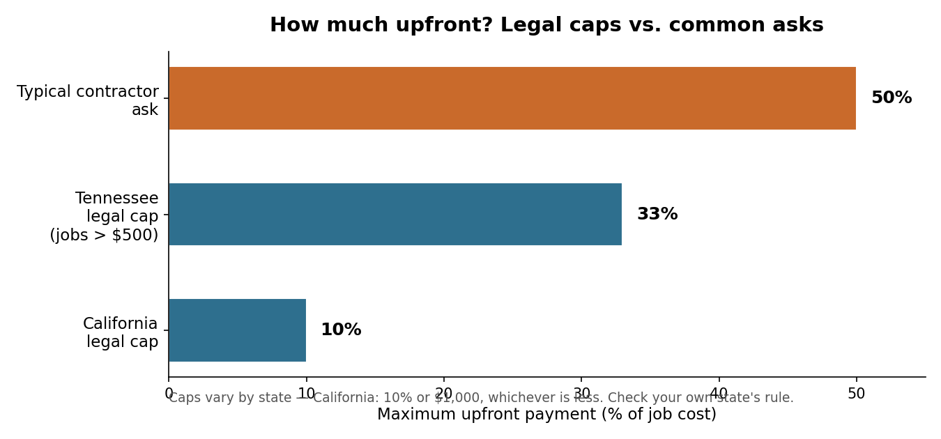
    Multiple states cap deposits by statute — California at 10% or $1,000, Tennessee at 33% for jobs over $500 — and UK prime minister Andy Burnham just weighed in on the same pattern (“take a big deposit, do half a job, then disappear”), backing escrow-style release: “Do the work, get paid. It’s as simple as that.”

    Bar chart comparing legal deposit caps in California (10%) and Tennessee (33%) against a typical contractor ask of 50%
    Legal caps vs. common asks. Caps vary by state — check your own state’s rule before you sign anything.

    Now the restoration spin

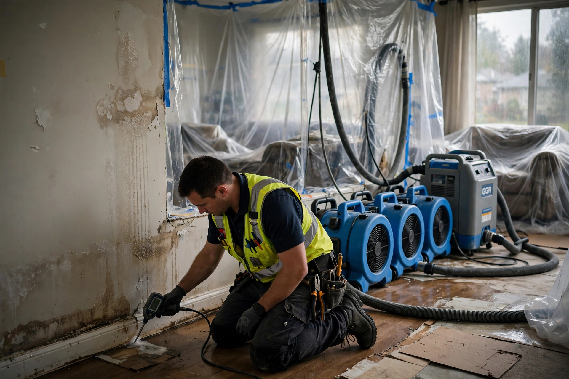
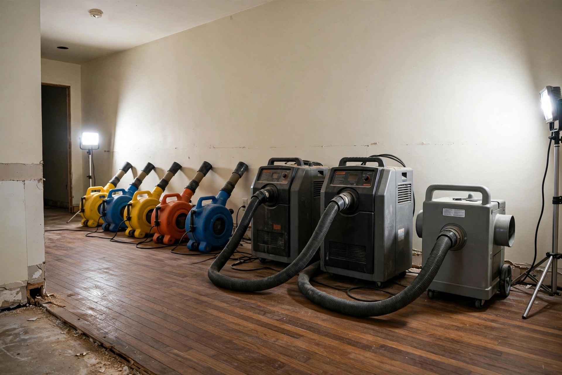
    This trade has a wrinkle the general debate misses. In restoration, the contractor’s number is real in a specific way: dehumidifiers, air movers, HEPA scrubbers, containment — the rental clock starts when the gear rolls off the truck, and a serious loss can mean twelve to fifteen grand of equipment sitting in your living room before the first board is cut. That’s mobilization cost, and a deposit against it is legitimate.

    Professional restoration drying equipment — air movers, dehumidifiers, and an air scrubber — lined up in a home
    Mobilization: this is what $12–15K of rental equipment looks like on day one — before the drying even starts.

    But here’s the part homeowners in that Anderson thread are really asking about: on an insured loss, the homeowner often isn’t the one paying — the carrier is. The deposit fight on a covered claim is about who fronts cash while the claim processes: the deductible, the first invoice, the gap between “work starts today” and “the check arrives in three weeks.” A good restoration contractor structures deposits around the claim, not against the homeowner.

    The middle ground

    Assembled from the sanest voices in these threads:

    • Tie the deposit to something real. A DIYnot commenter nailed it: “a reasonable deposit is the cost of the equipment to be installed plus the sundry materials.” In restoration, that means the deposit maps to mobilization — gear on site — not an arbitrary 50%.
    • Spell out the deposit rules in writing. Kevin Page on LinkedIn: “Spell out plainly whether the deposit is non-refundable, or exactly how it gets prorated if things end early.”
    • Pay by phase, not by percentage. A BiggerPockets investor: “You give some unscrupulous Contrs 1/3 up front and they’ll just take off.” His fix: invoice per phase, pay each phase in full when complete and inspected.
    • Remember who holds the leverage. “Whoever controls the money controls the job,” writes one builder — which is exactly why staged payments beat lump deposits. Money follows work.
    • Documentation is the tell. Daily moisture readings, psychrometric logs, photos at every stage. A contractor who documents is a contractor who finishes — and those are the same records your adjuster needs.

    The deposit isn’t the problem. The missing paperwork is. Both camps in this fight want the same thing — to not get burned — and the industry just hasn’t made the middle ground standard yet.