Loading…
Tag: Washington State
-

Tacoma Power’s Clean Energy Buildout: Cushman II Turbines, EV Charging Expansion, and the Green Hydrogen Rate Reshaping Pierce County
If you spend any time tracking Pierce County’s economic development conversations, you’ll notice that Tacoma Power keeps coming up — not just as a utility, but as an active player in where jobs land, which industrial tenants choose Tacoma, and how the city positions itself inside Washington’s accelerating clean energy mandate. In 2026, that role is getting harder to ignore.
Three concurrent initiatives are reshaping what Tacoma Power looks like heading into the next decade: a major turbine refurbishment at the Cushman II hydroelectric facility that will keep the dam running for another century, an EV charging buildout targeting 85 public ports by year-end, and a first-in-the-nation green hydrogen tariff that has put Tacoma on the radar of electrolysis companies from Europe to the Pacific Rim. Each thread is worth pulling on independently. Together, they tell a story about a municipal utility actively engineering its future rather than waiting for state policy to dictate it.
Cushman II: A 96-Year-Old Dam Gets a 100-Year Extension
The Cushman II hydropower plant sits in Mason County, just west of the Pierce County line on the Skokomish River system — close enough that Tacoma residents have been drawing power from it since 1930. The facility’s three turbine-generator units produce a combined 81 MW, enough renewable electricity to serve approximately 40,500 Northwest homes. That output has been reliable, but the hardware is aging. Tacoma Power moved to address that head-on.
In late 2023, Tacoma Power selected GE Vernova’s Hydro Power business to refurbish two of the three 27 MW turbine-generator units. The scope covers new generator stators, refurbishment of rotor poles and shaft thrust bearings, replacement of turbine distributors, and rehabilitation of the turbine runners and draft tubes. As of mid-2026, the project remains on schedule for completion this year, according to public reporting from Renewable Energy World and the American Public Power Association.
The expected outcome: increased availability and reliability at a plant that provides the foundational renewable generation underpinning Tacoma Power’s carbon-free supply mix. Hydroelectric power already constitutes the overwhelming majority of Tacoma Power’s generation portfolio — a structural advantage that becomes more valuable as Washington’s Clean Energy Transformation Act tightens requirements on utilities statewide.
Why Dam Maintenance Is a Business Story, Not Just an Engineering One
Every megawatt-hour that Cushman II produces is a megawatt-hour Tacoma Power doesn’t have to source from the market. For industrial customers — the manufacturers, data centers, and electrolysis operators the city is actively recruiting — rate stability is a primary site-selection criterion. A more reliable Cushman II means a more predictable cost base for everyone on the system. For Pierce County economic development, that’s not a footnote. It’s a selling point.
EV Charging: 85 Ports and a Rebate Program Worth Understanding
Washington’s electric vehicle adoption rate ranks among the highest in the nation, and Pierce County’s charging infrastructure is scrambling to keep pace. Tacoma Power is targeting 85 public charging ports by the end of 2026, including additions to its DC Fast Charging network — stations capable of adding 100+ miles of range in roughly 20 minutes.
The buildout is complemented by one of the more thoughtfully designed utility rebate programs in the state. Through Tacoma Power’s Community EV Charging Rebate, businesses and multifamily property owners installing Level 2 networked chargers can receive $5,000 per port, capped at $50,000 per project. Projects in designated underserved or overburdened areas qualify for enhanced incentives: $10,000 per port, up to $70,000 total. The equity lens embedded in that tiered structure reflects both federal program requirements and a genuine local priority — parts of South Tacoma and East Tacoma have historically been underserved by charging infrastructure despite high rates of commuter vehicle dependency.
Non-networked Level 2 chargers remain eligible for a $2,000 per-port rebate, capped at $15,000. Tacoma Power also covers utility infrastructure upgrade costs up to $10,000 for networked projects or $7,000 for non-networked ones — a detail that matters for older commercial properties where panel capacity is the real barrier to charger installation.
Residential Customers Are In the Mix Too
For Tacoma Power residential customers, the rebate structure is simpler: up to $600 in bill credits for installation of a qualifying Level 2 charger, smart splitter, or 240-volt outlet. Paired with Washington’s existing sales tax exemption on EV purchases and federal IRA incentives, the stacked value proposition for a Pierce County resident going electric in 2026 is meaningfully better than it was two years ago.
One note: as of this writing, the Community EV Charging Rebate program’s funding is temporarily paused, but Tacoma Power is accepting applications in priority order for when funding resumes. If you’re a business or property manager planning an installation, getting your application in now preserves your place in line.
The Green Hydrogen Tariff: Tacoma’s National First Is Still Drawing Interest
Of all Tacoma Power’s clean energy programs, the electrofuels tariff is the one that generates the most interest from outside Pierce County. When the utility’s board approved the rate in December 2020 and it went into effect in April 2021, Tacoma Power became the first consumer-owned utility in the United States to offer a rate specifically designed for green hydrogen producers.
The mechanics are straightforward. Industrial customers operating electrolyzers — equipment that uses electricity to split water into hydrogen and oxygen — can access a discounted energy rate of $0.033147/kWh and a demand rate of $5.72/kW-month, plus a monthly administrative charge of $7,445. In exchange, Tacoma Power reserves the right to curtail service up to 1,300 hours per year — about 15% of annual hours — with just 10 minutes’ notice.
That interruptibility is the key. Green hydrogen production via electrolysis is inherently flexible: you can dial it up when cheap, surplus hydroelectric power is available and ramp it down when the grid is constrained. From Tacoma Power’s perspective, it’s demand response at industrial scale. From an electrolyzer operator’s perspective, it’s access to some of the cleanest and most affordable power in the country, from a utility whose generation is overwhelmingly carbon-free.
According to Utility Dive, since the tariff launched Tacoma Power has fielded numerous inquiries from domestic and international companies considering locating electrolysis operations in its service territory. The Blue Sky Maritime Coalition has also flagged Tacoma’s green hydrogen potential in the context of decarbonizing Puget Sound ferry and port operations — a use case that would put Pierce County at the intersection of maritime decarbonization and clean power production.
Why the Rate Structure Matters for Pierce County Jobs
An electrolyzer operation large enough to be commercially meaningful might draw 10–50 MW continuously. At Tacoma Power’s electrofuel rate, that’s a significantly lower operating cost than what industrial customers pay in most U.S. markets — and the power comes from a utility whose carbon intensity is near zero. For companies with clean-fuel mandates from European automotive OEMs, aerospace supply chains, or Port of Tacoma shipping customers, that combination is genuinely differentiated.
The Port of Tacoma handled over 2.6 million TEUs in recent years and sits adjacent to one of the only U.S. utility territories with a purpose-built green hydrogen industrial rate. The alignment between Tacoma Power’s tariff structure and the port’s long-term decarbonization obligations deserves more local attention than it typically receives.
Washington’s Clean Energy Mandate and Tacoma Power’s Compliance Roadmap
Washington’s Clean Energy Transformation Act requires all utilities to eliminate coal power by 2025 and achieve 100% clean electricity by 2045. For most utilities in the state, that’s a heavy lift. For Tacoma Power, it’s closer to a formality — the utility’s hydroelectric-dominated generation mix is already more than 90% carbon-free.
That doesn’t mean there’s no work ahead. Tacoma Power is currently developing its 2026 Integrated Resource Plan, a 20-year roadmap required under state law that guides resource investment decisions. The IRP will determine how Tacoma Power balances load growth from electrification — EVs, heat pumps, potential hydrogen facilities — against its existing hydro resource base and any new generation it needs to acquire. Rate adjustments effective April 1, 2026 reflect the cost pressures of that transition; Tacoma Power’s board-approved rate schedule is publicly available through mytpu.org.
Community Solar: The Gap Between Potential and Availability
One area where Tacoma Power has room to grow is community solar — shared programs that allow renters and homeowners without suitable rooftops to subscribe to a portion of an off-site solar array and receive bill credits. Tacoma Power’s original offering, launched in 2016 with 300 kW across four arrays on the TPU campus, sold out quickly — a clear signal of unmet demand.
Washington State’s Community Solar Expansion Program has since reached $25 million in obligated funding for the FY2026–FY2029 biennium, per Washington State Department of Commerce reporting, creating financial pathways for utilities to expand shared solar access. For a city with a significant renter population and substantial multifamily housing stock, community solar is one of the cleaner equity tools available. Whether Tacoma Power moves aggressively on that opportunity in the next IRP cycle will be worth watching.
The Bigger Picture: Tacoma Power as Economic Development Asset
Municipal utilities don’t often get framed as economic development assets, but Tacoma Power increasingly functions as one. The combination of low-carbon hydroelectric power, a first-in-the-nation green hydrogen tariff, competitive industrial rates, and an EV infrastructure buildout gives Pierce County something genuinely differentiated to market to site selectors and clean-industry investors.
The Cushman II refurbishment isn’t just about keeping the lights on — it’s about preserving the generation reliability that makes the electrofuel rate credible to international industrial customers evaluating a 20-year facility investment. The EV charging buildout isn’t just about convenience — it’s about making Tacoma a viable destination for a workforce that is increasingly buying electric vehicles and expects charging at work, at multifamily housing, and at transit nodes.
These programs don’t exist in isolation. They’re threads in the same fabric, and Tacoma Power is one of the quieter but more consequential institutions weaving them together.
Frequently Asked Questions
What is Tacoma Power doing to upgrade its hydroelectric dams in 2026?
Tacoma Power selected GE Vernova to refurbish two of the three 27 MW turbine-generator units at the Cushman II hydropower plant in Mason County. The work — covering new generator stators, refurbished rotor poles, new turbine distributors, and draft tube rehabilitation — is expected to complete in 2026 and extend the plant’s operational life by 100 years while improving reliability for the 81 MW facility.
How is Tacoma Power expanding EV charging infrastructure in Pierce County?
Tacoma Power is on track to reach 85 public charging ports by end of 2026, including new DC Fast Charging stations. Through its Community EV Charging Rebate program, businesses and multifamily properties can receive up to $5,000 per networked Level 2 port ($10,000 per port in designated underserved areas), with project caps up to $70,000. Residential customers can claim up to $600 in bill credits for L2 charger installations.
What is Tacoma Power’s green hydrogen interruptible rate and how does it work?
Tacoma Power launched the nation’s first electrofuels tariff in April 2021. It offers green hydrogen producers a discounted energy rate of $0.033147/kWh (roughly 15% below standard industrial rates) in exchange for allowing Tacoma Power to curtail service up to 1,300 hours per year — about 15% of annual hours — with just 10 minutes’ notice. This lets Tacoma Power dispatch around grid constraints while attracting clean-fuel industrial customers.
Is Tacoma Power on track to comply with Washington’s Clean Energy Transformation Act?
Tacoma Power is currently developing its 2026 Integrated Resource Plan (IRP), a 20-year roadmap guiding investment in energy resources aligned with Washington’s Clean Energy Transformation Act, which requires utilities to eliminate coal power by 2025 and achieve 100% clean electricity by 2045. Tacoma Power’s predominantly hydroelectric generation base — over 90% carbon-free — gives it a significant compliance head start compared to most utilities in the state.
Does Tacoma Power offer a community solar program for residents who can’t install rooftop solar?
Tacoma Power has offered community solar since 2016, when its initial 300 kW sold out quickly. Washington State’s Community Solar Expansion Program reached $25 million in obligated funding for FY26–FY29, creating additional pathways for shared solar subscriptions for renters and homeowners who cannot host rooftop panels.
Related Reading
-
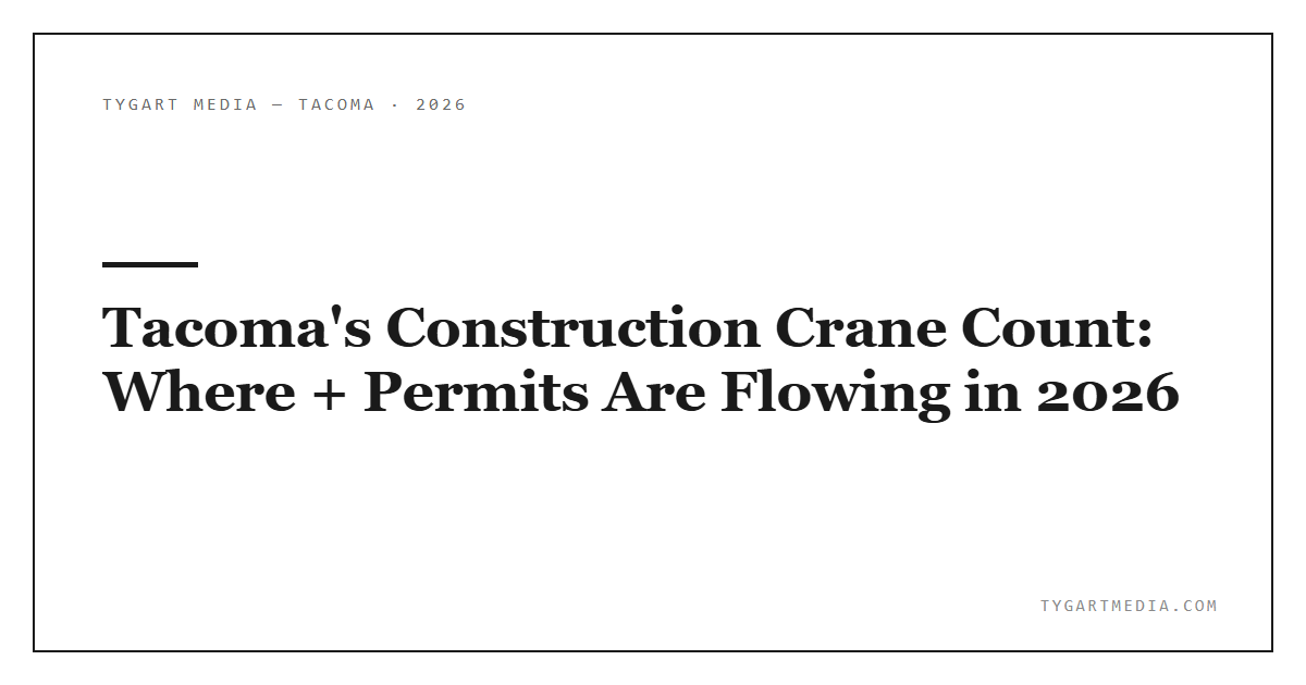
Port of Tacoma in 2026: Tariff Headwinds, Rail Resilience, and What the Numbers Actually Mean for Pierce County
If you run a business in Tacoma — whether you’re warehousing goods in Fife, managing a logistics operation near the tideflats, or importing materials through a freight broker — the Port of Tacoma is part of your cost structure whether you know it directly or not. In 2026, that port is navigating one of the more turbulent trade environments in recent memory, and the numbers tell a story worth understanding.
Container Volumes: Down, But Context Is Everything
Through April 2026, the Northwest Seaport Alliance (NWSA) — the joint venture managing marine cargo for both the Port of Tacoma and the Port of Seattle — handled 932,958 twenty-foot equivalent units (TEUs) year-to-date. That’s a decline of approximately 16% compared to the same stretch in 2025.
The headline number sounds rough. But the context is critical: 2025 was an anomaly. Shippers across the country front-loaded massive volumes of cargo in late 2024 and early 2025, racing to beat anticipated tariff hikes. Full imports surged 26.6% year-over-year at their peak. That artificial spike created a sky-high baseline that 2026 volumes are now measured against. You’re not comparing normal to normal — you’re comparing normal to a frenzy.
In January 2026, NWSA processed 228,166 TEUs, down 13.9% from January 2025. February came in at 207,725 TEUs, a 19.4% year-over-year decline. April held at 218,239 TEUs, off 21.4%. Each monthly report looks grim on paper until you account for what happened twelve months prior.
For Pierce County businesses tracking freight costs and lead times, the practical takeaway: capacity at the port is currently looser than it has been in years. That’s actually favorable for shippers — less congestion, more predictable dwell times, and terminals with room to operate efficiently.
Breakbulk Is the Story No One Is Covering
While container headlines have been dominated by volume declines, breakbulk cargo — the heavy, oversized, and project-type freight that doesn’t fit in standard boxes — is having a genuinely strong year at Tacoma.
NWSA handled 125,411 metric tons of breakbulk through April 2026, up 24% year-over-year, according to data from the NWSA newsroom. January alone saw breakbulk volumes jump 42.2%. The alliance attributes the growth to strong industrial demand, pointing to infrastructure investment, renewable energy projects, and manufacturing supply chains that rely on heavy-lift and project cargo.
This matters for Tacoma specifically because breakbulk operations are concentrated on Tacoma’s side of the gateway. Pierce County industrial businesses in sectors like construction materials, agricultural equipment, and manufacturing components are seeing this activity directly — and it’s a counter-narrative to the broader volume-decline story.
Rail: The BNSF Intermodal Play and What It Means for the Inland Network
The Port of Tacoma’s rail infrastructure is one of its most significant competitive advantages over other West Coast gateways, and 2026 is putting that advantage to the test.
The BNSF Tacoma South Intermodal Facility — opened in 2022 under a 16-year lease at Harbor Lot M — is a dedicated domestic intermodal hub built to handle more than 50,000 container lifts per year. BNSF operates the facility in partnership with NWSA, connecting Tacoma directly to Chicago via container-only rail service. Union Pacific also operates out of Tacoma, with Tacoma Rail’s Tidelands Division providing switching services to all four intermodal terminals within the port.
The tariff environment has reshaped how that rail network is being used. With trans-Pacific container volumes suppressed, intermodal traffic from Tacoma to inland markets has moderated. But both BNSF and Union Pacific are actively building capacity ahead of what they expect to be a significant cargo rebound. BNSF has added nearly 93 miles of double-track across its network and expanded production tracks and parking at West Coast intermodal facilities, according to reporting from the Journal of Commerce.
The expectation — widely shared among rail carriers, port operators, and freight analysts — is that the pause in U.S.-China tariffs will trigger a mid-2026 surge as delayed shipments finally move. Tacoma’s rail infrastructure positions it well to absorb that volume without the congestion that plagued Southern California ports during the 2021-2022 supply chain crunch.
Tacoma Rail: The Local Connector
Tacoma Rail, the city-owned short-line railroad, is the connective tissue between port terminals and the Class I railroads. Its Tidelands Division serves all four intermodal terminals and acts as the switch carrier for both BNSF and Union Pacific within the port. For businesses moving freight in or out of the tideflats, Tacoma Rail is often the last mile of the rail equation that doesn’t get enough attention.
Tariff Impacts on Tacoma Trade Routes
China is the port’s largest trading partner — by a wide margin. According to NWSA data, China accounts for roughly 40% of imports and 52% of exports flowing through the Seattle-Tacoma gateway. Asia overall represents 91% of total port trade. That concentration means U.S.-China tariff policy isn’t a background variable for this port — it’s the dominant driver of volume.
The tariff timeline has been disorienting for shippers. The 2024 frontloading surge, tariff implementation, the subsequent volume collapse, and now the pause-and-potential-rebound cycle have made it genuinely difficult to plan freight movements more than 90 days out. Local freight brokers and logistics providers working the Tacoma market have noted (community signal: Pacific Northwest logistics forums) that booking visibility has compressed significantly compared to pre-2023 norms.
The Choose Tacoma-Pierce County economic development office published analysis noting that tariff uncertainty has forced local businesses to hold higher inventory buffers and renegotiate supplier terms — real costs that show up in working capital requirements even when they don’t appear in port statistics.
Capital Investment: $77 Million in 2026 Alone
Despite the volume headwinds, infrastructure investment at the gateway continues. The Port of Tacoma’s share of NWSA capital investment is budgeted at $77.1 million for 2026, with approximately $228 million projected over the subsequent multi-year period, according to Port of Seattle budget documents. These represent terminal upgrades, equipment, and infrastructure improvements designed to keep Tacoma competitive as a top-six North American container port.
The port’s 2021-2026 Strategic Plan has prioritized modernization of on-dock rail, terminal efficiency, and environmental compliance — the latter increasingly a factor in shipper routing decisions as major cargo owners set emissions targets that include port selection criteria.
What Pierce County Businesses Should Be Watching
If you’re operating in Pierce County with any supply chain exposure to the port, here are the signals worth tracking in the second half of 2026.
The Rebound Timing
The pause in U.S.-China tariffs is expected to release a wave of pent-up shipments. BNSF and UP are both positioning for a July-August surge. If your business imports goods with Chinese origin, expect tighter capacity and potentially higher spot rates as that wave moves through West Coast ports. Tacoma’s position as a less-congested alternative to LA/Long Beach could work in your favor if you have flexibility in port of entry.
Breakbulk and Project Cargo Opportunity
The 24% year-over-year growth in breakbulk through April signals sustained industrial activity in the region. If your business is adjacent to construction, energy infrastructure, or heavy manufacturing — as a supplier, contractor, or service provider — the port’s breakbulk momentum is a reasonable leading indicator of sector health in Pierce County.
Rail as a Cost Lever
With the BNSF Tacoma South facility operating with capacity headroom right now, intermodal rail to Chicago and Midwest markets is competitively priced relative to over-the-road trucking. Pierce County shippers moving heavy goods east should be getting current quotes from intermodal providers — the current environment favors rail economics in ways that won’t persist once volume returns at scale.
The Bigger Picture: Tacoma’s Structural Position
The Port of Tacoma supports more than 42,000 jobs and generates approximately $2.8 billion in labor income in the region, according to port economic impact data. Combined with the Port of Seattle under the NWSA structure, the gateway supports an estimated 265,000 jobs and $55 billion in regional economic benefits. Average wages in port-related industries run around $95,000 annually — one of the highest-paying sectors in Pierce County.
That economic footprint doesn’t fluctuate dramatically with a bad quarter of container volumes. The port’s role as a Pacific Rim gateway — positioned closer to Asian ports via the Great Circle Route than East Coast alternatives — is structural, not cyclical. The tariff volatility of 2025-2026 is real and it’s affecting local businesses, but it’s playing out against a backdrop of long-term infrastructure investment and a rail network that few competing ports can match.
For the operators, logistics managers, and business owners working in Pierce County’s industrial corridors: the port is navigating a difficult patch, but it’s doing so from a position of structural strength. The numbers look worse than they are — and the second half of 2026 is likely to look meaningfully better than the first.
Frequently Asked Questions
How much have container volumes dropped at the Port of Tacoma in 2026?
Through April 2026, the Northwest Seaport Alliance handled 932,958 TEUs year-to-date, a decline of roughly 16% compared to the same period in 2025. The drop follows a period of aggressive frontloading in early 2025 when importers rushed cargo ahead of anticipated tariffs, creating a high baseline that 2026 volumes are now measured against.
What is the BNSF Tacoma South intermodal facility and why does it matter?
The BNSF Tacoma South facility, located at Harbor Lot M on the Port of Tacoma, is a dedicated domestic intermodal hub capable of handling more than 50,000 container lifts per year. Opened in 2022 under a 16-year lease, it provides direct container service to Chicago and connects Tacoma to the national rail network alongside Union Pacific. It’s a core piece of Tacoma’s strategy to compete as a West Coast logistics gateway.
How are tariffs affecting trade through the Port of Tacoma?
Tariffs have created significant volatility. China accounts for roughly 40% of imports and 52% of exports through NWSA, making the gateway highly sensitive to U.S.-China trade policy. The 2025 frontloading surge inflated year-over-year comparisons, and tariff implementation caused import volumes to fall sharply in early 2026. A pause in China tariffs is expected to trigger a cargo rebound in mid-2026, with both BNSF and Union Pacific actively preparing network capacity for the surge.
What is happening with breakbulk cargo at the Port of Tacoma?
Breakbulk is the standout bright spot in 2026. NWSA handled 125,411 metric tons of breakbulk cargo through April, up 24% year-over-year, driven by strong industrial demand. January alone saw breakbulk volumes jump 42.2%. This recovery reflects growing project cargo and heavy-lift activity — sectors less affected by consumer-goods tariff disruption.
How many jobs does the Port of Tacoma support in Pierce County?
Port of Tacoma operations support more than 42,000 direct jobs and generate approximately $2.8 billion in total labor income in the region. Combined with the Port of Seattle under the NWSA umbrella, the two ports support an estimated 265,000 jobs and $55 billion in regional economic benefits. The average annual wage for port-related positions is $95,000 — among the top-earning sectors in Pierce and King counties.
Related Reading
-
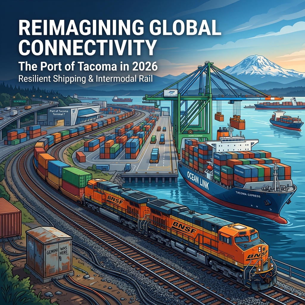
From Railway Palace to Tacoma Icon: The Unlikely Story of Stadium High School
On July 14, 1873, a crowd gathered at Yesler’s Mill in Seattle expecting to hear that their city had won the transcontinental railroad. Instead, they got a telegram that read: “We have located the terminus on Commencement Bay.” Tacoma — scarcely a village at the time — had been chosen over Seattle as the western end of the Northern Pacific Railway, and nothing in Pierce County would ever be the same.
That single decision set off a chain of events that would eventually produce one of the most architecturally striking high schools in America: the chateau-crowned building at 111 North E Street that Tacoma residents call Stadium High School, and that the rest of the world knows as the backdrop to a certain 1999 Shakespeare adaptation filmed right on the bluff above Commencement Bay.
But the story between the 1873 telegram and the 1999 film crew is one of ambition, financial ruin, fire, citizen activism, and the kind of resilient improvisation that defines Tacoma at its best.
The Railroad Bets on Tacoma
The Northern Pacific’s engineers chose Commencement Bay for practical, not sentimental reasons. The Prairie Line — the flat, treeless corridor connecting Tacoma to the interior — offered the path of least resistance to tidewater. Seattle had lobbied hard, reportedly offering the railroad 7,500 town lots, 3,000 acres, $50,000 in cash, and $200,000 in bonds. The Northern Pacific took Tacoma’s waterfront instead.
The choice was transformative. Tacoma’s population stood at roughly 1,100 in 1880. By 1889 — the year Washington achieved statehood — it had exploded to 36,000, according to HistoryLink.org. The city platted streets, attracted sawmills and smelters, and began to fancy itself the commercial capital of the Pacific Northwest. The Tacoma Land Company, the railroad’s real estate arm, controlled vast swaths of the city and moved aggressively to shape its identity.
Part of that identity was supposed to be a world-class hotel.
The Hotel That Never Opened
In 1891, the Tacoma Land Company commissioned Philadelphia architects Hewitt and Hewitt to design a palatial tourist hotel on a bluff north of downtown. The site commanded sweeping views of Commencement Bay and the Olympic Mountains beyond. The architects responded with a design drawn directly from the châteaux of France’s Loire Valley: steep mansard rooflines, copper-topped turrets rising from every corner, ornate dormers, and facades built from Roman brick — a distinctive elongated brick style that gave the building its warm, reddish-gold character.
Construction began with the momentum of a city convinced of its own destiny. Then the Panic of 1893 hit.
The financial crisis that swept the country in 1893 devastated the Northern Pacific. The company went into receivership. The half-finished hotel on the bluff was quietly abandoned, its turrets and rooflines standing without windows or interior floors, a monument to interrupted ambition. For a time it served as a lumber and shingle warehouse. Then, on October 11, 1898, fire tore through the building, gutting it completely and leaving only the exterior walls standing.
The Northern Pacific began dismantling the shell, reportedly removing some 40,000 of the distinctive Roman bricks before two Tacoma citizens intervened to halt the demolition. Their argument: the walls were salvageable, the bones were sound, and the city desperately needed a high school.
Citizens Save the Building
The Tacoma School District purchased the fire-gutted structure on February 19, 1904, and hired local architect Frederick Heath to complete the reconstruction. Heath’s task was unusual — he was not designing a new building so much as finishing and converting one that had been started by someone else’s vision, interrupted by economic disaster, and partially destroyed by fire.
Heath preserved the Châteauesque exterior that the Hewitt brothers had designed while reworking the interior entirely for educational use. The building that opened on September 10, 1906, as Tacoma High School was recognizably the same chateau the railroad had started — multiple turrets, mansard lines, the copper detailing — but now filled with classrooms, corridors, and students rather than hotel suites and dining rooms.
In 1913, when Lincoln High School opened as the district’s second secondary school, Tacoma High School was renamed. The name everyone now knows — Stadium High School — came from the natural feature directly to the south: a ravine called Old Woman’s Gulch that Frederick Heath had also been commissioned to transform into an outdoor athletic venue.
The Stadium Bowl: Engineering a Natural Amphitheater
Old Woman’s Gulch cut deep into the Stadium District, its floor originally below sea level and subject to tidal flooding. Between 1909 and 1910, construction crews using steam shovels and hydraulic sluicing moved more than 180,000 cubic yards of earth to level the ravine floor and shape its walls into terraced seating. Wooden molds were poured to cast 31 rows of concrete seating for 11,000 spectators, with the open north end framing an unobstructed view of Commencement Bay and Puget Sound.
The resulting Stadium Bowl — dedicated on July 10, 1910, at a cost of $135,000 — was one of the largest outdoor athletic venues in the Pacific Northwest. The school and the stadium became inseparable in the public mind, each reinforcing the other’s architectural drama. The chateau on the bluff looked down at the bowl carved from the earth below; together they defined a neighborhood.
The Stadium District Takes Shape
The Stadium-Seminary Historic District that grew around the school between 1888 and 1930 is itself a remarkable piece of Tacoma history. The neighborhood — roughly 400 buildings across 50 blocks on the bluff northwest of downtown — developed as the Tacoma Land Company released residential parcels and middle-class families built substantial two- and three-story homes in Queen Anne, Colonial Revival, and Craftsman styles.
The neighborhood’s layout reflected, however loosely, the ideas of the City Beautiful movement. Frederick Law Olmsted had been commissioned in 1873 to prepare a master plan for New Tacoma; though his specific proposals were never implemented, the design sensibility he represented — broad streets, topographic sensitivity, attention to views — influenced how the Stadium District ultimately developed.
Today the district is listed on both the Washington State and National Registers of Historic Places. The City of Tacoma’s Historic Preservation Office maintains design review authority over development within it. The near-continuous architectural character — Victorian-era homes beside Craftsman bungalows, largely untouched by mid-century demolition — is rare for a city of Tacoma’s size.
From Preservation to Pop Culture
In 2005 and 2006, Stadium High School underwent a major seismic upgrade, historical restoration, and expansion designed to preserve the building for the next century of students. The renovation carefully maintained the exterior’s historic character — the turrets, the rooflines, the Roman brick — while modernizing the interior for contemporary educational use.
By then, the school had already achieved a different kind of fame. When location scouts for the 1999 film 10 Things I Hate About You — a modern retelling of Shakespeare’s The Taming of the Shrew — saw photographs of Stadium High School, they scrapped plans to film in Los Angeles and moved the entire production to Tacoma. The film’s opening sequence, with Heath Ledger and Julia Stiles navigating the chateau’s corridors and exterior courtyard, introduced the building to a global audience who had no idea they were looking at a failed railway hotel from 1891.
According to The Seattle Times, alums of Stadium High describe the film as having “put the school on the map” nationally — which is saying something for a building already on three historic registers.
What the Building Means for Tacoma
There’s a temptation to read Stadium High School purely as a happy accident — abandoned railroad ambition recycled into public good. But the building’s survival required active choices at several points: the citizens who halted demolition in 1898, the school board that voted to purchase the shell, the architect who honored the original design in his reconstruction, and the community that successfully argued for its historic designation decades later.
The Washington State Historical Society documents Tacoma’s railroad era extensively, and the Northern Pacific’s choice of Commencement Bay as its terminus runs as a through-line in nearly every major story about the city’s early growth — from the original platting of downtown to the industrial development of the tideflats to the residential neighborhoods that climbed the surrounding bluffs.
Stadium High School is the most visible physical artifact of that era. It is the building that the Northern Pacific built, that the Panic of 1893 stopped, that fire gutted, that citizens saved, and that Tacoma finished. It has been a school for 120 years. It will likely be one for a good while longer.
For anyone who wants to understand how Tacoma became Tacoma, the view from the Stadium District bluff — chateau to the left, the bowl below, the bay beyond — is about as clear an explanation as the city offers.
Frequently Asked Questions About Stadium High School
Why was Stadium High School originally built as a hotel?
The Northern Pacific Railway’s Tacoma Land Company began construction of a luxury chateau-style hotel in 1891 to anchor its investment in Tacoma, the railroad’s chosen western terminus since 1873. The hotel was designed to attract wealthy travelers and signal Tacoma’s status as the premier city on Puget Sound. The Panic of 1893 halted construction before the building ever opened.
What architectural style is Stadium High School?
Stadium High School is built in the Châteauesque style, drawing from French Renaissance châteaux of the Loire Valley. Designed by Philadelphia architects Hewitt and Hewitt, the building features multiple copper-topped turrets, steep mansard rooflines, decorative dormers, and facades built from Roman brick. It is listed on the Tacoma, Washington State, and National Registers of Historic Places.
When did Stadium High School open and why did the name change?
The school opened September 10, 1906, as Tacoma High School after the district purchased the fire-gutted hotel shell in 1904 and commissioned architect Frederick Heath to complete the reconstruction. The name changed to Stadium High School in 1913 when Lincoln High School opened as the district’s second high school, requiring a more specific name tied to the adjacent Stadium Bowl.
What movie was filmed at Stadium High School?
The 1999 film 10 Things I Hate About You, a modern adaptation of Shakespeare’s The Taming of the Shrew, was filmed extensively at Stadium High School. Location scouts originally planned to film in Los Angeles but moved the entire production to Tacoma after seeing photographs of the school’s dramatic exterior overlooking Commencement Bay.
Is Stadium High School a historic landmark?
Yes. Stadium High School is listed on the Tacoma Register of Historic Places, the Washington State Register of Historic Places, and the National Register of Historic Places. The surrounding Stadium-Seminary Historic District — nearly 400 buildings across 50 blocks — is also listed on both registers. A major seismic upgrade and historical restoration was completed in 2005–2006.
Related Reading
-

Pierce County Commercial Real Estate: Q1 2026 Deal Flow
The Numbers Behind Pierce County’s Most Active Commercial Property Quarter in Recent Memory
If you’ve been watching cranes move through the Fife tideflats or noticed industrial “For Lease” signs disappear faster than they go up, you’re reading the market correctly. Pierce County’s commercial real estate market turned in a notable Q1 2026: 37 industrial leases signed, 14 building sales closed, 1.27 million square feet of space absorbed on the leasing side alone, and a Canadian logistics company setting up shop right next to the Port of Tacoma. The story isn’t simple, though. Vacancy is rising, rents are softening in pockets, and the port is handling 17% less cargo volume than a year ago. Understanding what’s driving deal flow here requires pulling apart the data layer by layer.
Industrial: The Engine Is Running, But Fuel Costs Are Up
Pierce County’s industrial inventory hit 103.7 million square feet at the close of Q1 2026, following the delivery of three new buildings totaling 1.24 million square feet. That addition explains why the vacancy rate ticked up to 12.16% — a 54-basis-point increase over year-end 2025’s 11.71% — even though absorption for the quarter was positive at 625,284 SF. New supply is outpacing demand at the moment, but not by a wide margin, and the leasing activity underneath those numbers is robust.
The quarter’s 37 lease signings averaged 38,767 SF per deal, with a median of 21,382 SF — a healthy mix of mid-size operators alongside larger logistics users. For local business owners and investors, that median figure is the one to watch. Mid-size industrial users — contractors, distributors, light manufacturers — are active in this market, and spaces between 15,000 and 40,000 SF are moving. Source: Kidder Mathews Q1 2026 Seattle Industrial Market Report.
Stryder Logistics Plants a Flag at Port Commerce Center
The most notable individual lease to emerge from the Tacoma market this spring: Stryder Logistics, a Canadian-based third-party logistics (3PL) provider, signed a 103,000-square-foot lease at Port Commerce Center, positioned adjacent to the Port of Tacoma. The deal — reported by The Registry Pacific Northwest on April 14, 2026 — represents a cross-border operator expanding its Pacific Northwest warehouse network to capture capacity near one of the West Coast’s primary container ports.
It’s a signal that even as cargo volumes at the Northwest Seaport Alliance track 16.6% below prior-year levels through February, logistics operators are still betting on Tacoma’s port infrastructure for medium-to-long-term positioning. That bet makes strategic sense: the Port of Tacoma’s deep-water berths, direct rail connectivity to Union Pacific and BNSF, and proximity to I-5 and SR-167 make the tideflats submarket a durable anchor for distribution networks — even in quarters where TEU counts disappoint.
Bridge Point Tacoma 2MM: The Mega-Project Reshaping the Fife Corridor
The biggest single development shaping Pierce County’s industrial supply picture is Bridge Industrial’s Bridge Point Tacoma 2MM — a four-building, 2.5-million-square-foot campus located roughly five miles from the Port of Tacoma with direct I-5 access. As of Q1 2026, the first two buildings are delivered and available: Building A at 517,042 SF and Building B at 957,726 SF. Buildings C (662,044 SF) and D (332,295 SF) are under construction.
The project is 64.8% preleased — a meaningful number given its scale. Bridge’s ability to line up tenants before steel goes up on the final two buildings signals that large-format end-users are still signing long-term commitments in this market despite headwinds from trade policy uncertainty and elevated fuel costs. The broader Pierce County construction pipeline includes 23 proposed projects that would add 4.2 million SF — though Kidder Mathews notes that many depend on pre-leasing and may be delayed.
Rents: Stable Face Rates, But Watch the Concessions
Industrial asking rents in Pierce County are holding at approximately $0.85 per square foot per month NNN, up fractionally from $0.84 at year-end 2025. Shell rates range from $0.90 to $1.30 PSF NNN, with office add-ons at $1.00 to $1.70 PSF. Those numbers look stable on paper, but the embedded market note from Kidder Mathews is worth flagging: landlords are “striving to keep face rates up with more rent abatement.” In practical terms, the effective rent — what a tenant actually pays once free rent and tenant improvement allowances are factored in — is softening even as the published rate holds. Tenants with credit and scale have negotiating leverage right now.
Sales Activity: $74 Million Changes Hands in Q1
On the investment side, 14 industrial building sales closed in Q1 2026 across Pierce County, totaling $74.33 million. That volume covered 572,523 SF of buildings on 41.5 acres of land, averaging $164 per square foot. For context, the Southend submarket (Kent, Auburn, Renton) saw 10 sales total $91.37M at an average of $242 PSF in the same quarter — which illustrates the pricing differential between Pierce County and closer-in King County submarkets. Pierce County is a value market for investors, and for owner-users acquiring for long-term occupancy, that per-square-foot basis matters.
Regionally, 85 industrial buildings traded hands in Q1 2026 for $368.4 million total, with an average capitalization rate of 6.6% and average pricing of $208 PSF. That cap rate — up from the compressed levels of 2021–2022 — reflects a repricing as interest rates have remained elevated. The Federal Reserve held its target rate steady at 3.50%–3.75% through Q1. Life company lending spreads are running 135 to 220 basis points over the 10-year Treasury, translating to all-in rates of roughly 5.56% to 6.51%. Cap rates and financing costs are closer to equilibrium now, which is one reason transaction volume is recovering even if pricing hasn’t fully reset.
Land is also moving. A 0.8-acre Pierce County site sold at $32 PSF during the quarter, and two larger sites — each planned for approximately 100,000 SF of industrial development — are expected to close in Q2 2026.
Multifamily: Private Capital Steps Into the Institutional Void
The investment thesis driving multifamily deal flow in Washington right now is a rotation of capital. A Berkadia Q1 2026 market analysis covered by The Registry found that mid-market and private capital investors are absorbing deal flow that institutional buyers have stepped back from. Pierce County — Tacoma, Puyallup, Federal Way, South Hill, Lakewood — is one of the state’s hotter submarkets in this cycle precisely because institutional pullback has created entry points that private operators can exploit.
The logic is straightforward: the county’s workforce housing demand is durable, rents are materially below King County, and the price-per-door basis on acquisitions has moderated from 2021 peaks. For a private operator with patient capital and local operating knowledge, that’s a workable spread. Community signal from local property manager networks (community source) echoes this: mid-size apartment transactions — 20 to 80 units — in Tacoma, Puyallup, and Federal Way are reportedly moving faster than in late 2025, with some properties seeing multiple offers again after a quiet stretch. That pattern rhymes with what Berkadia’s institutional analysis shows.
Office: The County’s Own Portfolio Move
The most-discussed office transaction in recent Tacoma history was Pierce County government’s acquisition of the 1501 Market Street office building — a deal that closed for just under $27.3 million, with seller Regence BlueShield divesting a property it had owned for decades, according to the Seattle Daily Journal of Commerce. Pierce County added the building and associated parking lot to its real estate portfolio for public use. That transaction set the benchmark for downtown Tacoma office pricing and removed a significant asset from private-market availability.
The broader office market in Tacoma remains challenged. Hybrid work has structurally reduced space requirements, and Pierce County’s office inventory is thinner and less amenitized than Seattle or Bellevue, making it more dependent on public-sector and healthcare tenants. Healthcare users are among the few categories actively expanding their physical footprints — a trend visible at a regional level in deals like Providence’s 259,570 SF commitment at Renton’s Longacres campus, co-brokered by The Andover Company in April 2026.
What the Macro Headwinds Actually Mean for Pierce County
The Kidder Mathews Q1 2026 report opens with a candid assessment: global trade policy uncertainty, shipping disruptions, elevated fuel costs, and increased insurance expenses are all placing “continued pressure on global supply chains.” Northwest Seaport Alliance cargo volumes came in at 435,890 TEUs for January and February 2026 — a 16.6% decline from the same period in 2025. Regional unleaded gasoline averaged $5.36 per gallon as of April 1, 2026, up 23.3% from January. These are real operating cost pressures for logistics and distribution businesses in Tacoma’s industrial base.
What counterbalances this: Pierce County’s long-run infrastructure advantages aren’t going anywhere. The Port of Tacoma, I-5 and SR-167 interchanges, rail access, and the county’s growing workforce population all support sustained demand for commercial space. The question isn’t whether Pierce County is a real market — it clearly is — but what the right cost basis and lease structure looks like in a period of compressed margins and elevated uncertainty.
What to Watch in Q2 and Beyond
Several data points will clarify the trajectory over the next two quarters. First, the two large industrial land sites expected to close in Q2 — each planned for 100,000 SF of new industrial — will gauge developer confidence. Second, the pre-leasing pace at Bridge Point Tacoma 2MM’s remaining two buildings will indicate whether large-format logistics demand is still absorbing speculative product. Third, the port’s May and June cargo volume numbers will reveal whether the early 2026 decline is a transient tariff-driven dip or something more sustained.
For local investors and operators, the through-line in this quarter’s data is that Pierce County remains a transaction market — money is moving, leases are being signed, buildings are being built. The pace is measured rather than frantic, pricing has come off its peak, and tenants have more leverage than two years ago. That’s a more nuanced market than the pandemic-era frenzy, but it’s a functional one — and for operators with local knowledge and a long view, it’s a market worth being in.
Frequently Asked Questions: Pierce County Commercial Real Estate 2026
How much industrial space was leased in Pierce County in Q1 2026?
Pierce County recorded 37 industrial lease signings in Q1 2026, totaling 1.27 million square feet. The average deal size was 38,767 SF and the median was 21,382 SF, according to Kidder Mathews market data.
What is the industrial vacancy rate in Pierce County in 2026?
Pierce County industrial vacancy rose to 12.16% in Q1 2026, up 54 basis points from 11.71% at year-end 2025. The increase reflects the delivery of 1.24 million square feet of new inventory — not a demand collapse, as absorption was positive at 625,284 SF for the quarter.
What is the average industrial lease rate in Tacoma right now?
Asking rents for industrial space in Pierce County are approximately $0.85 per square foot per month NNN as of Q1 2026. Shell rates range from $0.90 to $1.30 PSF NNN. Landlords are maintaining face rates while offering rent abatement and TI concessions to attract tenants.
What is Bridge Point Tacoma 2MM and how big is it?
Bridge Point Tacoma 2MM is a four-building, 2.5-million-square-foot industrial campus developed by Bridge Industrial near I-5, approximately five miles from the Port of Tacoma. As of Q1 2026, Buildings A (517,042 SF) and B (957,726 SF) are complete and available; Buildings C (662,044 SF) and D (332,295 SF) are under construction. The project is 64.8% preleased.
Why are private capital investors targeting Pierce County multifamily in 2026?
According to a Berkadia Q1 2026 market report, mid-market and private capital investors are filling the void left by retreating institutional buyers. Pierce County offers lower entry prices than King County, durable workforce housing demand, and improving amenity infrastructure across Tacoma, Puyallup, Federal Way, and South Hill.
-
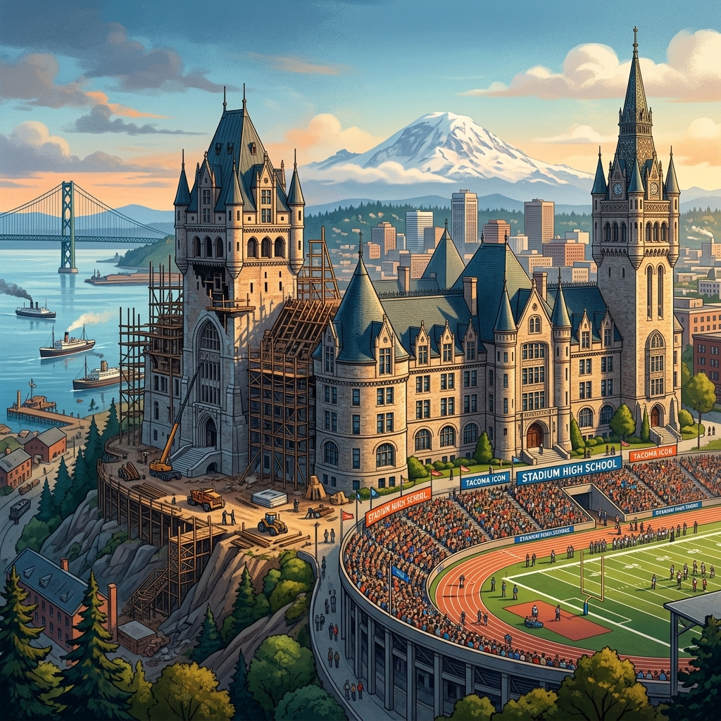
Tacoma Sister Cities: How Diplomacy Drives Global Trade
When a delegation from South Africa’s Garden Route District Municipality touched down in Tacoma last April, they weren’t here for tourism. They were here to talk trade — specifically, how two port-anchored communities on opposite sides of the globe can build supply chains, share skills, and move goods between them.
The April 23–28, 2026 exchange — part of a formal partnership between Tacoma Sister Cities International and the Garden Route District — is one of the clearest recent signals of how seriously Tacoma is beginning to use its 15 sister city relationships as genuine economic infrastructure rather than ceremonial diplomacy. And for Pierce County businesses paying attention, the implications are worth understanding.
From Handshakes to Deal Flow: What the Garden Route Visit Actually Covered
The Garden Route District Municipality spans South Africa’s Southern Cape, coordinating seven local municipalities and representing more than 630,000 residents. Its relationship with Tacoma traces back 28 years to a connection with the city of George — but in a move that quietly made international trade news, the Tacoma City Council formally elevated that relationship to a full district-wide partnership, substantially expanding the scope of what’s possible.
The April delegation got specific. According to the Garden Route District Municipality’s official release, discussions centered on three concrete areas:
The global ostrich industry. South Africa’s Garden Route — particularly the Klein Karoo region — is one of the world’s dominant ostrich product hubs, producing leather, feathers, and meat that move through international luxury and food supply chains. The delegation explored how the Port of Tacoma’s freight infrastructure could facilitate new export pathways for these high-value goods into Pacific Rim markets.
Port logistics and trade facilitation. Both communities are defined by their port identities. The delegation examined how improved coordination between their respective port operations could reduce friction in bilateral trade flows — a practical, operator-level conversation, not a ceremonial one.
Skills transfer and educational exchange. South Cape College and Africa Skills Village entered discussions about formal academic and artisanal exchange programs with Tacoma institutions, creating the kind of human-capital connections that tend to precede sustained economic relationships.
Community reporting from South Africa’s The Gremlin described the visit’s tone as focused on “collective approaches to boost economic growth, skills transfer and sustainable tourism” — language that sounds like an investment thesis, not a cultural exchange brochure.
WTC Tacoma: The Infrastructure Behind the Relationships
None of this happens without an institutional engine. The World Trade Center Tacoma has quietly built itself into the largest membership-based trade organization in the Pacific Northwest, and by some measures the fastest-growing World Trade Center in North America over the past several years.
WTC Tacoma’s core function is converting diplomatic relationships into actual commerce. It provides trade research, business matchmaking between local firms and international partners, import/export consulting, and manages both inbound and outbound trade missions. Critically, it also runs Tacoma’s foreign direct investment attraction programs — the effort to bring capital from abroad into Pierce County projects.
The most visible example of that FDI work is the Tacoma-Fuzhou Trade Initiative, which grew out of Tacoma’s sister city relationship with Fuzhou, China — a city Xi Jinping led as Party Secretary when the original bond was formed in 1994. In 2019, Tacoma and Fuzhou simultaneously opened trade offices in each other’s cities, with the City and Port of Tacoma contributing $100,000 to fund the Fuzhou office. China remains the single largest trading partner of the Port of Tacoma.
The 2026 WTC Globe Awards — scheduled for September 24 at Port of Tacoma Headquarters — will mark another year of recognizing the businesses and individuals driving this work. It’s worth attending if you want to understand who’s actually moving the needle on international trade in Pierce County.
The Port Numbers That Explain the Strategy
Tacoma’s sister city diplomacy doesn’t happen in a vacuum. It’s backed by real freight infrastructure that gives international partners a reason to engage seriously.
The Northwest Seaport Alliance — which combines the ports of Tacoma and Seattle — handled nearly $76 billion in waterborne trade with 176 trading partners globally in 2024. Japan, South Korea, and Taiwan all rank among the top five trading partners. The port complex handles approximately 1.8 to 2 million TEUs of container throughput annually.
In 2026, the story is mixed but mostly positive: NWSA breakbulk cargo volumes are up 24 percent year-over-year through April, driven by project cargo and heavy lift freight. Container volumes dipped in April amid broader trans-Pacific trade disruptions, but the port’s long-term Pacific Rim positioning remains intact.
That infrastructure is the reason why a South African delegation talks seriously about using Tacoma as a Pacific access point. The port makes the pitch credible.
The APCC Expansion and the Cultural Backbone of Trade
Sustained trade relationships require cultural infrastructure, not just port capacity. In Tacoma, that infrastructure runs through the Asia Pacific Cultural Center, which has been working toward a significant expansion that would add a demonstration kitchen, cultural classrooms, an Asian Pacific Islander library, office and conference space, and a large exhibition hall.
Federal funding has advanced through the House to support that expansion — Congressman Derek Kilmer’s office confirmed the appropriations movement — giving the APCC the resources to serve as a genuine anchor for Tacoma’s AAPI business community and its international connections.
Tacoma is one of the most racially diverse cities in Washington State, with nearly 40 percent of residents identifying as Latino, African American, Asian and Pacific Islander, Multiracial, or Native American. That demographic reality is also an economic one: the region’s API-owned small businesses, workforce bilingualism, and cultural networks form a substrate that makes international business development more viable here than in many comparable mid-sized cities.
What This Means for Pierce County Operators
Here’s the practical read for local business owners and operators: Tacoma’s international infrastructure is more developed than most people realize, and it’s increasingly organized around generating actual deal flow rather than ribbon-cutting ceremonies.
The sister city program — through Tacoma Sister Cities International — can connect businesses to counterpart organizations in 15 cities across multiple continents. WTC Tacoma’s membership provides access to trade consulting and matchmaking that most small businesses couldn’t afford to replicate independently. The Economic Development Board at choosetacomapierce.org maintains a dedicated international business support function.
The April 2026 Garden Route visit is a useful model to study. It wasn’t an abstract diplomatic exchange — it was a structured conversation about specific products (ostrich goods), specific logistics (port connections), and specific human capital pathways (skills exchange programs). That’s what mature sister city relationships look like when they’re working. Pierce County’s international trade apparatus, at its best, operates the same way.
The WTC Globe Awards in September will be the next public moment to see who’s driving this ecosystem. Between now and then, the Garden Route partnership will either produce tangible agreements or fade into the archives of well-intentioned visits. Based on how deliberately both sides have framed this one, the early signals favor the former.
Frequently Asked Questions
How many sister cities does Tacoma have?
Tacoma currently maintains 15 official sister city relationships spanning Asia, Europe, Africa, Latin America, and the Pacific. Key partners include Fuzhou (China), Kitakyushu (Japan), Cheboksary (Russia), Cienfuegos (Cuba), and — most recently elevated — the Garden Route District Municipality in South Africa.
What does the World Trade Center Tacoma do?
The World Trade Center Tacoma (WTC Tacoma) is the largest membership-based trade organization in the Pacific Northwest. It provides trade research, business matchmaking, export/import consulting, and manages inbound and outbound trade missions. It also coordinates Tacoma’s foreign direct investment attraction programs, including the Tacoma-Fuzhou Trade Initiative with a sister office in Fuzhou, China.
What was the purpose of the April 2026 Garden Route delegation to Tacoma?
The Garden Route District Municipality delegation visited Tacoma April 23–28, 2026 to explore trade opportunities in the ostrich products industry, establish port logistics connections, and build skills exchange programs with local educational institutions. The visit built on the Tacoma City Council’s formal elevation of the city’s 28-year relationship with George, South Africa to a full district-wide partnership with the Garden Route municipality.
Why is the Port of Tacoma important for Pacific Rim trade?
The Port of Tacoma is one of the leading deep-water ports on the U.S. West Coast, handling over $25 billion in commerce annually as part of the Northwest Seaport Alliance. China, Japan, South Korea, and Taiwan rank among its top five trading partners. In 2026, NWSA breakbulk volumes are up 24 percent year-over-year, underscoring Tacoma’s growing role as a Pacific gateway for project cargo and specialized freight.
How can Pierce County businesses get involved in international trade through Tacoma?
Local businesses can engage through WTC Tacoma (wtcta.org), which offers trade consulting, matchmaking, and mission programming. The Economic Development Board for Tacoma-Pierce County (choosetacomapierce.org) also connects businesses to export resources and international investor networks. The annual WTC Globe Awards — scheduled for September 24, 2026 at Port of Tacoma HQ — is a key networking event for anyone engaged in the region’s international trade ecosystem.
-
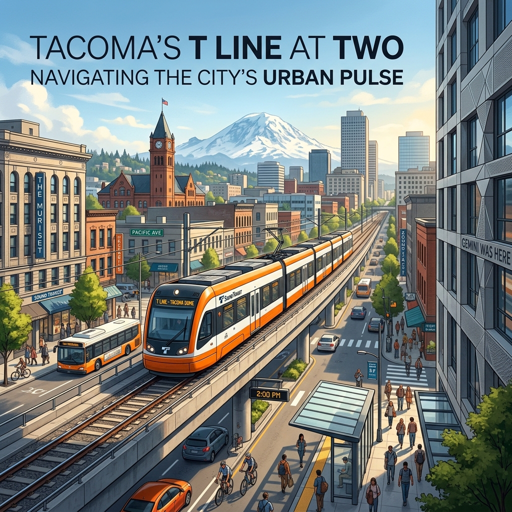
Tacoma T Line Ridership Soars Amid TCC Extension Delays
Tacoma’s T Line at Two: Ridership Soars, But the Road to TCC Runs Through 2043
Two and a half years after the Hilltop Tacoma Link Extension reshaped how Pierce County moves, the numbers are in — and they’re largely good news for local transit advocates. The T Line is beating Sound Transit’s own ridership projections, running at nearly perfect on-time performance, and drawing new riders who never had a reason to take the streetcar before. But the road ahead is complicated: the next major extension won’t arrive until the late 2030s at the earliest, Sound Transit is wrestling with a .5 billion funding gap across its ST3 program, and the promise of 10-minute service intervals remains unfulfilled.
Here’s where Tacoma’s light rail network stands in 2026, what’s working, what isn’t, and what Pierce County residents can realistically expect over the next decade.
Ridership Numbers: Better Than Billed
When Sound Transit opened the Hilltop extension in September 2023, the agency projected the expanded T Line would carry between 2,000 and 4,000 daily passengers by 2026. That projection’s upper bound is now the floor.
According to Sound Transit’s publicly available ridership data, the T Line averaged 3,618 daily boardings per month in 2024 and climbed to 4,079 average daily boardings in 2025. Monthly averages increased nearly 170% between 2023 and 2025 — a recovery story that Sound Transit acting service delivery director Benjamin Marx presented to the agency’s Rider Experience and Operations Committee in September 2025, per Mass Transit Magazine.
Pandemic-era ridership had cratered the T Line to just 1,282 average daily boardings between 2020 and 2023. The line carried 3,658 daily boardings on average in 2019 — a benchmark it has now surpassed. The system also ran 99.5% of all scheduled trips through 2025 and received no more than six rider complaints in any single month since May 2024, according to Sound Transit spokesman David Jackson.
“I think we’re pretty pleased with how ridership is going,” Jackson said. “Light rail, in general, has recovered pretty well from pandemic declines both in Seattle and Tacoma.”
Which Stations Are Pulling Their Weight?
The Tacoma Dome Station remains the T Line’s workhorse — clocking roughly 312,000 boardings since 2024 and serving as the critical hub connecting riders to Sounder commuter rail, Sound Transit Express buses to Seattle, and the broader Pierce Transit network. End-of-line terminus stations almost always top ridership charts, and Tacoma Dome is no exception.
Among the new Hilltop Extension stations, Stadium District leads with more than 158,000 boardings through mid-2025 — driven largely by Stadium High School and proximity to the business district that suffered financially during construction. The St. Joseph Station (the western terminus) has accumulated more than 151,000 boardings, while the Hilltop District Station has seen nearly 122,000. The seven Hilltop Extension stations combined account for roughly 42% of all T Line boardings since 2024.
Tacoma City Council member Kristina Walker, who also sits on the Sound Transit board, put it plainly: “No matter where they come into the system, that’s a person that’s not in a car or in our streets.”
The Fare Factor and What It Funds
The T Line was completely free to ride from 2003 through September 2023. That era ended with the Hilltop Extension. Today, fares are structured on the ORCA system: .00 for adults, .00 for ORCA LIFT cardholders, .00 for seniors and disabled riders, and free for youth.
In 2024, fare revenues on the T Line totaled ,000 — a real number, but a modest fraction of the line’s roughly million annual operating costs. Through mid-2025, fares had brought in ,000. Sound Transit is not running the T Line on fare-box recovery; this is publicly subsidized service. ORCA LIFT exists specifically to ensure cost isn’t a barrier for low-income Pierce County residents.
The 10-Minute Promise: Still Pending
One commitment the Hilltop Extension made but hasn’t delivered: 10-minute train intervals. The T Line currently runs every 12 minutes during peak hours — a gap Sound Transit has attributed to right-of-way constraints and operator break scheduling.
Sound Transit’s partial remedy: extended operating hours. The T Line now runs a 17-hour weekday service window, up from a 14-hour span. “This change in service yields significantly more weekday service on the T Line,” Jackson said. The agency maintains that future infrastructure improvements will eventually support 10-minute headways — but no firm timeline exists.
Community feedback (a consistent signal in local forums and Pierce County transit discussions) reflects appreciation for the line’s reliability and expanded reach, while noting that frequency hasn’t yet matched the extension’s ambition.
What’s Next: The TCC Extension and ST3 Funding Reality
The next chapter of the T Line was supposed to be the TCC T Line Extension — six new stations stretching from the current St. Joseph terminus westward through the Hilltop corridor and out to Tacoma Community College. The extension would grow the T Line from 4.2 miles and 12 stations to 8.4 miles and 18 stations, connecting a campus of roughly 13,000 students to the regional transit grid.
Sound Transit’s official target is a 2039 delivery date, funded under the voter-approved ST3 package. But that timeline is under real pressure.
In March 2026, Sound Transit’s board convened to address a .5 billion funding shortfall across its entire ST3 program — driven by construction cost inflation, lower-than-expected tax revenues, and pandemic economic effects. The agency’s “Enterprise Initiative” is a comprehensive effort to deliver maximum ST3 benefits within available resources, with the board evaluating approaches to the updated ST3 System Plan through summer 2026.
For Pierce County, the TCC T Line Extension and the Tacoma Dome Link Extension (TDLE) have remained on track through the restructuring process. But the TCC extension carries a reported million project affordability gap, and Jackson confirmed the board has begun “another reassessment process” due to “continuing financial headwinds.” Some independent analyses place realistic completion as late as 2043.
The Tacoma Dome Link Extension: A Bigger Picture
Separate from the T Line but critical to Pierce County’s transit future, the Tacoma Dome Link Extension would add approximately 8.5 miles of elevated light rail between Federal Way and Tacoma, extending the 1 Line south. Sound Transit’s board selected a preferred alignment alternative in June 2025 and is now advancing design work and fieldwork in preparation for the Final Environmental Impact Statement.
When TDLE opens — likely in the 2030s — Tacoma Dome Station will transform into a full light rail interchange, connecting the 1 Line to the T Line and dramatically increasing transit catchment for both systems. That convergence is arguably the most consequential long-term transit development on Pierce County’s horizon.
Pierce Transit’s Parallel Moves
The T Line doesn’t operate in isolation. Pierce Transit implemented a notable service change in March 2026 that directly affects T Line connectivity. The agency extended its Stream Community Line — a bus rapid transit-style route serving the Highway 7 corridor between Tacoma and Spanaway — all the way to Commerce Street Station in downtown Tacoma. New stops include Pacific Avenue at 14th Street and 19th Street. The extension runs during weekday morning and evening peak hours.
Pierce Transit also added frequency on Routes 1 and 3, two of its highest-ridership Tacoma corridors, with 8–10 new daily trips added to each route as part of its Bus System Recovery Plan.
Transit-Oriented Development: Following the Rails
Light rail extensions tend to reshape neighborhoods, and the Hilltop Extension is no exception. The Stadium District and Hilltop District station areas have seen increased multifamily residential interest since 2023. The Hilltop neighborhood — historically underserved by transit despite being geographically central — is now accessible by rail for the first time, connecting Hilltop residents to employment centers at Tacoma Dome and the downtown core.
Tacoma Council member Jamika Scott, who represents Hilltop, flagged the need to protect businesses during any future construction phases. Stadium District businesses suffered significant foot-traffic losses during the Hilltop Extension’s five-year build. That lesson will need to shape how the TCC extension is managed when it eventually breaks ground.
The Bottom Line for Pierce County Riders
The T Line in 2026 is a genuine success story by the metrics that matter: ridership up, reliability near-perfect, new neighborhoods connected. The harder truth is that the next leap — reaching Tacoma Community College — is over a decade away under the optimistic scenario, and potentially longer if Sound Transit’s financial pressures force further schedule adjustments. The Tacoma Dome Link Extension will be transformative, but it’s a 2030s story at best.
For Tacomans making transit decisions today, the T Line is worth using. It’s dependable, it covers the Hilltop and Stadium corridors well, and ORCA integrates it with the broader Puget Sound network. The bigger question — whether Pierce County will have the regional rail system its density and geography deserve — will be answered in Sound Transit boardrooms over the next few years, not on the tracks.
Frequently Asked Questions
How many people ride the T Line each day in 2026?
The T Line averaged roughly 4,079 daily boardings per month through mid-2025, up from 3,618 in 2024. Sound Transit had projected 2,000–4,000 daily riders by 2026; the line now runs at or above the high end of that range.
When did the Hilltop Tacoma Link Extension open?
The Hilltop Tacoma Link Extension opened in September 2023. The million project added 2.4 miles and six new stations, growing the T Line from 1.8 miles to 4.2 miles with 12 stations total.
Is the T Line still free to ride?
No. The T Line introduced fares in September 2023. Adult fare is .00. Youth ride free. Seniors and disabled riders pay .00. ORCA LIFT cardholders pay .00.
When will the T Line reach Tacoma Community College?
Sound Transit’s current target is 2039, though financial headwinds put that date in question. Some analyses project 2043. The extension adds six stations and grows the T Line to 8.4 miles.
How does the T Line connect to the broader Puget Sound transit network?
The T Line’s terminus at Tacoma Dome Station connects to Sounder commuter rail, Sound Transit Express buses, and Pierce Transit routes. Pierce Transit’s Stream Community Line was extended in March 2026 to Commerce Street Station, improving downtown connections.
-

Salish Cliffs Golf Club: A Guide to Mason County’s Championship Course
Salish Cliffs Golf Club is an 18-hole championship golf course near Shelton in Mason County, Washington, owned and operated by the Squaxin Island Tribe as part of Little Creek Casino Resort. Carved into the forested foothills of the South Sound, it pairs a well-regarded, environmentally stewarded layout with a full resort that offers lodging, dining, gaming, and a spa. For golfers, it is one of the signature destinations in the region; for visitors, it anchors a full overnight getaway just off U.S. Highway 101. For current tee times, green fees, and hours, always check the official Salish Cliffs and Little Creek Casino Resort website.
What is Salish Cliffs Golf Club?
Salish Cliffs Golf Club is the championship golf course at Little Creek Casino Resort, located in the Kamilche area between Shelton and Olympia, just off Highway 101 in southern Mason County. The course is owned by the Squaxin Island Tribe and operates alongside the resort’s hotel, casino, restaurants, and event spaces. Since opening, it has earned a strong reputation among Pacific Northwest golfers for its design quality, scenic setting, and well-maintained playing conditions.
The “cliffs” in the name reflect the terrain: the layout moves through rolling, wooded foothills with notable elevation changes, exposed rock, wetlands, and dramatic forest backdrops typical of the South Sound. The course was designed to flow with the natural landscape rather than flatten it, which gives each hole its own character and keeps the round visually engaging from start to finish.
Who owns and operates it
The Squaxin Island Tribe owns and operates both Salish Cliffs Golf Club and Little Creek Casino Resort. The Squaxin Island people are known as the “People of the Water,” with deep ancestral ties to the inlets and shorelines of southern Puget Sound. The resort and golf club are part of the tribe’s broader enterprise presence in Mason County, and the course’s design and stewardship reflect a strong emphasis on environmental care and the surrounding natural setting.
The course: setting, design, and reputation
Salish Cliffs is widely described as a destination-quality course rather than a casual municipal track. It is built to challenge serious golfers while remaining playable for a range of skill levels through multiple sets of tees. Expect a parkland-meets-forest experience: tree-lined corridors, water features, elevation changes, and views that open up across the wooded hills of Mason County.
A few things set the course apart:
- Environmental stewardship. Salish Cliffs is known for its environmental program, including recognition through Audubon International certification, reflecting an emphasis on wildlife habitat, water quality, and responsible land management. This stewardship is a point of pride and is woven into how the course is maintained.
- Natural routing. The holes are routed to follow the land’s contours, so the course uses the foothills’ natural ridges, drops, and forest edges rather than fighting them.
- Conditioning. The course has a reputation for strong conditioning, helped by the relatively mild South Sound climate, though play and conditions naturally vary with Pacific Northwest seasons.
- Scenery. Mature evergreen forest, rock outcrops, and wetlands give the round a distinctly Northwest sense of place.
Because yardages, slope and rating, par, and tee configurations are the kind of details that get updated over time, confirm the current scorecard and course specifics on the official Salish Cliffs website before you play.
The resort context: lodging, dining, and gaming around your round
One of the biggest advantages of Salish Cliffs is that it sits inside a full resort. A round here can be a quick stop or the centerpiece of a stay-and-play weekend without ever needing to get back in the car.
Lodging
Little Creek Casino Resort offers on-site hotel accommodations, which makes early tee times and multi-day golf trips convenient. Staying on property means you can roll from your room to the first tee and back to dinner without leaving the resort grounds. Stay-and-play packages that bundle lodging with golf are a common offering at resort courses like this, so it is worth asking about current packages when you book.
Dining
The resort includes multiple dining options, ranging from casual to more upscale, plus the food-and-beverage service you would expect around a championship course. Whether you want a quick bite at the turn or a sit-down meal after your round, the resort is set up to handle it. Specific restaurants, menus, and hours change over time, so check the resort’s dining page for what is currently open.
Gaming, spa, and events
Beyond golf, Little Creek Casino Resort features a casino floor, a spa, and event and meeting space. That mix makes it a popular choice for group trips where not everyone in the party plays golf, as well as for corporate outings, tournaments, and special events. The combination of course, hotel, casino, and spa under one roof is a large part of what makes Salish Cliffs a true destination rather than just a place to play 18 holes.
How to plan a visit to Salish Cliffs
Planning a round at Salish Cliffs is straightforward, but a little preparation goes a long way—especially if you are traveling in or trying to land a weekend tee time.
- Book tee times in advance. As a sought-after resort course, prime weekend and holiday times can fill up. Reserve through the official Salish Cliffs website or pro shop, and check for current rates and any seasonal or twilight pricing.
- Ask about stay-and-play. If you are coming from out of town, bundling a hotel night with your round through Little Creek Casino Resort is often the most convenient (and sometimes the best-value) way to go.
- Plan for the weather. This is the Pacific Northwest. Summers are typically dry and pleasant; shoulder seasons and winter can bring rain. Pack layers and rain gear outside the peak summer stretch, and confirm seasonal hours before you drive out.
- Check facilities and policies. Practice areas, club rentals, cart policies, dress code, and lesson availability are all best confirmed directly with the pro shop, since these can change.
- Build in resort time. Give yourself room before or after the round to enjoy the dining, casino, or spa—many visitors treat Salish Cliffs as part of a broader getaway rather than a standalone outing.
Getting there
Salish Cliffs and Little Creek Casino Resort are located off U.S. Highway 101 in the Kamilche area, between Shelton and Olympia in southern Mason County. The location is convenient from the South Sound and the broader Olympia–Tacoma corridor, making it an easy day trip or weekend escape for golfers across the region. For exact driving directions, use the address listed on the official resort website.
Why Salish Cliffs matters to Mason County
For a largely rural county better known for its shoreline, forests, and small-town character, Salish Cliffs Golf Club is a standout regional draw. It brings destination golfers into Mason County, supports the local visitor economy, and showcases the area’s natural beauty to people who might otherwise pass through on Highway 101 without stopping. As a tribal enterprise of the Squaxin Island Tribe, it also reflects the central role the tribe plays in the county’s economy and hospitality landscape. For residents, it is a high-quality course close to home; for visitors, it is often the reason they discover this corner of the South Sound in the first place.
Frequently asked questions
Where is Salish Cliffs Golf Club located?
Salish Cliffs Golf Club is in the Kamilche area near Shelton, in southern Mason County, Washington, just off U.S. Highway 101. It is part of Little Creek Casino Resort, between Shelton and Olympia in the South Sound region.
Who owns Salish Cliffs Golf Club?
Salish Cliffs Golf Club is owned and operated by the Squaxin Island Tribe as part of Little Creek Casino Resort. The course and resort are tribal enterprises located near Squaxin Island Tribe lands in Mason County.
Is Salish Cliffs open to the public?
Yes. Salish Cliffs operates as a public, daily-fee championship course where anyone can book a tee time, and it is also paired with on-site lodging for stay-and-play visits. Reserve through the official Salish Cliffs or Little Creek Casino Resort website, and confirm current hours and rates there.
Is there a hotel at Salish Cliffs?
Yes. Salish Cliffs is part of Little Creek Casino Resort, which includes an on-site hotel along with dining, a casino, a spa, and event space. This makes it convenient for golf getaways and group trips where not everyone plays.
How do I get current tee times and green fees?
Tee times, green fees, seasonal pricing, and hours change over time, so the most reliable source is the official Salish Cliffs Golf Club and Little Creek Casino Resort website or the pro shop. Booking ahead is recommended for weekends and holidays.
-
Parks in Tacoma: A Complete Guide to Metro Parks, Waterfront & More
Parks in Tacoma are managed primarily by the Metropolitan Park District of Tacoma, better known as Metro Parks Tacoma, an independent special-purpose government separate from the City of Tacoma. The system spans hundreds of acres across the city, from the forested peninsula of Point Defiance Park to neighborhood green spaces, waterfront promenades, off-leash dog areas, spray parks, and skate parks. This guide explains how the system is organized, walks through the marquee parks worth knowing, and breaks parks down by the type of visit you have in mind.
The short version: most public parks in Tacoma are run by Metro Parks Tacoma, an independent voter-funded park district rather than a city department. The system is anchored by Point Defiance Park, one of the largest urban parks in the United States, and includes everything from formal gardens and Puget Sound shoreline to dog parks, spray parks, skate parks, and natural-area trails. For anything time-sensitive, the official Metro Parks Tacoma website is the authoritative source.
Whether you are new to the South Sound or a longtime resident looking to use the system more fully, the takeaway is the same: Tacoma punches well above its weight on parkland, anchored by a major urban park and a Puget Sound waterfront most cities would envy.
How Parks in Tacoma Are Organized: Metro Parks Tacoma
Most of the public parks in Tacoma fall under Metro Parks Tacoma, a metropolitan park district governed by an elected board of commissioners and funded largely through property taxes. Because it is a separate taxing district rather than a city department, Metro Parks operates with its own budget, planning process, and staff dedicated to parks, recreation, and conservation.
The system is broad. In addition to traditional parks and trails, Metro Parks Tacoma operates several signature attractions and facilities, including:
- Point Defiance Zoo & Aquarium, located inside Point Defiance Park
- Northwest Trek Wildlife Park, a wildlife park in nearby Eatonville known for its tram tour and walking paths
- Community and recreation centers offering classes, sports leagues, and rentals
- Sports complexes, golf, and aquatic facilities spread across the district
A handful of green spaces and trails in and around the city are managed by other entities, including Washington State Parks and the City of Tacoma, but for the typical visitor, Metro Parks is the front door. For current hours, fees, reservations, and program registration, the official Metro Parks Tacoma website is the authoritative source to check, since those details change seasonally.
The Marquee Parks in Tacoma
If you only have time for a handful of parks, start with these. They represent the range of the system, from a forested peninsula to formal Victorian gardens to working waterfront.
Point Defiance Park
Point Defiance Park is the crown jewel of the Tacoma park system and one of the largest urban parks in the country, occupying a forested peninsula of several hundred acres at the city’s northern tip, where Commencement Bay meets the Tacoma Narrows. Within its boundaries you’ll find old-growth forest, miles of hiking and walking trails, formal gardens, saltwater beach access, a marina, the Point Defiance Zoo & Aquarium, and the historic Fort Nisqually living-history museum. Five Mile Drive, the loop road through the park, is a favorite for scenic driving, cycling, and running, and portions are set aside as car-free for walkers and cyclists at certain times; check the official site for the current schedule. Because there is so much to do here, Point Defiance rewards repeat visits, and it deserves its own deep dives rather than a single paragraph.
Wright Park
Wright Park is Tacoma’s classic Victorian-era urban park, set in the heart of the city with mature, labeled trees, walking paths, a pond, and open lawns. Its centerpiece is the W.W. Seymour Botanical Conservatory, a historic glass-and-steel greenhouse filled with tropical and seasonal plant displays. Wright Park functions as an arboretum as much as a park, making it a quiet, walkable destination close to downtown.
Titlow Park
Titlow Park sits on the western shore along the Tacoma Narrows and pairs an open park with saltwater beach access, tidepools, a lagoon, and views of the Tacoma Narrows Bridge. It is popular with families, beachcombers, and scuba divers, who use the shoreline as a well-known dive spot. The mix of lawn, wetland, and beach makes Titlow one of the most varied waterfront parks in the city.
Wapato Park
Wapato Park, on Tacoma’s south side, is built around Wapato Lake, with a paved loop trail circling the water that is a neighborhood favorite for walking and jogging. It offers a more relaxed, residential park experience, with picnic areas, playgrounds, and gardens, and the lake itself is a focal point for casual recreation.
Swan Creek Park
Swan Creek Park is one of the larger natural-area parks in the system, known for its forested canyon, restored creek, and an extensive network of trails used by hikers, trail runners, and mountain bikers. It also hosts a community garden. Swan Creek is the park to visit when you want a sense of wildness without leaving the city.
Waterfront Parks and Green Space
Tacoma’s relationship with the water is central to its park system. Sitting on Commencement Bay and the Tacoma Narrows, the city offers an unusual amount of accessible saltwater shoreline for an urban area.
Along the downtown and Foss Waterway corridor, a connected promenade and a string of public spaces give pedestrians and cyclists access to the water, linking museums, marinas, and gathering spots. On the Narrows side, Titlow Park and the beaches near Point Defiance provide rocky shoreline, tidepools, and sweeping views. Across these waterfront parks you’ll generally find walking paths, viewpoints, and boat or kayak access, though specific amenities vary by location. For exact public-access points, parking, and any tide or safety considerations, check the managing agency’s site for the specific park before you go.
Parks in Tacoma by Type
Beyond the marquee destinations, the value of the Tacoma park system is in matching the right park to the right visit. Here is how the network breaks down by use. Specific locations, hours, and rules can change, so confirm details on the Metro Parks Tacoma website.
Dog Parks and Off-Leash Areas
Metro Parks Tacoma maintains designated off-leash dog areas where dogs can run and socialize without a leash; outside those areas, dogs are generally required to be leashed in city parks. Point Defiance Park has long been associated with one of the city’s popular off-leash areas. Off-leash sites typically include fenced or signed boundaries and waste stations, and standard etiquette rules, such as cleaning up after your dog and keeping aggressive dogs leashed, apply throughout. Because the roster of off-leash locations can change, confirm current sites on the Metro Parks website.
Spray Parks and Water Play
For families with young children, Tacoma’s spray parks (also called splash pads or water-play areas) are a summer staple, offering free water play that parents supervise, without the depth or lifeguard requirements of a pool. These typically operate on a seasonal schedule, running during the warmer months and closing in the off-season. Because opening dates, hours, and which sites are active each year are set seasonally, the Metro Parks Tacoma website is the place to confirm before you load the car.
Skate Parks
Tacoma supports skateboarding, BMX, and scooter riding through public skate parks distributed across the city, ranging from larger destination facilities to neighborhood spots. Designs vary, with features such as bowls, ramps, rails, and street-style sections. As with other specialized facilities, hours and any helmet or use rules are posted by Metro Parks.
Trails and Natural Areas
For hiking, trail running, and mountain biking, the standouts are the natural-area parks: Swan Creek Park and the trail network inside Point Defiance Park lead the list, supplemented by smaller greenbelts and connector trails. These offer forest cover, elevation changes, and a true away-from-traffic feel within city limits.
Tips for Visiting Parks in Tacoma
- Check the official source first. Hours, seasonal closures, spray-park schedules, and event dates change. Treat the Metro Parks Tacoma website as the authority for anything time-sensitive.
- Plan for weather. The Pacific Northwest climate means many months are cool and wet, so waterproof layers extend your park season considerably.
- Mind the tides at waterfront parks. Tidepooling and beach access at places like Titlow are best around low tide, so check a tide table before you go.
- Know the leash rules. Dogs must be leashed except in designated off-leash areas.
- Give big parks more than one trip. Point Defiance in particular is too large to absorb in a single visit.
Frequently Asked Questions About Parks in Tacoma
What is the biggest park in Tacoma?
Point Defiance Park is the largest park in Tacoma and one of the largest urban parks in the United States, covering a forested peninsula of several hundred acres at the city’s northern tip. It contains trails, gardens, beaches, a marina, a zoo and aquarium, and a historic fort.
Who manages the parks in Tacoma?
Most public parks in Tacoma are managed by Metro Parks Tacoma (the Metropolitan Park District of Tacoma), an independent, voter-funded park district separate from city government. A few green spaces and trails are managed by Washington State Parks or the City of Tacoma.
Are there free things to do in Tacoma’s parks?
Yes. Walking the trails and waterfront, using playgrounds and open lawns, visiting Wright Park and its grounds, and playing at seasonal spray parks are all free. Certain attractions inside the system, such as the Point Defiance Zoo & Aquarium and some rentals or programs, charge admission or fees.
Does Tacoma have dog parks?
Yes. Metro Parks Tacoma maintains designated off-leash dog areas, including one long associated with Point Defiance Park. Outside off-leash areas, dogs must be kept on a leash in city parks. Check the Metro Parks website for current off-leash locations and rules.
What is the best park in Tacoma for families?
It depends on the visit. Point Defiance Park offers the most variety, including the zoo and aquarium; Wapato Park and Titlow Park are family-friendly with playgrounds and water access; and seasonal spray parks are ideal for young kids on warm days.
-
Things to Do in Tacoma: The Complete Local Guide
Looking for things to do in Tacoma? The City of Destiny packs a remarkable amount into one mid-sized Washington city: a glass-art legacy on the waterfront, a walkable Museum District, one of the most acclaimed urban parks in the Pacific Northwest, miles of shoreline trails, and a deep bench of breweries and restaurants. This guide is the local resident’s reference to what there is to do here, organized by district and by who you’re with, so you can plan a single afternoon or a full weekend.
Quick answer: The top things to do in Tacoma cluster in a few key areas. Start with the waterfront and Museum District downtown (Museum of Glass, Chihuly Bridge of Glass, Tacoma Art Museum, and the Washington State History Museum), spend a half-day at Point Defiance Park (zoo, aquarium, gardens, and old-growth forest), walk or bike Ruston Way along Commencement Bay, and explore the city’s well-regarded brewery and food scene. Many of the best options are free.
Things to Do on the Tacoma Waterfront and Museum District
Tacoma sits on Commencement Bay, an arm of Puget Sound, and its downtown waterfront is the cultural heart of the city. The compact Museum District runs along Pacific Avenue and Dock Street and is connected by the Chihuly Bridge of Glass, a pedestrian span lined with the work of Tacoma-born glass artist Dale Chihuly. The bridge alone is worth the walk, and it is free and open to the public.
Anchor stops in and around the district include:
- Museum of Glass — known for its cone-shaped Hot Shop, where you can watch glass artists work live from amphitheater seating.
- Tacoma Art Museum (TAM) — strong in Northwest and Western American art, with a notable collection of Chihuly glass.
- Washington State History Museum — the state’s official history museum, housed in a building that echoes the neighboring Union Station’s arches.
- LeMay – America’s Car Museum — one of the largest auto museums in the country, a short hop from the core district near the Tacoma Dome.
The Tacoma Link light rail threads through downtown and makes hopping between the Theater District, the Museum District, and the Dome District easy without parking downtown twice; it has long operated fare-free, but confirm current fares with Sound Transit before you ride. For current hours, exhibits, and admission, check each museum’s official website before you go.
Point Defiance Park: Tacoma’s Signature Outdoor Destination
Point Defiance Park is a large peninsula park on the north end of the city and is one of the largest urban parks in the United States. It is managed by Metro Parks Tacoma and routinely ranks among the most-loved attractions in the region. You can easily spend a full day here, and much of the park is free to enter.
What’s inside Point Defiance
- Point Defiance Zoo & Aquarium — a combined zoo and aquarium known for its Pacific Rim focus, including red wolves, sharks, and a walk-through aquarium (paid admission).
- Five-Mile Drive and the hiking trails — a loop road and trail network winding through old-growth forest with viewpoints over Puget Sound and the Tacoma Narrows.
- The gardens — rose, dahlia, rhododendron, and Japanese gardens, all free to wander.
- Owen Beach — a renovated saltwater beach and promenade with views across the water, a popular spot for picnics and tidepooling.
- Fort Nisqually Living History Museum — a reconstructed 19th-century Hudson’s Bay Company trading post inside the park.
The Point Defiance ferry terminal also sits at the foot of the park, with sailings to Tahlequah on Vashon Island if you want to extend the day onto the water.
Ruston Way and the Waterfront Trail
Ruston Way is Tacoma’s signature shoreline promenade, a stretch of waterfront along Commencement Bay between downtown and Point Defiance. A paved walking-and-biking path runs the length of it, passing public piers, pocket beaches, historic fireboat displays, and a cluster of waterfront restaurants. On a clear day you get open views of the bay and, to the southeast, Mount Rainier.
Ruston Way connects to the adjacent Point Ruston development at the north end — a walkable mixed-use district with a public waterwalk, shops, a movie theater, dining, and a seasonal feel that draws crowds in summer. Together, Ruston Way and Point Ruston make one of the easiest free outings in the city: park once and walk the water’s edge.
Tacoma Breweries, Food, and Drink
Tacoma has a serious, locally driven craft beer and dining scene that rewards exploration. The 6th Avenue and Stadium District corridors, the Proctor District in the North End, and downtown around Pacific Avenue are the most concentrated places to eat and drink, each with its own character.
How to approach it:
- Breweries and taprooms — Tacoma supports a healthy roster of independent breweries spread across the city; a self-guided crawl through one district is the easiest way to sample several in an afternoon.
- The Proctor Farmers Market — a long-running neighborhood market (seasonal) that’s a good entry point to local food.
- Opera Alley and downtown dining — the historic core has grown a strong independent restaurant scene, from casual to upscale.
Because specific taprooms, menus, and hours change, confirm what’s currently open before building a route. For deeper picks, see our Tacoma food and drink coverage.
Tacoma Parks and Outdoor Spaces Beyond Point Defiance
Metro Parks Tacoma operates dozens of parks across the city, so outdoor options go well beyond the famous peninsula:
- Wright Park — a historic arboretum park near downtown with a landmark conservatory (the W.W. Seymour Botanical Conservatory), towering mature trees, and a duck pond.
- Titlow Park and Beach — a westside park on the Tacoma Narrows with shoreline access, trails, and a seasonal pool.
- The Tacoma Nature Center — wooded trails and wetlands around Snake Lake, near the center of the city.
- Chambers Bay — just outside the city in University Place, a championship links-style golf course with a public loop trail and big Puget Sound views.
Tacoma by Who You’re With (and the Weather)
Free things to do in Tacoma
- Walk the Chihuly Bridge of Glass and the surrounding Museum District plazas.
- Wander the Point Defiance gardens and drive or hike Five-Mile Drive.
- Stroll or bike the Ruston Way waterfront and Point Ruston waterwalk.
- Ride the Tacoma Link light rail through downtown.
- Relax at Wright Park or Owen Beach.
Indoor and rainy-day things to do
Tacoma’s wet season makes indoor options valuable. The museums — Museum of Glass, Tacoma Art Museum, Washington State History Museum, LeMay, and the indoor portions of the aquarium — are all strong rainy-day choices. The W.W. Seymour Botanical Conservatory in Wright Park is a warm, free, plant-filled escape, and the Broadway Center / Pantages and Rialto theaters downtown host performances year-round.
Things to do with kids
- Point Defiance Zoo & Aquarium — the city’s top family attraction.
- Children’s Museum of Tacoma — hands-on play downtown, which has historically operated on a pay-as-you-will model (verify current policy).
- Owen Beach and Titlow Beach — easy shoreline and tidepool exploring.
- Fort Nisqually — living-history demonstrations kids can walk through.
Things to do for adults and date nights
- A brewery or taproom crawl through 6th Avenue or the Stadium District.
- A show at the Pantages or Rialto, or live music downtown.
- Dinner along Ruston Way with bay-and-mountain views.
- A glassblowing demonstration at the Museum of Glass Hot Shop.
Frequently Asked Questions
What is Tacoma best known for?
Tacoma is best known as the birthplace of glass artist Dale Chihuly and for its glass-art legacy, including the Museum of Glass and the Chihuly Bridge of Glass. It’s also known for Point Defiance Park, its Commencement Bay waterfront, views of Mount Rainier, and the nickname “City of Destiny.”
What free things are there to do in Tacoma?
Free options include the Chihuly Bridge of Glass, the gardens and Five-Mile Drive at Point Defiance Park, the Ruston Way and Point Ruston waterfront walks, and Wright Park and its botanical conservatory. The Tacoma Link light rail downtown has also long operated fare-free, though it’s worth confirming current fares before you ride.
How much time do you need to see Tacoma?
You can hit the highlights in a single full day by pairing the downtown Museum District with Point Defiance Park and a Ruston Way walk. A weekend lets you add the zoo and aquarium, a brewery district, and the surrounding parks at a relaxed pace.
What is there to do in Tacoma when it rains?
On rainy days, focus on indoor attractions: the Museum of Glass, Tacoma Art Museum, Washington State History Museum, LeMay – America’s Car Museum, the aquarium at Point Defiance, the W.W. Seymour Botanical Conservatory, and downtown theaters like the Pantages and Rialto.
Is Tacoma a good place to visit with kids?
Yes. Point Defiance Zoo & Aquarium, the Children’s Museum of Tacoma, Fort Nisqually’s living history, and accessible shorelines like Owen Beach and Titlow Beach make Tacoma a strong family destination.
Hours, admission, fares, and seasonal schedules change. Confirm details on the official websites for Metro Parks Tacoma, Point Defiance Zoo & Aquarium, Sound Transit, and each museum before you visit.