Tag: Parks

  • Living in Riverside: Everett’s Oldest Neighborhood Is Also One of Its Most Overlooked

    Living in Riverside: Everett’s Oldest Neighborhood Is Also One of Its Most Overlooked

    What is the Riverside neighborhood in Everett?

    Riverside is Everett’s oldest neighborhood, running from 19th Street south to Pacific Avenue and from Broadway east to the Snohomish River. It was first platted in 1891 and is home to Garfield Park, Riverside Park, Summit Park, JJ Hill Park, and Judd & Black Park — more public green space per square block than almost any other Everett neighborhood. Residents are automatically members of the Riverside Neighborhood Association and pay no dues.

    Everett’s first neighborhood, still writing its story

    Most Everett guides start downtown. Riverside was there first.

    The eastern-most part of the neighborhood was platted by the Mitchell Land Company and filed on September 23, 1891 — the third plat in Everett, just weeks behind the first two, and months before the main plat of the city itself. Everything east of Broadway and west of the Snohomish River that sits between 19th and Pacific traces its street grid back to that filing. By the time Everett incorporated in 1893, Riverside was already a neighborhood with a name, streets, and a working river on its eastern edge.

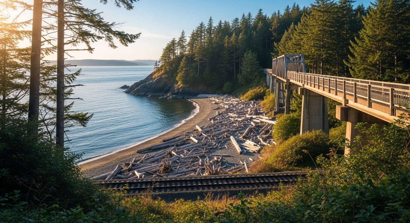
    That matters, because Riverside is the neighborhood that most directly connects modern Everett to its sawmill-and-railroad origin story. The Snohomish River isn’t a view from Riverside — it’s the eastern property line. Stand at the top of Summit Avenue and you’re looking at the same ridge workers climbed home to after a shift at the waterfront mills a hundred and thirty years ago.

    Where Riverside actually is

    If you’re new to Everett, the boundaries are easy to hold in your head:

    • North: 19th Street
    • South: Pacific Avenue
    • East: the Snohomish River
    • West: Broadway

    Broadway is the western artery — the wall that separates Riverside from the Bayside grid to the west. Everything between Broadway and the river is Riverside. That’s a rectangle roughly a mile wide and a mile and a half tall, cut through by Everett Avenue, Hewitt Avenue, Pacific Avenue, and a whole lot of quiet residential streets that most Everett residents have driven past without ever knowing they were there.

    Six parks in one neighborhood

    Riverside’s quiet superpower is parks. For a neighborhood this small, the park inventory is remarkable — and most of them are the kind of parks only locals know about.

    Garfield Park (23rd & Walnut)

    The anchor park. Baseball fields, a playground, a walking track, pickleball courts, basketball, tennis courts — all in one footprint. Garfield is the park where Riverside kids grow up, Little League seasons happen, and pickleball players have been quietly organizing for years. The city has an active renovation plan in motion, and we’ve covered the Garfield makeover separately.

    Riverside Park (Everett Avenue & East Grand)

    A viewpoint park at the east end of Everett Avenue overlooking the Snohomish River and the Cascade foothills beyond. There’s a little free library here. The view at sunrise is arguably the best unofficial viewpoint in Everett — and one that almost no tourist guide mentions.

    Summit Park (Summit Avenue)

    The highest point in Riverside. On a clear day you can see the Cascade Mountains from Summit, which is why generations of Riverside families have walked up there to watch the Fourth of July fireworks.

    JJ Hill Park (Hewitt & Broadway)

    A pocket park at the western edge — small, but it does the job of breaking up the Hewitt-Broadway intersection with a patch of green.

    Judd & Black Park (Hewitt Avenue & Maple)

    Another small neighborhood park — the kind of place where locals walk their dogs on the way back from the grocery store and nobody else stops.

    The Snohomish Riverfront

    Technically not a city park, but functionally one — the Snohomish Riverfront Trail system runs along the eastern edge of the neighborhood, and the Lowell Riverfront Trail extension sits a short walk south. Snohomish County has been acquiring former Puget Sound Energy corridor parcels since 2020 for the Snohomish River Trail Phase 1, which will eventually knit the whole riverfront together from Everett to Snohomish.

    The neighborhood association that actually runs things

    The Riverside Neighborhood Association is one of Everett’s most active. Residents are automatically members — no sign-up, no dues. The association uses mini-grants from the City of Everett to fund community programs, organize events, and lobby on neighborhood infrastructure questions.

    That “automatically a member” structure matters. It means the neighborhood association isn’t a small club of the same ten people — it’s a framework that lets anyone on any Riverside block show up to a meeting and count. If you just moved in, you already belong.

    What it’s like to live here

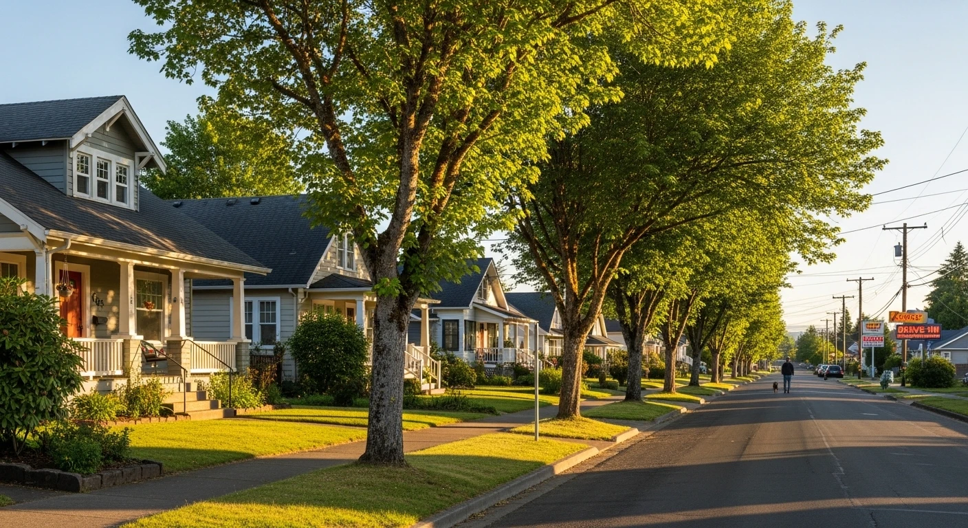
    Riverside’s housing stock is older than almost anywhere else in Everett, which means you get the good and the quirky. Craftsman houses with original woodwork. Mid-century ramblers. The occasional Victorian holdout. Streets that don’t quite line up with the rest of the city because they were laid out before the modern grid was imposed. Mature trees that give the neighborhood a canopy most Everett neighborhoods haven’t had time to grow.

    It’s also one of the most walkable non-downtown neighborhoods in the city. Hewitt Avenue runs through it. Everett Avenue runs through it. You can walk from central Riverside to downtown Everett in fifteen minutes and to the riverfront in ten.

    The demographic profile tilts toward a mix of long-time residents and younger households who’ve figured out that Riverside offers Everett’s most house for the money once you get east of Rucker. Rentals make up about half the housing stock, but owner-occupancy is higher here than in many central Everett neighborhoods.

    What long-timers say

    The thing longtime Riverside residents repeat, almost verbatim, is that the neighborhood is underrated — and they’d prefer to keep it that way. It doesn’t have the waterfront cachet of Bayside. It doesn’t have the lake of Silver Lake. What it has is history, parks, the river, and a neighborhood association that actually meets and actually gets things done.

    If you’re reading a Riverside neighborhood guide, you’re probably already the kind of person who would fit in here.

    Getting around

    Broadway and Rucker handle the north-south traffic. Hewitt, Everett, and Pacific handle the east-west. I-5 is a five-minute drive west. The Snohomish Riverfront Trail is a walk east. The Everett Transit Station is a mile south, which puts commuters on a Sound Transit bus to Seattle without needing to drive to a park-and-ride.

    For the riverfront trail connection specifically, the Mill Town Trail loop ties the Port of Everett waterfront to Riverside Park via East Grand Avenue — a continuous six-plus-mile walking loop that uses Riverside as its eastern anchor.

    Frequently Asked Questions

    Where is the Riverside neighborhood in Everett?

    Riverside sits between 19th Street and Pacific Avenue on the north-south axis, and between Broadway and the Snohomish River on the east-west axis. It’s directly east of Bayside and directly north of the Port Gardner / Pacific Avenue corridor.

    Is Riverside really Everett’s oldest neighborhood?

    Yes. The first plat in what is now Riverside was filed in September 1891 — earlier than the main plat of Everett itself. The neighborhood’s eastern blocks trace directly back to that filing.

    How many parks are in Riverside?

    Five official city parks sit inside the neighborhood: Garfield Park, Riverside Park, Summit Park, JJ Hill Park, and Judd & Black Park. The Snohomish Riverfront Trail corridor runs along the eastern edge, adding a sixth functional green space.

    Does Riverside have a neighborhood association?

    Yes. The Riverside Neighborhood Association covers the entire boundary area. Residents are automatically members, there are no dues, and the association uses City of Everett mini-grants to fund neighborhood programs.

    Is Riverside a good place to live in Everett?

    For buyers and renters who value walkability, older housing stock, mature trees, and proximity to both downtown Everett and the Snohomish River, Riverside is among the strongest options in the city. It sits outside the price pressure of the waterfront and the density of downtown while keeping a short walk to both.

    What’s the history of Garfield Park?

    Garfield Park is one of Everett’s oldest named parks, anchored at 23rd and Walnut. It has grown into a multi-use facility with baseball fields, a playground, a walking track, pickleball, basketball, and tennis — and the city is currently advancing a formal renovation plan for the park.

    How do I join the Riverside Neighborhood Association?

    You already did. If you live inside the Riverside boundaries — 19th Street to Pacific Avenue, Broadway to the river — you are automatically a member and can attend any association meeting or event without signing up or paying dues.

    Related

  • Jetty Island Ferry Returns July 8: Your Complete 2026 Guide to Everett’s Best Free Beach

    Jetty Island Ferry Returns July 8: Your Complete 2026 Guide to Everett’s Best Free Beach

    Q: When does the Jetty Island ferry open in 2026?
    A: The Jetty Island passenger ferry runs July 8 through September 6, 2026, Wednesday through Sunday. Reservations are required and cost $4 per person Wed-Thu and $7 Fri-Sun. Children 2 and under ride free. The ferry departs from Jetty Landing at 10th Street and W. Marine View Drive in Everett.

    Jetty Island Ferry Returns July 8: Your Complete 2026 Guide to Everett’s Best Free Beach

    Mark July 8 on the calendar. That’s the day the Jetty Island ferry season officially starts in 2026, and that’s the day Everett’s two-mile-long sandy island park becomes accessible again to anyone who can get to the marina. The ferry runs through September 6 — exactly two months of the only beach in Western Washington that actually feels like a beach.

    If you’ve never made the trip, here’s the short version: Jetty Island is a man-made, two-mile-long sandbar just off the Port of Everett, separated from the mainland by a narrow channel. There’s warm water on the inner shoreline (the channel side warms up in the summer sun), wind for kiteboarders on the outer shoreline, miles of walking, and almost no infrastructure. Bring what you need, take what you brought. That’s the deal.

    The 2026 Ferry Schedule

    The passenger ferry runs Wednesday through Sunday from July 8 through September 6, 2026. Operating hours by day:

    • Wednesday and Thursday: 10 AM to 5:45 PM
    • Friday and Saturday: 10 AM to 6:45 PM
    • Sunday: 10 AM to 5:45 PM
    • Monday and Tuesday: No ferry service

    The ferry departs from Jetty Landing, which is right next to the boat launch at the corner of 10th Street and W. Marine View Drive in Everett. There’s parking near the launch, but on a hot weekend in August it fills up fast. Get there early or be prepared to walk a few blocks.

    Reservations Are Required (Yes, Even on Weekdays)

    This is the part that trips up first-timers. You cannot just show up. All ferry rides require advance reservations through the Port of Everett’s reservation system. Walk-up tickets are not sold at the dock.

    Pricing for 2026:

    • Wednesday-Thursday: $4 per person
    • Friday-Sunday: $7 per person
    • Children 2 and under: Free

    Applicable taxes and a small booking fee apply at checkout. Reservations open up at portofeverett.com — and for prime weekend slots in July and August, they go fast. If you know you want to be there a particular weekend, book it the moment the schedule goes live.

    What You Need to Know Before You Go

    Jetty Island is intentionally left rustic. There are no concessions. There is no drinking water. There are vault toilets and that’s it. Pack:

    • Water — more than you think you need. Two miles of beach in August sun without shade is a long day.
    • Sunscreen and a hat — there is genuinely zero shade on most of the island.
    • Snacks/lunch — and a trash bag. Pack out what you pack in.
    • Wind layer — even on hot days the outer beach gets a steady afternoon wind off the Sound.
    • Beach toys, a kite, or a paddleboard — the channel side is calm and warm enough for all-day water play.

    Pets are allowed, but they need to stay on leash. There’s no lifeguard service. Watch the tide schedule — at extreme low tides the channel between the mainland and the island gets shallow enough to expose long stretches of mudflat, which is fascinating to look at and miserable to walk through.

    Why the Ferry Closes Early on Hot Days

    This is the one operational quirk to plan around. When the island reaches maximum capacity — which happens on hot weekends in late July and August — the ferry can stop running new round-trips early. The return ferries still operate to bring everyone back, but if you show up at 2 PM on a 90-degree Saturday and the ferry is paused, your reservation may not get you across. Earlier is better.

    Inclement weather can also cancel ferry service. The Port posts updates on the day-of through their site and social channels.

    The Things People Don’t Realize About Jetty Island

    The water is actually warm. The channel side, sheltered from the Sound, gets shallow and sun-heated through the day. Kids can wade for hours. It’s the warmest swimming water you’ll find anywhere in Snohomish County.

    It’s a kiteboarding hotspot. The outer shoreline catches a consistent westerly afternoon wind in summer, and the local kiteboarding community treats Jetty as one of the best spots in the region. If you’ve ever wanted to watch the sport up close, head to the south end of the island in the late afternoon.

    The bird life is wild. Jetty is on the Pacific Flyway and is a Snohomish County designated wildlife area. Bald eagles, herons, oystercatchers — bring binoculars if you’re into that.

    You can paddle there. If the ferry is full or you’ve got your own kayak or paddleboard, the channel from the marina is short, calm, and well within reach for a casual paddler. Bring a leash for your board and a PFD.

    Getting to Jetty Landing

    Jetty Landing is at 1700 W. Marine View Drive, right next to the Port of Everett’s 10th Street boat launch. From I-5, take exit 193 (Pacific Avenue) and head west until Marine View Drive, then turn north. The boat launch parking lot is signed.

    Everett Transit’s Route 7 stops within about a half-mile walk if you’d rather not deal with parking. On weekends the bike racks at Jetty Landing fill up too, which tells you something about who knows what they’re doing.

    What to Do After the Beach

    Coming back from a Jetty day around 5 or 6 PM puts you right at the Port of Everett’s Waterfront Place — which has the best dinner options in the area and is about a five-minute walk from where you’ll dock. Tapped Public House, Rustic Cork, and the new Sound to Summit taproom on the south side of the marina are all right there. The Net Shed Fish Market & Kitchen is another great option for a casual dinner with a view.

    Make a day of it: ferry over for a morning swim, beach lunch, kite-watching afternoon, then dinner on the waterfront when you get back. That’s an Everett summer Saturday done right.

    The Big Picture: Jetty Days 2026

    The Port of Everett’s Jetty Island Days programming runs alongside the ferry season July 8 – September 6, with naturalists, environmental education programs, and family activities scheduled throughout. The full programming calendar typically goes live in mid-June. Watch portofeverett.com for the schedule.

    This is a free island park (the only cost is the ferry ride). It is a genuinely unusual asset for a city the size of Everett. And once you’ve been once, you’ll find a reason to go back every summer.

    Frequently Asked Questions

    When does the Jetty Island ferry open in 2026?
    July 8, 2026.

    When does the ferry season end?
    September 6, 2026.

    How much is the ferry?
    $4 per person Wednesday-Thursday, $7 per person Friday-Sunday. Children 2 and under ride free.

    Where do I make ferry reservations?
    Through portofeverett.com. Reservations are required — there are no walk-up tickets.

    Where does the ferry leave from?
    Jetty Landing at 10th Street and W. Marine View Drive in Everett, next to the Port of Everett boat launch.

    What days does the ferry run?
    Wednesday through Sunday. No ferry service Monday or Tuesday.

    Can I bring my dog to Jetty Island?
    Yes, dogs are allowed but must be on leash.

    Is there food on Jetty Island?
    No — bring your own food, water, and pack out all trash.

    Can I kayak or paddleboard to Jetty Island?
    Yes. The channel from the marina is short and calm in good weather. Wear a PFD and use a board leash.

    Are there bathrooms on the island?
    Yes, vault toilets only. No running water.

    Can the ferry be canceled?
    Yes, the ferry may close due to weather or when the island reaches maximum capacity on busy days. Check portofeverett.com for day-of updates.

  • Eclipse Mill Park Gets a New Timeline: Why Everett’s Riverfront Signature Park Is Now a Spring 2028 Opening

    Eclipse Mill Park Gets a New Timeline: Why Everett’s Riverfront Signature Park Is Now a Spring 2028 Opening

    Featured Snippet

    Q: When will Eclipse Mill Park at Everett’s Riverfront actually open?

    A: The park will now be built in two phases. The City of Everett’s waterside portion — the pier, floating dock, playground, and fish habitat work — starts July 2026 and wraps in November 2026 after the Washington Department of Ecology pushed the original start back for additional site-condition review. The second, larger phase, built by developer Shelter Holdings, runs from fall 2026 through spring 2028, with the full Eclipse Mill Park opening projected for spring 2028.


    Eclipse Mill Park Gets a New Timeline: Why Everett’s Riverfront Signature Park Is Now a Spring 2028 Opening

    We’ve been watching the Riverfront development on the west bank of the Snohomish River for years now, and if you drive past it on the way to the new Costco at I-5 and 41st, you already know the shape of the thing. Apartments are up. Retail pads are framed out. The trail along the river is there if you know where to look for it. But the piece that was supposed to tie the whole development together — Eclipse Mill Park, the 3-acre public park that’s going to be the signature green space for the new neighborhood — has a new timeline, and it’s worth understanding what changed.

    Here’s where things actually stand as of late April 2026, and what it means for the Riverfront buildout.

    The Short Version: A Two-Phase Park With Two Different Builders

    Eclipse Mill Park isn’t being built as a single contract or by a single entity. The 3-acre park is split into two phases, with two different builders on two different timelines. That’s the first thing to understand, because the confusion over “when does the park open” has largely come from people treating it as one project when it’s really two.

    Phase 1 — City of Everett’s portion. This is the waterside end. Playground. Pier. Floating dock. Fish habitat improvements along the riverbank. The City Council approved a $3.6 million construction contract last May to build this phase.

    Phase 2 — Shelter Holdings’ portion. This is the upland section of the park, built by the private developer as part of their Development Agreement with the City. This is the larger portion of the park’s 3 acres.

    Two builders. Two contracts. Two timelines. And two different reasons the opening keeps sliding.

    Why Phase 1 Slid to July 2026

    The original plan had City of Everett crews starting Phase 1 work earlier, with the waterside amenities coming online in 2026. That timeline got redrawn after the Washington Department of Ecology requested additional review of site conditions along the riverbank — a standard request for any project that touches fish habitat on a river as ecologically significant as the Snohomish.

    The revised schedule now has:

    • Construction mobilization: July 2026
    • Waterside amenities complete: November 2026

    So the pier, the floating dock (which Port officials have said could eventually be used to launch personal watercraft), the playground, and the fish habitat restoration work are all targeting a late-2026 completion on the City’s end. That’s a real, visible change Riverfront residents will see this year — crews on site by midsummer, open amenities by late fall.

    Why Phase 2 Runs Fall 2026 to Spring 2028

    Once the City’s portion wraps, Shelter Holdings picks up the baton. Their phase of the park is scheduled from fall 2026 through spring 2028, which puts the full-park opening at spring 2028 — about 18 months later than anyone in the neighborhood was hoping when the Riverfront plan was first approved.

    Why so long? A few honest reasons. The Phase 2 work is the larger share of the 3 acres. It’s being built by the developer, not the City, which means it’s coordinated with the rest of the Shelter Holdings buildout — apartments, retail pads, parking, internal streets — and you can’t pour the signature park in the middle of active mixed-use construction without risking damaging it. So the park goes last, and it goes slow, and the opening date sits at spring 2028.

    What Gets Built: The Actual Park Design

    The published park program is generous for a 3-acre urban waterfront park. Here’s what the full build includes once both phases are done:

    • A waterfront pier extending into the Snohomish River
    • A floating dock sized for personal watercraft launch
    • A playground at the City’s end of the park
    • A signature open lawn and gathering space on the Shelter Holdings side
    • Fish habitat improvements built into the riverbank along the full frontage
    • Trails connecting the park to the broader Riverfront trail network
    • Integration with the apartments and retail to the east so the park reads as the neighborhood’s front porch, not just leftover space

    It’s not the acreage of Grand Avenue Park or Forest Park. But for the kind of neighborhood Riverfront is trying to become — dense, mixed-use, transit-accessible, and built on a former industrial site — a 3-acre programmed park with a working pier is a meaningful amenity.

    The Bigger Picture: Riverfront’s Slow Build Continues

    Eclipse Mill Park’s slip to 2028 is part of a pattern we’ve been tracking for a while. The Riverfront project was originally approved as a 40-acre, 1,250-unit mixed-use development that would include a multiplex cinema, a specialty grocer, a 250-room hotel, office space, and 3 acres of park. The cinema has since been swapped for pickleball courts (reflecting where the indoor entertainment dollar is going in 2026), the grocer has moved around on the site plan, and the timeline for each piece has shifted.

    Two mixed-use apartment buildings are already up. Phase 2 housing — the piece that really fills out the neighborhood — is underway. The hotel is still a future phase. And now the park, which was supposed to open alongside Phase 2 apartments, slides to 2028.

    None of this is unusual for a redevelopment of an old industrial site on a federally regulated river. Every interaction with Ecology, every seasonal fish window, every shared utility trench adds weeks. If you’ve watched any of Seattle’s waterfront projects unfold, you know the shape of it.

    What Residents Will Actually See This Year

    Even with the park pushed to 2028, there’s real work happening on the Riverfront waterline this year that residents can watch in real time:

    • Summer 2026: City crews mobilize for Phase 1 park construction. Expect fencing, equipment staging, and in-water work during the permitted fish window.
    • Fall 2026: Phase 1 waterside amenities near completion. The pier and floating dock take shape.
    • November 2026: City portion hits substantial completion.
    • Fall 2026 — concurrent: Shelter Holdings begins Phase 2 park construction, running through 2027.
    • Through 2026-2027: Remaining Shelter Holdings residential buildings continue vertical construction.

    The Riverfront trail along the Snohomish River stays open throughout, which is the piece most residents actually use day to day. If you walk the trail now, you’ll see the raw edge where the riverbank will be reshaped for fish habitat — watching that transform from fall through next year is going to be one of the more visible pieces of construction on the east side of Everett.

    How the Riverfront Delay Compares to Waterfront Place

    For context, the Waterfront Place development over on the Port of Everett side is running its own slipping timeline. Millwright District Phase 2 is breaking ground this year with 300+ apartments targeting tenant move-ins by late 2026, but the Class-A office buildings aren’t expected to open until as early as 2028. S3 Maritime just opened. Menchie’s and Marina Azul are in the pipeline. The flagship restaurant parcel is still in tenant search.

    Both the Riverfront and the Waterfront are doing the same kind of work on different sites — converting former industrial edges into mixed-use neighborhoods, with parks, restaurants, and apartments. Both are running into the same realities: Ecology review windows, developer coordination, fish seasons, infrastructure sequencing, and the plain fact that you can’t stand up a neighborhood in 18 months.

    The difference between watching these projects with frustration and watching them with curiosity is mostly about whether you understand what the timelines actually mean. An extra year on Eclipse Mill Park isn’t a failure — it’s the cost of doing riverbank restoration right, in a phased build, with a private developer stitching into a public park.

    What Comes Next

    The next milestone to watch is July 2026 mobilization at the park’s waterside. If that holds, the Phase 1 amenities will be open by Thanksgiving. Shelter Holdings’ Phase 2 timeline is tied to the rest of their buildout, so the next market update on Riverfront housing will be the better indicator of whether the park’s 2028 opening slips again.

    We’ll be back at the Riverfront site later this summer with photos once the fencing goes up and the equipment stages in. If you’re a resident of one of the existing Riverfront buildings and you see activity before then, we want to know what you’re seeing from your windows.

    Frequently Asked Questions

    When will Eclipse Mill Park open in Everett?

    The full 3-acre park is projected to open in spring 2028. The City of Everett’s phase (playground, pier, floating dock, fish habitat work) is scheduled to be complete by November 2026, but the full park including Shelter Holdings’ Phase 2 won’t open until spring 2028.

    Why was Eclipse Mill Park delayed?

    The Washington Department of Ecology requested additional review of site conditions along the riverbank, which pushed construction mobilization to July 2026. The Phase 2 timeline is tied to developer Shelter Holdings’ broader Riverfront buildout.

    Who is building Eclipse Mill Park?

    Two builders. The City of Everett is building Phase 1 (waterside amenities) under a $3.6 million construction contract approved by the City Council in May. Shelter Holdings, the private developer of the Riverfront project, is building Phase 2 (the larger upland portion) under their Development Agreement with the City.

    What will be in Eclipse Mill Park?

    A pier, floating dock for personal watercraft, playground, open lawn and gathering space, fish habitat improvements along the Snohomish riverbank, and trails connecting to the broader Riverfront trail system.

    Where is the Riverfront development in Everett?

    Riverfront is on the west bank of the Snohomish River, east of I-5, near the Hewitt Avenue Trestle. It’s a 40-acre former industrial site being redeveloped into a mixed-use neighborhood with housing, retail, a hotel, and parks.

    How is Riverfront different from Waterfront Place?

    Riverfront is on the Snohomish River on Everett’s east side, developed by Shelter Holdings. Waterfront Place is on Puget Sound on Everett’s west side, developed by the Port of Everett with various partners. Both are converting former industrial sites into mixed-use neighborhoods — they just face different waterways.

    What else is happening at Riverfront in 2026?

    Phase 2 residential construction continues. The cinema originally planned has been replaced with pickleball courts. Remaining apartment buildings are under vertical construction. The Riverfront trail stays open throughout construction.

  • Living in Boulevard Bluffs: Everett’s Best-Kept Secret Neighborhood

    Living in Boulevard Bluffs: Everett’s Best-Kept Secret Neighborhood

    Featured answer: Boulevard Bluffs is a quiet residential neighborhood on Everett’s southwestern edge, perched above Possession Sound with Olympic Mountain and Port Gardner Bay views, close to Harborview, Edgewater and Forest Park, with a neighborhood association that meets at Fire Station 4 every other month.

    Living in Boulevard Bluffs: Everett’s Best-Kept Secret Neighborhood

    If you have ever driven down Mukilteo Boulevard at sunset and felt the road open up toward the water, you have already gotten a taste of Boulevard Bluffs. This is the corner of Everett that most people pass through on their way somewhere else — commuting between Mukilteo and downtown, or heading out to the Boeing plant at Paine Field. Locals will tell you that is part of the charm. Boulevard Bluffs is not trying to sell itself to anyone. It is just quietly one of the best places in the city to wake up in the morning.

    Set on Everett’s western edge above Port Gardner Bay, Boulevard Bluffs is a mostly residential neighborhood of single-family homes, a handful of larger apartment communities on its south side, and some of the most consistent water and mountain views in Snohomish County. It is part of a wider crescent of Everett neighborhoods that hug the shoreline, but it tends to get less attention than the showier waterfront zones further north. Most of its housing stock was built between the 1940s and the 1990s, with a mix of mid-century ramblers, 1970s split-levels, and newer infill homes closer to the bluff’s edge.

    Where exactly is Boulevard Bluffs?

    The neighborhood sits in southwest Everett, bounded roughly by Mukilteo Boulevard to the north, Glenwood Avenue to the east, and the residential blocks that step down toward the water to the west. From most of the neighborhood’s higher streets you can see the Olympics, the Mukilteo ferry lanes, and on the clearest days the dark line of the Kitsap shoreline across the Sound. The south side of the neighborhood blends into commercial and multifamily housing along Evergreen Way, which is how most residents get to Interstate 5 and back north to the rest of Everett.

    It is not a walkable urban neighborhood in the way that Bayside or North Broadway can be. It is a car-first neighborhood. But it is also a neighborhood where it is completely normal to walk a dog for an hour without crossing anything busier than a residential street, and that is part of the appeal.

    The views are the thing

    Ask anyone who has lived in Boulevard Bluffs for more than a year what keeps them, and most of them will eventually mention the views. The bluff itself slopes steeply from the residential streets down toward the railroad line and Possession Sound. That geography is the whole reason the area exists as a distinct neighborhood — the ridge breaks cleanly, and from above it the water is right there.

    That same geography is why the neighborhood is threaded with parks instead of dense development at the edge. Harborview Park and Edgewater Park sit along the bluff line and both offer some of the most accessible water-view picnic spots in Everett. Forest Park, while officially bordering the neighborhood rather than inside it, is close enough that a lot of Boulevard Bluffs residents treat it as their backyard — with its off-leash dog area, playgrounds, and the long-running Animal Farm. Mukilteo’s Lighthouse Park, with its beach access, boat launch and fire pits, is a short drive away and shows up on a lot of Boulevard Bluffs weekend itineraries in the summer.

    Who lives here

    According to public demographic data compiled by Homes.com and NeighborhoodScout, Boulevard Bluffs skews toward homeowners — roughly two-thirds of occupied housing units are owner-occupied — with a median household income above the Everett average. The community is a mix of long-tenured families who have been there since the 1980s or earlier, younger buyers who traded down from Seattle for view property, and a meaningful renter population in the larger apartment communities on the neighborhood’s south edge.

    If you look at the conversations neighbors have about the area in public community forums, a few words come up repeatedly: quiet, family-friendly, dog-friendly, safe, walkable within the residential streets. It is the kind of neighborhood that puts out trick-or-treat bags and posts Ring videos of raccoons rather than incidents. That is not to say the neighborhood is without its frustrations — traffic on Mukilteo Boulevard during the commute, the usual aging-infrastructure issues that come with a neighborhood built mostly mid-century, and the ongoing debate over how much new density the south side should absorb are real conversations — but the dominant mood is contented.

    The neighborhood association

    Boulevard Bluffs is one of Everett’s recognized neighborhood associations. According to the City of Everett’s neighborhood associations listing, the group meets on the third Thursday of every other month at 7:00 p.m. at Fire Station 4, located at 5920 Glenwood Avenue. The bi-monthly cadence is a small but important thing — it means the association can dig into bigger agenda items per meeting rather than scrambling to fill a monthly calendar.

    Neighborhood associations in Everett do not have formal legal authority over development, but they are the main vehicle residents have for organizing around local issues, weighing in on city planning proposals, and coordinating things like community cleanups and National Night Out events. For anyone new to the neighborhood, showing up to a meeting is the fastest way to meet the people who actually know what is happening on the ground.

    What’s changing

    Boulevard Bluffs is not in the middle of a transformation the way the Everett waterfront or the downtown core are. But that does not mean nothing is moving. The steady build-out of Mukilteo to the west, the ongoing growth at Paine Field, and Everett’s own push for more housing along Evergreen Way all show up in small ways on this side of the city — a new apartment complex here, an infill house on a previously overlooked lot there, traffic patterns that shift when a major employer changes its schedule.

    The broader Everett story — Boeing’s 737 North Line opening this summer, the downtown stadium debate, the Sound Transit light rail extension — does not hit Boulevard Bluffs directly the way it hits Riverside or North Broadway. But the housing-market pressure that comes with it absolutely reaches here. Median sale prices in the neighborhood moved up meaningfully over the past several years as buyers priced out of Seattle looked for view property at suburban prices, and long-timers talk about that shift the way you would expect long-timers to.

    Favorite local spots

    Boulevard Bluffs is not a restaurant destination — the commercial corridor is on Evergreen Way and along Mukilteo Boulevard, and most of the dining energy locals participate in is over in Harborview or downtown. But the neighborhood has its anchors. Residents treat the Mukilteo Boulevard corridor as their main thoroughfare for coffee and groceries. Forest Park is the unofficial town square. And the loop of residential streets just above the bluff is a walking route that locals genuinely use — it is not unusual to see the same handful of neighbors doing an evening loop with dogs, strollers, and the occasional beer.

    Is Boulevard Bluffs a good place to live?

    If your idea of a good neighborhood is a quiet, family-oriented, view-forward residential area with easy access to parks, a sub-twenty-minute drive to Boeing or downtown Everett, and an active neighborhood association that meets at the fire station — yes, Boulevard Bluffs is exactly that. If you want restaurants, nightlife, or a dense walkable urban feel, you will probably want to be downtown or in Bayside instead. Both are fifteen minutes away. That is part of why Boulevard Bluffs works: you can live here and still touch the rest of Everett whenever you want.

    For a neighborhood that does not market itself, Boulevard Bluffs has a clear identity. It is Everett’s quietly good corner. The people who find it tend to stay.

    Frequently Asked Questions

    Where is Boulevard Bluffs in Everett?

    Boulevard Bluffs is in southwest Everett, along Mukilteo Boulevard, perched above Possession Sound with views of Port Gardner Bay and the Olympic Mountains. It sits between the Mukilteo city line and the Evergreen Way corridor.

    When does the Boulevard Bluffs Neighborhood Association meet?

    Per the City of Everett’s official neighborhood associations page, the association meets on the third Thursday of every other month at 7:00 p.m. at Fire Station 4, 5920 Glenwood Avenue, Everett, WA 98208.

    What parks are in or near Boulevard Bluffs?

    Harborview Park and Edgewater Park sit along the bluff with water views. Forest Park — with its Animal Farm, off-leash area and playgrounds — is just east of the neighborhood. Mukilteo’s Lighthouse Park, with beach access, is a short drive west.

    Is Boulevard Bluffs a good place to live?

    For a quiet, view-forward, family-oriented neighborhood with active parks and a short commute to Boeing and downtown Everett, yes. It is not where you go for nightlife or a walkable urban core — for that, Bayside or downtown Everett are nearby.

    What schools serve Boulevard Bluffs?

    Boulevard Bluffs is served by Mukilteo School District and Everett Public Schools depending on the specific address. Families confirm school assignment via the school district’s attendance boundary tools. Highly rated neighborhood elementary schools are in the surrounding Harborview-Seahurst-Glenhaven area.

    How did Boulevard Bluffs get its name?

    The name comes from its geography — the neighborhood sits on a bluff above the water, running along Mukilteo Boulevard. Like many Everett neighborhoods, it developed out of the city’s southward residential expansion in the mid-20th century.

    Is Boulevard Bluffs walkable?

    Within its residential streets, yes — it is one of the most pleasant walking neighborhoods in Everett. It is not walkable in the urban sense of having shops and restaurants at every corner. For that, it is a short drive to Mukilteo, Bayside, or downtown Everett.

  • Howarth Park: The Everett Beach You Drive Past Without Knowing It’s There

    Howarth Park: The Everett Beach You Drive Past Without Knowing It’s There

    What is Howarth Park in Everett?
    Howarth Park is a City of Everett park on the Puget Sound bluff at 1127 Olympic Boulevard, with an easy 0.6-mile loop trail, a pedestrian bridge over the BNSF railroad tracks to a long beach, sport courts, a playground, and an off-leash dog beach on the north end. It’s open 6 a.m. to 9 p.m. daily, free to enter, and one of the most underused public beaches in Snohomish County.

    Howarth Park: The Everett Beach You Drive Past Without Knowing It’s There

    Olympic Boulevard in south Everett is mostly tidy residential streets, a few stop signs, and not much else to look at — which is exactly how most drivers end up cruising right past Howarth Park without noticing the turnoff. That is the central fact of this park. It’s one of the most scenic stretches of public beach in south Everett, it’s a short drive from downtown, and a huge number of Everett residents have never set foot on it.

    Let’s fix that.

    Where Howarth Park Actually Is

    Howarth Park is tucked along the western bluff of south Everett at 1127 Olympic Boulevard. Coming from downtown, the easiest route is south on Rucker Avenue, right on Mukilteo Boulevard, and then left into the park about a mile and a half after you pass Forest Park. If you hit the Mukilteo ferry, you’ve gone too far.

    The park sits on a long, narrow strip of bluff and beach that the City of Everett has owned and managed for generations. The bluff side holds the parking, playground, and sport courts. The beach is a separate world down below — reached only by the park’s signature pedestrian bridge.

    The Three Parking Lots and What Each One Gives You

    One of the things that confuses first-time visitors is that Howarth Park has three parking lots, and they’re not interchangeable. Pick the wrong one and you’ll either end up with a long walk or a missed view.

    The north parking lot is what most beach-goers want. This is the closest pedestrian access to the beach itself. A short trail leads from the lot to the park’s pedestrian bridge, which spans the BNSF railroad tracks below and drops you directly onto the sand. If your goal is to get to the water with kids, a dog, or a beach chair, this is the lot.

    The central parking lot sits at a small viewpoint on the bluff and offers a trail that drops down the hillside to the beach. This route is longer and steeper than the north access, but the view from the top is easily the best non-beach view in the park — on a clear day you’re looking straight across at the Olympic Mountains and Hat Island.

    The south parking lot is the one most Everett residents don’t realize exists. This is the family-friendly end: two sport courts (tennis and basketball), a playground, a restroom, and a short, level walking path that leads to another great water view — again with Hat Island front and center. If you have young kids and want a picnic without the pedestrian-bridge hike, come here.

    The Pedestrian Bridge and the Beach

    The pedestrian bridge over the railroad tracks is the quintessential Howarth experience. It’s not fancy — a metal walkway with railings — but it feels a little bit like crossing into a hidden world. You come off the bridge onto a long, driftwood-strewn beach with Possession Sound in front of you, Whidbey Island in the distance, and the Mukilteo ferry crossing behind you.

    The beach itself runs north to south along the park’s full length. It’s sand and cobble, with plenty of driftwood washed up at the high-tide line and tide pools exposed at low tide. You’ll see people walking dogs, kids skipping rocks, the occasional fisherman, and on nice spring weekends, a handful of photographers chasing the light.

    The freight trains that run on the tracks behind you are loud and constant — that’s the tradeoff for beach access in this part of Puget Sound. After your first trip you stop noticing them.

    The 0.6-Mile Loop Trail

    On the bluff above, Howarth has a short but scenic 0.6-mile loop trail that’s generally rated as easy. It takes most people about 15 to 20 minutes and connects the three parking lots through a mix of forested switchbacks and bluff-edge sections. Strollers can handle some of it but not all. Dogs on leash are fine.

    The trail is at its best between March and September, when the alders have leafed out and the ground is dry. In winter the steeper descents can get muddy and slick — bring shoes with tread.

    The Off-Leash Dog Beach

    Here’s a Howarth detail most Everett dog owners don’t know until their neighbor tells them: the north end of the beach is off-leash. Everett has very few legal off-leash beach options, and this is one of them. The south half of the beach stays leashed, but if you walk north from the pedestrian bridge, your dog can run.

    Standard rules apply: owners are responsible for cleanup, voice control, and pulling your dog back if another leashed dog or visitor is coming through. The regulars who use this stretch have an informal etiquette that works well — show up, be considerate, and you’ll be welcomed.

    The Views and When to Come

    Howarth faces roughly west-southwest across Possession Sound. That geometry means:

    • Morning: Calm water, often glassy, great for reflective photos and cool-weather walks.
    • Golden hour to sunset: The main event. The sun drops behind Hat Island and the Olympics light up pink and orange. This is the time to come.
    • Overcast days: Still beautiful. The moody gray sky and driftwood beach are some of the most Pacific Northwest scenery Everett has.

    Weekends in July and August get busy, especially the north lot. Weekday evenings are the sweet spot — you’ll often have long stretches of beach to yourself.

    Hours, Amenities, and Rules

    • Hours: 6 a.m. to 9 p.m. daily.
    • Cost: Free.
    • Parking: Three lots, no fee.
    • Restrooms: Available at the south lot.
    • Playground: South lot.
    • Sport courts: South lot (tennis and basketball).
    • Dogs: On leash in all park areas except the north end of the beach, which is off-leash.
    • Fires: Not permitted on the beach.
    • Alcohol: Not permitted in park facilities.

    Why Howarth Is Worth the Trip

    Everett has Jetty Island for ferry-ride summer beach days, Forest Park for forest walks and the animal farm, and Legion Memorial for views and golf. Howarth is the one that fills a different slot: a real, walkable Puget Sound beach you can drive to in ten minutes, stay on for two hours, and leave without feeling like you fought a crowd.

    It’s not flashy. It’s not a destination. It’s just quietly one of the best small parks in the city, and the Everett residents who use it regularly tend to keep it that way.

    Frequently Asked Questions

    Where is Howarth Park in Everett?

    Howarth Park is at 1127 Olympic Boulevard in south Everett, on the Puget Sound bluff between downtown Everett and Mukilteo. The easiest route from downtown is south on Rucker, right on Mukilteo Boulevard, and left into the park.

    What are the hours at Howarth Park?

    Howarth Park is open 6 a.m. to 9 p.m. daily, year-round.

    How do you get to the beach at Howarth Park?

    The quickest access is from the north parking lot. A short trail leads to a pedestrian bridge that spans the BNSF railroad tracks and drops you directly onto the beach. There’s also a longer switchback trail from the central parking lot that descends the bluff to the beach.

    Is Howarth Park dog-friendly?

    Yes. Dogs are allowed throughout the park on leash, and the north end of the beach is an off-leash area. Owners are responsible for cleanup and voice control.

    How long is the Howarth Park trail?

    The main loop trail is about 0.6 miles and generally takes 15 to 20 minutes. It connects the three parking lots through a mix of forested switchbacks and bluff-edge segments.

    Is there parking at Howarth Park?

    Yes. There are three free parking lots — north, central, and south. The north lot is closest to the beach via the pedestrian bridge. The south lot has the playground, restroom, and sport courts.

    Can you swim at Howarth Park Beach?

    Wading is common on warm days, but Puget Sound water is cold year-round and the beach is not a lifeguarded swim beach. Conditions are best-suited for beachcombing, dog walking, and tide-pooling at low tide.

    When is the best time to visit Howarth Park?

    Weekday evenings between March and September are ideal. The golden-hour to sunset window is the park’s best view. Weekend afternoons in mid-summer can fill the north parking lot — come early or arrive after 4 p.m. for easier parking.

    Is Howarth Park free?

    Yes. There is no entrance fee and parking is free at all three lots.


  • Living in Delta: Everett’s Quietly Great Middle Neighborhood

    Living in Delta: Everett’s Quietly Great Middle Neighborhood

    What is the Delta neighborhood in Everett?
    Delta is a quiet, mostly residential neighborhood at the northern end of Everett, Washington, between the Snohomish River and Broadway. Roughly 13,000 residents live there. It’s known for older single-family homes, long-running local staples like Ray’s Drive-In and Tampico Mexican Restaurant, a big off-leash dog park, and some of the most affordable housing in north Everett.

    Living in Delta: Everett’s Quietly Great Middle Neighborhood

    Drive up Broadway from downtown Everett and somewhere past Providence Regional Medical Center, you cross into Delta without anyone telling you. There’s no gateway sign, no big intersection marking the change. The blocks just start feeling a little older, a little quieter, a little more lived-in. That’s Delta: one of Everett’s most populous neighborhoods and almost certainly its most underrated.

    If you’ve only driven through, you’ve probably missed it. Delta is not a destination neighborhood — it’s a living neighborhood, and that’s exactly what makes it good.

    Where Delta Is and What It Looks Like

    Delta sits at the northern end of Everett, bounded roughly by the Snohomish River to the north and east, Broadway running through its spine, and the Bayside and Northwest Everett neighborhoods to the west. It’s one of the largest of Everett’s 21 officially recognized neighborhoods by population, with around 13,000 residents according to recent census data.

    What you see when you walk it: 1920s craftsman bungalows next to 1940s workers’ cottages next to tidy early-2000s townhomes in the north end. Tree-lined streets. Basketball hoops in driveways. The occasional well-loved ’90s Tacoma in the front yard. It’s the kind of neighborhood where the housing stock has been continuously lived in for a hundred years because no one ever had a reason to leave.

    The Local Staples That Define Delta

    Every neighborhood has the places that anchor it. In Delta, two of them have been anchoring since before most current residents were born.

    Ray’s Drive-In has been flipping burgers and scooping ice cream on Broadway since 1962. That’s 64 years of the same drive-up counter, the same red-and-white signage, the same deep-fried fries that come out almost too hot to eat. Generations of Everett teenagers have had their first after-practice cheeseburger here. Generations of Delta residents have walked over for a shake on a summer evening. If you want to understand how Delta feels about itself, watch the parking lot at Ray’s on a Friday night.

    Tampico Mexican Restaurant opened in 1987 and has been serving tostadas and margaritas to Delta regulars ever since. It’s not flashy. The salsa is good. The prices are what Everett prices used to be everywhere, and the booth you sat in last year is probably still open when you come back.

    The Broadway corridor through Delta also includes a rotating cast of smaller shops, family-owned services, and the quiet kind of storefronts — dry cleaners, barbers, a tire place, a dentist — that keep a neighborhood running without ever becoming “scenes.”

    Who Lives in Delta and What It Costs

    Delta has historically been one of the most affordable neighborhoods in north Everett, and that’s still largely true — with an asterisk the rest of the Puget Sound region has stamped on everything.

    Two-bedroom 1940s bungalows trade in the $380,000 to $430,000 range. A three-bedroom 1920s craftsman lands closer to $470,000. Newer three-bedroom townhomes in the north end of the neighborhood go between $580,000 and $630,000. None of those numbers are cheap in absolute terms, but compared to similar homes in Northwest Everett or Bayside, Delta consistently comes in lower.

    The result is that Delta has stayed one of the most economically mixed neighborhoods in the city. You get long-time Everett families who bought their homes in the ’80s and never left, young couples stretching to buy their first place, and renters in the older duplexes and fourplexes that dot the side streets. That economic mix is probably Delta’s single most underappreciated quality.

    Schools and the Providence Connection

    Many Delta kids attend Hawthorne Elementary School, part of the Everett School District, which has a long-standing presence in the neighborhood. Middle and high school assignments in Delta run through the district’s standard boundary system, with most students funneling into North Middle School and then either Everett High School or Cascade High School depending on block.

    The neighborhood also benefits enormously from proximity to the Providence Regional Medical Center Everett campus on Pacific Avenue — a roughly five-minute drive for most of Delta. Between the hospital, Everett Community College just to the south, and the Washington State University Everett campus, Delta residents have three of the biggest employers and institutions in north Everett within easy reach.

    Parks, Dogs, and Green Space

    If Delta has a spiritual center, it’s Delta Park — and specifically, the big off-leash dog park in the middle of it. Residents have been bringing their dogs there for years. Poop bags are provided at the entrances. On any sunny evening, you’ll find a small democracy of retrievers, doodles, and senior mutts running circles while their owners compare notes on weather, work, and where the best new coffee shop opened. It’s the kind of low-key community space that a neighborhood has to earn.

    Delta also has easy access to the Snohomish River trail system and is a short drive from Legion Memorial Park, Kasch Park, and the waterfront at Jetty Landing.

    What’s Changing in Delta Right Now

    Delta is not being torn down and rebuilt — that’s part of its charm — but a few things are shifting. New construction in the north end of the neighborhood has brought in a steady trickle of townhomes over the past decade, gradually pushing up the neighborhood’s median home value and adding some density near the river. Broadway itself has seen small restaurant and service-business turnover, with newer independent places opening alongside the old staples.

    The bigger story for Delta residents is Sound Transit’s Everett Link Extension, which will eventually bring light rail service to Everett, with station planning that touches the broader Broadway corridor. That’s still years out, but it’s the kind of long-horizon change that is already showing up in real estate conversations in the neighborhood.

    Why Delta Works

    Delta isn’t trying to be the next trendy neighborhood. Nobody is writing breathless Instagram posts about its aesthetic. There’s no coffee cart behind a speakeasy-style door. And that’s the whole point.

    Delta works because the same people have lived there for a long time, the businesses that were there when those people moved in are still there, and the neighborhood has absorbed change slowly enough that it still feels like itself. In a city that is transforming fast — new stadium downtown, Boeing’s 737 line expanding, the waterfront filling in with new restaurants and housing — Delta is the neighborhood that reminds you Everett isn’t just what’s next. It’s also what’s already here, still working, still worth knowing.

    How to Spend an Afternoon in Delta

    If you’re new to Everett and want to get a feel for Delta the way locals do, here’s a simple afternoon:

    1. Grab a burger and a shake at Ray’s Drive-In on Broadway.
    2. Walk it off at Delta Park — say hi to the dogs at the off-leash area.
    3. Drive the residential side streets between Broadway and the river to get a sense of the housing stock and the neighborhood’s rhythm.
    4. Finish with tostadas and a margarita at Tampico Mexican Restaurant.

    Two hours. Maybe three if you linger. That’s Delta — and that’s the whole neighborhood, really.

    Frequently Asked Questions

    Where is the Delta neighborhood in Everett?

    Delta sits at the northern end of Everett, Washington, bounded roughly by the Snohomish River to the north and east and by Broadway running through its spine. It’s immediately east of Northwest Everett and north of the central business district.

    How many people live in Delta?

    Around 13,000 residents, making Delta one of the more populous of Everett’s 21 officially recognized neighborhoods.

    Is Delta a good neighborhood to live in?

    For buyers looking for single-family homes in north Everett at below-northwest-Everett prices, Delta is one of the strongest value options in the city. The neighborhood is quiet, well-established, close to Providence Regional Medical Center and I-5, and has long-running local staples like Ray’s Drive-In and Tampico.

    What are the best restaurants in Delta?

    Ray’s Drive-In (burgers, shakes, and ice cream on Broadway since 1962) and Tampico Mexican Restaurant (tostadas and margaritas since 1987) are the two longest-running locals’ favorites. The Broadway corridor has additional smaller spots worth exploring.

    What elementary school serves the Delta neighborhood?

    Hawthorne Elementary School, part of the Everett School District, serves many Delta families. Middle and high school assignments depend on specific block boundaries within the district.

    Is there a dog park in Delta?

    Yes. Delta Park has a large off-leash dog area with poop bag stations at the entrances. It’s one of the most actively used dog parks in north Everett.

    How much does a house in Delta cost?

    Recent sales have ranged from around $380,000 for smaller 1940s bungalows up to roughly $630,000 for three-bedroom townhomes in the north end of the neighborhood. Prices skew lower than Northwest Everett and Bayside for comparable homes.

    What’s the best way to explore Delta as a visitor?

    Drive Broadway through the neighborhood, stop at Ray’s Drive-In and Tampico, walk Delta Park, and take a loop through the residential side streets between Broadway and the Snohomish River to see the mix of craftsman, bungalow, and townhome housing stock.


  • Four Olympic Peninsula Campgrounds Face Closure After State Budget Cuts

    Four Olympic Peninsula Campgrounds Face Closure After State Budget Cuts

    What’s happening: Gov. Bob Ferguson signed Washington’s new state operating budget on April 1, 2026. The budget cuts forced the Department of Natural Resources to plan closures or service reductions at up to 19 recreation sites statewide. Four Olympic Peninsula campgrounds are on the preliminary list. The DNR’s final closure list has not yet been released.

    Four Olympic Peninsula Campgrounds Are on the DNR Closure List

    If you’re planning a camping trip to the Olympic Peninsula this spring or summer, check ahead before you go. Washington’s new state budget, signed April 1 by Gov. Bob Ferguson, has triggered plans to close or reduce services at multiple campgrounds managed by the Department of Natural Resources — and four sites on the Olympic Peninsula are on the preliminary list.

    The four Olympic Peninsula campgrounds identified for potential closure are:

    • Anderson Lake — Jefferson County
    • Bear Creek — along the Sol Duc River, Clallam County
    • Hoh Oxbow — on the Hoh River
    • Lyre River — near Joyce, Clallam County

    These are DNR-managed sites, not Olympic National Park campgrounds. The DNR’s Courtney James told local media that the final list of impacted sites will be released in the near future. Some sites may see full closures while others face partial or seasonal service reductions.

    What the Budget Cuts Mean on the Ground

    The DNR, Washington State Parks, and the Department of Fish and Wildlife all took significant hits in the new budget. Beyond full campground closures, the DNR has warned that even sites that remain open will feel the effects: slower storm damage recovery, less trail and bathroom maintenance, reduced staffing, and more trash on trails.

    The DNR’s statement put it plainly: “Visitors to Washington public lands should expect less trail and bathroom maintenance and slower response to things like storm damage and downed trees.”

    What This Means for Olympic Peninsula Visitors

    The Olympic Peninsula draws visitors from across the Pacific Northwest and beyond each summer. DNR campgrounds at sites like Bear Creek and Lyre River provide lower-cost, first-come first-served camping that complements the Olympic National Park campground system — which operates separately and is not affected by these state budget decisions.

    Before heading out, check the DNR’s recreation alerts page at dnr.wa.gov/OlympicPeninsula for the latest updates on site status. The final closure list is expected before summer season begins.

    Frequently Asked Questions: Olympic Peninsula DNR Campground Closures

    Which Olympic Peninsula campgrounds might close in 2026?

    Four DNR-managed sites are on the preliminary list: Anderson Lake (Jefferson County), Bear Creek (Sol Duc River, Clallam County), Hoh Oxbow (Hoh River), and Lyre River (near Joyce, Clallam County). The final list has not yet been released.

    Are Olympic National Park campgrounds affected?

    No. These closures affect DNR-managed campgrounds only, not campgrounds inside Olympic National Park, which operates under the National Park Service.

    When will the final DNR closure list be released?

    The DNR has said the final list of impacted sites will be released “in the near future.” Check dnr.wa.gov/OlympicPeninsula for updates.

    Why are the campgrounds closing?

    Washington’s new state operating budget, signed April 1, 2026, significantly cut funding for the DNR, Washington State Parks, and Department of Fish and Wildlife recreation programs.

  • Forest Park in Everett: The Local’s Complete Spring 2026 Guide (Trails, Animal Farm, What’s Open)

    Forest Park in Everett: The Local’s Complete Spring 2026 Guide (Trails, Animal Farm, What’s Open)

    Forest Park is 197 acres of old-growth forest, free animal farm, hiking trails, and seasonal pool in southwest Everett — and most Everett residents have never walked its trails.

    Located at 802 Mukilteo Blvd, Forest Park packs more into those acres than most parks three times its size. Here’s the local’s guide to actually using it this spring.

    The Trails

    Unpaved forest trails through mixed old-growth and second-growth Douglas fir and cedar. The trail network is not heavily signed — photograph the entrance map or download offline. Trails stay muddy through April; waterproof footwear is not optional. Trilliums and native spring wildflowers are appearing now in the forested sections.

    The Animal Farm

    Free admission. Goats, deer, rabbits, peacocks, and domestic farm animals in a small petting zoo format. One of those things Everett has that most comparable cities don’t. Call Everett Parks (everettwa.gov/parks) to confirm current hours and which animals are out before a specific visit.

    Spring Hours and What’s Open

    The park itself is open during daylight hours year-round. Animal Farm opens seasonally in spring — verify status before visiting. The spray park and outdoor pool are not yet open; they typically run June through August. Picnic shelters can be reserved through Everett Parks for spring gatherings.

    Practical Info

    802 Mukilteo Blvd, Everett WA 98203. Free to enter. Parking lot off Mukilteo Blvd. Check everettwa.gov/parks for current Animal Farm status and pool season schedule.

    Frequently Asked Questions

    Is Forest Park free?

    Yes — free entry, free Animal Farm. Pool and some facilities have seasonal fees.

    Where is Forest Park in Everett?

    802 Mukilteo Blvd, Everett WA 98203. In southwest Everett off Mukilteo Boulevard.

    Are trails good in spring?

    Yes but muddy. Waterproof footwear recommended April–May. Native wildflowers are appearing now. Trails are not heavily signed — map before you go.

  • Living in Bayside: Everett’s Waterfront Neighborhood Most People Drive Past

    Living in Bayside: Everett’s Waterfront Neighborhood Most People Drive Past

    Bayside might be the most underestimated neighborhood in Everett — water access, proximity to the port, genuine community identity, and most people drive past it without stopping.

    Bayside sits along Port Gardner Bay in northwest Everett, bordered by the Port of Everett to the south and Naval Station Everett to the north. One of Everett’s oldest residential neighborhoods — three-generation families, streets that still reflect the maritime industrial roots, and Olympic Mountain views on clear days that are genuinely stunning.

    The Housing

    Mixed mid-20th century single-family stock. More affordable than comparable waterfront-adjacent areas in King County. Older homes that need updating — which is exactly the trade buyers seeking value in Everett’s 2026 market are making deliberately. For buyers who want character, history, and water proximity without the waterfront premium, Bayside deserves serious attention.

    The Community

    Military families from NAVSTA Everett contribute to Bayside’s civic character — young families on rotation who engage schools, community organizations, and local businesses. The neighborhood association connects residents with city services. The marina promenade and waterfront trail system are accessible from Bayside’s residential streets for walking, kayaking, and fishing access.

    What’s Changing

    Port of Everett’s Waterfront Place is the adjacent story. Restaurant Row, the marina promenade, and the coming Millwright District are within walking or biking distance of Bayside’s streets. That new amenity access is making the neighborhood more attractive to buyers who want urban convenience with a quieter residential base.

    Frequently Asked Questions

    Where is the Bayside neighborhood in Everett?

    Northwest Everett, along Port Gardner Bay, between the Port of Everett (south) and Naval Station Everett (north).

    Is Bayside a good place to buy a home in Everett?

    It’s genuinely underrated — water-adjacent location, lower median prices than comparable areas, strong community identity. Housing stock skews older; expect renovation needs.

  • Living in Silver Lake: Everett’s Neighborhood With an Actual Lake in the Middle of It

    Living in Silver Lake: Everett’s Neighborhood With an Actual Lake in the Middle of It

    Quick Answer: Silver Lake is a family-friendly neighborhood in southeast Everett anchored by a glacier-formed lake with three connected parks, a loop trail, and seasonal outdoor events. With about 22,000 residents, a strong neighborhood association, and the laid-back feeling of a lakeside community inside a mid-size city, Silver Lake is one of Everett’s most livable spots.

    Living in Silver Lake: Everett’s Neighborhood With an Actual Lake in the Middle of It

    There’s something a little unusual about Silver Lake that takes a moment to fully register when you first move to Everett: it’s a neighborhood named after a lake that actually exists, right in the middle of it. That sounds obvious, but in a region full of neighborhoods named after features that were paved over decades ago, Silver Lake delivers. The water is real, the parks around it are real, and the sense of community that’s built up around both is very much real.

    Located in the southeastern part of the city, Silver Lake is one of Everett’s larger neighborhoods with roughly 22,000 residents. It doesn’t have the boutique-y trendiness of some Everett spots closer to downtown, and it doesn’t try to. What it has is a quiet, family-friendly character built around a genuine natural amenity — and a community that takes that seriously.

    The Lake That Started It All

    Silver Lake itself is a glacial lake, formed over 10,000 years ago when the glaciers that shaped this whole region retreated north. The lake once supported silver salmon populations — which is how it got its name. Those salmon runs are long gone, but the lake remains the physical and social heart of the neighborhood.

    Three parks ring the water and connect via the Silver Lake Loop trail, a walking and biking path that makes a full circuit around the lake:

    • Thornton A. Sullivan Park — on the west shore, this is the social hub of the lake. It has picnic shelters, a sandy beach, and a seasonal swimming area. On Friday nights in July and August, it hosts “Cinema Under the Stars,” a free outdoor movie series that draws families from across the area.
    • Hauge Homestead Park — on the southeast shore, with car-top boat launch access for kayakers, canoeists, and small watercraft.
    • Green Lantern Park — on the northeast side, popular with anglers who know the good fishing spots along this stretch of the bank.

    In summer, the lake comes alive with canoe races and miniature hydroplane races that launch from Sullivan Park — the kind of local tradition that sounds charmingly old-fashioned until you’re standing on the bank watching it happen and realize this is just what Everett neighborhoods do when they have a lake.

    What the Neighborhood Is Actually Like

    Silver Lake is the kind of neighborhood that tops the “dog friendly,” “family friendly,” and “peaceful” lists on community platforms like Nextdoor — and means it. The streets surrounding the lake are mostly residential, with the kind of mix of mid-century homes and more recent construction that defines much of Everett’s southeast side. The vibe skews quiet and outdoorsy.

    The neighborhood is well-served for daily needs. Pinehurst-Beverly Park neighbors to the south, and the broader corridor along 19th Avenue SE and Airport Road keeps grocery stores, pharmacies, and the usual suburban commercial mix within a short drive.

    What Silver Lake is most consistently praised for: the trail. The Silver Lake Loop gives residents a car-free path around an actual lake within walking distance of most homes in the neighborhood. In a city where most “nature access” means driving to a state park, having a loop trail out the front door is a genuine quality-of-life feature that residents don’t take for granted.

    The Neighborhood Association

    Silver Lake has an active neighborhood group — the Silver Lake Neighborhood Group — which maintains a presence online and holds regular meetings for residents who want to stay connected to what’s happening in the area. The group has done historical documentation work, including video presentations featuring research into the neighborhood’s past, going back to when land titles were first issued in the 1890s.

    The neighborhood is also engaged with environmental stewardship of the lake itself. Snohomish County provides a lake health report card for Silver Lake, and the community participates in protection initiatives to keep water quality high. When a lake is the center of your neighborhood’s identity, you tend to care about what goes into it.

    If you want to get involved, the Silver Lake Neighborhood Group is easy to find via the City of Everett’s Office of Neighborhoods, or through their Facebook and social media presence.

    Getting There and Getting Around

    Silver Lake sits in the southeastern quadrant of Everett, roughly bounded by Highway 99 to the west and Interstate 5 to the east, which makes it genuinely accessible for commuters heading both directions. The Everett Station area and downtown are about a 15-minute drive north. South Everett’s commercial corridor is close, and the Alderwood Mall area in Lynnwood is reachable without much highway pain.

    For families with school-age kids, Silver Lake is served by Everett Public Schools, which is currently in the process of planning its next three-year strategic direction — meaning there’s an active window for community involvement in how the district serves neighborhoods like this one. Watch for announcements at everettsd.org.

    What Makes Silver Lake Worth Knowing About

    Everett has 21 neighborhoods, and each one has something that makes it worth knowing. Silver Lake’s thing is this: it’s the neighborhood where nature isn’t a weekend trip — it’s Tuesday evening. It’s the family on the loop trail after dinner. It’s the fishing at Green Lantern Park on a Saturday morning. It’s Cinema Under the Stars on a warm July night when the water is still and the whole neighborhood shows up with blankets and lawn chairs.

    It’s a neighborhood that has figured out what it wants to be and is quietly, steadily being it. That’s rarer than it sounds.

    For more information on Silver Lake’s neighborhood group, visit silverlakewa.org. For parks information, visit everettwa.gov/parks.

    Frequently Asked Questions

    Where is Silver Lake in Everett WA?

    Silver Lake is located in the southeastern part of Everett, Washington. The neighborhood is anchored by Silver Lake, a glacial lake surrounded by three connected parks and a loop trail.

    Is Silver Lake a good neighborhood in Everett?

    Silver Lake is consistently rated as one of Everett’s most family-friendly and livable neighborhoods. Residents praise it for being dog-friendly, peaceful, walkable around the lake, and community-oriented.

    What parks are in Silver Lake Everett?

    Three parks ring Silver Lake and connect via the Silver Lake Loop trail: Thornton A. Sullivan Park (west shore, beach, swimming, outdoor movies), Hauge Homestead Park (southeast, boat launch), and Green Lantern Park (northeast, fishing).

    Does Silver Lake have a neighborhood association?

    Yes. The Silver Lake Neighborhood Group holds regular meetings and maintains an active community presence. Find them at silverlakewa.org or through the City of Everett’s Office of Neighborhoods.

    What is Cinema Under the Stars at Silver Lake?

    Cinema Under the Stars is a free outdoor movie series held on Friday evenings in July and August at Thornton A. Sullivan Park on the west shore of Silver Lake. It’s a popular community event open to all.

    How big is the Silver Lake neighborhood in Everett?

    Silver Lake has approximately 22,000 residents, making it one of Everett’s larger neighborhoods by population.