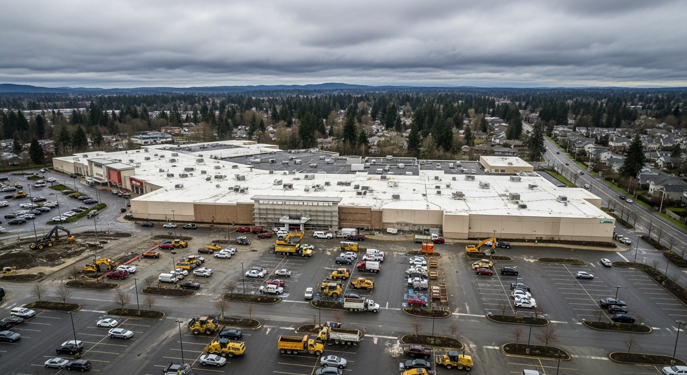
Author: Will Tygart

  • For Casino Road Residents: What Community Transit’s .35M Goodwill Purchase Means for Your Neighborhood

    For Casino Road Residents: What Community Transit’s .35M Goodwill Purchase Means for Your Neighborhood

    For you as a Casino Road resident: Community Transit’s $25.35 million purchase of the Goodwill outlet at 2208 W. Casino Road means a major public agency has locked in a 7.55-acre anchor in your neighborhood — before the light rail redevelopment pressure arrives. Here is what that means for your daily life, your housing stability, and your community’s future.

    Your Neighborhood Just Got a New Public Anchor

    For residents of Casino Road, Community Transit’s February 2026 acquisition is the most significant land transaction on the corridor in years. The 7.55 acres at 2208 W. Casino Road — the Goodwill Bins site — is now owned by a public agency, not a private developer. That distinction matters more than it might appear.

    Casino Road has two Sound Transit light rail stations planned as part of the Everett Link Extension. When light rail comes to a corridor, land values rise. In Seattle’s Rainier Valley and along the First Hill corridor, the combination of light rail investment and speculative land buying displaced thousands of residents and longtime businesses before communities could respond. Casino Road is watching those dynamics develop in slow motion — and Community Transit just placed 7.55 acres of the corridor in public hands before the speculative wave crests.

    The Goodwill Bins Stay Open — For Now

    The practical answer most Casino Road residents want first: the Bins are staying. Evergreen Goodwill signed a three-year leaseback with Community Transit, meaning the bulk-pricing outlet store at 2208 W. Casino Road continues operating through approximately early 2029. If you shop there regularly — or know someone who depends on it for affordable goods — no immediate change is required.

    After the leaseback ends, Community Transit will use the site for operational purposes: vehicle storage, maintenance, and administrative functions to support its growing bus network. What that means for foot traffic on that block will depend on how the agency designs its buildout. Residents near the site should watch for Community Transit public planning meetings as the leaseback end date approaches.

    How This Connects to the Everett Transit Merger

    Casino Road residents who rely on bus service should know that Everett Transit is being consolidated into Community Transit. The state legislature’s SB 5801 sets the framework; Everett City Council voted April 29 to approve a formal letter to Sound Transit demanding full delivery of the Everett Link Extension as a paired commitment. The merged transit system — combining Everett Transit’s 22 routes and 115,000 daily riders with Community Transit’s regional network — will use the expanded Casino Road campus as part of its operational foundation.

    For residents who depend on the Route 7 (Paine Field / Casino Road corridor) and other routes serving south Everett, the consolidation is designed to improve frequency and extend coverage. Community Transit’s Journey 2050 plan targets 30 million annual riders — more than triple current ridership — which requires both the Casino Road land and a fully funded light rail extension to work.

    What to Watch as a Casino Road Resident

    The three-year leaseback window (through roughly 2029) is the community engagement window. This is when Community Transit will be planning how it uses the property long-term. If community organizations, including Connect Casino Road, push for a mixed-use development that includes affordable housing or community space, that conversation needs to happen before the agency finalizes its operational buildout plans. Public agencies can — and sometimes do — include community benefit components in transit-adjacent development when community pressure is organized and early.

    The NR-MHC zoning effort — Everett’s proposal to protect seven mobile home parks in the Casino Road area from conversion to market-rate housing — is a parallel protection mechanism. The Community Transit acquisition and the NR-MHC zone together represent two distinct forms of displacement protection arriving in the corridor at the same time. Neither is sufficient alone; together they create meaningful stability in a neighborhood under significant long-term pressure.

    Frequently Asked Questions for Casino Road Residents

    Is the Goodwill Bins closing on Casino Road?

    No — not yet. Community Transit signed a three-year leaseback with Evergreen Goodwill, keeping the Bins open at 2208 W. Casino Road through approximately early 2029. After that, Community Transit will use the site for bus operations.

    Will my bus routes change because of this?

    Not immediately. The Casino Road campus acquisition is an operational expansion to support long-term ridership growth and the Everett Transit consolidation. Route changes will come through the consolidation planning process, not directly from this land purchase.

    Does this protect Casino Road from gentrification?

    It provides one form of protection: 7.55 acres of the corridor is now in public ownership and cannot be sold to a private developer without a public process. It does not, by itself, prevent rising rents or displacement pressure on the surrounding blocks. The NR-MHC zone and Connect Casino Road coalition are the primary community-led mechanisms addressing those pressures.

    How does this relate to the light rail stations planned for Casino Road?

    Two Sound Transit light rail stations are planned for the Casino Road corridor under the Everett Link Extension. Light rail typically accelerates land value increases and displacement pressure in station areas. Community Transit’s acquisition puts a large public parcel in the corridor before those dynamics peak — a meaningful protection even if it is not explicitly framed that way.

    Can I get involved in planning how Community Transit uses this site?

    Yes. Community Transit holds public board meetings and planning processes for major facility projects. Connect Casino Road and the associated neighborhood organizations are the most direct channel for organized community input. The three-year leaseback gives residents roughly a 2029 window before the site transitions to full operational use.

    Related Exploring Everett coverage: Community Transit Just Bought the Goodwill Bins on Casino Road | The Complete Guide to the .35M Acquisition | Everett Transit Consolidation Complete Guide

  • Community Transit Just Bought the Goodwill Bins on Casino Road: A Complete Guide to What the $25.35M Acquisition Means for Everett

    Community Transit Just Bought the Goodwill Bins on Casino Road: A Complete Guide to What the $25.35M Acquisition Means for Everett

    Quick Answer: Community Transit’s board unanimously approved the $25.35 million purchase of the 7.55-acre Goodwill outlet property at 2208 W. Casino Road in February 2026 — the largest single land acquisition in the agency’s 40-year history. The “Bins” stay open under a three-year leaseback. For Casino Road, a corridor already under pressure from two planned Sound Transit light rail stations and rising displacement risk, this deal is more than bus storage: it locks a major public agency into the neighborhood just as the redevelopment clock starts ticking.

    What Just Happened on Casino Road

    In February 2026, Community Transit’s board of directors voted unanimously to purchase the 108,000-square-foot Goodwill outlet complex at 2208 W. Casino Road — the one locals call “the Bins,” where goods are priced by the pound — for $25.35 million. The seller was Evergreen Goodwill of Northwest Washington. A three-year leaseback means the Bins stay open while Community Transit prepares the site for long-term operational use.

    The property sits directly adjacent to Community Transit’s existing Cascade administration building, making it a contiguous expansion of the agency’s south Everett operational campus. Community Transit’s Journey 2050 Long-Range Plan projects the agency will serve 30 million annual riders by 2050. Current vehicle storage and maintenance capacity will be exhausted well before that target. The Casino Road acquisition addresses the near-term capacity crunch.

    Why Casino Road — and Why Now

    The timing matters. Casino Road is one of the most consequential corridors in Everett’s near-future. Two Sound Transit light rail stations are planned along the corridor as part of the Everett Link Extension — a 16-mile project connecting downtown Everett Station to the regional light rail spine that Snohomish County voters approved in 2016. The planned stations at SW Everett Industrial Center and a second Casino Road-area station will bring transformative transit access to a corridor that today runs largely on surface streets and Community Transit bus routes.

    Light rail station areas historically trigger rapid land value appreciation and displacement pressure on existing residents and businesses. Casino Road’s demographics — a dense, multiethnic, working-class corridor with a high concentration of renters, small businesses, and community organizations — make it especially vulnerable to the kind of transit-driven displacement that has reshaped Rainier Valley and the Beacon Hill corridor in Seattle.

    Community Transit’s acquisition puts 7.55 acres of the corridor in public hands before the displacement dynamics fully accelerate. That’s not stated as the purchase rationale in agency documents — the stated rationale is operational capacity — but the community development implications are real and significant.

    The Property: What Community Transit Actually Bought

    The 108,000-square-foot complex at 2208 W. Casino Road includes a large-format warehouse retail footprint and associated operational space. The Goodwill outlet — distinct from standard Goodwill retail stores — operates as a bulk-pricing clearance operation where items are sorted onto tables and priced by weight. It draws a regional customer base and has operated at this Casino Road location for years.

    Under the three-year leaseback, Evergreen Goodwill continues operating the Bins. Community Transit takes legal ownership but receives lease income while planning its operational buildout. The $25.35 million purchase price reflects the property’s scale and its location in a corridor that is already beginning to command higher land values in anticipation of light rail.

    What This Means for the Casino Road Corridor

    Casino Road is home to roughly 13,000 residents, a dense network of immigrant-owned small businesses, and over two dozen community-serving organizations. The Connect Casino Road initiative — a community-led planning effort — has been working for years to ensure that the transit investment coming to the corridor lifts residents rather than displacing them.

    Community Transit’s land purchase adds a significant public anchor to the corridor. Public agency ownership is among the strongest protections against speculative displacement, since the land cannot be sold to a private developer without a public process. Whether Community Transit eventually co-develops the site with affordable housing, a transit-oriented community hub, or strictly operational facilities will depend on community engagement and agency planning decisions over the next several years.

    The acquisition also reinforces Community Transit’s long-term commitment to south Everett as its operational base — important context for residents and business owners watching the Everett Transit consolidation process unfold. As Everett Transit phases toward integration with Community Transit under SB 5801, the Casino Road campus becomes an even more critical node in the merged system’s service geography.

    The Everett Transit Consolidation Connection

    The Goodwill acquisition lands in the middle of a broader transit restructuring. Everett City Council is moving toward consolidating Everett Transit into Community Transit under state legislation, a process that would dissolve the city’s 100-year-old transit system and transfer 22 routes, 161 workers, and 115,000 riders to Community Transit. That consolidation was the subject of a major Everett Council action in April 2026.

    The Casino Road campus expansion positions Community Transit to absorb that additional operational footprint. More vehicles, more routes, and more maintenance capacity will require more land — and Community Transit just acquired it in the most strategically positioned location it could find: right next to what it already owns, in a corridor that will be transformed by light rail within the decade.

    What Residents and Businesses Should Watch

    The three-year Goodwill leaseback runs through approximately early 2029. That’s the window in which Community Transit will be finalizing plans for the site. Residents and community organizations invested in the future of Casino Road should engage with Community Transit’s public planning process as it develops. The Connect Casino Road coalition and associated organizations are the most direct channel for community voice on how this land ultimately gets used.

    For small businesses along Casino Road, the acquisition signals stability in one sense — a major public employer is investing heavily in the corridor — and uncertainty in another. If the site transitions from retail (the Bins) to operational bus storage and maintenance, the commercial traffic those retail operations generate will shift. Business owners near 2208 W. Casino Road should monitor the leaseback timeline.

    Frequently Asked Questions

    What did Community Transit buy on Casino Road in Everett?

    Community Transit purchased the 7.55-acre Goodwill outlet property at 2208 W. Casino Road for $25.35 million in February 2026. The 108,000-square-foot complex is the largest single acquisition in the agency’s 40-year history. The Goodwill “Bins” store stays open under a three-year leaseback agreement.

    Will the Goodwill Bins on Casino Road close?

    Not immediately. Evergreen Goodwill signed a three-year leaseback with Community Transit, meaning the Bins will continue operating at 2208 W. Casino Road through approximately early 2029. After the leaseback ends, Community Transit will use the site for operational purposes.

    Why did Community Transit buy land on Casino Road?

    Community Transit’s Journey 2050 plan projects the agency will serve 30 million annual riders by 2050 — up sharply from current ridership. Vehicle storage, maintenance, and administrative capacity at the existing Cascade campus will be exhausted before that target. The adjacent Goodwill property expands the campus and positions Community Transit for the Everett Transit consolidation.

    How does this relate to light rail on Casino Road?

    Two Sound Transit light rail stations are planned for the Casino Road corridor as part of the Everett Link Extension. Light rail station areas typically trigger land value increases and displacement pressure. Community Transit’s acquisition puts 7.55 acres in public ownership before those dynamics fully accelerate, providing a stable public anchor in the corridor.

    What is Connect Casino Road and what does this mean for them?

    Connect Casino Road is a community-led planning initiative working to ensure that light rail investment benefits existing Casino Road residents rather than displacing them. Community Transit’s land acquisition creates an opportunity for community engagement around how the site is ultimately developed, particularly if the agency ever considers mixed-use or affordable housing components on the parcel.

    How does the Goodwill acquisition relate to the Everett Transit merger?

    Everett is consolidating its transit system into Community Transit under SB 5801. That merger adds 22 routes, 161 workers, and 115,000 riders to Community Transit’s network. The Casino Road campus expansion gives Community Transit the physical space to absorb that additional operational footprint — more vehicles, more routes, and more maintenance demand.

  • Everett’s Utility Tax Proposal Is Coming Before the City Council in May — Here’s What It Costs, Who It Affects, and How to Weigh In Before the Vote

    Everett’s Utility Tax Proposal Is Coming Before the City Council in May — Here’s What It Costs, Who It Affects, and How to Weigh In Before the Vote

    What this means for you: The City of Everett is moving a proposal to replace its current 6% utility billing charge with a 12% utility tax to the City Council for a formal vote beginning in May 2026. For a typical Everett residential water customer, that’s an estimated increase of about $10.74 per month. The change would affect not just Everett residents, but customers across more than 75% of Snohomish County who rely on Everett’s water, sewer, and stormwater system. If approved, the new rate takes effect as early as July 1, 2026.
    This is the part of Everett’s budget conversation that doesn’t make the headlines the way a stadium vote or a light rail letter does — but it shows up on your water bill. The City of Everett is preparing to bring a utility tax proposal before the City Council this month, a move that would effectively double the charge applied to residents’ and businesses’ water, sewer, and stormwater bills. The proposal has been in development since at least March 2026, when the council received an informational briefing. Now, with legislation expected to go before the council beginning in May, the public comment window is officially open — and closes once the council acts.

    What’s Actually Being Proposed

    Since 1983, Everett has collected a 6% Payment in Lieu of Taxes — often called PILOT — on utility bills. A PILOT is essentially a transfer from a city-owned utility to the city’s general fund, a substitute for the property taxes a private utility would pay. It’s built into your water bill already; you’ve been paying it for decades, even if you didn’t know the line item’s name. What Everett is now considering is replacing that 6% PILOT with a 12% utility tax — doubling the rate. The change would generate approximately $7.5 million per year in additional revenue for the city’s general fund. The general fund pays for the city services residents use every day: parks, libraries, streets, and public safety. Everett, like most Washington cities, faces a structural constraint on how much its property tax revenue can grow under Initiative 747 — capped at 1% per year, regardless of inflation. That constraint is the underlying driver of the $14 million projected budget deficit the city is working to close by 2027.

    What It Costs

    For a typical residential customer, the estimated monthly increase is $10.74 per month, or roughly $129 per year. That’s the city’s own estimate from the March 2026 council briefing. The increase applies to water, sewer, and stormwater charges combined, since the utility tax rate is applied across all three services. Business customers and other large users of Everett’s water system would see increases scaled to their consumption. Everett provides water, sewer, and stormwater services not just to city residents but to customers across a wide regional footprint — more than 75% of Snohomish County. That means the financial impact extends well beyond Everett city limits. A family in parts of Mukilteo, Snohomish, or unincorporated Snohomish County who receives their water from Everett Utilities could see the same rate change reflected on their bill if the council approves it.

    Is This Unusual?

    The city’s own research says no — most neighboring cities already use a utility tax at comparable or higher rates. Everett’s current 6% PILOT has been in place since 1983, making it one of the lower rates in the region. The council briefing included a comparison of other jurisdictions’ utility tax rates that supports this framing. That said, calling it a “utility tax” instead of a “PILOT” is more than semantic. PILOTs are internal transfers; utility taxes are charges on the consumer. The shift changes how the revenue is classified — and potentially how it’s understood by the public.

    The $14 Million Context

    The utility tax proposal doesn’t exist in isolation. It’s one of four major revenue levers the city is exploring to close a projected $14 million general fund deficit by 2027:
    • Regional fire authority (RFA) — Merging Everett Fire with other agencies in a regional structure, moving fire costs off the city’s general fund.
    • Sno-Isle Library regionalization — Shifting library costs to a regional taxing district.
    • Another levy lid lift — Going back to voters to raise property taxes above the I-747 cap.
    • Mariner annexation — Bringing the roughly 21,000-resident Mariner neighborhood into Everett’s tax base, adding revenue without raising rates on existing residents.
    Three of those four require a public vote. The utility tax does not — it is a council decision. That makes it the most direct and immediate tool available to the city without going to the ballot, and it explains why it’s moving to a council vote this spring rather than waiting for an August or November election. That same August ballot already carries the EMS levy lid lift, which asks voters to restore the EMS property tax rate from $0.36 to $0.50 per $1,000 of assessed value to maintain roughly 78 firefighter-paramedic positions at Everett Fire Department.

    What the Council Process Looks Like

    The council has been briefed. The legislation is now being drafted for formal consideration. Once introduced, the typical council process includes a first reading, an opportunity for public comment, and a vote — which could happen within weeks of the bill’s formal introduction. The council meets on Wednesdays. Under its standard schedule, most meetings begin at 6:30 p.m. at Everett City Hall; the fourth and fifth Wednesdays of the month begin at 12:30 p.m. Public comment is accepted at all council meetings, either in person or virtually through the city’s online registration system. The city has also signaled it is considering expanding its utility assistance program for low-income residents to help offset the cost increase. Specific eligibility details have not been publicly released as of this writing.

    Frequently Asked Questions

    Does this affect residents outside Everett city limits?
    Yes. Everett provides water, sewer, and stormwater services to customers across more than 75% of Snohomish County. Any customer whose utility service is billed through Everett Utilities could see the rate change reflected on their bill. Why can’t the city just cut spending instead?
    Washington’s I-747 caps property tax growth at 1% per year regardless of inflation or service cost increases. That constraint — not spending choices alone — is the primary driver of the projected deficit. What is a PILOT, and how is it different from a utility tax?
    A Payment in Lieu of Taxes (PILOT) is an internal transfer from a city-owned utility to the general fund, functioning as a substitute for property taxes. A utility tax is a charge assessed on the consumer. Both produce revenue for the general fund, but the legal structure and how it appears on bills differ. Is 12% high compared to other cities?
    According to the city’s own comparison of nearby jurisdictions, most Washington cities use utility taxes at rates comparable to or higher than 12%. Everett’s current 6% PILOT is on the lower end of regional practice. What does the money pay for?
    The general fund covers parks, libraries, streets, and public safety — the core services Everett residents interact with daily. Will there be low-income assistance?
    The city has indicated it is considering expanding utility assistance for low-income households as part of the proposal, but specific eligibility details have not been announced. Can the council vote on this without a public vote?
    Yes. A utility tax is a council decision and does not require a ballot measure. This distinguishes it from three of the four other revenue options under consideration (levy lid lift, RFA formation, and library regionalization), all of which require voter approval.

    What To Do Next

    Comment now — before the vote: Once the council votes, the public comment window closes. Submit written comments by email to council@everettwa.gov or attend a city council meeting in person or virtually. The virtual public comment registration form is at everettwa.gov. Attend a council meeting: The Everett City Council meets Wednesdays at 6:30 p.m. (or 12:30 p.m. on the 4th and 5th Wednesdays) at Everett City Hall, 3002 Wetmore Ave. Public comment is taken at the start of each regular meeting. Review the March briefing materials: The council received a full briefing on March 18, 2026. The presentation PDF and video recording are available at everettwa.gov/council. The presentation includes the comparison of other jurisdictions’ rates and the utility service area map. Check your utility provider: If you live outside Everett city limits, verify whether your water service is provided by Everett Utilities — and therefore whether this rate change would affect your bill. Contact your council member: All nine Everett City Council members represent the city at large. Contact information is available at everettwa.gov/council.

    Related coverage: Everett’s $14 Million Budget Gap Is Back — and Regionalizing Fire and Libraries Is on the Table | Mayor Franklin’s 2026 State of the City: Five Priorities Now Shaping Everett | Everett EMS Levy Goes to August 2026 Ballot

  • Everett City Council Sends Sound Transit a Message: Deliver Our Light Rail or Explain Why Not

    Everett City Council Sends Sound Transit a Message: Deliver Our Light Rail or Explain Why Not

    What this means for you: The Everett City Council voted unanimously on April 29 to formally demand that Sound Transit complete the full 16-mile Everett Link Extension — all the way to downtown Everett Station, not just to the SW Everett Industrial Center. The board votes on a revised system plan by June 30. Everett residents have until May 1 to weigh in directly via Sound Transit’s public survey.

    The Everett City Council isn’t waiting to find out what happens to their light rail line. On April 29, the council voted unanimously to sign a formal letter to the Sound Transit Board of Directors, making a clear, documented demand: complete the Everett Link Extension in full and on schedule, and don’t solve Sound Transit’s $34.5 billion budget shortfall by shortchanging Snohomish County.

    The letter, brought forward by City Council Vice President Paula Rhyne, is both a political signal and a public record — arriving as Sound Transit prepares to vote this summer on a revised ST3 System Plan that could reshape the light rail spine that Snohomish County voters have been funding since 2016.

    Why the Council Felt the Need to Act Now

    Sound Transit is navigating a serious financial crisis. The agency faces a projected $34.5 billion shortfall across its light rail extension portfolio, driven by inflation, rising construction costs, tariffs, labor shortages, supply chain disruptions, and higher land acquisition costs. The board is evaluating three broad “approaches” — called the Enterprise Initiative — for closing that gap before its June 30 deadline.

    Two of the three approaches would fund full completion of the 16-mile Everett Link line, running from Lynnwood through the Paine Field area to downtown Everett Station. The third approach would phase the extension, building only to the SW Everett Industrial Center — leaving downtown Everett without a direct connection.

    “The intent of the letter is to remind the board that Everett is expecting the completion of the Everett Link Extension, and that the Everett Link Extension is not the route segment that’s the biggest problem for cost overruns, so cutting our promised route should not be part of the solution,” Rhyne said at the council’s April 22 meeting.

    What the Letter Actually Says

    The council’s approved letter frames the Everett extension as the most cost-effective segment in the entire ST3 package — and uses Sound Transit’s own numbers to make the argument.

    “The Everett Link Extension is the most cost-effective and impactful light rail segment under consideration,” the letter reads. “The cost increases are dramatically lower than other segments due to the extensive and intentional use of existing rights of way, the major portions of track alignment that can be run at-grade, and substantially lower land acquisition costs.”

    For context: some ST3 projects have nearly doubled in expected costs compared to original estimates. The Everett Link Extension’s costs have increased by only about five to ten percent — a fraction of the overruns plaguing the West Seattle and Ballard extensions in North and South King County. Sound Transit staff have previously said there is a high likelihood of keeping the Everett segment affordable through targeted design changes, while preserving all six planned stations.

    The letter also invokes the principle of subarea equity — the foundational policy that Snohomish County’s tax dollars go toward Snohomish County’s projects. Everett residents have been paying the Sound Transit property tax and sales tax levy since 2016. The letter argues that redirecting those funds or shortchanging Snohomish County to cover King County overruns would violate both the letter and spirit of that commitment.

    “Maintaining the commitment to Everett voters, who have been paying into the system for decades, is essential to preserving public trust and upholding Sound Transit’s commitment to subarea equity,” the letter states.

    The closing request is direct: “We urge the Board to deliver the Everett Extension in full and on schedule and to address the most significant cost escalation within the segments where they are occurring, rather than shifting impacts to Everett.”

    The Financial Picture: Who Owns the Problem?

    Snohomish County Executive Dave Somers — who chairs the Sound Transit Board and serves as a board member alongside Mayor Cassie Franklin — has been explicit about where the budget crisis is concentrated.

    Somers told a standing-room audience at an April 14 town hall meeting that about 90 percent of the cost overruns are in the North King County and South King County subareas. The Snohomish subarea’s funding, by contrast, is almost fully in place for the Everett extension.

    Sound Transit attributes approximately $30 billion of its total shortfall to the east-west rail extensions to West Seattle and Ballard — not to the Everett spine.

    Both Somers and Mayor Franklin have stated publicly that they favor completing the spine — the line from the Tacoma Dome to Everett Station — before funding other extensions. “It is the spine from Everett to Tacoma that is actually going to connect this region,” Franklin told the April 14 town hall crowd.

    Somers has said he plans to bring forward a chair’s proposal for the updated system plan that is “affordable at the systemwide level and compliant with our subarea equity policies.” The framework is designed to advance projects into construction when financially feasible while building in contingencies for future uncertainty.

    What Happens Next

    The Sound Transit Board is expected to vote on an updated ST3 System Plan no later than June 30, 2026. A May 28 board meeting is on the calendar as a key decision point before that deadline.

    Current plans call for the Everett Link Extension to arrive near Paine Field by 2037, with the downtown Everett Station opening by 2041. Under the third “approach” currently under consideration — the one that would truncate service at SW Everett Industrial Center — those timelines would slip further.

    A draft environmental impact statement examining the extension’s station locations in detail is expected to be released this fall.

    What the Council Letter Does and Doesn’t Do

    The letter is a formal political communication, not a binding vote on Sound Transit’s budget. It goes into the public record and will be included in the materials Sound Transit’s board reviews ahead of its May 28 meeting. Its weight is persuasive, not procedural.

    What gives it teeth is the unanimity. Every member of the Everett City Council signed it, signaling unified institutional pressure from the city that stands to gain or lose the most from the June 30 decision. It also positions Everett alongside Snohomish County — through Somers — and other Snohomish cities whose residents have been paying into the system since 2016.

    Frequently Asked Questions

    What is the Everett Link Extension?
    A 16-mile light rail line planned to run from Lynnwood through the Paine Field area to downtown Everett Station, adding six new stations. Part of the Sound Transit 3 package approved by voters in 2016.

    Why is Sound Transit’s budget in trouble?
    The agency faces a $34.5 billion projected shortfall through 2046, driven by inflation, construction cost increases, tariffs, labor and supply chain issues. Overruns are concentrated in the West Seattle and Ballard extensions in King County.

    How much did the Everett extension’s costs increase?
    By about five to ten percent — significantly less than some other ST3 projects, which have nearly doubled in cost. The Snohomish subarea is almost fully funded for the Everett segment.

    What is the third “approach” Sound Transit is considering?
    It would build the light rail spine only to Fife (not the Tacoma Dome) and only to SW Everett Industrial Center (not downtown Everett Station). Under this scenario, Everett would not get a downtown light rail connection on the current timeline.

    When does Sound Transit make its decision?
    The board is expected to vote on an updated system plan by June 30, 2026. The May 28 board meeting is a key milestone.

    What is subarea equity?
    The policy that each of Sound Transit’s five subareas — Snohomish, East King, North King, South King, and Pierce — funds its own segment with its own tax revenues. The Everett letter argues that cutting Snohomish County’s service to cover King County overruns would violate this principle.

    What did the council vote on specifically?
    To approve and sign a formal letter to the Sound Transit Board urging full completion of the Everett Link Extension. The vote was unanimous. Council Vice President Paula Rhyne brought the letter forward.

    What To Do Next

    Comment directly to Sound Transit: The agency’s public survey on the Enterprise Initiative approaches closes May 1, 2026 — today. Fill it out at soundtransit.org. Survey responses go to the board before its May 28 meeting.

    Attend or watch Sound Transit Board meetings: The board meets from 1:30 to 4 p.m. at the Ruth Fisher Board Room, 401 Jackson St., Seattle. The next meeting is Thursday, May 28. Virtual attendance is available — visit soundtransit.org for Zoom details.

    Send email directly to the board: Email comments can be submitted through Sound Transit’s website or at any board meeting during public comment.

    Contact the council: Public comment is accepted at Everett City Council meetings on Wednesdays at 6:30 p.m. at Everett City Hall, 3002 Wetmore Ave., or virtually at everettwa.gov.

    Related coverage: Everett’s Light Rail Future Comes to a Head: What the June 30 Sound Transit Vote Means | The June 30 Sound Transit Vote and Everett’s Light Rail Future: A Complete 2026 Guide | Everett City Council Will Decide Whether to End Everett Transit

  • Mason County Business Owner’s Guide: PUD 3 Gigabit Fiber for Business and the Olympic Highway Parking Decision

    Mason County Business Owner’s Guide: PUD 3 Gigabit Fiber for Business and the Olympic Highway Parking Decision

    Two infrastructure projects moving through Mason County in 2026 have direct implications for local businesses. The completion of PUD 3’s Three Fingers Fiber Project means that businesses in the Grapeview area that previously operated without reliable broadband now have access to symmetrical gigabit fiber — a connectivity baseline that changes what’s operationally possible. And for businesses operating on or near Olympic Highway North in Shelton, the city’s $6 million road reconstruction project means a design decision about parking and traffic flow is coming, and the window to influence it is open right now.

    What Gigabit Fiber Means for Mason County Businesses

    The Three Fingers Fiber Project completion isn’t just about residential internet. Businesses in the Three Fingers area of Grapeview — whether retail, service-based, agricultural, or home-based — are now on the same fiber network that urban businesses have built their operations around. PUD 3’s open-access gigabit fiber delivers symmetrical 1,000/1,000 Mbps speeds for approximately $85 per month. Symmetrical upload speed is the detail that matters most for business use: cloud backups, video conferencing, point-of-sale systems, and file transfers all depend on upload, not just download.

    The open-access model gives Mason County businesses something rare: genuine provider competition on a single physical network. PUD 3 owns the fiber infrastructure; multiple retail ISPs compete over it. Businesses can compare service-level agreements, support quality, and pricing between providers — and switch if a better option emerges — without any new wiring or construction. For businesses that have been locked into a single slow provider by geography, this changes the economics of operating from rural Mason County.

    Businesses in Three Fingers that haven’t yet applied for service can reach PUD 3’s Telecom Team at pud3.org. An Engineering Designer will assess the specific construction needed to reach your location.

    Cloquallum Businesses: Fee Waiver Expires May 31

    If your business is in the Cloquallum Communities area — PUD 3’s next active fiberhood — an application fee waiver is in effect through May 31, 2026. After that date, the standard application fee applies. For businesses evaluating the cost of getting fiber established, applying before the deadline is a straightforward way to reduce the upfront expense. Visit pud3.org for current program details.

    Olympic Highway North: What Business Owners Need to Know Now

    The City of Shelton is in the process of selecting a design for the reconstruction of Olympic Highway North, the stretch from C Street to Wallace Kneeland Boulevard. The road last saw pavement in 1989 and the city has secured up to $6 million in funding — including a $3.7 million Washington State Transportation Improvement Board grant — to rebuild it from the ground up. That TIB grant requires bike lanes in the final design. The question is how those bike lanes are configured, and what that means for on-street parking.

    Consultant Transpo Group has developed four design options. For businesses along the corridor, the core variable is customer parking access:

    • Option 1: Parking on both sides retained; traditional painted bike lanes
    • Option 2 (city staff recommendation): Parking on one side; buffered bike lanes that physically separate cyclists from vehicle traffic
    • Option 4: All on-street parking removed; businesses would rely on on-site or side-street parking

    City staff recommend Option 2, citing the balance between safety, parking retention, and the TIB grant requirements. For businesses whose customers depend on on-street parking — retail, food service, personal services — the difference between Option 1 and Option 4 is material. Construction isn’t until summer 2027, but the design is being locked in this winter.

    If you operate a business on or near Olympic Highway North between C Street and Wallace Kneeland Boulevard, attending a city public comment process or submitting input online at sheltonwa.gov is the most direct way to influence the outcome. Once Transpo Group finalizes the design this winter, the configuration is set.

    For more on what PUD 3 fiber means for Mason County businesses, see What PUD 3’s Gigabit Fiber Means for Mason County Business Owners in 2026. Full infrastructure context at Mason County Infrastructure Update — May 2026.

    Frequently Asked Questions

    How does PUD 3’s open-access fiber network benefit Mason County businesses?

    PUD 3 owns the fiber infrastructure and multiple retail ISPs compete to deliver service over it, giving businesses genuine provider choice without requiring new wiring. Businesses pay approximately $85/month for symmetrical 1,000/1,000 Mbps gigabit service — with matching upload and download speeds critical for cloud operations, video conferencing, and large file transfers.

    My business is in Three Fingers — what’s the process to get fiber?

    Contact PUD 3’s Telecom Team at pud3.org. An Engineering Designer will assess what construction is needed to reach your specific location and walk through next steps. The Three Fingers project is now complete, so connections are being processed for all businesses that have applied.

    How will Olympic Highway North construction affect my business access in 2027?

    Construction is planned for summer 2027. Specific traffic management and temporary access plans will be set by the contractor selected in spring 2027. The bigger near-term decision is the design: which option is chosen determines whether on-street parking survives. Businesses should submit input on the design options at sheltonwa.gov before winter 2026, when the design locks in.

    What is the TIB grant requirement for bike lanes on Olympic Highway North?

    The $3.7 million Washington State Transportation Improvement Board grant awarded to Shelton for the Olympic Highway North project requires that the final design include dedicated bicycle lanes. This requirement is non-negotiable — it’s a condition of the funding. All four design options presented by Transpo Group include bike lanes in some form; the debate is about configuration and how much parking each option preserves.

  • Mason County Property Owner’s Guide: PUD 3 Fiber Completion, Property Values, and the Olympic Highway Parking Question

    Mason County Property Owner’s Guide: PUD 3 Fiber Completion, Property Values, and the Olympic Highway Parking Question

    Two infrastructure decisions are moving through Mason County right now that property owners should be tracking closely. The completion of PUD 3’s Three Fingers Fiber Project brings gigabit internet connectivity to Grapeview parcels that previously had limited broadband access — a change with measurable implications for rural property values. Meanwhile, Shelton’s planned $6 million reconstruction of Olympic Highway North is entering the design phase with a question that matters directly to commercial and residential property owners along the corridor: how much on-street parking survives the rebuild?

    Fiber Internet and Property Values in Rural Mason County

    The connection between rural broadband access and property values is well-documented. Properties in previously unserved areas that gain access to high-speed internet — particularly fiber — tend to see measurable increases in assessed and market value, driven by expanded buyer pools: remote workers, retirees, and small business operators who require reliable connectivity now consider properties they would have previously passed over.

    For property owners in the Three Fingers area of Grapeview, PUD 3’s April 2026 completion of the Three Fingers Fiber Project represents exactly that kind of step-change. More than 250 homes and businesses are now connected to PUD 3’s open-access gigabit network — the same symmetrical 1,000/1,000 Mbps service available in Mason County’s more developed areas. For parcels that were previously off the broadband map, this changes the calculus for potential buyers evaluating rural Mason County real estate.

    If you own property in Three Fingers and haven’t yet applied for a connection, the process runs through PUD 3’s Telecom Team at pud3.org. An Engineering Designer will assess what drop construction is needed to reach your parcel specifically. A connected property is a more marketable property.

    Cloquallum: Apply Before May 31

    If your property is in the adjacent Cloquallum Communities area, PUD 3 has extended a fee waiver for new fiber applications through May 31, 2026. That deadline is approaching. Owners of Cloquallum parcels — whether primary residences, rental properties, or undeveloped land — should weigh whether getting fiber service established before the waiver expires makes sense for their specific situation. Visit pud3.org for current terms.

    Olympic Highway North: The Parking Question for Property Owners

    Shelton’s $6 million reconstruction of Olympic Highway North — the corridor from C Street to Wallace Kneeland Boulevard — is in the design phase, and the core tension for commercial property owners along the route is parking. The road hasn’t been paved since 1989, and the rebuild is funded in part by a $3.7 million grant from the Washington State Transportation Improvement Board that requires dedicated bicycle lanes in the final design. That grant condition is non-negotiable.

    Consultant Transpo Group has prepared four design options, each with a different approach to the bike lane requirement. The critical variable for property owners is on-street parking:

    • Option 1: Retains parking on both sides of the road; traditional (painted) bike lanes
    • Option 2 (city staff recommendation): Retains parking on one side; buffered bike lanes separating cyclists from vehicles
    • Option 4: Removes all on-street parking; relies on on-site and side-street parking for nearby businesses

    City staff recommend Option 2 for its balance between safety and parking retention, and because it meets the TIB grant funding requirements. Option 4, which eliminates all on-street parking, could significantly affect commercial properties along the corridor whose customers rely on street parking. If you own property or operate a business on Olympic Highway North between C Street and Wallace Kneeland Boulevard, the design selection process happening now is the moment to engage.

    Transpo Group will finalize the design this winter. The project goes to bid in spring 2027 and construction is slated for summer 2027. Provide input now at sheltonwa.gov — once the design is locked, the parking configuration is set.

    For the full infrastructure update, see Mason County Infrastructure Update — May 2026. For Mason County real estate context, see Mason County Real Estate: Prices, Trends and Neighborhoods.

    Frequently Asked Questions

    Does fiber internet increase rural property values in Mason County?

    Research consistently shows that rural properties gaining access to fiber broadband tend to see increased market appeal and value, particularly as the remote-work buyer pool has expanded. Properties in the Three Fingers area of Grapeview now have access to PUD 3’s gigabit fiber network following the April 2026 project completion — a connectivity upgrade that changes how potential buyers evaluate those parcels.

    If I own property in Three Fingers, what do I need to do to get fiber connected?

    Contact PUD 3’s Telecom Team at pud3.org. An Engineering Designer will review your specific parcel’s connection requirements and walk through next steps. If you haven’t applied yet, do so now — the project is complete and connections are being processed for applicants.

    Which Olympic Highway North design option keeps the most parking?

    Option 1 retains parking on both sides of the road while adding traditional bike lanes. Option 2 (the city staff recommendation) retains parking on one side with buffered bike lanes. Option 4 eliminates all on-street parking. The design won’t be finalized until winter 2026 — property owners along the corridor should submit input now at sheltonwa.gov.

    When does Olympic Highway North construction start, and how long will it affect access?

    Construction is scheduled to begin in summer 2027 following a spring 2027 bidding process. Specific traffic management and access plans will be determined by the selected contractor. Property owners along the C Street to Wallace Kneeland Boulevard corridor should monitor sheltonwa.gov for contractor updates as the 2027 construction date approaches.

  • New to North Mason? What the Tahuya River Preserve Tells You About Hood Canal — and This Community

    New to North Mason? What the Tahuya River Preserve Tells You About Hood Canal — and This Community

    If you’ve recently moved to North Mason — or you’re considering it — one of the first things you’ll notice is that people here talk about the river. Not metaphorically. The Tahuya River, which drains eastern Mason County and empties into Hood Canal just east of Belfair, is part of the local identity in a way that takes newcomers a minute to fully absorb. This week, 190 acres along the lower Tahuya became permanently protected conservation land. Here’s what that means, and why it matters to you.

    What Is the Tahuya River?

    The Tahuya River rises in the Tahuya State Forest and flows generally west and north through the Tahuya Peninsula before joining Hood Canal south of Belfair. The lower river corridor — the stretch that Great Peninsula Conservancy has been protecting — runs through floodplain forest and wetlands in eastern Mason County, a landscape of big cottonwoods, alder, and towering Douglas firs that overlook the valley.

    Each fall, bear tracks and salmon carcasses appear on the lower Tahuya’s banks. That’s not folklore — it’s ecology. Hood Canal summer chum and Chinook salmon both return to the Tahuya to spawn. Both species are listed under the federal Endangered Species Act. The summer chum were actually considered locally extinct here in the late 1990s before a restoration effort by the Hood Canal Salmon Enhancement Group (HCSEG) rebuilt the run using donor fish from the Union River. Since 2006, 200 to 1,000 summer chum return to the Tahuya every year on their own.

    Who Is HCSEG and Where Are They?

    The Hood Canal Salmon Enhancement Group is headquartered right in Belfair, at 600 NE Roessel Road — the same address as the Salmon Center, where the Hood Canal Salmon Run 5K is held each June. HCSEG has been doing salmon research, habitat restoration, and community education in the Hood Canal watershed since the 1990s. They run rotary screw traps on the Tahuya, Dewatto, and Little Quilcene Rivers each spring to count juvenile salmon — it’s one of the primary data sets used to assess whether salmon populations are recovering.

    If you’re new to North Mason and want a fast, credible education in why Hood Canal is the way it is — environmentally, ecologically, culturally — HCSEG is the organization to know. They welcome volunteers, host community events, and their staff are genuinely approachable. Phone: (360) 275-9284. Website: pnwsalmoncenter.org.

    What Is the Tahuya River Preserve?

    Great Peninsula Conservancy assembled the preserve in stages starting in July 2023: 145 acres acquired with Washington Department of Ecology and state Salmon Recovery Funding Board support, then 38 more acres that December, then two small parcels in 2025. The total is now 190 acres, permanently protecting roughly 450 feet of Tahuya River mainstem and anchoring a longer-term plan to conserve the lower four miles of the river.

    The land is held by GPC, based at 6536 Kitsap Way in Bremerton. It is not open to the public for recreation — it’s managed as a working conservation site. But its existence changes what is possible along the lower Tahuya for decades to come.

    What’s Actually Happening Next: The Gabion Wall

    The most concrete near-term project is the planned removal of a Gabion wall from the Tahuya River corridor. A Gabion wall is a wire-cage rock structure — you’ve probably seen them along highways or near bridges, used for erosion control. They work fine for holding a bank in place, but they disrupt the natural flow dynamics that salmon spawning habitat requires: the shifting gravel beds, the cool deep pools, the wood debris accumulations where juvenile fish shelter and feed.

    GPC and HCSEG are working through permitting and hydrology studies to plan the removal. After the wall comes out, engineered log jam structures may be installed upstream to rebuild the natural channel complexity the river has lost. The project is still in planning phase as of May 2026 — but the land protection that makes it possible is locked in.

    Why This Is Part of What Makes North Mason Different

    A lot of communities talk about caring about their environment. North Mason is one of the few places where you can stand at a boat launch on Hood Canal, watch a salmon jump, and trace that fish’s story back to a specific river, a specific restoration project, and a specific group of people who have been working on it for 30 years — and who are headquartered two miles from the Belfair Fred Meyer.

    The Tahuya River Preserve is part of that story. If you’re going to be here long-term, it’s worth knowing it.

    Also see: Tahuya River Preserve: Full Story | Hood Canal from Belfair: Fishing, Kayaking and Beaches

    Frequently Asked Questions

    What is the Tahuya River and where does it flow?

    The Tahuya River drains the Tahuya Peninsula in Mason County, flowing west and north before emptying into Hood Canal south of Belfair. The lower river corridor runs through floodplain forest in eastern Mason County. The river supports ESA-listed summer chum and Chinook salmon runs.

    What is the Hood Canal Salmon Enhancement Group and how can I get involved?

    HCSEG is a Belfair-based nonprofit that has led salmon research, habitat restoration, and education in the Hood Canal watershed since the 1990s. They welcome volunteers for rotary screw trap operations, restoration plantings, and community events. Find them at 600 NE Roessel Road, Belfair, (360) 275-9284, or pnwsalmoncenter.org.

    Can I visit the Tahuya River Preserve?

    The preserve is not currently open to the public for recreation. It is managed as a conservation area by Great Peninsula Conservancy. The nearby Tahuya State Forest and the lower Hood Canal shoreline offer public outdoor access in the same general area.

    What is a Gabion wall and why is removing it good for salmon?

    A Gabion wall is a wire-cage rock structure used for stream bank stabilization. While effective at holding banks in place, they alter natural stream flow, disrupt the gravel beds salmon use for spawning, and prevent wood debris from moving downstream — wood that creates the deep pools and feeding habitat juvenile salmon depend on. Removal allows the stream to recover more natural dynamics.

    Are salmon actually recovering in Hood Canal?

    Yes. Hood Canal summer chum — which were locally extinct in the Tahuya River in the 1990s — have sustained themselves without supplementation since 2015. NOAA Fisheries has indicated the population may meet ESA delisting criteria, which would be the first successful salmon delisting in U.S. history. The Tahuya River is part of that recovery story.

  • Mason County Resident’s Guide: How to Get PUD 3 Fiber and What the Shelton Road Project Means for You

    Mason County Resident’s Guide: How to Get PUD 3 Fiber and What the Shelton Road Project Means for You

    If you live in the Three Fingers area of Mason County and have been waiting for fiber internet, the wait is officially over. Mason County Public Utility District No. 3 completed its Three Fingers Fiber Project in April 2026, meeting its federal deadline and connecting more than 250 homes and businesses in the Grapeview community to symmetrical gigabit fiber. And if you’re a Shelton resident who drives Olympic Highway North, you should know the city is moving forward — slowly but seriously — on a $6 million reconstruction of the corridor that hasn’t been resurfaced since 1989.

    How to Get Fiber Connected to Your Home in Three Fingers

    If you live in the Three Fingers area and haven’t yet applied for PUD 3 fiber service, the process is straightforward. Contact PUD 3’s Telecom Team at pud3.org and an Engineering Designer will review what construction is needed to reach your specific property and walk you through the next steps.

    Once connected, you choose your own internet service provider — that’s what makes PUD 3’s open-access network different from a traditional cable or DSL provider. PUD 3 owns the fiber cable running to your home, but multiple retail ISPs compete to deliver service over it. You can switch providers without any new wiring being installed. Most customers pay approximately $85 per month for unlimited, symmetrical 1,000/1,000 Mbps (gigabit) internet — speeds that match what urban customers in Seattle or Tacoma pay significantly more for.

    What does gigabit fiber mean day-to-day? Streaming video on multiple devices simultaneously with no buffering. Video calls without freezing or dropped connections. Large file uploads that used to take hours finishing in minutes. For households with remote workers, students doing homework, or anyone who has been frustrated by slow rural internet, the practical difference is significant.

    What About Cloquallum? You Still Have Time

    If you’re in the neighboring Cloquallum Communities area rather than Three Fingers, PUD 3’s next fiberhood is underway. An application fee waiver was extended through May 31, 2026 — but that deadline is close. Residents in Cloquallum should visit pud3.org now to check the current status and apply before the waiver expires.

    What the Olympic Highway North Project Means for Your Commute

    For Shelton residents who use Olympic Highway North to get around — the stretch from C Street to Wallace Kneeland Boulevard — the road project is still years away from breaking ground. Design won’t be finalized until winter 2026, bids won’t go out until spring 2027, and construction is targeted for summer 2027. So the cracked pavement you’re driving on now will be there a while longer.

    What’s being decided right now is what the rebuilt road will look like. The city has four design options on the table from consultant Transpo Group. A $3.7 million grant from the Washington State Transportation Improvement Board requires that dedicated bike lanes be included — that’s not optional. The debate is about how to configure the bike lanes: buffered, traditional, one-sided or two-sided, and how much on-street parking survives in each option.

    City staff are recommending Option 2, which keeps parking on one side of the road and uses buffered (not just painted) bike lanes. If you have an opinion on the design, now is the time to voice it. Visit sheltonwa.gov for the project page and public comment opportunities.

    For more on the broader fiber buildout across Mason County, see When Is Fiber Internet Coming to My Mason County Neighborhood? and the full infrastructure update at Mason County Infrastructure Update — May 2026.

    Frequently Asked Questions

    I live in Three Fingers — how do I sign up for PUD 3 fiber?

    Go to pud3.org and contact PUD 3’s Telecom Team. An Engineering Designer will assess what construction is needed to connect your specific property and walk you through the sign-up process. The Three Fingers project is complete, but individual home connections may still be pending if you haven’t applied yet.

    Can I choose my own internet provider with PUD 3 fiber?

    Yes. PUD 3 operates an open-access fiber network, meaning multiple retail internet service providers compete to deliver service over the same physical fiber cable that PUD 3 owns. You select the ISP you prefer and can switch without any new infrastructure installation. Gigabit service runs approximately $85/month.

    Will Olympic Highway North be closed during construction?

    Construction isn’t expected to begin until summer 2027, so no closures are imminent. When construction does begin, specific lane closure and traffic management plans will be determined by the contractor selected during the spring 2027 bidding process. The City of Shelton will publish project updates at sheltonwa.gov.

    What is the Cloquallum Communities Fiberhood fee waiver?

    PUD 3 extended an application fee waiver through May 31, 2026, for residents in the Cloquallum Communities area — the next fiberhood after Three Fingers. If you live in Cloquallum and want to apply for fiber service with the fee waived, visit pud3.org before May 31.

  • Hood Canal Property Owners: What the Tahuya River Preserve Means for Water Quality, Shellfish, and Your Shoreline

    Hood Canal Property Owners: What the Tahuya River Preserve Means for Water Quality, Shellfish, and Your Shoreline

    If you own property on Hood Canal — tidelands, a waterfront parcel, or even a lot a mile back from the water — the long-term health of the canal directly affects what you own. That’s why the permanent protection of 190 acres along the lower Tahuya River is worth understanding, not just as an environmental story, but as a water-quality and property-value story.

    What the Tahuya River Does to Hood Canal

    The Tahuya River drains eastern Mason County and empties into Hood Canal near Belfair. What happens in that watershed — how much sediment runs off after a rain event, how much nutrient load enters the canal, how warm the water is by July — directly affects conditions in Hood Canal itself.

    Hood Canal is a semi-enclosed fjord. It doesn’t flush as quickly as open Puget Sound. Dissolved oxygen levels, water temperature, and nutrient loading matter here in ways that are measurable and consequential. When those factors tip the wrong direction, shellfish beds close. When they hold steady, the canal supports the ecosystem — and the way of life — that Hood Canal property values are built on.

    Great Peninsula Conservancy’s Tahuya River Preserve permanently protects 190 acres of floodplain forest and wetlands along the lower Tahuya corridor. Floodplain forest is not passive. It filters runoff before it reaches the river, moderates water temperatures through canopy shading, and traps sediment that would otherwise flow downstream and into the canal.

    The Gabion Wall Removal: A Direct Water Quality Improvement

    The most significant near-term project connected to the preserve is the planned removal of a Gabion wall from the Tahuya River corridor. Gabion walls — wire-cage rock structures installed for bank stabilization — alter natural stream flow patterns, trap fine sediment in ways that degrade spawning gravel, and prevent the natural movement of large wood debris downstream.

    When the wall comes out, the river will begin recovering a more natural channel dynamic. Engineers are also evaluating engineered log jam structures upstream to rebuild holding pools and feeding lanes for juvenile salmon. Healthier salmon habitat upstream means more adult salmon returning — and salmon carcasses are one of the primary marine-derived nutrient inputs that forest and riparian systems depend on. It’s a closed loop that connects the mountains to the canal.

    The project is in the permitting and planning phase as of May 2026. No construction timeline has been announced, but the land protection necessary to make it happen is complete.

    What This Means for Shellfish Bed Status on Hood Canal

    If you harvest shellfish from Hood Canal tidelands, or if your property value is tied to an open shellfish beach, you already know that closures happen — and that the reasons are usually tied to water quality upstream. Fecal coliform from stormwater, agricultural runoff, and failing septic systems are the primary drivers of WDFW closure events on Hood Canal.

    Protecting floodplain forest along the Tahuya doesn’t fix septic systems — that’s a different problem. But it does reduce one of the diffuse-source inputs: unfiltered runoff from cleared or developed land adjacent to salmon-bearing streams. Every acre of permanently protected floodplain is one less acre that could be cleared, graded, or made impervious in the future.

    For Hood Canal property owners, the preserve is a long-term investment in the upstream conditions that determine what the canal looks like in 20 years.

    The ESA Connection and What It Means for the Canal

    Hood Canal summer chum salmon may become the first ESA-listed salmon population ever removed from the federal endangered species list. That’s not a distant possibility — NOAA Fisheries has signaled the population meets recovery criteria, with Tahuya River runs holding between 200 and 1,000 fish annually since 2006 without supplementation. If delisting proceeds, it would represent a significant reduction in regulatory burden on Hood Canal development and land use — something that directly affects property owners navigating shoreline development permits.

    The Hood Canal Salmon Enhancement Group monitors juvenile salmon on the Tahuya, Dewatto, and Little Quilcene Rivers each spring from their facility at 600 NE Roessel Road in Belfair, (360) 275-9284. Their data is what drives the federal recovery assessment.

    Also see: Tahuya River Preserve: 190 Acres Permanently Protected — Full Story | Hood Canal Property Owners: What the 2026 Shellfish Rule Changes Mean for Your Beach

    Frequently Asked Questions

    Does the Tahuya River Preserve affect Hood Canal shellfish bed closures?

    Indirectly, yes. Protecting 190 acres of floodplain forest along the Tahuya reduces diffuse stormwater runoff into the river and ultimately into Hood Canal. Shellfish closures are driven by fecal coliform levels, and reducing upstream runoff inputs is one piece of the water quality picture. It won’t fix point-source pollution, but it removes a future risk from the equation.

    How does the Gabion wall removal affect Hood Canal water quality?

    Removing the Gabion wall allows the Tahuya River to recover a more natural channel shape — distributing flow across the floodplain, reducing fine sediment export, and allowing wood debris to move naturally downstream. These changes improve water clarity and temperature downstream, benefiting Hood Canal conditions near the river mouth.

    What is the current ESA status of Hood Canal salmon and what does it mean for property owners?

    Hood Canal summer chum and Chinook salmon are both listed as threatened under the ESA. Hood Canal summer chum may be the first ESA-listed salmon ever delisted — a development that would reduce certain regulatory constraints on Hood Canal shoreline and development activities. Continued habitat restoration, including the Tahuya River work, supports the recovery data driving that potential delisting.

    Who is responsible for salmon restoration on the Tahuya River?

    Great Peninsula Conservancy holds and manages the land. The Hood Canal Salmon Enhancement Group (HCSEG), based at 600 NE Roessel Road in Belfair, leads habitat restoration work, juvenile salmon monitoring, and the Gabion wall removal planning in partnership with GPC.

    Does the preserve affect future development near the Tahuya River?

    Yes. The 190 acres are permanently protected by a conservation easement — they cannot be sold for development, cleared, or subdivided. This is the intended outcome: locking in floodplain function in perpetuity so future land use decisions upstream don’t erode what restoration work achieves downstream.

  • Three Fingers Fiber Complete, Shelton Eyes $6M Olympic Highway Overhaul: Mason County Infrastructure Update May 2026

    Three Fingers Fiber Complete, Shelton Eyes $6M Olympic Highway Overhaul: Mason County Infrastructure Update May 2026

    After five years of engineering, federal permitting, and neighborhood-by-neighborhood construction, Mason County Public Utility District No. 3 has crossed its finish line. The Three Fingers Fiber Project — funded in part by a $2.4 million USDA ReConnect Pilot Program grant — reached its April 2026 federal completion deadline with more than 250 homes and businesses in the Three Fingers area of Grapeview now connected to symmetrical gigabit fiber internet. At the same time, Shelton is taking its first deliberate steps toward the most significant road reconstruction the city has seen in nearly four decades, with a $6 million overhaul of Olympic Highway North moving into the design phase. Both projects represent infrastructure investments that will shape how Mason County residents live, work, and move for a generation.

    Three Fingers Fiber: What the Completion Milestone Means

    The Three Fingers area sits in one of the harder-to-reach pockets of Mason County’s broadband map — a community that until recently had to make do with slow or unreliable connections while the rest of the county moved toward fiber. That changes now.

    PUD 3 was the first utility in Washington state to be awarded a USDA ReConnect Pilot Program grant when it received the $2.4 million award in 2020 to extend high-speed wholesale broadband to the Three Fingers area of Grapeview. Construction of the mainline distribution network was completed ahead of schedule despite early COVID-related delays. Over the final months, PUD 3 crews worked block by block through what the district calls its “Fiberhood” model — connecting individual homes and businesses that had applied for service — to hit the April 2026 federal deadline.

    The completion brings PUD 3’s countywide fiber network to more than 3,000 connected premises across Mason County. The open-access design means residents aren’t locked into a single provider: PUD 3 owns the physical fiber infrastructure while multiple local internet retailers compete to deliver service over it. Customers can choose from providers offering unlimited, symmetrical 1,000/1,000 Mbps gigabit internet, HDTV, and phone service — and switch between them without any new wiring — for approximately $85 per month.

    Residents in Three Fingers who have not yet applied for a connection can contact PUD 3’s Telecom Team at pud3.org. An Engineering Designer will review what construction is needed to reach the home and walk through next steps.

    Cloquallum Communities: The Next Fiberhood

    For residents in the neighboring Cloquallum Communities area, PUD 3’s expansion isn’t finished yet. The Cloquallum Communities Fiberhood is the district’s next active buildout, and an application fee waiver was extended through May 31, 2026, for residents in that service area. Anyone in Cloquallum who has not yet applied should check pud3.org for current terms and timelines before the waiver expires.

    Shelton Eyes $6 Million Overhaul of Olympic Highway North

    On the other end of the county, Shelton is beginning a methodical planning process for the most consequential road project the city has taken on in decades. Olympic Highway North — the stretch running from C Street to Wallace Kneeland Boulevard — was last paved in 1989. After 37 years, the pavement is fractured and deteriorating, and the City of Shelton has secured funding to rebuild it from the ground up.

    The total project cost is estimated at up to $6 million. The largest share of that comes from a $3.7 million grant from the Washington State Transportation Improvement Board — funding that comes with a firm requirement: the final design must include dedicated bicycle lanes. That condition is shaping the conversation among residents and decision-makers about how to balance competing uses on the corridor.

    About 50 residents attended a community meeting at the Shelton Civic Center on March 10 to hear consultant Transpo Group present four design options. Each option addresses the road differently, with varying configurations for travel lanes, on-street parking, and bike lanes.

    City staff have recommended Option 2, which features buffered bike lanes that physically separate cyclists from vehicle traffic, parking retained on one side of the road, and a configuration that meets the TIB grant requirements. The staff recommendation notes that Option 2 “offers the greatest balance of modes within the right of way compared to other options” and that the buffered lanes provide improved safety and comfort for cyclists relative to traditional painted bike lanes.

    Transpo Group is expected to finalize the design this coming winter. The project would then go out for bid in spring 2027, with construction potentially beginning in summer 2027. Residents who want to provide input on the design options can visit sheltonwa.gov for project information and public comment opportunities.

    Two Projects, One Theme

    Taken together, the Three Fingers fiber completion and the Olympic Highway North planning process reflect a county working through the accumulated infrastructure debt of rural communities that grew before modern utility and transportation standards caught up. Fiber internet for Three Fingers closes a connectivity gap that left residents effectively offline in a digital economy. The Olympic Highway reconstruction addresses a road that has outlasted multiple generations of patch repairs. Neither project is flashy. Both are exactly what long-term residents and newcomers alike need from their county and city governments.

    For residents with questions about either project, the contact points are clear: pud3.org for fiber service inquiries, and sheltonwa.gov for Olympic Highway North project updates and public input.

    Related Coverage

    For more context on PUD 3’s broader fiber expansion across Mason County, see Mason County PUD 3 Fiber Internet Is Reaching More Homes in 2026 and When Is Fiber Internet Coming to My Mason County Neighborhood?

    Frequently Asked Questions

    Has the Three Fingers Fiber Project been completed?

    Yes. Mason County PUD 3’s Three Fingers Fiber Project reached its federal April 2026 completion deadline. More than 250 homes and businesses in the Three Fingers area of Grapeview are now connected to PUD 3’s open-access gigabit fiber network. Residents who applied for service and have not yet been connected should contact PUD 3’s Telecom Team at pud3.org.

    What is the USDA ReConnect grant that funded Three Fingers fiber?

    The USDA ReConnect Pilot Program provides federal grants to extend broadband to unserved rural areas. Mason County PUD 3 received a $2.4 million ReConnect grant in 2020 — the first such award to a Washington state utility — specifically to fund the Three Fingers buildout. The grant required the project to be completed by April 2026, a deadline PUD 3 met.

    How much does PUD 3 fiber internet cost in Mason County?

    PUD 3 fiber customers pay approximately $85 per month for unlimited, symmetrical 1,000/1,000 Mbps (gigabit) internet through a retail provider of their choice. Because PUD 3 operates an open-access network — owning the fiber infrastructure while multiple ISPs compete to deliver service over it — customers have a choice of providers and can switch without any new wiring.

    What is the Cloquallum Communities Fiberhood, and can I still apply?

    The Cloquallum Communities Fiberhood is PUD 3’s next active fiber buildout, adjacent to the Three Fingers area. An application fee waiver was extended through May 31, 2026. Residents in the Cloquallum area should visit pud3.org to check current terms and apply before the waiver expires.

    Why does Shelton’s Olympic Highway North project require bike lanes?

    The City of Shelton received a $3.7 million grant from the Washington State Transportation Improvement Board to help fund the Olympic Highway North reconstruction. A condition of that grant is that the final design must include dedicated bicycle lanes. The city is currently evaluating four design options from consultant Transpo Group, all of which incorporate bike lanes in different configurations.

    When will Olympic Highway North construction begin?

    The current project timeline calls for Transpo Group to finalize the design in winter 2026, followed by a bid process in spring 2027 and construction beginning in summer 2027. The road runs from C Street to Wallace Kneeland Boulevard in Shelton and has not been paved since 1989.

    How can I give input on the Olympic Highway North project?

    The City of Shelton is continuing to gather public feedback on the four design options presented by Transpo Group at the March 10 community meeting at Shelton Civic Center. Residents can visit sheltonwa.gov for project information and public comment opportunities as the design process continues through 2026.