Tag: North Dakota

  • Storm Updates: New Mexico–Plains Flood Slight, Dakotas Hail Pulse — Thursday, September 24, 2026 (Morning)

    This is a live Thursday morning snapshot of local storm-type events across the United States as of the morning of Thursday, September 24, 2026. Overnight into this morning, the organized severe corridor from Wednesday’s western Dakotas Marginal Risk did verify on the Local Storm Report board — a brief tornado west of Hettinger and baseball-size hail near South Heart, North Dakota. Convective watches are not currently valid. The Storm Prediction Center 0600 UTC Day 1 Convective Outlook, valid 241200Z–251200Z, carries no categorical severe thunderstorm areas. Isolated stronger storms with hail or gusty winds remain possible late this afternoon and early evening from southeast Arizona and southern New Mexico into the Texas Panhandle and western Oklahoma and Kansas.

    The water desk is still the national headline, not wind. Weather Prediction Center short-range language this morning keeps a Slight Risk of excessive rainfall over portions of New Mexico into the south-central Plains, with a broader Marginal Risk from the Four Corners into the central Plains as leftover tropical moisture and embedded shortwaves keep training cells possible on already wet ground. These are county- and ZIP-scale thunderstorms and flash-flood pulses, not a U.S. mainland hurricane landfall. Restoration exposure today is leftover water in New Mexico and the southern High Plains, isolated hail and wind on the Dakotas just-hit pile, and a Hawaii watch for Tropical Storm Nolo well south of the Big Island.

    Conditions change fast. Verify with the National Weather Service for the specific county or ZIP before you roll.

    What is live this morning

    No Storm Prediction Center convective watches are currently valid. The most recently issued watch on the SPC board is Severe Thunderstorm Watch 674, a Sunday-night eastern Colorado and western Kansas product that expired days ago. Yesterday’s western Dakotas and southern Appalachians Marginal Risk is off the Day 1 map. The 0600 UTC discussion from Guyer and Thornton is plain: organized severe thunderstorms are unlikely today and tonight. The same discussion still flags pockets of moderate destabilization into peak heating across southeast Arizona, southern New Mexico, and the southern High Plains.

    The SPC overview hazard matrix later this morning lists Thursday as a Marginal severe day. Treat that as the later-cycle read against the published 0600 UTC text of “no severe thunderstorm areas forecast.” Either way, this is not a watch morning. Isolated hail or a damaging gust is the ceiling unless a new outlook or mesoscale discussion draws a tighter box this afternoon.

    On the flood side, Wednesday’s Weather Prediction Center Day 1 Moderate Risk over the Texas and Oklahoma Panhandles and central and eastern New Mexico has rolled off the valid window. Thursday language from WPC’s short-range public discussion is a step down: Slight Risk of excessive rainfall over portions of New Mexico into portions of the south-central Plains, Marginal Risk across much of the Four Corners into the central Plains. Soils are still saturated. Rates, not coverage, are the problem if a cell trains.

    Hotspot 1 — New Mexico into the Texas and Oklahoma Panhandles and western Kansas

    This remains the water desk. Overnight, National Weather Service Dodge City issued a Flash Flood Warning for northwestern Grant, southeastern Hamilton, western Kearny, northeastern Morton, and eastern Stanton Counties in southwestern Kansas until 5:00 a.m. CDT. Radar-indicated totals of 2 to 3 inches were already on the ground at issuance, with another 1 to 2 inches possible. That warning is off the clock this morning. It is the signature of the same moisture plume that spent midweek over New Mexico.

    WPC still expects scattered showers and thunderstorms Thursday as large-scale forcing weakens but instability and embedded shortwave energy remain. Portions of New Mexico and Texas stay sensitive because of the multi-day rain. Localized 1-inch-per-hour rates on burn scars, arroyos, urban streets, and low water crossings are the first failures. A separate, lower-coverage pulse is possible in southeast Arizona under the same southwesterly mid-level flow.

    Restoration read: extraction and drying on buildings that took water Tuesday and Wednesday, plus a new poor-drainage ticket if a cell parks on a ZIP that already failed. Do not treat the whole Moderate-Risk footprint from yesterday as still live. Staff the county that still has a warning, not the outline from Wednesday afternoon.

    Hotspot 2 — Western North Dakota just-hit pile

    Wednesday afternoon’s western Dakotas Marginal Risk produced the overnight LSR pile. Preliminary Storm Prediction Center reports for the 1200 UTC September 23 through 1159 UTC September 24 window include:

    • A brief tornado around 2236 UTC about 3 miles south-southwest of Bucyrus in Adams County, North Dakota, based on social-media video and radar, west of Hettinger. NWS Bismarck logged the location as approximate.
    • Quarter-size hail (1.00 inch) at New England, Hettinger County, at 2307 UTC.
    • Half-dollar hail (1.25 inches) about 3 miles southeast of Belfield, Stark County, at 2340 UTC.
    • Baseball-size hail (2.75 inches) about 2 miles southwest of South Heart, Stark County, at 2345 UTC.

    Those are official preliminary LSRs, not social rumor. Hail that size breaks windows, dents siding, and wrecks HVAC fins. The tornado report is a one-minute touchdown, not a long-track event. Restoration work there is already a survey-and-tarp job, not a new watch.

    Hotspot 3 — Southern High Plains scatter plus leftover wind reports

    SPC’s Day 1 discussion leaves the door open for a few stronger, locally severe storms late this afternoon and early evening from southeast Arizona and southern New Mexico into the Texas Panhandle and western Oklahoma and Kansas. That is isolated hail and gusty outflow, not a Slight Risk corridor. Yesterday’s board also carries a 58 mph thunderstorm gust 4 miles southeast of Frederick in Tillman County, Oklahoma, at 2158 UTC, and a tree down in Van Wert, Polk County, Georgia, at 2000 UTC. Those are scatter, not a line.

    Farther east, an amplifying coastal low off the Mid-Atlantic and New England is a marine and coastal-flood story, not a convective watch. WPC flags coastal flooding, rip currents, and heavy rain along the East Coast into the weekend. That is a different desk from the New Mexico flood pulse.

    Tropical — Nolo south of Hawaii, not a mainland landfall

    Central Pacific Hurricane Center is issuing advisories on Tropical Storm Nolo. As of 2:00 a.m. HST Thursday, Nolo was about 285 miles south of South Point, Hawaii, and about 460 miles south-southeast of Honolulu, stationary, with maximum sustained winds near 50 mph and a minimum pressure of 999 mb. Official language: Nolo is forecast to intensify into a hurricane late today and could become a major hurricane by the weekend. That is a Hawaii County and offshore-waters problem, not a Gulf or East Coast landfall. Hurricane Polo and Hurricane Odalys remain in the eastern Pacific off Mexico. Tropical Storm Fay is in the open Atlantic well west-southwest of the Azores and is not a U.S. land threat.

    Just hit

    Wednesday’s live desk was still water over central and eastern New Mexico, with SPC trimmed to a western Dakotas Marginal. That Dakotas box verified overnight on hail and a brief tornado. The New Mexico Moderate flood risk has stepped down to Slight into the south-central Plains. Southwestern Kansas took a late-night flash-flood warning that expired at 5:00 a.m. CDT. No new convective watch fired overnight. Watch 674 is not today’s product.

    Pulse table

    RegionMain threatsSPC / NWS / WPC levelStatus this morning
    NM into TX/OK Panhandles and western KSFlash flood, training heavy rainWPC Slight excessive rainfallLive flood overlay; KS FFW expired 5 a.m. CDT
    SE AZ / southern NM / southern High PlainsIsolated hail, gusty wind, heavy rainSPC 0600 UTC: no categorical area; isolated stronger storms possibleAfternoon–evening scatter
    Western ND (Hettinger / Stark)Hail damage, brief tornadoYesterday Marginal; LSRs inJust-hit / survey
    Four Corners to central PlainsIsolated heavy rainWPC Marginal excessive rainfallDiurnal cells
    East Coast marine / New England coastCoastal flood, wind, heavy rainWPC / OPC coastal lowNot a convective watch
    Hawaii — NoloTropical storm to hurricane risk south of the islandsCPHC TS Nolo, 50 mphWatch Hawaii products, not mainland
    Atlantic / Gulf vs. U.S. mainlandNo landfalling hurricaneQuiet on the mainland coastQuiet

    What this means for restoration teams

    New Mexico and the southern High Plains are still a water week. Saturated ground plus another Slight Risk means the next training cell is a wet-drywall and crawlspace ticket, not a surprise. Photograph and extract what already flooded before you chase a new ZIP. Southwestern Kansas counties that sat under last night’s warning should be treated as just-hit poor-drainage work until local offices drop the flood language.

    Western North Dakota is a hail desk. Baseball stone southwest of South Heart is broken glass and bruised roofs. The Adams County tornado report is a narrow path. Staff it as a local damage survey. Do not read “tornado” on an LSR board as a regional event.

    If the later SPC cycle firms a Marginal box over the southern High Plains, the work is still isolated hail and outflow, not a watch. Stage tarps only where a warning is live. Hawaii shops should follow Central Pacific Hurricane Center products on Nolo, not this CONUS flood pulse.

    What this is not

    This is not a regional derecho and not a U.S. mainland hurricane landfall. Polo and Odalys are eastern Pacific storms off Mexico. Fay is mid-Atlantic open water. Nolo is a Central Pacific storm still south of the Big Island. The CONUS work this morning is leftover flood water, a North Dakota hail pile, and a quiet watch board.

    Looking ahead

    SPC Day 2, valid Friday, currently carries no severe thunderstorm areas. WPC still sees the moisture axis shifting east Friday into the south-central Plains and Midwest with another heavy-rain overlay possible. SPC Day 3 language returns a Marginal Risk later in the weekend as an upper trough works the central United States. Watch the afternoon Storm Tracker rather than assuming Thursday’s quiet watch board is the last line of the week.

    Sources and how to verify

    Primary sources: NOAA Storm Prediction Center 0600 UTC Day 1 Convective Outlook for Thursday, September 24, 2026; SPC current watches page (no watches valid as of 0705 UTC); SPC today’s storm reports for 20260923 1200 UTC–20260924 1159 UTC; Weather Prediction Center Day 1 Excessive Rainfall Outlook and short-range public discussion valid 12Z Thursday through 12Z Saturday; National Weather Service Dodge City flash-flood warning text for southwestern Kansas; Central Pacific Hurricane Center / National Hurricane Center public products on Tropical Storm Nolo as of 2:00 a.m. HST Thursday.

    Check weather.gov for the county warning, spc.noaa.gov for the outlook, watch, and LSRs, and WPC excessive rainfall for the flood overlay. Prior desk: Storm Updates: New Mexico Flood Moderate, Western Dakotas Marginal — Wednesday, September 23, 2026.

    Informational only — not an official weather warning. Follow local authorities and the National Weather Service. Turn around, don’t drown.
  • Storm Updates: New Mexico Flood Moderate, Dakotas–Appalachians Marginal — Wednesday, September 23, 2026 (Morning)

    This is a live Wednesday morning snapshot of local storm-type events across the United States as of the morning of Wednesday, September 23, 2026. Overnight into this morning, the flood desk ran ahead of the severe desk: National Weather Service flash-flood warnings for El Paso County, Texas; Amelia, Cumberland, and Powhatan counties in central Virginia; and a receding western North Carolina pulse around Lake Lure / Bat Cave / Chimney Rock. Those overnight warnings are treated as expired or expiring into this morning. Today’s desks: Storm Prediction Center Marginal Risk for parts of the western Dakotas and the southern Appalachians; Weather Prediction Center Moderate Risk of excessive rainfall across portions of central and eastern New Mexico. No convective watches are currently valid.

    These are county- and ZIP-scale thunderstorms and flood pulses, not a U.S. mainland hurricane landfall. There is no named tropical cyclone threatening U.S. land in the current National Hurricane Center picture. Restoration exposure today into tonight is water first in New Mexico and far west Texas, leftover street and creek flooding in central Virginia and the southern Appalachians, and isolated damaging gusts this afternoon if the two Marginal corridors heat. Conditions change fast. Verify with the National Weather Service for the specific county or ZIP before you roll.

    What is live this morning

    SPC’s 1300 UTC Day 1 Convective Outlook (issued 7:26 a.m. CDT Wednesday, September 23, 2026; Smith/Mead; valid 231300Z–241200Z) places a Marginal Risk over parts of the western Dakotas and the southern Appalachians. Summary: isolated severe thunderstorms are possible this afternoon across those two corridors. Western Dakotas: mid-level trough moving out of Wyoming/Montana, lee trough, moisture plume off the High Plains, around 1,000 J/kg MLCAPE, isolated marginally severe hail or gusts through early evening. Southern Appalachians: mid-level vorticity maximum sliding southeast from the lower Ohio Valley; dewpoints in the 60s °F; 250–750 J/kg MLCAPE if heating wins against low cloud; strong to locally damaging gusts with the stronger cells. Hail probabilities were removed after the 12 UTC Nashville sounding showed poor 700–500 mb lapse rates (4.8 °C/km).

    No convective watches were currently valid as of the SPC watches page update at 09:44:06 UTC Wednesday, September 23, 2026. Most recent watch on the board: 0674. Check spc.noaa.gov/products/watch before you stage.

    WPC’s Day 1 Excessive Rainfall Outlook (updated 0832 UTC Wednesday, September 23, 2026; Chenard; valid 12Z Wed–12Z Thu) holds a Moderate Risk across portions of central and eastern New Mexico. Scattered to numerous flash floods are expected; locally significant and life-threatening impacts remain possible on sensitive terrain, urban drainage, and burn scars. A widespread 1–2 inches is generally expected, with localized 2–4 inch swaths likely on top of rain that already fell before 12Z. The Slight risk extends into southeast Arizona and a slice of far west Texas if storms propagate east. Separate flood desks: Slight over portions of eastern Kentucky, eastern Tennessee, and far western North Carolina; Marginal from Ohio into West Virginia and western Virginia/North Carolina; Marginal over south Florida.

    Hotspot 1 — Central and eastern New Mexico / far west Texas

    Today’s Moderate flood desk and the national headline. A well-defined mid-level shortwave lifts north-northeast across New Mexico with robust upper divergence and the chance of a weak surface low. Cloud cover is the limiter; daytime heating on the eastern edge of the rain shield plus easterly upslope should still support training cells in deep southerly flow. HREF/REFS neighborhood probabilities of more than 3 inches run 40–70% across the eastern half of the Moderate area. Overnight El Paso County already took radar-indicated 0.5–1.5 inch bursts and flash-flood warnings that expired before dawn.

    Restoration read: water first. Stage pumps and air movers before the afternoon/evening cores organize. Burn-scar runoff and arroyos fail first. Start extraction the same night if water is inside. Turn around, don’t drown — most flood deaths are in vehicles.

    Hotspot 2 — Southern Appalachians / eastern Tennessee

    Dual desk: SPC Marginal for isolated damaging gusts, WPC Slight for flash flood on wet ground from eastern Kentucky through eastern Tennessee into far western North Carolina. Extensive low cloud this morning is the uncertainty. If breaks allow 250–750 J/kg MLCAPE, multicells along the inverted trough can put down strong gusts around peak heating. HREF/REFS neighborhood flash-flood-guidance exceedance peaks over eastern Tennessee (above 40% in spots). Overnight, NWS Greenville-Spartanburg held a flash-flood warning into 5:45 a.m. EDT for southeastern Buncombe, northeastern Henderson, southwestern McDowell, northwestern Polk, and northwestern Rutherford counties — 2.5–4 inches already down, waters receding by 3:05 a.m. EDT, Rocky Broad near Bat Cave falling through 6.58 feet.

    Restoration read: leftover water plus a second-chance afternoon pulse. Do not treat receding creeks as closed. Stage extractors in eastern Tennessee and western North Carolina; tree and tarp crews only if the gusty cells actually fire.

    Hotspot 3 — Western Dakotas

    New SPC Marginal added on the 1300 UTC outlook. Mid-level trough crossing Wyoming/Montana reaches the western Dakotas late afternoon and deamplifies toward the Red River Valley by Thursday morning. Lee trough holds a moisture plume north from the central High Plains. Widely scattered storms near the Black Hills and lee trough this afternoon; isolated marginally severe hail or gusts through early evening. No major population centers sit inside the 5% hail contour.

    Restoration read: isolated wind and hail, not a regional outbreak. Stage only if you already work the Black Hills / western Dakota corridor. Do not pull crews off the New Mexico water desk for this.

    Just hit

    Overnight flood, not overnight severe. NWS El Paso/Santa Teresa issued flash-flood warnings for northwestern and central El Paso County into the small hours (radar 0.5–1.5 inches, additional 0.5–1 inch possible; warnings through 3:15 a.m. MDT). Otero Mesa / northwest of Dell City had 2.5–3 inches radar-estimated earlier in the night with rural-road flooding held off Dell City by retention dams. NWS Wakefield: up to 4 inches since 11 p.m. in northwestern Amelia County and up to 5.5 inches since 10 p.m. in western Powhatan County; warnings through 4:00–5:30 a.m. EDT. Western North Carolina pulse receding after 2.5–4 inches.

    SPC local storm reports for the 22/1200Z–23/1159Z window carried no tornado and no hail. Wind reports from late Tuesday afternoon remain on the board for Lauderdale County, Alabama (Lexington / Rogersville): power lines down, a brush fire, and a power pole/lines on a vehicle — already noted on yesterday’s afternoon Tygart Media desk. Do not invent additional LSR points.

    Pulse table

    RegionMain threatsSPC / WPC / NWS levelStatus this morning
    Central / eastern NM and far west TXFlash flood, training storms, burn-scar runoffWPC ModerateLive flood desk today–Thu 12Z
    Southeast AZLocalized flash floodWPC SlightToday
    Eastern KY / eastern TN / far western NCFlash flood + isolated damaging gustsWPC Slight + SPC MarginalAfternoon–evening
    Western Dakotas / Black HillsIsolated hail / gustsSPC MarginalLate afternoon–early evening
    OH into WV / western VA–NCLocalized flash flood on wet soilsWPC MarginalToday
    South FloridaUrban flash floodWPC MarginalLocal
    El Paso / central VA / WNC overnightFlash flood (expired/expiring FFWs)Overnight NWS warningsAftermath / receding
    U.S. mainland tropicsNo landfalling named cycloneNHC quiet for CONUS landQuiet

    What this means for restoration teams

    New Mexico and far west Texas remain water jobs if the Moderate risk verifies — extraction, drying, and a 24–48 hour mold clock. Central Virginia and western North Carolina are aftermath from last night plus a second-chance flood axis this afternoon in eastern Tennessee. The Dakotas Marginal is isolated. Do not treat receding overnight warnings as a closed book; soils are primed. Stage before the New Mexico afternoon cores. Start extraction the same night if water is inside. Turn around, don’t drown.

    What this is not

    This is not a regional derecho and not a U.S. mainland hurricane landfall. There are no tropical cyclones in the Atlantic basin at this hour. Hurricane Polo (Category 4, off southwest Mexico) and Hurricane Odalys (eastern Pacific, well west of Baja) are not CONUS land threats today. Tropical Depression Fifteen-E is a Central Pacific system near Hawaii, not a mainland U.S. landfall. Today’s work, if it verifies, is scattered: New Mexico flash flood, leftover Mid-Atlantic and Appalachian water, isolated Dakotas hail/wind, isolated southern Appalachian gusts.

    Looking ahead

    SPC Day 2 (Thursday) and Day 3 currently show no severe thunderstorm areas. That does not cancel today’s New Mexico flood problem or this afternoon’s two Marginal corridors. Day 4–8 language is only a possible localized Plains/Mid-Mississippi threat next Monday–Wednesday with weak shear — too unclear for probabilities. Watch the next Storm Tracker update rather than assuming the Moderate rainfall risk is the last line of the week.

    Sources and how to verify

    Primary sources: SPC Day 1 Convective Outlook issued 7:26 a.m. CDT Wednesday, September 23, 2026 (Smith/Mead); SPC watches page updated 09:44:06 UTC Wednesday, September 23, 2026; WPC Day 1 Excessive Rainfall Outlook updated 0832 UTC Wednesday, September 23, 2026 (Chenard); NWS El Paso/Santa Teresa, Wakefield, and Greenville-Spartanburg flash-flood products overnight; SPC local storm reports (Lauderdale County, Alabama wind from Tuesday afternoon); NHC Atlantic discussion 1215 UTC Wednesday, September 23, 2026.

    Check weather.gov for the county warning, spc.noaa.gov for the outlook, watch, and local storm reports, and WPC excessive rainfall for the flood overlay. Prior desk: Storm Updates September 22, 2026 — New Mexico Flood Moderate, Utah–Southeast Marginal.

    Informational only — not an official weather warning. Follow local authorities and the National Weather Service. Turn around, don’t drown.

  • Storm Updates: Slight Risk in the Dakotas, Gulf Coast Wind Cells, Florida Flood Pulses — Monday, September 7, 2026

    Storm Updates: Slight Risk in the Dakotas, Gulf Coast Wind Cells, Florida Flood Pulses — Monday, September 7, 2026

    This is a live Labor Day Monday snapshot of local storm-type events across the United States as of the afternoon of Monday, September 7, 2026. These are county- and ZIP-scale thunderstorms — hail, damaging wind, and short-fuse heavy rain — not a landfalling tropical cyclone.

    There is no active Atlantic tropical cyclone threatening the U.S. mainland. The 2026 season has produced named tropical storms only; no hurricane has formed yet. The pulse today is convective: a Slight Risk of severe storms in the Dakotas, damaging-wind cells on the central Gulf Coast, and slow-moving heavy rain across Florida into coastal Georgia and South Carolina.

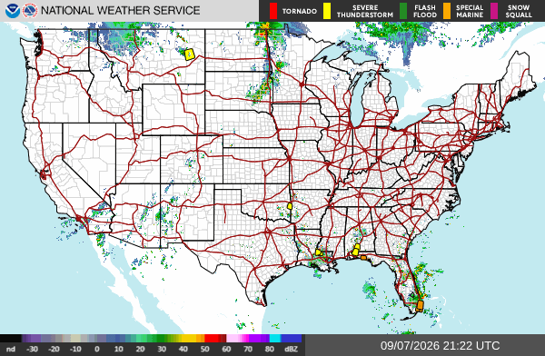
    National Weather Service CONUS radar mosaic showing current precipitation across the United States
    NWS CONUS radar mosaic. Public domain.

    These are the events that generate the restoration work crews actually see: wind-driven roof and siding failures, hail-pocked windows and vehicles, downed trees on service lines, and interior flooding from 2–3 inches in an hour on poorly drained streets. Conditions change fast. Verify with the National Weather Service for the specific county or ZIP before you roll.

    What is live this afternoon

    The Storm Prediction Center 2000 UTC Day 1 outlook holds a Slight Risk of severe thunderstorms across parts of central North Dakota and southeast South Dakota into northeast Nebraska. The headline threat is large hail. A tornado or two is possible in southeast South Dakota. Isolated damaging wind is possible across a broader Marginal Risk from the northern and central Plains into the upper Mississippi Valley. Locally damaging wind gusts remain possible over the central Gulf Coast states.

    No convective watches are in effect as of this writing. Warnings are local Severe Thunderstorm Warnings and Special Weather Statements, plus flood advisories where storms stall.

    Hotspot 1 — Northern Plains: North Dakota, South Dakota, eastern Montana

    A shortwave coming off the northern Rockies is the organizer. SPC expects widely scattered severe storms capable of mainly large hail over northwest into central North Dakota and southeast South Dakota this afternoon into evening. Forecast soundings east of a sharpening dryline in central ND support supercell modes. Large hail is the primary restoration exposure. Isolated tornado risk is highest in southeast South Dakota.

    Official Local Storm Reports already on the board today include 62 mph near Midland, South Dakota; 73 mph west-southwest of Fort Pierre; 59 mph near Forestgrove, Montana; and 63 mph near Winnett, Montana. Overnight and early-morning reports from eastern Montana included estimated 2-inch hail near Shepherd in Yellowstone County, with broken windows and siding damage from wind-driven hail.

    Recent Severe Thunderstorm Warnings from NWS Glasgow have covered Garfield, McCone, Prairie, and Petroleum counties in northeastern Montana for radar-indicated 60 mph gusts. Weather Prediction Center Day 1 also carries a Slight Risk of excessive rainfall for a portion of northwestern Montana.

    Restoration read: hail and wind first. Check roofs, skylights, west- and south-facing windows, and vehicle lots. Trees and service drops follow the 60-plus mph cores.

    Hotspot 2 — Central Gulf Coast: Louisiana, Mississippi, Alabama, Florida Panhandle, far southeast Texas

    Hot, very moist air with MLCAPE in the 2500–3500 J/kg range is supporting scattered afternoon and evening storms. Shear is weak, so this is not a supercell outbreak. The threat is intense downdrafts and slow storm motion. WPC added a Marginal Risk of excessive rainfall from far southeastern Texas into southwestern Alabama and the western Florida Panhandle. Rainfall rates of 2–3 inches in an hour are possible where cells stall near the Texas–Louisiana border.

    Active and recent Severe Thunderstorm Warnings this afternoon have included St. Helena, Livingston, Tangipahoa, and West/East Feliciana parishes in southeast Louisiana (near Hammond, Natalbany, Zachary, Slaughter) and south-central Alabama into northwest Florida (Escambia, Santa Rosa, Conecuh — Brewton, Flomaton, Evergreen, Pollard). Hazard language has been 60 mph gusts and penny-size hail.

    Yesterday’s LSRs already showed the damage type: trees and power lines down near Philadelphia and Greenville, Mississippi, including a microburst with building damage in the Greenville area.

    Restoration read: wind and water, not a hurricane surge. Urban flooding and tree-on-roof jobs in the same zip codes as the warning polygons.

    Hotspot 3 — Florida and the coastal Southeast

    Southeast Florida has been firing strong storms through Labor Day afternoon. NWS and local offices have carried a Severe Thunderstorm Warning for southeastern Martin County with radar-indicated 60 mph gusts and penny hail, plus a Flood Advisory in east-central Palm Beach County after 2–3 inches of rain. Steering is weak; cells can dump on the same neighborhoods twice.

    Northeast Florida into coastal Georgia and southern South Carolina sits under an above-average precipitable-water axis. NWS Jacksonville has been issuing Special Weather Statements for Baker, Columbia, Alachua, Suwannee, and adjacent Georgia counties with 40 mph gusts. WPC notes high neighborhood probabilities for 2- and 3-inch rainfall totals along that coastal moisture axis.

    Restoration read: interior water and urban flooding first, then wind to trees and fascia. Metro Broward/Miami-Dade and the I-10 / I-75 corridors in north Florida are the places to watch hour by hour.

    Pulse table

    RegionMain threatsSPC / WPC levelStatus this afternoon
    Central ND / SE SD / NE NELarge hail, damaging wind, isolated tornadoSlightDeveloping afternoon–evening
    Eastern MT / northern PlainsDamaging wind, hailMarginal + local SVR warningsActive
    Gulf Coast LA–AL–FL PanhandleDamaging wind, flash flood pulsesMarginal + local SVR warningsActive
    SE / NE Florida + coastal GA/SCHeavy rain, gusty wind, urban floodingLocal severe / flood advisoriesActive
    Atlantic tropics vs. U.S. coastNoneNo tropical cycloneQuiet

    What this is not

    This is not a regional derecho and not a hurricane landfall. No watches are up. The work, if it comes, will be scattered: a hail swath through a Dakota county, a microburst block in Louisiana or Alabama, a flooded intersection in Palm Beach or Jacksonville. That is the local-storm pattern restoration desks should staff for tonight.

    Sources and how to verify

    Primary sources: NOAA Storm Prediction Center Day 1 Convective Outlook issued 0259 PM CDT Monday, September 7, 2026; SPC today’s storm reports; Weather Prediction Center Day 1 Excessive Rainfall Outlook; National Hurricane Center Atlantic Tropical Weather Outlook (no tropical cyclone formation expected in the next 7 days); and active NWS warning text from Glasgow MT, New Orleans LA, Mobile AL, Jacksonville FL, and West Palm Beach-area offices.

    Check weather.gov for the county warning, spc.noaa.gov for the outlook and LSRs, and local radar before you treat any polygon as a job ticket. This desk will update when the evening reports close.